45:
364:
52:
641:
635:
29:
251:. Western red cedars grow larger in Lolo National Forest than any other tree species does anywhere in Montana, attaining over 8 feet (250 cm) in diameter and almost 200 feet (60 m) in height. In total, 1,500 plant species exist in the forest as well as 60 species of
1943:
2737:
1213:
195:
are solely in Lolo
National Forest. The forest was created in 1906 from 4 different previous forests which were combined for administrative purposes. Lolo National Forest is west of the
2742:
2717:
2669:
675:
2747:
2727:
2722:
2712:
1936:
2732:
2702:
2189:
1929:
1501:
2663:
751:
794:
2752:
736:
883:
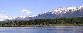
705:
2354:
91:
44:
2449:
2044:
1999:
981:
888:
668:
2049:
2757:
1383:
1031:
948:
913:
850:
817:
696:
458:
2389:
2334:
1979:
1513:
1124:
933:
784:
2414:
1273:
1248:
873:
2244:
543:
2697:
923:
903:
868:
684:
434:
2614:
2249:
2034:
2762:
2649:
1353:
953:
928:
908:
893:
661:
2509:
2464:
2179:
2474:
1471:
1413:
963:
918:
898:
799:
2619:
2029:
1039:
1890:
1728:
1403:
1064:
938:
822:
728:
450:
2324:
1773:
1713:
1543:
1104:
2289:
2254:
2094:
1838:
1738:
1733:
1668:
1538:
958:
878:
741:
408:
Lolo
National Forest was established on September 20, 1906 with 1,211,680 acres (4,903.5 km). On December 16, 1931 part of
1563:
1044:
2299:
2194:
1952:
1858:
1658:
1648:
1643:
1628:
1553:
1318:
1313:
1016:
973:
394:
1693:
2634:
2479:
2209:
2174:
2064:
1703:
1683:
1623:
1368:
1338:
943:
1808:
1708:
1688:
1638:
1618:
1598:
1863:
1788:
1758:
1748:
1698:
1603:
1588:
1583:
1578:
2692:
2229:
2129:
1823:
1813:
1763:
1753:
1718:
1663:
1393:
1268:
1218:
774:
164:
1843:
1818:
1743:
1723:
1608:
1593:
1573:
1568:
1518:
338:
is the location for the forest headquarters and is centrally positioned within sight of the forestlands. There are local
2159:
2124:
1984:
1848:
1833:
1828:
1783:
1548:
1528:
1084:
1059:
713:
184:
142:
1853:
1798:
1768:
1678:
1673:
1653:
1633:
1613:
1523:
575:
515:
2639:
2604:
2469:
2349:
2019:
1803:
1793:
1558:
1533:
1491:
1348:
1165:
322:
The forest has a dozen improved campgrounds and 700 miles (1,100 km) of hiking trails. There are over 100 named
1778:
2644:
2544:
2534:
2484:
2444:
2359:
2329:
2314:
2234:
2204:
2079:
2014:
1448:
1288:
1278:
1258:
1193:
986:
470:
2707:
2629:
2569:
2564:
2454:
2374:
2364:
2339:
2274:
2144:
2084:
2004:
1964:
1428:
1398:
1358:
1328:
1094:
755:
745:
718:
2609:
2594:
2584:
2554:
2519:
2499:
2494:
2489:
2439:
2409:
2369:
2284:
2224:
2214:
2184:
2169:
2164:
2154:
2109:
2099:
2089:
2059:
2054:
1974:
1343:
1228:
1114:
1079:
1011:
1001:
996:
860:
842:
827:
409:
398:
378:
188:
2574:
2539:
2529:
2514:
2504:
2419:
2399:
2394:
2319:
2304:
2279:
2269:
2239:
2134:
2114:
2104:
2069:
2009:
1989:
1969:
1486:
1476:
1461:
1456:
1388:
1378:
1298:
1238:
1054:
832:
809:
417:
402:
386:
382:
374:
2599:
2549:
2524:
2459:
2434:
2429:
2404:
2384:
2294:
2264:
2219:
2119:
2074:
2039:
1994:
1373:
1363:
1203:
1178:
1173:
1089:
1074:
1049:
1006:
991:
766:
582:
522:
413:
390:
192:
2624:
2589:
2579:
2559:
2379:
2344:
2149:
2139:
2024:
1438:
1423:
1408:
1243:
1208:
1069:
590:
272:
28:
2424:
2259:
2199:
1466:
1418:
1323:
1308:
1293:
1283:
1253:
1099:
351:
339:
180:
1333:
430:
268:
204:
490:
1233:
1198:
1183:
1132:
1109:
550:
288:
196:
1481:
1433:
1223:
355:
335:
276:
228:
79:
1906:
1303:
312:
208:
1188:
603:
454:
444:
440:
347:
1921:
1142:
1137:
343:
331:
308:
236:
2686:
1263:
284:
280:
358:. The tallest point in the Lolo is Scapegoat Mountain at 9,186 feet (2,800 m).
304:
264:
200:
647:
300:
176:
653:
106:
93:
296:
439:
Lolo
National Historic Trail - Historic network of trails traveled by the
363:
1156:
688:
248:
222:
211:
168:
68:
621:
252:
240:
175:. The forest spans 2 million acres (8,000 km) and includes four
373:
In descending order of land area the forest is located in parts of
214:
creating a transitional forest that has a high number of different
362:
327:
316:
292:
232:
215:
172:
323:
260:
256:
219:
1925:
657:
152:
244:
171:, United States with the western boundary being the state of
263:. Large mammals found in Lolo National Forest include the
1899:
1883:
1876:
1500:
1447:
1164:
1155:
1123:
1030:
972:
859:
841:
808:
783:
765:
727:
704:
695:
148:
138:
130:
122:
85:
75:
64:
21:
2738:Protected areas of Lewis and Clark County, Montana
457:, former USDA Forest Service nursery designated a
429:Ninemile Wildlands Training Center - Located near
1937:
669:
8:
51:
2743:Protected areas of Flathead County, Montana
2718:Protected areas of Missoula County, Montana
516:"The National Forests of the United States"
2748:Protected areas of Ravalli County, Montana
2728:Protected areas of Granite County, Montana
2723:Protected areas of Sanders County, Montana
2713:Protected areas of Mineral County, Montana
1944:
1930:
1922:
1880:
1161:
701:
676:
662:
654:
491:"Land Areas of the National Forest System"
187:are partially within the forest while the
18:
2733:Protected areas of Powell County, Montana
16:National forest in Montana, United States
574:Davis, Richard C. (September 29, 2005).
2703:National Forests of the Rocky Mountains
576:"National Forests of the United States"
482:
433:, Ninemile Remount Depot listed on the
636:"Lolo National Forest: Special Places"
599:
588:
7:
435:National Register of Historic Places
63:
2753:Protected areas established in 1906
810:National historic and scenic trails
496:. U.S. Forest Service. January 2012
412:was added, followed by portions of
239:share the forest with a variety of
126:2,197,966 acres (8,894.85 km)
33:Rainy Lake in Lolo National Forest
14:
648:"Lolo National Forest Collection"
650:(University of Montana Archives)
544:"USFS Ranger Districts by State"
307:reside in the forest along with
50:
43:
27:
2190:George Washington and Jefferson
1125:National wild and scenic rivers
129:
74:
2758:1906 establishments in Montana
642:"Lolo National Historic Trail"
1:
451:Savenac Historic Tree Nursery
185:Selway-Bitterroot Wilderness
2698:National Forests of Montana
752:Upper Missouri River Breaks
367:Map of Lolo National Forest
2779:
2763:Chinook Jargon place names
1274:Greycliff Prairie Dog Town
1249:First Peoples Buffalo Jump
737:Little Bighorn Battlefield
471:List of forests in Montana
2658:
1960:
861:National Wildlife Refuges
785:National historical parks
38:
26:
843:National recreation area
410:Missoula National Forest
193:Rattlesnake Wildernesses
1299:Lewis and Clark Caverns
644:. Lolo National Forest.
638:. Lolo National Forest.
418:Cabinet National Forest
2355:Mount Baker–Snoqualmie
1404:Tongue River Reservoir
1065:Gates of the Mountains
828:Continental Divide NST
622:"Lolo National Forest"
598:Cite journal requires
583:Forest History Society
523:Forest History Society
459:National Historic Site
414:Selway National Forest
368:
1729:Lower Stillwater Lake
1472:Lubrecht Experimental
833:Pacific Northwest NST
795:Grant–Kohrs Ranch NHS
624:. U.S. Forest Service
366:
2693:Lolo National Forest
2450:Rogue River–Siskiyou
2045:Chattahoochee–Oconee
2000:Beaverhead–Deerlodge
1955:of the United States
1774:North Swan Valley CE
1714:Kootenai/Woods Ranch
1544:Blackfoot-Clearwater
1319:Madison Buffalo Jump
1179:Anaconda Smoke Stack
982:Beaverhead–Deerlodge
767:National battlefield
416:in 1934 and part of
342:district offices in
315:and 30 varieties of
161:Lolo National Forest
153:Lolo National Forest
22:Lolo National Forest
2650:William B. Bankhead
2050:Chequamegon–Nicolet
1369:Rosebud Battlefield
1339:Missouri Headwaters
1032:National Wilderness
818:Lewis and Clark NHT
259:and 300 species of
203:influenced by both
167:located in western
143:U.S. Forest Service
139:Governing body
103: /
2664:Full Detailed List
2475:Samuel R. McKelvie
2390:Okanogan–Wenatchee
2335:Medicine Bow–Routt
1839:Thompson-Fisher CE
1739:Madison-Wall Creek
1734:Madison-Bear Creek
1669:Gravelly-Blacktail
1394:Spring Meadow Lake
1269:Granite Ghost Town
1214:Chief Plenty Coups
1133:East Rosebud Creek
1040:Absaroka–Beartooth
884:Charles M. Russell
787:and historic sites
729:National monuments
369:
255:, 20 varieties of
197:Continental divide
134:September 20, 1906
107:47.150°N 114.450°W
2680:
2679:
2415:Ozark–St. Francis
1980:Apache–Sitgreaves
1919:
1918:
1915:
1914:
1872:
1871:
1564:Buffalo Head Park
1434:Wild Horse Island
1151:
1150:
1105:Selway–Bitterroot
1085:Mission Mountains
1060:Cabinet Mountains
336:Missoula, Montana
229:Western red cedar
158:
157:
80:Missoula, Montana
76:Nearest city
2770:
2708:Bitterroot Range
2290:Lake Tahoe Basin
2245:Humboldt–Toiyabe
1953:National Forests
1946:
1939:
1932:
1923:
1907:CSKT Bison Range
1891:American Prairie
1881:
1859:War Dance Island
1659:Garrity Mountain
1649:Fresno Tailwater
1644:Fresno Reservoir
1629:Fleecer Mountain
1554:Blue Eyed Nellie
1349:Parker Homestead
1162:
1050:Bear Trap Canyon
1045:Anaconda–Pintler
974:National Forests
702:
678:
671:
664:
655:
632:
630:
629:
608:
607:
601:
596:
594:
586:
580:
571:
565:
564:
562:
561:
555:
549:. Archived from
548:
540:
534:
533:
531:
529:
520:
512:
506:
505:
503:
501:
495:
487:
118:
117:
115:
114:
113:
112:47.150; -114.450
108:
104:
101:
100:
99:
96:
54:
53:
47:
31:
19:
2778:
2777:
2773:
2772:
2771:
2769:
2768:
2767:
2683:
2682:
2681:
2676:
2654:
2615:Wallowa–Whitman
2300:Lewis and Clark
2255:Idaho Panhandle
2195:Gifford Pinchot
2035:Caribou–Targhee
1956:
1950:
1920:
1911:
1895:
1868:
1694:Isaac Homestead
1505:
1503:
1496:
1443:
1414:Travelers' Rest
1354:Pictograph Cave
1289:Lake Mary Ronan
1259:Frenchtown Pond
1219:Clark's Lookout
1194:Beavertail Hill
1189:Beaverhead Rock
1147:
1119:
1026:
1017:Lewis and Clark
968:
889:Creedman Coulee
855:
837:
804:
786:
779:
761:
723:
691:
685:Protected areas
682:
627:
625:
620:
617:
612:
611:
597:
587:
578:
573:
572:
568:
559:
557:
553:
546:
542:
541:
537:
527:
525:
518:
514:
513:
509:
499:
497:
493:
489:
488:
484:
479:
467:
453:- Located near
445:Lewis and Clark
426:
395:Lewis and Clark
371:
370:
165:national forest
111:
109:
105:
102:
97:
94:
92:
90:
89:
71:, United States
60:
59:
58:
57:
56:
55:
34:
17:
12:
11:
5:
2776:
2774:
2766:
2765:
2760:
2755:
2750:
2745:
2740:
2735:
2730:
2725:
2720:
2715:
2710:
2705:
2700:
2695:
2685:
2684:
2678:
2677:
2675:
2674:
2673:
2672:
2659:
2656:
2655:
2653:
2652:
2647:
2642:
2637:
2635:White Mountain
2632:
2627:
2622:
2617:
2612:
2607:
2602:
2597:
2592:
2587:
2582:
2577:
2572:
2567:
2562:
2557:
2552:
2547:
2542:
2537:
2532:
2527:
2522:
2517:
2512:
2510:Shasta–Trinity
2507:
2502:
2497:
2492:
2487:
2482:
2480:San Bernardino
2477:
2472:
2467:
2465:Salmon–Challis
2462:
2457:
2452:
2447:
2442:
2437:
2432:
2427:
2422:
2417:
2412:
2407:
2402:
2397:
2392:
2387:
2382:
2377:
2372:
2367:
2362:
2357:
2352:
2347:
2342:
2337:
2332:
2327:
2322:
2317:
2312:
2307:
2302:
2297:
2292:
2287:
2282:
2277:
2272:
2267:
2262:
2257:
2252:
2250:Huron–Manistee
2247:
2242:
2237:
2232:
2227:
2222:
2217:
2212:
2210:Green Mountain
2207:
2202:
2197:
2192:
2187:
2182:
2180:Fremont–Winema
2177:
2175:Francis Marion
2172:
2167:
2162:
2157:
2152:
2147:
2142:
2137:
2132:
2127:
2122:
2117:
2112:
2107:
2102:
2097:
2092:
2087:
2082:
2077:
2072:
2067:
2065:Choctawhatchee
2062:
2057:
2052:
2047:
2042:
2037:
2032:
2027:
2022:
2017:
2012:
2007:
2002:
1997:
1992:
1987:
1982:
1977:
1972:
1967:
1961:
1958:
1957:
1951:
1949:
1948:
1941:
1934:
1926:
1917:
1916:
1913:
1912:
1910:
1909:
1903:
1901:
1897:
1896:
1894:
1893:
1887:
1885:
1878:
1874:
1873:
1870:
1869:
1867:
1866:
1861:
1856:
1851:
1846:
1841:
1836:
1831:
1826:
1821:
1816:
1811:
1806:
1801:
1796:
1791:
1786:
1781:
1776:
1771:
1766:
1761:
1756:
1751:
1746:
1741:
1736:
1731:
1726:
1721:
1716:
1711:
1706:
1704:Kootenai/Falls
1701:
1696:
1691:
1686:
1684:Horseshoe Lake
1681:
1676:
1671:
1666:
1661:
1656:
1651:
1646:
1641:
1636:
1631:
1626:
1624:Flathead River
1621:
1616:
1611:
1606:
1601:
1596:
1591:
1586:
1581:
1576:
1571:
1566:
1561:
1556:
1551:
1546:
1541:
1536:
1531:
1526:
1521:
1516:
1510:
1508:
1498:
1497:
1495:
1494:
1492:Thompson River
1489:
1484:
1479:
1474:
1469:
1464:
1459:
1453:
1451:
1445:
1444:
1442:
1441:
1436:
1431:
1429:Whitefish Lake
1426:
1421:
1416:
1411:
1406:
1401:
1399:Thompson Falls
1396:
1391:
1386:
1381:
1376:
1371:
1366:
1361:
1359:Pirogue Island
1356:
1351:
1346:
1341:
1336:
1331:
1329:Medicine Rocks
1326:
1321:
1316:
1311:
1306:
1301:
1296:
1291:
1286:
1281:
1276:
1271:
1266:
1261:
1256:
1251:
1246:
1241:
1236:
1231:
1226:
1221:
1216:
1211:
1206:
1201:
1196:
1191:
1186:
1181:
1176:
1170:
1168:
1159:
1153:
1152:
1149:
1148:
1146:
1145:
1140:
1135:
1129:
1127:
1121:
1120:
1118:
1117:
1112:
1107:
1102:
1097:
1095:Red Rock Lakes
1092:
1087:
1082:
1077:
1072:
1067:
1062:
1057:
1052:
1047:
1042:
1036:
1034:
1028:
1027:
1025:
1024:
1019:
1014:
1009:
1004:
999:
994:
989:
984:
978:
976:
970:
969:
967:
966:
961:
956:
951:
949:Red Rock Lakes
946:
941:
936:
931:
926:
921:
916:
914:Lake Thibadeau
911:
906:
901:
896:
891:
886:
881:
876:
871:
865:
863:
857:
856:
854:
853:
851:Bighorn Canyon
847:
845:
839:
838:
836:
835:
830:
825:
820:
814:
812:
806:
805:
803:
802:
797:
791:
789:
781:
780:
778:
777:
771:
769:
763:
762:
760:
759:
749:
742:Pompeys Pillar
739:
733:
731:
725:
724:
722:
721:
716:
710:
708:
706:National parks
699:
693:
692:
683:
681:
680:
673:
666:
658:
652:
651:
645:
639:
633:
616:
615:External links
613:
610:
609:
600:|journal=
566:
535:
507:
481:
480:
478:
475:
474:
473:
466:
463:
462:
461:
448:
437:
425:
424:Special places
422:
361:
360:
334:. The city of
332:Flathead River
330:including the
309:trumpeter swan
237:whitebark pine
156:
155:
150:
146:
145:
140:
136:
135:
132:
128:
127:
124:
120:
119:
87:
83:
82:
77:
73:
72:
66:
62:
61:
49:
48:
42:
41:
40:
39:
36:
35:
32:
24:
23:
15:
13:
10:
9:
6:
4:
3:
2:
2775:
2764:
2761:
2759:
2756:
2754:
2751:
2749:
2746:
2744:
2741:
2739:
2736:
2734:
2731:
2729:
2726:
2724:
2721:
2719:
2716:
2714:
2711:
2709:
2706:
2704:
2701:
2699:
2696:
2694:
2691:
2690:
2688:
2671:
2668:
2667:
2666:
2665:
2661:
2660:
2657:
2651:
2648:
2646:
2643:
2641:
2638:
2636:
2633:
2631:
2628:
2626:
2623:
2621:
2620:Wasatch–Cache
2618:
2616:
2613:
2611:
2608:
2606:
2603:
2601:
2598:
2596:
2593:
2591:
2588:
2586:
2583:
2581:
2578:
2576:
2573:
2571:
2568:
2566:
2563:
2561:
2558:
2556:
2553:
2551:
2548:
2546:
2543:
2541:
2538:
2536:
2533:
2531:
2528:
2526:
2523:
2521:
2518:
2516:
2513:
2511:
2508:
2506:
2503:
2501:
2498:
2496:
2493:
2491:
2488:
2486:
2483:
2481:
2478:
2476:
2473:
2471:
2468:
2466:
2463:
2461:
2458:
2456:
2453:
2451:
2448:
2446:
2443:
2441:
2438:
2436:
2433:
2431:
2428:
2426:
2423:
2421:
2418:
2416:
2413:
2411:
2408:
2406:
2403:
2401:
2398:
2396:
2393:
2391:
2388:
2386:
2383:
2381:
2378:
2376:
2373:
2371:
2368:
2366:
2363:
2361:
2358:
2356:
2353:
2351:
2348:
2346:
2343:
2341:
2338:
2336:
2333:
2331:
2328:
2326:
2323:
2321:
2318:
2316:
2313:
2311:
2308:
2306:
2303:
2301:
2298:
2296:
2293:
2291:
2288:
2286:
2283:
2281:
2278:
2276:
2273:
2271:
2268:
2266:
2263:
2261:
2258:
2256:
2253:
2251:
2248:
2246:
2243:
2241:
2238:
2236:
2233:
2231:
2230:Holly Springs
2228:
2226:
2223:
2221:
2218:
2216:
2213:
2211:
2208:
2206:
2203:
2201:
2198:
2196:
2193:
2191:
2188:
2186:
2183:
2181:
2178:
2176:
2173:
2171:
2168:
2166:
2163:
2161:
2158:
2156:
2153:
2151:
2148:
2146:
2143:
2141:
2138:
2136:
2133:
2131:
2130:Davy Crockett
2128:
2126:
2123:
2121:
2118:
2116:
2113:
2111:
2108:
2106:
2103:
2101:
2098:
2096:
2095:Coeur d'Alene
2093:
2091:
2088:
2086:
2083:
2081:
2078:
2076:
2073:
2071:
2068:
2066:
2063:
2061:
2058:
2056:
2053:
2051:
2048:
2046:
2043:
2041:
2038:
2036:
2033:
2031:
2030:Bridger–Teton
2028:
2026:
2023:
2021:
2018:
2016:
2013:
2011:
2008:
2006:
2003:
2001:
1998:
1996:
1993:
1991:
1988:
1986:
1983:
1981:
1978:
1976:
1973:
1971:
1968:
1966:
1963:
1962:
1959:
1954:
1947:
1942:
1940:
1935:
1933:
1928:
1927:
1924:
1908:
1905:
1904:
1902:
1898:
1892:
1889:
1888:
1886:
1882:
1879:
1875:
1865:
1862:
1860:
1857:
1855:
1852:
1850:
1847:
1845:
1842:
1840:
1837:
1835:
1832:
1830:
1827:
1825:
1822:
1820:
1817:
1815:
1812:
1810:
1809:Seven Sisters
1807:
1805:
1802:
1800:
1797:
1795:
1792:
1790:
1787:
1785:
1782:
1780:
1777:
1775:
1772:
1770:
1767:
1765:
1762:
1760:
1757:
1755:
1752:
1750:
1747:
1745:
1742:
1740:
1737:
1735:
1732:
1730:
1727:
1725:
1722:
1720:
1717:
1715:
1712:
1710:
1709:Kootenai/West
1707:
1705:
1702:
1700:
1697:
1695:
1692:
1690:
1689:Howard Valley
1687:
1685:
1682:
1680:
1677:
1675:
1672:
1670:
1667:
1665:
1662:
1660:
1657:
1655:
1652:
1650:
1647:
1645:
1642:
1640:
1639:Freezout Lake
1637:
1635:
1632:
1630:
1627:
1625:
1622:
1620:
1619:Flathead Lake
1617:
1615:
1612:
1610:
1607:
1605:
1602:
1600:
1599:Dome Mountain
1597:
1595:
1592:
1590:
1587:
1585:
1582:
1580:
1577:
1575:
1572:
1570:
1567:
1565:
1562:
1560:
1557:
1555:
1552:
1550:
1547:
1545:
1542:
1540:
1537:
1535:
1532:
1530:
1527:
1525:
1522:
1520:
1517:
1515:
1514:Amelia Island
1512:
1511:
1509:
1507:
1499:
1493:
1490:
1488:
1485:
1483:
1480:
1478:
1475:
1473:
1470:
1468:
1465:
1463:
1460:
1458:
1455:
1454:
1452:
1450:
1449:State forests
1446:
1440:
1437:
1435:
1432:
1430:
1427:
1425:
1422:
1420:
1417:
1415:
1412:
1410:
1407:
1405:
1402:
1400:
1397:
1395:
1392:
1390:
1387:
1385:
1382:
1380:
1377:
1375:
1372:
1370:
1367:
1365:
1362:
1360:
1357:
1355:
1352:
1350:
1347:
1345:
1344:Painted Rocks
1342:
1340:
1337:
1335:
1332:
1330:
1327:
1325:
1322:
1320:
1317:
1315:
1312:
1310:
1307:
1305:
1302:
1300:
1297:
1295:
1292:
1290:
1287:
1285:
1282:
1280:
1277:
1275:
1272:
1270:
1267:
1265:
1264:Giant Springs
1262:
1260:
1257:
1255:
1252:
1250:
1247:
1245:
1242:
1240:
1237:
1235:
1232:
1230:
1229:Council Grove
1227:
1225:
1222:
1220:
1217:
1215:
1212:
1210:
1207:
1205:
1202:
1200:
1197:
1195:
1192:
1190:
1187:
1185:
1182:
1180:
1177:
1175:
1172:
1171:
1169:
1167:
1163:
1160:
1158:
1154:
1144:
1141:
1139:
1136:
1134:
1131:
1130:
1128:
1126:
1122:
1116:
1115:Welcome Creek
1113:
1111:
1108:
1106:
1103:
1101:
1098:
1096:
1093:
1091:
1088:
1086:
1083:
1081:
1080:Medicine Lake
1078:
1076:
1073:
1071:
1068:
1066:
1063:
1061:
1058:
1056:
1053:
1051:
1048:
1046:
1043:
1041:
1038:
1037:
1035:
1033:
1029:
1023:
1020:
1018:
1015:
1013:
1010:
1008:
1005:
1003:
1000:
998:
995:
993:
990:
988:
985:
983:
980:
979:
977:
975:
971:
965:
962:
960:
957:
955:
952:
950:
947:
945:
942:
940:
937:
935:
934:Medicine Lake
932:
930:
927:
925:
922:
920:
917:
915:
912:
910:
907:
905:
902:
900:
897:
895:
892:
890:
887:
885:
882:
880:
877:
875:
872:
870:
867:
866:
864:
862:
858:
852:
849:
848:
846:
844:
840:
834:
831:
829:
826:
824:
823:Nez Perce NHT
821:
819:
816:
815:
813:
811:
807:
801:
800:Nez Perce NHP
798:
796:
793:
792:
790:
788:
782:
776:
773:
772:
770:
768:
764:
757:
753:
750:
747:
743:
740:
738:
735:
734:
732:
730:
726:
720:
717:
715:
712:
711:
709:
707:
703:
700:
698:
694:
690:
686:
679:
674:
672:
667:
665:
660:
659:
656:
649:
646:
643:
640:
637:
634:
623:
619:
618:
614:
605:
592:
584:
577:
570:
567:
556:on 2012-01-19
552:
545:
539:
536:
524:
517:
511:
508:
492:
486:
483:
476:
472:
469:
468:
464:
460:
456:
452:
449:
446:
442:
438:
436:
432:
428:
427:
423:
421:
419:
415:
411:
406:
404:
400:
396:
392:
388:
384:
380:
376:
365:
359:
357:
353:
349:
345:
341:
337:
333:
329:
325:
320:
318:
314:
310:
306:
302:
298:
294:
290:
286:
285:bighorn sheep
282:
281:mountain goat
278:
274:
270:
266:
262:
258:
254:
250:
246:
242:
238:
234:
230:
226:
224:
221:
217:
213:
210:
206:
202:
198:
194:
190:
189:Welcome Creek
186:
182:
178:
174:
170:
166:
162:
154:
151:
147:
144:
141:
137:
133:
125:
121:
116:
88:
84:
81:
78:
70:
67:
46:
37:
30:
25:
20:
2662:
2325:Manti–La Sal
2309:
2160:Finger Lakes
2125:Daniel Boone
1985:Apalachicola
1864:Warm Springs
1789:Robb-Ledford
1759:Mount Silcox
1749:Mount Haggin
1699:Judith River
1604:Ear Mountain
1589:Dodson Creek
1584:Canyon Ferry
1579:Canyon Creek
1389:Somers Beach
1379:Sluice Boxes
1055:Bob Marshall
1021:
874:Black Coulee
626:. Retrieved
591:cite journal
569:
558:. Retrieved
551:the original
538:
526:. Retrieved
510:
498:. Retrieved
485:
407:
372:
346:, Missoula,
321:
305:golden eagle
227:
201:biodiversity
160:
159:
2670:former list
2640:White River
2605:Uncompahgre
2470:Sam Houston
2350:Monongahela
2020:Black Hills
1824:Smith River
1814:Silver Gate
1764:Nevada Lake
1754:Mount Jumbo
1719:Lake Helena
1664:Grant Marsh
1384:Smith River
1374:Salmon Lake
1364:Placid Lake
1204:Black Sandy
1174:Ackley Lake
1166:State parks
1090:Rattlesnake
1075:Lee Metcalf
924:Lee Metcalf
904:Hewitt Lake
869:Benton Lake
719:Yellowstone
528:November 2,
352:Seeley Lake
299:. Both the
277:timber wolf
205:continental
179:areas; the
131:Established
110: /
86:Coordinates
2687:Categories
2645:Willamette
2545:Stanislaus
2535:Six Rivers
2485:San Isabel
2445:Rio Grande
2360:Mount Hood
2330:Mark Twain
2315:Los Padres
2235:Homochitto
2205:Grand Mesa
2080:Clearwater
2015:Bitterroot
1844:Three Mile
1819:Silver Run
1744:Milk River
1724:Lost Creek
1609:Elk Island
1594:Dodson Dam
1574:Calf Creek
1569:Bull River
1519:Aunt Molly
1504:Management
1487:Swan River
1477:Stillwater
1462:Coal Creek
1457:Clearwater
1439:Yellow Bay
1424:West Shore
1409:Tower Rock
1314:Lost Creek
1279:Hell Creek
1244:Fish Creek
1209:Brush Lake
1070:Great Bear
987:Bitterroot
954:Swan River
929:Lost Trail
909:Lake Mason
894:Grass Lake
628:2006-07-08
560:2009-04-14
477:References
431:Frenchtown
405:counties.
269:black bear
199:and has a
177:wilderness
2630:Wenatchee
2570:Tombigbee
2565:Talladega
2455:Roosevelt
2375:Nez Perce
2365:Nantahala
2340:Mendocino
2275:Kisatchie
2145:Deschutes
2085:Cleveland
2005:Bienville
1965:Allegheny
1884:Nonprofit
1849:Threemile
1834:Swan Lake
1829:Sun River
1784:Ray Kuhns
1549:Blackleaf
1529:Beartooth
1419:Wayfarers
1324:Makoshika
1309:Lone Pine
1294:Les Mason
1284:Lake Elmo
1254:Fort Owen
1100:Scapegoat
964:War Horse
919:Lamesteer
899:Hailstone
441:Nez Perce
420:in 1954.
326:and five
297:mule deer
181:Scapegoat
2610:Uwharrie
2595:Umatilla
2585:Tuskegee
2555:Superior
2520:Shoshone
2500:Sawtooth
2495:Santa Fe
2490:San Juan
2440:Prescott
2410:Ouachita
2370:Nebraska
2285:Kootenai
2225:Hiawatha
2215:Gunnison
2185:Gallatin
2170:Flathead
2165:Fishlake
2155:Eldorado
2110:Coronado
2100:Colville
2090:Coconino
2060:Chippewa
2055:Cherokee
1975:Angelina
1854:Vandalia
1799:Roundhom
1769:Ninepipe
1679:Hinsdale
1674:Haymaker
1654:Gallatin
1634:Fox Lake
1614:F Island
1539:Big Lake
1524:Badlands
1502:Wildlife
1334:Milltown
1143:Missouri
1138:Flathead
1012:Kootenai
1002:Gallatin
997:Flathead
939:Ninepipe
775:Big Hole
500:June 25,
465:See also
399:Flathead
379:Missoula
356:Superior
209:maritime
183:and the
98:114°27′W
65:Location
2575:Tongass
2540:St. Joe
2530:Siuslaw
2515:Shawnee
2505:Sequoia
2420:Payette
2400:Osceola
2395:Olympic
2320:Malheur
2305:Lincoln
2280:Klamath
2270:Kaniksu
2240:Hoosier
2135:De Soto
2115:Croatan
2105:Conecuh
2070:Chugach
2010:Bighorn
1990:Arapaho
1970:Angeles
1804:Sanders
1794:Rookery
1559:Bowdoin
1534:Beckman
1467:Lincoln
1234:Elkhorn
1199:Big Arm
1184:Bannack
1110:UL Bend
959:UL Bend
879:Bowdoin
714:Glacier
697:Federal
689:Montana
403:Ravalli
387:Granite
383:Sanders
375:Mineral
265:grizzly
253:mammals
249:species
223:species
212:weather
169:Montana
149:Website
95:47°09′N
69:Montana
2600:Umpqua
2550:Sumter
2525:Sierra
2460:Sabine
2435:Plumas
2430:Pisgah
2405:Ottawa
2385:Ochoco
2295:Lassen
2265:Kaibab
2220:Helena
2120:Custer
2075:Cibola
2040:Carson
1995:Ashley
1900:Tribal
1239:Finley
1224:Cooney
1007:Helena
992:Custer
455:Haugan
401:, and
391:Powell
354:, and
348:Plains
340:ranger
328:rivers
313:herons
273:cougar
241:spruce
2625:Wayne
2590:Uinta
2580:Tonto
2560:Tahoe
2380:Ocala
2345:Modoc
2150:Dixie
2140:Delta
2025:Boise
1877:Other
1779:Pablo
1506:Areas
1304:Logan
1157:State
944:Pablo
579:(PDF)
554:(PDF)
547:(PDF)
519:(PDF)
494:(PDF)
344:Huson
324:lakes
317:ducks
293:moose
261:birds
247:tree
233:larch
216:plant
173:Idaho
163:is a
2425:Pike
2310:Lolo
2260:Inyo
2200:Gila
1482:Sula
1022:Lolo
604:help
530:2017
502:2012
443:and
303:and
301:bald
295:and
257:fish
243:and
235:and
220:tree
218:and
207:and
191:and
123:Area
756:BLM
746:BLM
687:of
289:elk
271:,
245:fir
2689::
595::
593:}}
589:{{
581:.
521:.
397:,
393:,
389:,
385:,
381:,
377:,
350:,
319:.
311:,
291:,
287:,
283:,
279:,
275:,
267:,
231:,
225:.
1945:e
1938:t
1931:v
758:)
754:(
748:)
744:(
677:e
670:t
663:v
631:.
606:)
602:(
585:.
563:.
532:.
504:.
447:.
Text is available under the Creative Commons Attribution-ShareAlike License. Additional terms may apply.