195:(formerly called the Department of Lands and Forestry). The park is not as well known as some other local public spaces despite its proximity to central Halifax and its large size, rivalling that of the Halifax peninsula. In 2003, the Department of Natural Resources entered into consultation with the Long Lake Provincial Park Association on the development of a park management plan which was completed in 2008 and subsequently adopted for park management purposes. In early 2015 the Long Lake Provincial Park Association started to build accessible walking and cycling trails on the east side of the lake near Northwest Arm Drive (Dunbrack Street) in Spryfield. These were constructed under a formal agreement between the association and the provincial government. There are now approximately 5.5 kilometres (3.4 mi) of wide multi-use trails that lie along the east side of Long Lake, together with a loop around Withrod lake. Benches are installed along the trail and members of the public can have plaques installed on the benches. There is also a parking lot and a washroom across from the Cowie Hill Road. Another parking lot has been added along with a Kayak/Canoe launch at the location of the old pumphouse on Old Sambro Road across from Schnare Street.
601:
45:
322:
346:
164:
Long Lake, again significantly expanding its area. A pipeline was built connecting the two lakes, and to the adjacent Chain Lakes. The entire area has been logged extensively in the early part of the 20th century, but a few scattered old growth trees remain. The north eastern side of Long lake featured world war I barracks location, extensive trenches and machine gun battle emplacement which protected movement from the St. Margaret's Bay and
Prospect bay roads into Halifax. This fortification is known as Chain Lake Position - Locality 2
132:
1629:
29:
354:
236:
228:
421:. This is not as popular an activity as it could be, due to the scarcity of boat-launching places. The new kayak launch on Old Sambro has helped improve this access. Use of motorized vehicles of any kind, including boats, is prohibited within park boundaries, as with other provincial parks in Nova Scotia, so park planners have not made provisions for an easy place to launch boats, out of concern that power boats might also be launched.
1604:
52:
1616:
313:
Many of the trails are organized into a series of loops (approximately 9.5 kilometres (5.9 mi) of trail) that can be ridden a number of ways. Most of these trails are unmarked and are generally inconsistent with the park's management plan. This northern hardwood-dominated portion of Long Lake
Provincial Park receives most of the park's visitors.
309:
lot. The management plan had proposed that another parking lot be built off the Old Sambro Rd, but this component of the plan has been shelved. There has been discussion with the city for use of a portion of the
Exhibition Park lands for parking in association with a major park access point there, as proposed in the park's management plan.
210:-oriented" provincial park and can be viewed as an "urban wilderness", even though much of its area has been altered by previous human activities and uses. It is anticipated that no campgrounds or other high-impact projects will be developed in the park in the foreseeable future. This is in contrast to an aborted early plan to develop a
554:
to cut trees on property owned by Dexter along Old Sambro Road, beside the park. Resourcetec subcontracted the work to Scott and
Stewart Forestry Consultants, who accidentally cut down trees on Crown land. Resourcetec was alleged to be the most culpable party. The company pleaded guilty and was fined
517:
on
September 29, 2003. Many paths were blocked and some of the less-used ones remain that way. Most have since been cleared by citizens, however, since the province does not actively manage this provincial park. The slash created by these downed trees, which include many mature large, mature spruce
167:
The lands were part of
Halifax's old water supply system. In order to protect the water quality, about 6,500 hectares (16,000 acres) of land was left "virtually untouched" into the 1970s. In the years leading up to the 1977 commissioning of the new Pockwock water supply system, concern began to mount
312:
The northern portion of Long Lake
Provincial Park (north of Long Lake itself) and the adjacent Water Commission lands between the park's boundaries and the St. Margaret's Bay Rd. is home to a network of informal narrow single-track mountain bike trails that is noteworthy for its challenging terrain.
218:
along part of this roadbed has resulted in a strip of exposed bedrock which has been dubbed the "scar road" and is easily visible from the air. Most of the park is designated as a "resource conservation zone" in the park's management plan. The plan also identified a wetland area as an environmental
163:
which provided the stones for many of the 19th century buildings in downtown
Halifax. As part of its development as Halifax's watershed lands, in the early part of the 20th century an earthen dam was erected on Spruce Hill Lake, greatly enlarging it. A long concrete and earth dam was constructed on
591:
The park's fauna is healthy and varied and includes many deer, the occasional moose, multitudes of squirrels, snowshoe hares, foxes, bobcats, chipmunks, three or four species of frogs and salamanders, many fish and bird species, beavers (who have extensively altered portions of the park), muskrats,
583:
in the SE region - largely red and black spruce, balsam fir and red maple. As with most parts of Nova Scotia, large, old white pines dot the park, being left over from the logging which most areas underwent before their designation as watershed lands. It is worth noting that healthy populations of
308:
near the west end of Long Lake accessible from the St. Margaret's Bay Road, the relatively large lot maintained by the Long Lake
Provincial Park Association off Dunbrack Street, and their smaller lot near Schnare Street. A canoe-kayak-paddle board launch area is associated with this smaller parking
150:
after
Halifax's water supply had been shifted from the Spruce Hill/Long Lake/Chain Lakes watershed to the Pockwock Lake watershed near Hammonds Plains. The 2,095-hectare (5,180-acre) park, formally established in 1984, constitutes the bulk of these former watershed lands. Other portions were deeded
381:
Swimmers: Long Lake is deep, the water quality is excellent overall, and there are several good spots for swimming. As with other lakes in the region, the water is warm enough for swimming from June through September. Much of the swimming in the lake takes place in the small area discussed above
329:
Long Lake Provincial Park is home to a number of lakes and ponds. The eponymous Long Lake, with an area of 154 hectares (380 acres), is the largest. It was created in the 19th century when a wooden dam was built on McIntosh Run, causing rising water levels to connect two pre-existing lakes, Cocked
198:
On behalf of Bicycle Nova Scotia and the mountain bike community in general Randy Gray submitted a Mountain Biking Management Plan to be included either in the main body or as an appendix to the Management Plan. This was submitted after about six years of involvement and consultation with the Long
625:
newer trails developed by mountain bikers, as discussed above. Many of the more extensively used trails suffer from erosional problems, and various remedial proposals including trail closures have been discussed as part of the creation of the park's development plan. However, the majority of the
377:
Dog walkers: Walking dogs on leash along trails in the park is permitted under park regulations and this is a popular activity. Despite prohibition of unleashed dogs in provincial parks, Long Lake Provincial Park had been popular for off-leash dog walking in the Halifax area at one time. The
378:
activity was mostly in the area within 20-minutes walk of the parking lot on St. Margaret's Bay Road, mentioned above. The dog-walking pattern has evolved in recent years as a result of new trail development and greater awareness of provincial park regulations that prohibit this activity.
333:
The park's second-largest water body, Spruce Hill Lake, was formed in a similar manner. A dam was built on Spruce Lake in 1867, connecting it to nearby Fosses Hill Lake. Today, the resulting Spruce Hill Lake is 102 hectares (250 acres) large, and has a maximum depth of 12 metres.
633:
in 2016. It includes washrooms, benches, a car park, and bicycle racks. The trail system can be accessed at three points on Dunbrack Street and three points on Old Sambro Road The trails were funded by a private developer building a subdivision on the opposite side of Dunbrack
386:
enters the lake, near the southwest end. There is very limited trail access to the lake outside of this area, but for those adventurous enough two small sandy beaches offer secluded swimming on the south side. At the other end of the park, there is swimming spot on the earthen
441:
Groups on organized field outings: Youth groups of various kinds, hiking clubs, cross-country runners, field naturalists, hiking associations, school groups and others often make use of the park's extensive trail system for outings of both the educational and recreational
456:
Hunting: This is not a serious problem in the park, fortunately, but it does occur nevertheless. Mostly, deer are the target of hunting in the area. Though, hunting is permitted on the Crown land outside of the park boundaries so long as legal safety distances are
476:
Party use, usually by youth: this is a serious problem because of the fire hazard involved, and because frequently used party spots become trampled clearings which both encourage future use and would take decades to recover if left alone.
174:
The 2,095-hectare (5,180-acre) watershed lands were acquired by the province in 1981 and put under the management of the Department of Natural Resources for use as a provincial park. Long Lake Provincial Park was formally created by
470:: This is a periodic problem, especially when trees are cut for firewood and for use in shelter and "camp" building. No camping is permitted within park boundaries, and no camp grounds are included in the current management plan.
247:(formerly Northwest Arm Drive) on the NE, Watershed Commission lands bisected by the St. Margaret's Bay Rd. on the north, Prospect Road on the west, and the Terence Bay Wilderness Area to the south. It can be viewed from:
1647:
374:: folks simply out for a walk in the woods. Most hikers again use this same small northern portion of the park, but some make use of the older network of old roads and trails in the much larger portion south of Long Lake.
431:: the park's terrain is quite variable and there are many excellent habitats for bird watching. Access to many of the best habitats for birds is still limited, but this is seldom a barrier to the most eager of birders.
219:
protection zone, while two small selected areas were designated for "resource development". One of these contains the canoe/kayak launch area near Schnare Street (described above) along with a short loop trail.
291:
entrance has a path leading to Harrietsfield, past Spruce Hill Lake, but actually getting to Harrietsfield via this pathway is difficult because access to Harrietsfield is blocked by private property,
151:
to the municipality of Halifax, and the area around the Chain Lakes is still administered by the Halifax Regional Water Commission, since the Chain Lakes remain the city's emergency water supply.
932:
877:
407:: an active and long-established geocaching tradition exists in the Halifax region, and the area within the park is particularly popular, perhaps due to the varied terrain within park boundaries,
214:
area and artificial beach on the west side of Long Lake. An abandoned roadbed stretching part of the way between Long Lake and the Old Sambro Road is a residue of this earlier plan. Extensive
368:, who developed a trail system between 1994 and 1999. However, the number of bikers has declined significantly since about 2001, when trail systems began to be created elsewhere in the area.
897:
563:
Habitats within the park are extremely varied, and include various kinds of wetlands, old-growth vegetative successions from areas previously farmed, an area planted with pine trees by the
887:
882:
872:
990:
942:
922:
912:
867:
168:
over the fate of the old watershed lands, which were considered to have high ecological and recreational value. Residents feared that the area would be spoiled by suburban development.
179:(OIC) 84-1189 on October 9, 1984, comprising part of the old watershed lands. Application was altered (by the withdrawal of 1.23 hectares (3.0 acres)) by OIC 93-364 on April 14, 1993.
952:
947:
937:
727:
927:
1367:
917:
907:
892:
44:
1577:
304:
There is room along the roadside at a few of the more frequently used informal entrances for 2 to 4 vehicles. In addition, there are three parking lots: the one built by the
453:: as discussed elsewhere, this activity occurs exclusively in the large southern portion of the park, and has caused considerable environmental harm, especially to wetlands.
272:
4 or 5 off Dunbrack Street, most notably the old road across from Peter Saulnier Drive, which goes past Withrod Lake to some of the more popular swimming spots on Long Lake,
619:
The "pipeline trail", above the pipeline between Spruce Hill Lake and Long Lake. Most of this has unfortunately become flooded and swampy in recent years, hence impassable,
543:, especially in boggy areas and along trails. This is an ongoing problem which will hopefully be remediated via education and more vigorous enforcement of regulations.
434:
Photography: The park offers a great wealth of opportunities for scenic and natural history photography, from scenic vistas around the lakes, to the many large glacial
492:
left at party spots, there have been instances of deliberate dumping of wastes at the park's periphery where roads provide access to places that are hidden from view.
902:
275:
from two parking lots maintained by Long Lake Provincial Park Association situated on Dunbrack Street at Cowie Hill Road and at Old Sambro Road near Schnare Street,
1133:
438:(boulders dropped by the melting glaciers as they retreated, about 14,000 years ago), beautiful old trees, and a surprisingly wide variety of flora and fauna.
1093:
1018:
842:
481:
and potential wildlife disturbance are also factors to consider, plus the safety hazards associated with parties in semi-remote areas involving extensive
1273:
1372:
1297:
1268:
1700:
622:
older trails associated with habitation, watershed usage, quarries and general uses such as fishing, swimming, berry picking, hiking and hunting and
159:
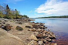
The lands included within the present park boundaries have had a long history of human use, including logging, several farms and many small granite
1608:
1521:
1437:
171:
A regional plan adopted in July 1975 proposed that the watershed lands would form one of seven new regional parks in the Halifax-Dartmouth area.
779:
1695:
1588:
1532:
851:
518:
trees, has created a significant fire hazard, although to date this has not created a problem and is typical of natural forests in the region.
269:
several along the St. Margaret's Bay Rd. (including from the parking lot operated by Halifax Regional Municipality near the Prospect Rd. exit),
1038:
555:
in 2016. In response to this incident, provincial fines against illegal cutting on Crown land were significantly increased in November 2016.
498:
growing: Not a serious or widespread problem, but over the years a number of small plots of marijuana have been found within park boundaries.
592:
snakes and others. Unverified reports of lynx tracks and spoor also exist . Bears have not been reported within the park in recent years.
473:
Evidence of many illegal campfires is provided by the numerous fire pits on the shores of Long Lake, and to a lesser extent at Withrod Lake.
1073:
862:
764:
401:: most of these use the trails and old roads just north of Long Lake, though the old road linking Spryfield and Goodwood is also suitable.
1158:
970:
147:
1510:
980:
485:
usage. The two largest islands in Long Lake and the island in Withrod Lake have been considerably damaged by party-related activities.
1322:
783:
305:
188:
1282:
1495:
1377:
962:
709:
690:
382:(i.e. the portion north of Long Lake), plus there is a good swimming area just west of where a small stream known for its scenic
199:
Lake Park Association's Board of Directors and the Long Lake Park Association's Management Plan Committee. It can be read here:
1567:
1515:
1238:
835:
284:
both ends of a now decommissioned old road (sometimes called The Old Coach Road) that ran from the Old Sambro Rd. to Goodwood,
1620:
1542:
1500:
1485:
1480:
1465:
1460:
1347:
1153:
1382:
1312:
1407:
1278:
1253:
1332:
1148:
1023:
1258:
629:
a new 5.5-kilometre (3.4 mi) trail system on the northeast side of the park, called the Lakeview Trail, opened on
600:
1475:
1123:
1083:
1387:
1098:
1357:
1582:
1505:
1470:
1208:
1173:
1138:
1033:
828:
410:
fishers: the lake is not stocked, but it is reported that there is still good fishing from a few spots on the lake,
392:
1397:
1292:
1203:
321:
1118:
1103:
533:
192:
626:
damage to the trails occurred during the drop of mountain bike use and the increase in hiker/dog walker traffic.
345:
1572:
1455:
1450:
1233:
975:
663:
1412:
1243:
337:
Other lakes in the park include Witherod Lake (12 ha (30 acres)) and Narrow Lake (9 ha (22 acres)).
1287:
1445:
1362:
1228:
1003:
131:
1552:
1302:
1248:
1198:
1143:
1078:
679:
HRM Archives document number (BB1-1-4863) [City Engineer's Office] No. BB1-1-4863 Dated: September 3, 1914
252:
1422:
1402:
1048:
1327:
1218:
1213:
1168:
998:
288:
1417:
1108:
669:. Nova Scotia Department of Natural Resources and Long Lake Provincial Park Association. 12 June 2008.
1163:
398:
207:
143:
81:
1337:
1183:
551:
540:
463:: Trap lines were occasionally reported in the park until around the year 2000, but not since then.
1068:
1058:
1013:
612:
old roads associated with the farms in the area, including one connecting the Old Sambro Rd. in
521:
As mentioned elsewhere in the article, many of the more often used trails suffer from extensive
28:
525:, and some have become quite wide because of people avoiding wet areas or creating short-cuts.
1263:
1178:
728:"Nova Scotia Geographical Names Database entry for "Long Lake Provincial Park" (includes map)"
568:
450:
1392:
176:
749:
235:
227:
1562:
1188:
1063:
1028:
815:
800:
460:
435:
244:
206:
Long Lake has been designated by the Department of Natural Resources and Renewables as a "
122:
71:
805:
571:
in the southwestern portion of the park, some mixed hardwood/softwood and predominantly
546:
In November 2015, around 3.8 hectares (9.4 acres) of land within the park was illegally
1307:
1223:
579:) areas in the small northern part of the park discussed above, and extensive areas of
529:
514:
482:
365:
353:
200:
258:
the Old Sambro Rd. between Dunbrack Street and its intersection with Leiblin Drive and
255:
exit on the St. Margeret's Bay Rd., and the Drive's termination on the Old Sambro Rd.,
1689:
1633:
1547:
1128:
1053:
580:
504:
There has been at least one instance of illegal logging within the park (see below).
330:
Hat Lake and Beaver Lake. The resultant Long Lake has a maximum depth of 30 metres.
1427:
1352:
547:
424:
820:
616:, and Goodwood (on the Prospect Rd.), and another from Goodwood to Harrietsfield,
513:
Like most other parks in Halifax, it suffered extensive tree-loss as a result of
1557:
1193:
446:
In addition to the legal activities detailed above, illegal park uses include:
1342:
1043:
1008:
765:"Resourcetec Inc. pleads guilty to clear cutting at Long Lake Provincial Park"
428:
404:
203:. The Department of Natural Resources did not include this in its draft plan.
1663:
1649:
300:
an old road going from the Exhibition Park to the Pipeline Trail (see below).
281:
an access road from Old Sambro Road to the south end of the dam on Long Lake,
1113:
1088:
630:
613:
576:
564:
539:
In the large southern region of the park, extensive damage has been done by
495:
467:
383:
750:"Long Lake Provincial Park Draft Park Management Plan | novascotia.ca"
501:
Off-leash dog walking and dog walkers refusing to pick up after their pets.
243:
Long Lake Provincial Park is bordered by the Old Sambro Road on the east,
572:
160:
780:"New 'jewel' of a trail makes Long Lake Provincial Park more accessible"
261:
from the Prospect Road, for a brief section just beyond Exhibition Park.
1317:
585:
522:
294:
the old road which goes from Harrietsfield to the Spruce Hill Lake dam,
215:
297:
2 or 3 paths which terminate on private property in Harrietsfield, and
489:
478:
211:
599:
418:
414:
371:
352:
344:
320:
234:
226:
130:
278:
a path from the grassy area at the dam at the end of Dentith Rd.,
361:
The park is used by a number of overlapping groups, including:
824:
51:
388:
265:
About 20 entrances to the park can be identified, including:
528:
Water quality is good overall, but is affected somewhat by
810:
608:
The park possesses an extensive trail system comprising:
588:
can be found in some of the marshy portions in the park.
664:"Draft Park Management Plan, Long Lake Provincial Park"
604:
Lakeview Trail, pictured shortly after its 2016 opening
536:, and locally, by off-leash dogs swimming in the lake.
231:
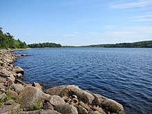
Witherod Lake, the third-largest water body in the park
816:
Long Lake Provincial Park Draft Park Management Plan
550:
by a private company. Resourcetec Inc. was hired by
146:, Canada. It was initiated in 1981 by then Premier
1531:
1436:
989:
961:
118:
110:
95:
87:
77:
67:
21:
1159:Grand-Pré & Grand-Pré Rural Historic District
1074:Cast Iron Façade / Coomb's Old English Shoe Store
187:Long Lake is a provincial park controlled by the
710:"Miles and miles of land, but not enough parks"
325:Long Lake Provincial Park in the spring of 2016
691:"What will happen to Halifax watershed lands?"
189:Department of Natural Resources and Renewables
836:
8:
391:at the north end of Spruce Hill Lake, where
1368:St. George's Anglican Church / Round Church
1578:Waverley–Salmon River Long Lake Wilderness
843:
829:
821:
18:
201:Mountain Bike Management Plan Submission
644:
1313:Pictou Railway Station (Intercolonial)
1269:Marconi & Marconi Wireless Station
763:Woodbury, Richard (16 November 2016).
658:
656:
654:
652:
650:
648:
811:Long Lake Provincial Park Association
7:
1615:
1548:Eigg Mountain–James River Wilderness
1303:Old Town Lunenburg Historic District
1039:Argyle Township Court House and Jail
66:
806:Randy Gray's website about the park
801:HalifaxTrails.ca – Long Lake guide
239:Southern shoreline of Witherod Lake
349:Child and dog playing in Long Lake
14:
1029:Annapolis Royal Historic District
784:Canadian Broadcasting Corporation
575:(oak, beech, witch hazel, birch,
1627:
1614:
1603:
1602:
778:Palmeter, Paul (22 April 2016).
689:Mitchell, Blair (21 July 1976).
114:Department of Lands and Forestry
76:
50:
43:
33:Map of Long Lake Provincial Park
27:
1701:Provincial parks of Nova Scotia
1568:Spectacle Island Game Sanctuary
109:
86:
1543:Blue Mountain-Birch Cove Lakes
1358:Sir Frederick Borden Residence
852:Protected areas of Nova Scotia
708:Lamey, Joanne (21 July 1976).
1:
1696:Parks in Halifax, Nova Scotia
1353:Sinclair Inn / Farmer's Hotel
1254:Little Dutch (Deutsch) Church
1209:Halifax WWII Coastal Defences
1034:Antigonish County Court House
999:Acacia Grove / Prescott House
933:Region of Queens Municipality
1398:Sydney WWII Coastal Defences
1293:Old Barrington Meeting House
1204:Halifax Waterfront Buildings
1024:Annapolis County Court House
251:Dunbrack Street between the
91:2,095 hectares (5,180 acres)
730:. Government of Nova Scotia
534:Bayers Lake Industrial Park
125:bus routes 22, 24, 123, 127
1717:
1563:Scatarie Island Wilderness
1383:St. Paul's Anglican Church
1373:St. John's Anglican Church
1348:Sainte-Anne / Port Dauphin
1139:Fort Sainte Marie de Grace
223:Location and access points
1675:Long Lake Provincial Park
1664:44.6174694°N 63.6352861°W
1598:
1104:Debert Palaeo-Indian Site
858:
193:Government of Nova Scotia
140:Long Lake Provincial Park
99:October 9, 1984
38:
26:
22:Long Lake Provincial Park
1573:Tobeatic Wilderness Area
1413:Truro Old Normal College
567:in the 1960s, extensive
509:Environmental challenges
1669:44.6174694; -63.6352861
1408:Trinity Anglican Church
1288:Nova Scotia Coal Fields
991:National historic sites
59:Location in Nova Scotia
16:Park in Halifax, Canada
1553:Liscomb Game Sanctuary
1363:Springhill Coal Mining
1229:Jonathan McCully House
1199:Halifax Public Gardens
1144:Fortress of Louisbourg
1099:D'Anville's Encampment
605:
358:
357:Long Lake in fall 2012
350:
326:
240:
232:
136:
1583:White Lake Wilderness
1533:Provincial wilderness
1328:Prince of Wales Tower
1019:Alexander Graham Bell
971:Cape Breton Highlands
603:
356:
348:
324:
238:
230:
134:
119:Public transit access
981:Sable Island Reserve
541:all-terrain vehicles
417:, paddle boards and
399:Cross-country skiers
144:Halifax, Nova Scotia
82:Halifax, Nova Scotia
1659: /
1558:Panuke Lake Reserve
1378:St. Mary's Basilica
1274:Melanson Settlement
1259:Liverpool Town Hall
1244:Knaut–Rhuland House
1224:Hydrostone District
1184:Halifax Court House
1049:Bedford Petroglyphs
552:Dexter Construction
1535:areas & others
1298:Old Burying Ground
1169:Grassy Island Fort
1094:Covenaters' Church
1059:Black-Binney House
1054:Beinn Bhreagh Hall
898:Guysborough County
606:
359:
351:
327:
241:
233:
137:
1642:
1641:
1634:Canada portal
1418:Truro Post Office
1264:Lunenburg Academy
1179:Halifax City Hall
888:Cumberland County
883:Colchester County
873:Antigonish County
451:Off-road vehicles
129:
128:
1708:
1683:
1682:
1680:
1679:
1678:
1676:
1671:
1670:
1665:
1660:
1657:
1656:
1655:
1652:
1632:
1631:
1630:
1618:
1617:
1606:
1605:
1496:MacCormack Beach
1438:Provincial parks
1393:St. Peters Canal
1283:Deadman's Island
1249:Ladies' Seminary
1194:Halifax Dockyard
1154:Government House
943:Shelburne County
923:Lunenburg County
913:Inverness County
868:Annapolis County
845:
838:
831:
822:
788:
787:
775:
769:
768:
760:
754:
753:
746:
740:
739:
737:
735:
724:
718:
717:
705:
699:
698:
686:
680:
677:
671:
670:
668:
660:
532:from the nearby
306:Water Commission
177:Order in Council
106:
104:
54:
53:
47:
31:
19:
1716:
1715:
1711:
1710:
1709:
1707:
1706:
1705:
1686:
1685:
1674:
1672:
1668:
1666:
1662:
1661:
1658:
1653:
1650:
1648:
1646:
1645:
1643:
1638:
1628:
1626:
1594:
1534:
1527:
1516:Uisge Ban Falls
1511:Smuggler's Cove
1432:
1423:Wolfe's Landing
1403:Thinkers' Lodge
1279:Melville Island
1189:Halifax Armoury
1174:Halifax Citadel
1164:Granville Block
1004:Admiralty House
985:
957:
953:Yarmouth County
948:Victoria County
938:Richmond County
854:
849:
797:
792:
791:
777:
776:
772:
762:
761:
757:
748:
747:
743:
733:
731:
726:
725:
721:
707:
706:
702:
688:
687:
683:
678:
674:
666:
662:
661:
646:
641:
598:
561:
559:Flora and fauna
511:
488:In addition to
366:Mountain bikers
343:
319:
245:Dunbrack Street
225:
185:
157:
123:Halifax Transit
111:Managed by
102:
100:
72:Provincial park
63:
62:
61:
60:
57:
56:
55:
34:
17:
12:
11:
5:
1714:
1712:
1704:
1703:
1698:
1688:
1687:
1640:
1639:
1637:
1636:
1624:
1612:
1599:
1596:
1595:
1593:
1592:
1585:
1580:
1575:
1570:
1565:
1560:
1555:
1550:
1545:
1539:
1537:
1529:
1528:
1526:
1525:
1518:
1513:
1508:
1503:
1501:Melmerby Beach
1498:
1493:
1488:
1486:Lennox Passage
1483:
1481:Jerry Lawrence
1478:
1473:
1468:
1466:Cape Chignecto
1463:
1461:Cabots Landing
1458:
1453:
1448:
1442:
1440:
1434:
1433:
1431:
1430:
1425:
1420:
1415:
1410:
1405:
1400:
1395:
1390:
1385:
1380:
1375:
1370:
1365:
1360:
1355:
1350:
1345:
1340:
1335:
1333:Province House
1330:
1325:
1320:
1315:
1310:
1308:Pictou Academy
1305:
1300:
1295:
1290:
1285:
1276:
1271:
1266:
1261:
1256:
1251:
1246:
1241:
1239:King's College
1236:
1231:
1226:
1221:
1219:HMCS Sackville
1216:
1211:
1206:
1201:
1196:
1191:
1186:
1181:
1176:
1171:
1166:
1161:
1156:
1151:
1149:Georges Island
1146:
1141:
1136:
1134:Fort St. Louis
1131:
1126:
1121:
1116:
1111:
1106:
1101:
1096:
1091:
1086:
1081:
1076:
1071:
1066:
1061:
1056:
1051:
1046:
1041:
1036:
1031:
1026:
1021:
1016:
1011:
1006:
1001:
995:
993:
987:
986:
984:
983:
978:
973:
967:
965:
963:National parks
959:
958:
956:
955:
950:
945:
940:
935:
930:
925:
920:
915:
910:
905:
900:
895:
890:
885:
880:
878:Cape Breton RM
875:
870:
865:
859:
856:
855:
850:
848:
847:
840:
833:
825:
819:
818:
813:
808:
803:
796:
795:External links
793:
790:
789:
770:
755:
741:
719:
714:The 4th Estate
700:
695:The 4th Estate
681:
672:
643:
642:
640:
637:
636:
635:
627:
623:
620:
617:
597:
594:
560:
557:
515:Hurricane Juan
510:
507:
506:
505:
502:
499:
493:
486:
474:
471:
464:
458:
454:
444:
443:
439:
432:
422:
411:
408:
402:
396:
395:children swim.
379:
375:
369:
342:
339:
318:
315:
302:
301:
298:
295:
292:
285:
282:
279:
276:
273:
270:
263:
262:
259:
256:
224:
221:
184:
181:
156:
153:
142:is located in
127:
126:
120:
116:
115:
112:
108:
107:
97:
93:
92:
89:
85:
84:
79:
75:
74:
69:
65:
64:
58:
49:
48:
42:
41:
40:
39:
36:
35:
32:
24:
23:
15:
13:
10:
9:
6:
4:
3:
2:
1713:
1702:
1699:
1697:
1694:
1693:
1691:
1684:
1681:
1635:
1625:
1623:
1622:
1613:
1611:
1610:
1601:
1600:
1597:
1591:
1590:
1586:
1584:
1581:
1579:
1576:
1574:
1571:
1569:
1566:
1564:
1561:
1559:
1556:
1554:
1551:
1549:
1546:
1544:
1541:
1540:
1538:
1536:
1530:
1524:
1523:
1519:
1517:
1514:
1512:
1509:
1507:
1504:
1502:
1499:
1497:
1494:
1492:
1489:
1487:
1484:
1482:
1479:
1477:
1474:
1472:
1469:
1467:
1464:
1462:
1459:
1457:
1454:
1452:
1449:
1447:
1444:
1443:
1441:
1439:
1435:
1429:
1426:
1424:
1421:
1419:
1416:
1414:
1411:
1409:
1406:
1404:
1401:
1399:
1396:
1394:
1391:
1389:
1386:
1384:
1381:
1379:
1376:
1374:
1371:
1369:
1366:
1364:
1361:
1359:
1356:
1354:
1351:
1349:
1346:
1344:
1341:
1339:
1338:Royal Battery
1336:
1334:
1331:
1329:
1326:
1324:
1321:
1319:
1316:
1314:
1311:
1309:
1306:
1304:
1301:
1299:
1296:
1294:
1291:
1289:
1286:
1284:
1280:
1277:
1275:
1272:
1270:
1267:
1265:
1262:
1260:
1257:
1255:
1252:
1250:
1247:
1245:
1242:
1240:
1237:
1235:
1232:
1230:
1227:
1225:
1222:
1220:
1217:
1215:
1212:
1210:
1207:
1205:
1202:
1200:
1197:
1195:
1192:
1190:
1187:
1185:
1182:
1180:
1177:
1175:
1172:
1170:
1167:
1165:
1162:
1160:
1157:
1155:
1152:
1150:
1147:
1145:
1142:
1140:
1137:
1135:
1132:
1130:
1127:
1125:
1124:Fort Lawrence
1122:
1120:
1117:
1115:
1112:
1110:
1107:
1105:
1102:
1100:
1097:
1095:
1092:
1090:
1087:
1085:
1084:Chapman House
1082:
1080:
1079:Chapel Island
1077:
1075:
1072:
1070:
1069:Canso Islands
1067:
1065:
1062:
1060:
1057:
1055:
1052:
1050:
1047:
1045:
1042:
1040:
1037:
1035:
1032:
1030:
1027:
1025:
1022:
1020:
1017:
1015:
1012:
1010:
1007:
1005:
1002:
1000:
997:
996:
994:
992:
988:
982:
979:
977:
974:
972:
969:
968:
966:
964:
960:
954:
951:
949:
946:
944:
941:
939:
936:
934:
931:
929:
928:Pictou County
926:
924:
921:
919:
916:
914:
911:
909:
906:
904:
901:
899:
896:
894:
891:
889:
886:
884:
881:
879:
876:
874:
871:
869:
866:
864:
861:
860:
857:
853:
846:
841:
839:
834:
832:
827:
826:
823:
817:
814:
812:
809:
807:
804:
802:
799:
798:
794:
785:
781:
774:
771:
766:
759:
756:
751:
745:
742:
729:
723:
720:
716:. p. 10.
715:
711:
704:
701:
696:
692:
685:
682:
676:
673:
665:
659:
657:
655:
653:
651:
649:
645:
638:
632:
628:
624:
621:
618:
615:
611:
610:
609:
602:
595:
593:
589:
587:
582:
581:boreal forest
578:
574:
570:
566:
558:
556:
553:
549:
544:
542:
537:
535:
531:
526:
524:
519:
516:
508:
503:
500:
497:
494:
491:
487:
484:
480:
475:
472:
469:
465:
462:
459:
455:
452:
449:
448:
447:
440:
437:
433:
430:
426:
423:
420:
416:
412:
409:
406:
403:
400:
397:
394:
393:Harrietsfield
390:
385:
380:
376:
373:
370:
367:
364:
363:
362:
355:
347:
340:
338:
335:
331:
323:
316:
314:
310:
307:
299:
296:
293:
290:
286:
283:
280:
277:
274:
271:
268:
267:
266:
260:
257:
254:
250:
249:
248:
246:
237:
229:
222:
220:
217:
213:
209:
204:
202:
196:
194:
190:
182:
180:
178:
172:
169:
165:
162:
154:
152:
149:
148:John Buchanan
145:
141:
133:
124:
121:
117:
113:
98:
94:
90:
83:
80:
73:
70:
46:
37:
30:
25:
20:
1654:63°38′7.03″W
1651:44°37′2.89″N
1644:
1619:
1607:
1587:
1520:
1490:
1428:York Redoubt
1089:Charles Fort
1064:Bloody Creek
918:Kings County
908:Hants County
893:Digby County
773:
758:
744:
732:. Retrieved
722:
713:
703:
697:. p. 2.
694:
684:
675:
607:
590:
562:
545:
538:
527:
520:
512:
466:Camping and
445:
425:Birdwatchers
360:
336:
332:
328:
311:
303:
264:
242:
208:conservation
205:
197:
186:
173:
170:
166:
158:
139:
138:
1667: /
1476:Dollar Lake
1388:St. Peter's
1214:Henry House
1119:Fort Edward
1014:Akins House
767:. CBC News.
457:maintained.
429:naturalists
413:Boaters in
96:Established
1690:Categories
1673: (
1506:Mira River
1471:Dalem Lake
1323:Port-Royal
1234:Kejimkujik
1129:Fort McNab
1044:Beaubassin
1009:Africville
976:Kejimkujik
903:Halifax RM
639:References
565:Boy Scouts
427:and other
405:Geocaching
341:Park usage
183:Management
103:1984-10-09
1491:Long Lake
1343:SS Acadia
1114:Fort Anne
631:Earth Day
614:Spryfield
577:red maple
496:Marijuana
468:squatting
384:waterfall
317:Hydrology
253:Spryfield
135:Long Lake
1609:Category
1456:Blomidon
1451:Ben Eoin
1109:Fernwood
573:hardwood
548:clearcut
461:Trapping
436:erratics
289:Goodwood
161:quarries
78:Location
1621:Commons
1589:more...
1522:more...
1446:Arisaig
1318:Pier 21
634:Street.
586:orchids
569:barrens
523:erosion
483:alcohol
216:erosion
191:of the
155:History
101: (
1281:&
734:May 2,
596:Trails
530:runoff
490:litter
479:Litter
442:kinds.
419:canoes
415:kayaks
372:Hikers
212:resort
667:(PDF)
863:CRHP
736:2012
287:the
88:Area
68:Type
389:dam
1692::
782:.
712:.
693:.
647:^
1677:)
844:e
837:t
830:v
786:.
752:.
738:.
105:)
Text is available under the Creative Commons Attribution-ShareAlike License. Additional terms may apply.