1222:
1036:
1015:£14,000, in return for all the tolls. A year later, they tried to raise £12,000 in transferable shares of £100 each, but the uptake was slow. By 13 February 1765, the full amount had been subscribed, and Grundy was engaged as Chief Engineer at a salary of £300 per year. He employed James Hogard as resident engineer, and work began in March. By mid-1767, the outfall sluice and lock at Tetney Haven had been completed, as had the first 7 miles (11 km) of cut. The cut was of sufficient depth that water levels were around 2 feet (0.6 m) below the land surface, so that the navigation could act as a land drain as well as a canal. The first 5 miles (8 km) from Tetney Haven to Fire Beacon Lane were opened in May 1767. Hogard then took over from Grundy as Chief Engineer, at a salary of £140 per year, and began the construction of the final section including seven locks. Additional subscriptions had to be found to fund the work, but the navigation reached Riverhead basin at Louth, and a formal opening was held in May 1770. The total cost was £27,500.
1019:
through a 4-foot (1.2 m) diameter culvert, which passed under a stables and granary to reach the basin. Initially, the commercial community around
Riverhead was separate from the main centre of population in Louth, but after the coming of the railway, ribbon development resulted in the two areas being connected. Six of the eight locks were built in an unusual way with the sides of the lock chambers consisting of four elliptical bays, to help them resist soil movement in the surrounding ground. It is not known which of the engineers involved in the construction designed the locks, which are rare in Britain. The two other locks had conventional straight walls. The locks were not built to a standard size, varying in length between 86 and 100 feet (26 and 30 m) and in width between 15.25 and 19 feet (4.65 and 5.79 m), although all had a depth of 5.33 feet (1.62 m) over the sill, to cater for the
1007:
1032:
contribute a maximum of £500 per year towards maintenance costs. If more than £500 was needed, the commissioners were to supply any additional amounts. Although
Chaplin had an option to renew the lease after 7 years, he did not do so, and no other takers could be found. The commissioners then negotiated with Chaplin, and revised terms were agreed. In return for a 99-year lease, he would fund all repairs, pay the salaries of the officers of the canal, and pay 5 per cent interest to the subscribers. Clearly, the 99-year lease was not authorised by the enabling act, but nobody challenged its legality for over 50 years. Chaplin was not thorough in carrying out his side of the bargain and had to be reminded that he had not been paying the interest in 1782 and again in 1788.
1311:
1158:(GNR) obtained another act of Parliament allowing them to purchase or lease the East Lincolnshire Railway and Canal. They held it for the remaining 29 years, as a tactical move to prevent opposition from the existing leaseholders. When the lease came to an end, the General Manager of the GNR reported that they had kept the tolls as high as was legally possible, but suggested that they refrain from renewing the lease. The commissioners were unable to find anyone wanting to bid for the tolls, and collected them themselves until a bidder was found three months later. Although the tolls were lower than they had been under railway ownership, income was satisfactory into the early 1900s.
1048:
and causing flooding. Chaplin was ordered to carry out repairs but failed to do so, and died soon afterwards. His son Thomas took over, and tried to negotiate an end to the lease. On paper, this appears to have been accepted, but it is not clear that it was carried out, since George
Chaplin, the son of Thomas, paid for the navigation to be made wider and deeper in 1811, and spent another £400 on repairs in 1814. There are no records of actual tolls, but estimates suggest that they rose from around £2,000 in the 1770s to £5,000 in the 1820s. Interest payments were £1,375 per year, and Chaplin argued that it had only become a profitable enterprise for him in the 1820s.
1376:
948:
years. When the lease was due for renewal, no other takers were found, and
Chaplin was granted a 99-year lease, despite the fact that the act did not authorise such an action. He collected the tolls but failed to maintain the navigation. When complaints were received, a new act of Parliament was obtained in 1828 to alter the tolls and legalise Chaplin's long lease. The lease was transferred to two railway companies in 1847, and reverted to the commissioners in 1876. The operation was a moderate success until the beginning of the 20th century, when there was a rapid decline in income, and the canal formally closed in 1924.
1364:
1071:
1352:
1307:, dates from 1782, and was in regular use following restoration. The building replaced an earlier structure, as a water mill is known to have existed on the site since 1155. Water from the mill stream flows into Westfield Drain and returns to the canal a little further downstream. This is only possible because of the lowered water levels in the canal. Before closure to navigation, there was another inverted syphon under the canal, which returned the water to the River Lud, but this has been blocked up and abandoned.
544:
490:
282:
483:
268:
202:
1267:
open-plan, but has since been converted into offices, although most of the original features are still visible. To the east is
Jackson's Warehouse, with ten bays, two storeys and an attic. It was converted into a dwelling in 2003, which resulted in minor changes to the doors and windows, but the open-plan interior has been retained. The two buildings are complemented by the Woolpack Inn, also Grade II listed.
810:
730:
690:
510:
422:
368:
322:
302:
275:
228:
870:
612:
537:
530:
850:
830:
790:
770:
750:
710:
670:
642:
605:
598:
578:
564:
476:
456:
442:
402:
388:
348:
341:
248:
1277:, where much of the parish church dates from the twelfth and fourteenth centuries, was the site of Keddington Church Lock, although little of it remains. Ticklepenny Lock is better preserved, with four concave sections separated by timber posts. The third section is partially hidden by a twentieth century concrete bridge, which carries a minor road over the lock chamber. Nearby are the
650:
634:
571:
449:
395:
1205:
treated and fed into the public water supply. Water from the Waithe Dike supplements this, and effectively flows upstream along the canal. In summer months, the available supply is not always sufficient to meet the demand, and additional water is pumped along a 36-inch (914 mm) pipeline from the Great Eau. The pumping station is located at Cloves Bridge, to the east of
31:
3128:
999:. The length would be a little over 11 miles (18 km), and nine locks would be required along its course together with several bridges. Costs for different sizes of canal were provided, from £15,590 for a two barge canal to £10,884 for a canal suitable for lighters drawing 2 feet (0.61 m). The committee asked Grundy to accompany them to
1289:
Sandwiched between the canal and the River Lud is a sewage treatment plant. The treated effluent is discharged into the canal below the lock site. Beyond the works are
Alvingham Fisheries, and then a bridge which carries Lock Road over the canal. Alvingham Lock has two semi-circular drain openings in
1204:
which measures the flow along the canal. The water is used for three main purposes. Some water is fed back into the River Lud to maintain its ecology. Some is licensed to be abstracted for spray irrigation of crops. Large volumes are also pumped from a feeder into
Covenham Reservoir, from which it is
1196:(IDB). This was formed in November 2000, when the Louth IDB, the Alford IDB, and the Skegness District IDB amalgamated. The Lindsey Marsh IDB maintains five pumping stations which pump into the canal, and because of the lower water levels, a number of drains which discharge into the canal by gravity.
1174:
to the
Riverhead area, the terminus of the canal. The commissioners applied to the Minister of Transport, asking to be relieved of their liability to maintain the canal. In 1924, the county council and the rural district council agreed to take over maintenance of the bridges. The final annual general
1018:
At Louth, the River Lud was diverted from its original course to the north of the
Riverhead basin, and followed a new course along its south side. It supplied Bain's Water Mill, from which water discharged into the basin to maintain its level. When the mill was not in use, water levels were topped up
1266:
warehouses. To the west is
Navigation Warehouse, a rectangular building with five bays and three storeys, constructed of red brick with a pantile roof. It is little altered from when it was built in 1790. It was used to store grain and wool, which was then shipped down the navigation. It was largely
1233:
The towpath may be walked along the whole length of the canal, parts of which are in shallow water. The trust are engaged in a scheme to restore the full length of the canal by 2020. To assist in this, a feasibility study was commissioned in September 2004, and was carried out by Faber Maunsell. The
1183:
With the demise of navigation and the decay of the lock structures, water levels are considerably lower than they once were. The whole of the canal, together with parts of the old channel of the River Lud, the Black Dike, the Poulton Drain and the Waithe Dike, which feed into the Mother Drain before
1047:
There were problems with water levels in 1792. A lack of maintenance had resulted in silting, and horses were used to tow the barges, rather than them sailing along the navigation. To prevent the boats grounding, the water levels had been raised, preventing natural drainage from the surrounding land
1318:
At High Bridge, the canal turns to the north, and the River Lud continues to the north-east as the Old Eau. Outfen Lock was one of the locks constructed with straight sides. The western wall has collapsed, but the eastern wall survives. The surrounding countryside is very flat and low lying, being
1270:
Baines Flour Mill, which supplied water to the basin, is a red-brick building, dating from around 1800, with hipped pantile roofs. The main section has three storeys, and there is a two storey office range. Adjacent to the mill was the works of the Louth Gaslight Company, which were built in 1826.
1229:
The Louth Navigation Trust was formed in 1986 as a registered charity, with the primary aim of preservation, conservation and restoration of the canal and of the buildings associated with it, including the lock structures. They have carried out several projects, using voluntary labour, which have
1014:
The canal obtained its act of Parliament on 24 March 1763, but contained no proper provision for raising the capital needed to build the canal. Money could only be borrowed against the expected tolls, and this caused difficulties. On 30 May, the commissioners tried to find someone willing to lend
947:
The act did not provide the normal provisions for raising capital for the construction, as finance could only be obtained by leasing of the tolls. When completed, the commissioners leased the tolls to Charles Chaplin, who held ten shares and was also a commissioner, for an initial period of seven
1253:
The Louth Navigation, unlike many other disused canals, is in water throughout its length and has not been in-filled or built over as it is important for drainage of the surrounding land. Several formerly movable bridges have since been replaced with fixed bridges. The eight locks are in varying
1031:
The act of Parliament allowed the commissioners to lease the tolls for periods of up to seven years, and the first lease was granted to Charles Chaplin, one of the commissioners who held ten shares, in January 1770. He agreed to pay a rent of 4 per cent per year to the other shareholders, and to
1330:
Fulstow East and West pumping stations are close to Heelgate Farm. The only major road to cross the canal is the A1031, which does so at Thoresby Bridge. By the bridge is another surviving warehouse, built in 1821 with seven bays and three storeys, and Thoresby Bridge pumping station. The final
1212:
To protect the drinking water supply from contamination by salt water entering the canal through the outfall sluice, the original Tetney Lock has been replaced by a tilting weir. This is controlled automatically, and maintains a difference in level between its upstream and downstream sides. The
975:
Despite being separated from the sea by a low coastal plain, which made contact with the wider world difficult, by the 18th century Louth had become a prosperous market town with a forward-looking town corporation. Realising that a link to the North Sea would provide opportunities for trade and
1319:
crossed by numerous drainage ditches. The Black Dike enters the channel from the west. Water from Austen Fen is pumped into the canal by Austen Fen East and West pumping stations. These, and the other pumping stations that discharge into the canal are owned and operated by the Lindsey Marsh
1003:, where they would show the plans to the noblemen and gentlemen. This produced a favourable response, and with little local opposition, the pace of the project slowed. The reports were printed in September 1761, and the bill was submitted to Parliament on 6 December 1762.
1271:
Baines erected a stone to define the boundary between his land and that of the gaslight company in 1878, following a dispute over encroachment. Soon the site of the top lock is reached. This has been replaced by a tilting weir, which controls water levels in the basin.
1175:
meeting took place on 5 September 1924, and the assets of the navigation were sold on 8 October. The sale raised £6,240, of which £1,500 had to be paid to the councils towards the bridge works. The remainder was distributed to the shareholders in 1927.
967:, from which treated water enters the public water supply. Water from Waithe Dike supplements the supply, effectively flowing upstream along the canal, and when required, additional water is pumped into the canal along a pipeline from the Great Eau.
1285:
abbey dating from 1139. Willows Lock is also reasonably well preserved, and is of a similar construction to Ticklepenny Lock, as is Salter Fen Lock, although it differs in having a large opening which acts as an overflow in the south-eastern side.
1230:
included maintenance of Ticklepenny lock and clearance work on the towpath. They are based at the Navigation Warehouse at Riverhead, Louth, which they helped to restore to a high standard in 1998/9, in partnership with Groundwork Lincolnshire.
1302:
Water Mill from the canal. The present building was constructed in 1782 by John Maddison, with extensions in 1900, and it was restored in 1972. Most of the machinery, including an 11-foot (3.4 m) diameter breast shot
1199:
Most of the flow from the River Lud is fed into the canal, and the Environment Agency maintain a tilting weir at the site of the original Top Lock. This controls water levels in the Riverhead Basin, and also includes a
1335:, but nothing remains of it. It has been replaced by a sluice with rising sector gates. The final section is now protected from high sea levels by an outfall sluice at Tetney Haven, with two sets of pointed doors.
1323:. The canal continues past Canal Farm and under Fen Bridge. On the east bank is a nineteenth century nine-bayed warehouse with three storeys and an attic. Biergate East and West pumping stations are situated near
3203:
1129:
Users of the canal felt that the tolls, which had not altered since 1770, were too high, as the volume of traffic using the navigation had increased. To rectify the situation, a new act of Parliament, the
995:
In August, Smeaton reviewed Grundy's plans, which was for a river navigation. Cuts would be made to straighten the River Lud, and a sea sluice and lock would be provided where the river joined the
1327:, constructed in the 1960s to supply drinking water. The works to treat the water is near Fire Beacon Farm and bridge, the temporary terminus of the opened waterway during construction.
3196:
1298:, and is Grade I listed. In the same churchyard is the parish church of St Adelwold, also Grade I listed, and built in the 13th, 15th and 16th centuries. The churches separate
1924:
1465:
3189:
1618:
2288:
2027:
1873:
1771:
1567:
1720:
1822:
1669:
1516:
1290:
its western wall, and an inverted syphon carries water from the River Lud under the lock, to feed the mill pond for Alvingham Mill. The canal then passes the
1088:
An Act for improving and maintaining the Navigation from the River Humber to Altringham in the County of Lincoln, and from thence to Louth in the same County.
1975:
988:
to carry out the survey. Smeaton advised caution, suggesting that they obtained the consent of as many landowners as possible before proceeding with a
980:
to survey a route. He suggested a route from Louth to Tetney Haven, and on 28 January 1760, subscriptions were invited to pay for a full survey and an
165:
2127:
3152:
1221:
1147:
3691:
1291:
1093:
1006:
3537:
2166:
2147:
2109:
1363:
1375:
1192:. The land drainage functions for the low-lying land surrounding the lower reaches of the canal are the responsibility of the Lindsey Marsh
3609:
2415:
3382:
2086:
1035:
3671:
3075:
3012:
2941:
2910:
2879:
2830:
2785:
2754:
2714:
2683:
2638:
2581:
2550:
2519:
1213:
difference is between 6 and 8 inches (15 and 20 cm) in winter, rising to between 16 and 18 inches (40 and 45 cm) in summer.
1351:
3070:
3007:
2936:
2905:
2874:
2825:
2780:
2749:
2709:
2678:
2633:
2576:
2545:
2514:
1075:
3676:
3487:
1294:, once the chapel for a Gilbertine Priory, which dates from the eleventh to fourteenth centuries. It was the parish church for
3052:
1262:
The navigation begins at a large basin near the centre of Louth, which runs in a north-easterly direction. At the end are two
3681:
1155:
2280:
3402:
1450:
1310:
158:
944:
were required to overcome the difference in altitude, six of which were constructed with sides consisting of four bays.
3686:
3417:
3213:
1239:
2856:
1143:
3650:
3517:
1235:
3132:
1340:
3502:
3477:
3407:
1399:
3322:
183:
3472:
3367:
1142:. c. xxx) was obtained in 1828, which reduced the tolls and formalised the 99-year lease of 1777. In 1847, the
151:
1170:
killed what traffic was left. Income for 1916 was only £66. The final blow was the devastation caused by the
951:
Because the canal was also a land drainage channel, it was not subject to infilling, and is now a designated
2081:
1320:
1193:
960:
2433:
3257:
2120:
1121:
1209:
All Saints, and the 6.8-mile (11 km) pipeline empties into the canal below the site of Outfen Lock.
1154:
c. cxiii) which allowed them to purchase the lease of the Louth Navigation, and later the same year, the
3462:
3422:
3317:
3307:
1443:
1083:
1426:
3645:
3604:
3452:
3362:
1421:
3594:
3507:
1171:
989:
917:
127:
3342:
3327:
1416:
1324:
1295:
1254:
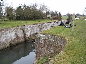
states of repair; two have been obliterated, while Alvingham lock is the best surviving example.
1189:
1000:
964:
956:
3437:
3578:
3377:
3347:
3337:
3332:
3297:
3181:
2411:
2162:
2159:
A Biographical Dictionary of Civil Engineers in Great Britain and Ireland: Vol 1: 1500 to 1830
2143:
2105:
981:
933:
909:
3624:
3614:
3497:
3492:
3392:
3372:
3262:
3066:
3003:
2932:
2901:
2870:
2821:
2776:
2745:
2705:
2674:
2629:
2572:
2541:
2510:
1151:
3573:
3557:
3542:
3532:
3522:
3482:
3352:
3252:
1263:
1167:
977:
937:
1166:
The early years of the 20th century saw a rapid decline in the use of the canal and the
3640:
3619:
3599:
3547:
3512:
3427:
3282:
3272:
3267:
3247:
3139:
1278:
210:
3665:
3552:
3442:
3357:
3302:
3277:
3242:
3237:
3227:
1247:
3527:
3432:
3387:
3048:
1243:
1111:
985:
925:
921:
137:
3467:
3397:
3312:
3287:
1411:
1304:
1282:
1206:
1201:
1020:
984:. The fund soon reached £850, and on 18 February 1760 the town clerk approached
3457:
3292:
1274:
1185:
952:
941:
36:
3167:
3154:
2043:
2029:
1991:
1977:
1940:
1926:
1889:
1875:
1838:
1824:
1787:
1773:
1736:
1722:
1685:
1671:
1634:
1620:
1583:
1569:
1532:
1518:
1481:
1467:
3447:
3232:
3111:
3097:
3034:
2989:
2975:
2852:
2807:
2660:
2615:
1299:
1040:
913:
214:
30:
3127:
144:
1139:
1098:
1332:
1010:
Firebeacon Bridge, the terminus of the initial section opened in 1767
996:
936:
in 1763 and completed in 1770, under the supervision of the engineer
929:
2469:
2467:
1309:
1220:
1034:
1005:
1341:
Selection of photographs from the collection on Wikimedia Commons
1314:
The Navigation warehouse at Austen Fen, built in the 19th century
1234:
costs of the study were shared by the trust, Louth Town Council,
3144:
3185:
2429:
1148:
East Lincolnshire Railway (Louth Navigation Purchase) Act 1847
959:
that drains the surrounding land managed by the Lindsey Marsh
2239:
2237:
992:, as opposition in Parliament could be difficult to counter.
976:
expansion, in October 1756 they commissioned the engineer
2224:
2222:
1225:
Alvingham lock, the best preserved of the surviving locks
3633:
3587:
3566:
3220:
3049:"Covenham St. Bartholomew & the Reservoir Walk"
1120:
1110:
1105:
1092:
1082:
1056:
133:
123:
118:
110:
102:
94:
86:
78:
70:
65:
57:
49:
44:
23:
2140:People & Boats – A History of the Louth Canal
2962:
2826:"Alvingham Lock and inverted syphon (1063080)"
2497:
2485:
2473:
2458:
2446:
3197:
2281:"Ice damage threatens historic lock's future"
159:
8:
2393:
2381:
2369:
2357:
2345:
2333:
2321:
2243:
2213:
2201:
2189:
3204:
3190:
3182:
2602:
2309:
2267:
2255:
2138:Sizer, Stuart M; Clark, Josephine (2006).
1436:
1053:
191:
166:
152:
20:
2875:"Church of St Mary, Abbey Lane (1261895)"
2808:"Sewage plant outfall at Salter Fen Lock"
2406:
2404:
2402:
916:. It ran for 11 miles (18 km) from
3071:"Warehouse at Thoresby Bridge (1168140)"
2228:
2157:Skempton, Sir Alec; et al. (2002).
2418:from the original on 13 September 2014.
2182:
1347:
641:
633:
149:
3055:from the original on 29 December 2020.
2436:from the original on 29 December 2020.
1184:it joins the canal, are designated as
3538:Thorne and Hatfield Moors Peat Canals
3145:website of the Louth Navigation Trust
2121:"Restoration of the Louth Navigation"
2100:Boyes, John; Russell, Ronald (1977).
1122:Text of statute as originally enacted
1023:and sloops that used the navigation.
7:
3610:Glasgow, Paisley and Johnstone Canal
1188:, and are the responsibility of the
838:Keddington Church Lock (remains of)
3383:Ivelchester and Langport Navigation
2990:"Pumping station and access bridge"
2087:History of the British canal system
543:
489:
482:
281:
267:
3076:National Heritage List for England
3013:National Heritage List for England
2942:National Heritage List for England
2911:National Heritage List for England
2880:National Heritage List for England
2859:from the original on 9 April 2017.
2831:National Heritage List for England
2786:National Heritage List for England
2755:National Heritage List for England
2735:Ordnance Survey 1:25,000 map, 2014
2715:National Heritage List for England
2684:National Heritage List for England
2639:National Heritage List for England
2582:National Heritage List for England
2551:National Heritage List for England
2520:National Heritage List for England
2133:from the original on 4 March 2016.
809:
729:
689:
509:
421:
367:
321:
301:
14:
2906:"Church of St Adelwold (1063076)"
2634:"Church of St Margaret (1359987)"
2291:from the original on 6 March 2016
1144:East Lincolnshire Railway Company
940:and then by James Hoggard. Eight
274:
227:
201:
3126:
2515:"Navigation Warehouse (1240242)"
2020:
1968:
1917:
1866:
1815:
1764:
1713:
1662:
1611:
1560:
1509:
1458:
1374:
1362:
1350:
1076:Parliament of the United Kingdom
1069:
869:
868:
858:Tilting weir (site of Top lock)
848:
828:
808:
798:Ticklepenny's Lock (remains of)
788:
768:
748:
728:
708:
688:
668:
648:
640:
632:
611:
610:
603:
596:
576:
569:
562:
542:
536:
535:
529:
528:
508:
488:
481:
474:
454:
447:
440:
420:
400:
393:
386:
366:
346:
339:
320:
300:
280:
273:
266:
246:
226:
200:
29:
3488:Salisbury and Southampton Canal
3214:waterways of the United Kingdom
3035:"Biergate West pumping station"
2937:"Alvingham Watermill (1063077)"
2546:"Jackson's Warehouse (1261127)"
2432:. Water Management Consortium.
849:
829:
789:
769:
749:
709:
669:
604:
597:
577:
563:
475:
455:
441:
401:
387:
347:
340:
247:
3692:1770 establishments in England
2430:"Lindsey Marsh Drainage Board"
1156:Great Northern Railway Company
649:
586:Austen Fen E + W Pumping Stns
570:
552:Covenham Reservoir and feeder
448:
394:
1:
3403:Liskeard and Looe Union Canal
2853:"Alvingham Water Mill Tunnel"
2710:"Louth Abbey Ruins (1063050)"
2577:"Baines Flour Mill (1078197)"
2102:The Canals of Eastern England
758:Salter Fen Lock (remains of)
290:Mother Drain and flood doors
3418:Mersey and Irwell Navigation
2679:"Ticklepenny Lock (1063048)"
1240:Inland Waterways Association
718:Alvingham Lock (remains of)
464:Biergate E + W Pumping Stns
356:Thoresby Bridge Pumping Stn
236:Tetney Haven outfall sluice
3651:Kidwelly and Llanelly Canal
3518:Stourbridge Extension Canal
2781:"Salter Fen Lock (1063081)"
2616:"Tilting weir, Louth Canal"
1427:GPX (secondary coordinates)
1331:straight sided lock was at
1236:Lincolnshire County Council
778:Willow's Lock (remains of)
410:Fulstow E + W Pumping Stns
3708:
3478:Runcorn to Latchford Canal
3408:London to Portsmouth canal
2855:. Louth Navigation Trust.
2142:. Louth Navigation Trust.
2126:. Louth Navigation Trust.
1051:United Kingdom legislation
678:Out Fen Lock (remains of)
16:Canalised river in England
3672:Geography of Lincolnshire
3323:Dorset and Somerset Canal
3140:Louth Navigation Articles
1447:(Links to map resources)
1422:GPX (primary coordinates)
1397:Map all coordinates using
1357:Aerial View at Austen Fen
1134:Louth Navigation Act 1828
1068:
1063:
1058:Louth Navigation Act 1828
877:
862:
857:
842:
837:
822:
817:
802:
797:
782:
777:
762:
757:
742:
737:
722:
717:
702:
697:
682:
677:
662:
657:
624:
619:
590:
585:
556:
551:
522:
517:
502:
498:Poulton Drain and tunnel
497:
468:
463:
434:
429:
414:
409:
380:
375:
360:
355:
333:
329:
314:
309:
294:
289:
260:
255:
240:
235:
220:
209:
194:
28:
3473:Runcorn and Weston Canal
3368:Hollingwood Common Canal
2750:"Willows Lock (1063049)"
2394:Boyes & Russell 1977
2382:Boyes & Russell 1977
2370:Boyes & Russell 1977
2358:Boyes & Russell 1977
2346:Boyes & Russell 1977
2334:Boyes & Russell 1977
2322:Boyes & Russell 1977
2287:. BBC. 20 January 2011.
2244:Boyes & Russell 1977
2214:Boyes & Russell 1977
2202:Boyes & Russell 1977
2190:Boyes & Russell 1977
1405:Download coordinates as:
1281:ruins of Louth Abbey, a
963:. It is as a feeder for
658:Pipeline from Great Eau
3503:Sir John Glynne's Canal
3112:"Tetney Outfall Sluice"
2119:Faber Maunsell (2005).
2082:Canals of Great Britain
1919:Keddington Church Lock
1321:Internal Drainage Board
1194:Internal Drainage Board
961:Internal Drainage Board
932:. It was authorised by
3677:Canals in Lincolnshire
3258:Beat Bank Branch Canal
2603:Sizer & Clark 2006
2310:Sizer & Clark 2006
2268:Sizer & Clark 2006
2256:Sizer & Clark 2006
1952:Keddington Church Lock
1460:Tetney Outfall Sluice
1315:
1246:District Council, and
1226:
1217:Louth Navigation Trust
1044:
1011:
928:, at the mouth of the
376:A1031 Thoresby Bridge
3682:Canals opened in 1770
3463:Rochdale Branch Canal
3423:Newport Pagnell Canal
3318:Donnington Wood Canal
3308:Dearne and Dove Canal
3135:at Wikimedia Commons
3008:"Warehouse (1063112)"
2414:. Lindsey Marsh IDB.
2104:. David and Charles.
1493:Tetney Outfall Sluice
1417:GPX (all coordinates)
1313:
1224:
1038:
1009:
3646:Glamorganshire Canal
3605:Forth and Cart Canal
3453:River Sow Navigation
3363:Heywood Branch Canal
818:Cowslip Lane bridge
3687:Louth, Lincolnshire
3595:Aberdeenshire Canal
3508:Somerset Coal Canal
3164: /
3051:. Walking Britain.
2963:Faber Maunsell 2005
2498:Faber Maunsell 2005
2486:Faber Maunsell 2005
2474:Faber Maunsell 2005
2459:Faber Maunsell 2005
2447:Faber Maunsell 2005
2396:, pp. 314–315.
2372:, pp. 310–311.
2360:, pp. 309–310.
2348:, pp. 308–309.
2324:, pp. 307–308.
2216:, pp. 306–307.
2204:, pp. 305–306.
2192:, pp. 304–305.
2039: /
1987: /
1936: /
1885: /
1834: /
1783: /
1732: /
1681: /
1630: /
1613:Fire Beacon Bridge
1579: /
1528: /
1477: /
1172:Louth flood of 1920
310:Tetney lock bridge
256:Tetney lock sluice
3343:Grand Surrey Canal
3328:Douglas Navigation
3168:53.4527°N 0.0363°E
3098:"Tetney Lock Weir"
2161:. Thomas Telford.
2044:53.3716°N 0.0089°E
1992:53.3733°N 0.0126°E
1941:53.3759°N 0.0212°E
1890:53.3799°N 0.0285°E
1839:53.3843°N 0.0325°E
1788:53.3921°N 0.0413°E
1737:53.3973°N 0.0518°E
1686:53.4139°N 0.0665°E
1646:Fire Beacon Bridge
1635:53.4527°N 0.0362°E
1584:53.4773°N 0.0114°E
1533:53.4988°N 0.0218°E
1482:53.5079°N 0.0406°E
1390:Points of interest
1325:Covenham Reservoir
1316:
1296:North Cockerington
1227:
1190:Environment Agency
1045:
1012:
965:Covenham Reservoir
957:Environment Agency
430:Firebeacon bridge
71:Principal engineer
3659:
3658:
3378:Itchen Navigation
3348:Greasbrough Canal
3338:Glastonbury Canal
3298:Coombe Hill Canal
3131:Media related to
2661:"Keddington Lock"
2500:, pp. 13–14.
2476:, pp. 17–18.
2270:, pp. 35–36.
2168:978-0-7277-2939-2
2149:978-0-9536451-1-4
2111:978-0-7153-7415-3
2073:
2072:
2022:Louth River Head
1868:Ticklepenny Lock
1292:church of St Mary
1152:10 & 11 Vict.
1127:
1126:
1064:Act of Parliament
1043:is quite straight
1039:The channel near
982:act of Parliament
955:, managed by the
934:act of Parliament
902:
901:
898:
897:
878:Louth River Head
738:Lock Road bridge
143:
142:
95:Date of first use
79:Other engineer(s)
3699:
3625:Stevenston Canal
3615:Inverarnan Canal
3567:Northern Ireland
3498:Shropshire Canal
3493:Shrewsbury Canal
3413:Louth Navigation
3393:Leominster Canal
3373:Horncastle Canal
3263:Blyth Navigation
3206:
3199:
3192:
3183:
3179:
3178:
3176:
3175:
3174:
3169:
3165:
3162:
3161:
3160:
3157:
3133:Louth Navigation
3130:
3116:
3115:
3108:
3102:
3101:
3094:
3088:
3087:
3085:
3083:
3067:Historic England
3063:
3057:
3056:
3045:
3039:
3038:
3031:
3025:
3024:
3022:
3020:
3004:Historic England
3000:
2994:
2993:
2986:
2980:
2979:
2972:
2966:
2960:
2954:
2953:
2951:
2949:
2933:Historic England
2929:
2923:
2922:
2920:
2918:
2902:Historic England
2898:
2892:
2891:
2889:
2887:
2871:Historic England
2867:
2861:
2860:
2849:
2843:
2842:
2840:
2838:
2822:Historic England
2818:
2812:
2811:
2804:
2798:
2797:
2795:
2793:
2777:Historic England
2773:
2767:
2766:
2764:
2762:
2746:Historic England
2742:
2736:
2733:
2727:
2726:
2724:
2722:
2706:Historic England
2702:
2696:
2695:
2693:
2691:
2675:Historic England
2671:
2665:
2664:
2657:
2651:
2650:
2648:
2646:
2630:Historic England
2626:
2620:
2619:
2612:
2606:
2600:
2594:
2593:
2591:
2589:
2573:Historic England
2569:
2563:
2562:
2560:
2558:
2542:Historic England
2538:
2532:
2531:
2529:
2527:
2511:Historic England
2507:
2501:
2495:
2489:
2483:
2477:
2471:
2462:
2456:
2450:
2444:
2438:
2437:
2426:
2420:
2419:
2408:
2397:
2391:
2385:
2379:
2373:
2367:
2361:
2355:
2349:
2343:
2337:
2331:
2325:
2319:
2313:
2307:
2301:
2300:
2298:
2296:
2277:
2271:
2265:
2259:
2253:
2247:
2241:
2232:
2226:
2217:
2211:
2205:
2199:
2193:
2187:
2172:
2153:
2134:
2132:
2125:
2115:
2063:
2062:
2060:
2059:
2058:
2056:
2055:Louth River Head
2051:
2050:
2045:
2040:
2037:
2036:
2035:
2032:
2011:
2010:
2008:
2007:
2006:
2004:
1999:
1998:
1993:
1988:
1985:
1984:
1983:
1980:
1960:
1959:
1957:
1956:
1955:
1953:
1948:
1947:
1942:
1937:
1934:
1933:
1932:
1929:
1909:
1908:
1906:
1905:
1904:
1902:
1901:Ticklepenny Lock
1897:
1896:
1891:
1886:
1883:
1882:
1881:
1878:
1858:
1857:
1855:
1854:
1853:
1851:
1846:
1845:
1840:
1835:
1832:
1831:
1830:
1827:
1807:
1806:
1804:
1803:
1802:
1800:
1795:
1794:
1789:
1784:
1781:
1780:
1779:
1776:
1766:Salter Fen Lock
1756:
1755:
1753:
1752:
1751:
1749:
1744:
1743:
1738:
1733:
1730:
1729:
1728:
1725:
1705:
1704:
1702:
1701:
1700:
1698:
1693:
1692:
1687:
1682:
1679:
1678:
1677:
1674:
1654:
1653:
1651:
1650:
1649:
1647:
1642:
1641:
1636:
1631:
1628:
1627:
1626:
1623:
1603:
1602:
1600:
1599:
1598:
1596:
1591:
1590:
1585:
1580:
1577:
1576:
1575:
1572:
1562:Thoresby Bridge
1552:
1551:
1549:
1548:
1547:
1545:
1540:
1539:
1534:
1529:
1526:
1525:
1524:
1521:
1501:
1500:
1498:
1497:
1496:
1494:
1489:
1488:
1483:
1478:
1475:
1474:
1473:
1470:
1437:
1378:
1369:Ticklepenny Lock
1366:
1354:
1179:Present function
1136:
1135:
1073:
1072:
1059:
1054:
906:Louth Navigation
872:
871:
852:
851:
832:
831:
812:
811:
792:
791:
772:
771:
752:
751:
732:
731:
712:
711:
692:
691:
672:
671:
652:
651:
644:
643:
636:
635:
614:
613:
607:
606:
600:
599:
580:
579:
573:
572:
566:
565:
546:
545:
539:
538:
532:
531:
512:
511:
492:
491:
485:
484:
478:
477:
458:
457:
451:
450:
444:
443:
424:
423:
404:
403:
397:
396:
390:
389:
370:
369:
350:
349:
343:
342:
324:
323:
304:
303:
284:
283:
277:
276:
270:
269:
250:
249:
230:
229:
204:
203:
192:
175:Louth Navigation
168:
161:
154:
145:
33:
24:Louth Navigation
21:
3707:
3706:
3702:
3701:
3700:
3698:
3697:
3696:
3662:
3661:
3660:
3655:
3629:
3583:
3574:Broharris Canal
3562:
3558:Wombridge Canal
3543:Ulverston Canal
3533:Tavistock Canal
3523:Stockport Canal
3483:St Columb Canal
3438:Pidcock's Canal
3353:Grosvenor Canal
3253:Baybridge Canal
3216:
3210:
3173:53.4527; 0.0363
3172:
3170:
3166:
3163:
3158:
3155:
3153:
3151:
3150:
3124:
3119:
3110:
3109:
3105:
3096:
3095:
3091:
3081:
3079:
3065:
3064:
3060:
3047:
3046:
3042:
3033:
3032:
3028:
3018:
3016:
3002:
3001:
2997:
2988:
2987:
2983:
2974:
2973:
2969:
2961:
2957:
2947:
2945:
2931:
2930:
2926:
2916:
2914:
2900:
2899:
2895:
2885:
2883:
2869:
2868:
2864:
2851:
2850:
2846:
2836:
2834:
2820:
2819:
2815:
2806:
2805:
2801:
2791:
2789:
2775:
2774:
2770:
2760:
2758:
2744:
2743:
2739:
2734:
2730:
2720:
2718:
2704:
2703:
2699:
2689:
2687:
2673:
2672:
2668:
2659:
2658:
2654:
2644:
2642:
2628:
2627:
2623:
2614:
2613:
2609:
2601:
2597:
2587:
2585:
2571:
2570:
2566:
2556:
2554:
2540:
2539:
2535:
2525:
2523:
2509:
2508:
2504:
2496:
2492:
2484:
2480:
2472:
2465:
2457:
2453:
2445:
2441:
2428:
2427:
2423:
2410:
2409:
2400:
2392:
2388:
2380:
2376:
2368:
2364:
2356:
2352:
2344:
2340:
2332:
2328:
2320:
2316:
2308:
2304:
2294:
2292:
2279:
2278:
2274:
2266:
2262:
2254:
2250:
2242:
2235:
2227:
2220:
2212:
2208:
2200:
2196:
2188:
2184:
2180:
2175:
2169:
2156:
2150:
2137:
2130:
2123:
2118:
2112:
2099:
2095:
2078:
2054:
2052:
2049:53.3716; 0.0089
2048:
2046:
2042:
2041:
2038:
2033:
2030:
2028:
2026:
2025:
2002:
2000:
1997:53.3733; 0.0126
1996:
1994:
1990:
1989:
1986:
1981:
1978:
1976:
1974:
1973:
1951:
1949:
1946:53.3759; 0.0212
1945:
1943:
1939:
1938:
1935:
1930:
1927:
1925:
1923:
1922:
1900:
1898:
1895:53.3799; 0.0285
1894:
1892:
1888:
1887:
1884:
1879:
1876:
1874:
1872:
1871:
1849:
1847:
1844:53.3843; 0.0325
1843:
1841:
1837:
1836:
1833:
1828:
1825:
1823:
1821:
1820:
1799:Salter Fen Lock
1798:
1796:
1793:53.3921; 0.0413
1792:
1790:
1786:
1785:
1782:
1777:
1774:
1772:
1770:
1769:
1747:
1745:
1742:53.3973; 0.0518
1741:
1739:
1735:
1734:
1731:
1726:
1723:
1721:
1719:
1718:
1715:Alvingham Lock
1696:
1694:
1691:53.4139; 0.0665
1690:
1688:
1684:
1683:
1680:
1675:
1672:
1670:
1668:
1667:
1645:
1643:
1640:53.4527; 0.0362
1639:
1637:
1633:
1632:
1629:
1624:
1621:
1619:
1617:
1616:
1595:Thoresby Bridge
1594:
1592:
1589:53.4773; 0.0114
1588:
1586:
1582:
1581:
1578:
1573:
1570:
1568:
1566:
1565:
1543:
1541:
1538:53.4988; 0.0218
1537:
1535:
1531:
1530:
1527:
1522:
1519:
1517:
1515:
1514:
1492:
1490:
1487:53.5079; 0.0406
1486:
1484:
1480:
1479:
1476:
1471:
1468:
1466:
1464:
1463:
1446:
1435:
1434:
1433:
1432:
1431:
1392:
1387:
1386:
1385:
1382:
1379:
1370:
1367:
1358:
1355:
1344:
1343:
1264:Grade II listed
1260:
1219:
1202:gauging station
1181:
1168:First World War
1164:
1133:
1132:
1078:
1070:
1057:
1052:
1029:
978:John Grundy Jr.
973:
938:John Grundy Jr.
873:
853:
833:
813:
793:
773:
753:
733:
713:
693:
673:
653:
646:
645:
638:
637:
615:
608:
601:
581:
574:
567:
547:
540:
533:
513:
493:
486:
479:
459:
452:
445:
425:
405:
398:
391:
371:
351:
344:
325:
305:
285:
278:
271:
251:
231:
205:
186:
177:
176:
172:
40:
17:
12:
11:
5:
3705:
3703:
3695:
3694:
3689:
3684:
3679:
3674:
3664:
3663:
3657:
3656:
3654:
3653:
3648:
3643:
3641:Aberdare Canal
3637:
3635:
3631:
3630:
3628:
3627:
3622:
3620:Monkland Canal
3617:
3612:
3607:
3602:
3600:Dingwall Canal
3597:
3591:
3589:
3585:
3584:
3582:
3581:
3579:Dukart's Canal
3576:
3570:
3568:
3564:
3563:
3561:
3560:
3555:
3550:
3548:Westport Canal
3545:
3540:
3535:
3530:
3525:
3520:
3515:
3513:Stamford Canal
3510:
3505:
3500:
3495:
3490:
3485:
3480:
3475:
3470:
3465:
3460:
3455:
3450:
3445:
3440:
3435:
3430:
3428:Nutbrook Canal
3425:
3420:
3415:
3410:
3405:
3400:
3395:
3390:
3385:
3380:
3375:
3370:
3365:
3360:
3355:
3350:
3345:
3340:
3335:
3333:Galton's Canal
3330:
3325:
3320:
3315:
3310:
3305:
3300:
3295:
3290:
3285:
3283:Carlisle Canal
3280:
3275:
3273:Braunton Canal
3270:
3268:Bradford Canal
3265:
3260:
3255:
3250:
3248:Barnsley Canal
3245:
3240:
3235:
3230:
3224:
3222:
3218:
3217:
3211:
3209:
3208:
3201:
3194:
3186:
3148:
3147:
3142:
3123:
3122:External links
3120:
3118:
3117:
3103:
3089:
3058:
3040:
3026:
2995:
2981:
2976:"Out Fen Lock"
2967:
2955:
2924:
2893:
2862:
2844:
2813:
2799:
2768:
2737:
2728:
2697:
2666:
2652:
2621:
2607:
2595:
2564:
2533:
2502:
2490:
2478:
2463:
2451:
2439:
2421:
2398:
2386:
2384:, p. 311.
2374:
2362:
2350:
2338:
2336:, p. 308.
2326:
2314:
2302:
2272:
2260:
2248:
2246:, p. 307.
2233:
2231:, p. 281.
2218:
2206:
2194:
2181:
2179:
2176:
2174:
2173:
2167:
2154:
2148:
2135:
2116:
2110:
2096:
2094:
2091:
2090:
2089:
2084:
2077:
2074:
2071:
2070:
2067:
2064:
2023:
2019:
2018:
2015:
2012:
1971:
1967:
1966:
1964:
1961:
1920:
1916:
1915:
1913:
1910:
1869:
1865:
1864:
1862:
1859:
1818:
1814:
1813:
1811:
1808:
1767:
1763:
1762:
1760:
1757:
1748:Alvingham Lock
1716:
1712:
1711:
1709:
1706:
1665:
1661:
1660:
1658:
1655:
1614:
1610:
1609:
1607:
1604:
1563:
1559:
1558:
1556:
1553:
1512:
1508:
1507:
1505:
1502:
1461:
1457:
1456:
1453:
1448:
1441:
1430:
1429:
1424:
1419:
1414:
1408:
1402:
1395:
1394:
1393:
1391:
1388:
1384:
1383:
1380:
1373:
1371:
1368:
1361:
1359:
1356:
1349:
1346:
1345:
1339:
1338:
1337:
1279:Grade I listed
1259:
1256:
1218:
1215:
1180:
1177:
1163:
1160:
1125:
1124:
1118:
1117:
1114:
1108:
1107:
1103:
1102:
1096:
1090:
1089:
1086:
1080:
1079:
1074:
1066:
1065:
1061:
1060:
1050:
1028:
1025:
972:
969:
924:, England, to
900:
899:
896:
895:
893:
891:
889:
887:
885:
883:
880:
879:
876:
874:
867:
865:
863:
860:
859:
856:
854:
847:
845:
843:
840:
839:
836:
834:
827:
825:
823:
820:
819:
816:
814:
807:
805:
803:
800:
799:
796:
794:
787:
785:
783:
780:
779:
776:
774:
767:
765:
763:
760:
759:
756:
754:
747:
745:
743:
740:
739:
736:
734:
727:
725:
723:
720:
719:
716:
714:
707:
705:
703:
700:
699:
696:
694:
687:
685:
683:
680:
679:
676:
674:
667:
665:
663:
660:
659:
656:
654:
647:
639:
631:
630:
629:
627:
625:
622:
621:
618:
616:
609:
602:
595:
593:
591:
588:
587:
584:
582:
575:
568:
561:
559:
557:
554:
553:
550:
548:
541:
534:
527:
525:
523:
520:
519:
516:
514:
507:
505:
503:
500:
499:
496:
494:
487:
480:
473:
471:
469:
466:
465:
462:
460:
453:
446:
439:
437:
435:
432:
431:
428:
426:
419:
417:
415:
412:
411:
408:
406:
399:
392:
385:
383:
381:
378:
377:
374:
372:
365:
363:
361:
358:
357:
354:
352:
345:
338:
336:
334:
331:
330:
328:
326:
319:
317:
315:
312:
311:
308:
306:
299:
297:
295:
292:
291:
288:
286:
279:
272:
265:
263:
261:
258:
257:
254:
252:
245:
243:
241:
238:
237:
234:
232:
225:
223:
221:
218:
217:
211:Humber Estuary
208:
206:
199:
197:
195:
188:
187:
182:
179:
178:
174:
173:
171:
170:
163:
156:
148:
141:
140:
135:
131:
130:
125:
121:
120:
116:
115:
112:
108:
107:
104:
103:Date completed
100:
99:
96:
92:
91:
88:
84:
83:
80:
76:
75:
74:John Grundy Jr
72:
68:
67:
63:
62:
59:
55:
54:
51:
47:
46:
45:Specifications
42:
41:
34:
26:
25:
15:
13:
10:
9:
6:
4:
3:
2:
3704:
3693:
3690:
3688:
3685:
3683:
3680:
3678:
3675:
3673:
3670:
3669:
3667:
3652:
3649:
3647:
3644:
3642:
3639:
3638:
3636:
3632:
3626:
3623:
3621:
3618:
3616:
3613:
3611:
3608:
3606:
3603:
3601:
3598:
3596:
3593:
3592:
3590:
3586:
3580:
3577:
3575:
3572:
3571:
3569:
3565:
3559:
3556:
3554:
3553:Wisbech Canal
3551:
3549:
3546:
3544:
3541:
3539:
3536:
3534:
3531:
3529:
3526:
3524:
3521:
3519:
3516:
3514:
3511:
3509:
3506:
3504:
3501:
3499:
3496:
3494:
3491:
3489:
3486:
3484:
3481:
3479:
3476:
3474:
3471:
3469:
3466:
3464:
3461:
3459:
3456:
3454:
3451:
3449:
3446:
3444:
3443:River Gipping
3441:
3439:
3436:
3434:
3431:
3429:
3426:
3424:
3421:
3419:
3416:
3414:
3411:
3409:
3406:
3404:
3401:
3399:
3396:
3394:
3391:
3389:
3386:
3384:
3381:
3379:
3376:
3374:
3371:
3369:
3366:
3364:
3361:
3359:
3358:Hackney Canal
3356:
3354:
3351:
3349:
3346:
3344:
3341:
3339:
3336:
3334:
3331:
3329:
3326:
3324:
3321:
3319:
3316:
3314:
3311:
3309:
3306:
3304:
3303:Croydon Canal
3301:
3299:
3296:
3294:
3291:
3289:
3286:
3284:
3281:
3279:
3278:Caistor Canal
3276:
3274:
3271:
3269:
3266:
3264:
3261:
3259:
3256:
3254:
3251:
3249:
3246:
3244:
3243:Arbury Canals
3241:
3239:
3238:Andover Canal
3236:
3234:
3231:
3229:
3228:Adelphi Canal
3226:
3225:
3223:
3219:
3215:
3207:
3202:
3200:
3195:
3193:
3188:
3187:
3184:
3180:
3177:
3146:
3143:
3141:
3138:
3137:
3136:
3134:
3129:
3121:
3113:
3107:
3104:
3099:
3093:
3090:
3078:
3077:
3072:
3068:
3062:
3059:
3054:
3050:
3044:
3041:
3036:
3030:
3027:
3015:
3014:
3009:
3005:
2999:
2996:
2991:
2985:
2982:
2977:
2971:
2968:
2965:, p. 41.
2964:
2959:
2956:
2944:
2943:
2938:
2934:
2928:
2925:
2913:
2912:
2907:
2903:
2897:
2894:
2882:
2881:
2876:
2872:
2866:
2863:
2858:
2854:
2848:
2845:
2833:
2832:
2827:
2823:
2817:
2814:
2809:
2803:
2800:
2788:
2787:
2782:
2778:
2772:
2769:
2757:
2756:
2751:
2747:
2741:
2738:
2732:
2729:
2717:
2716:
2711:
2707:
2701:
2698:
2686:
2685:
2680:
2676:
2670:
2667:
2662:
2656:
2653:
2641:
2640:
2635:
2631:
2625:
2622:
2617:
2611:
2608:
2605:, p. 61.
2604:
2599:
2596:
2584:
2583:
2578:
2574:
2568:
2565:
2553:
2552:
2547:
2543:
2537:
2534:
2522:
2521:
2516:
2512:
2506:
2503:
2499:
2494:
2491:
2488:, p. 17.
2487:
2482:
2479:
2475:
2470:
2468:
2464:
2461:, p. 55.
2460:
2455:
2452:
2449:, p. 15.
2448:
2443:
2440:
2435:
2431:
2425:
2422:
2417:
2413:
2407:
2405:
2403:
2399:
2395:
2390:
2387:
2383:
2378:
2375:
2371:
2366:
2363:
2359:
2354:
2351:
2347:
2342:
2339:
2335:
2330:
2327:
2323:
2318:
2315:
2312:, p. 25.
2311:
2306:
2303:
2290:
2286:
2282:
2276:
2273:
2269:
2264:
2261:
2258:, p. 39.
2257:
2252:
2249:
2245:
2240:
2238:
2234:
2230:
2229:Skempton 2002
2225:
2223:
2219:
2215:
2210:
2207:
2203:
2198:
2195:
2191:
2186:
2183:
2177:
2170:
2164:
2160:
2155:
2151:
2145:
2141:
2136:
2129:
2122:
2117:
2113:
2107:
2103:
2098:
2097:
2092:
2088:
2085:
2083:
2080:
2079:
2075:
2069:end of canal
2068:
2065:
2061:
2024:
2021:
2017:Tilting weir
2016:
2013:
2009:
1972:
1969:
1965:
1962:
1958:
1921:
1918:
1914:
1911:
1907:
1870:
1867:
1863:
1860:
1856:
1819:
1817:Willows Lock
1816:
1812:
1809:
1805:
1768:
1765:
1761:
1758:
1754:
1717:
1714:
1710:
1707:
1703:
1666:
1664:Out Fen Lock
1663:
1659:
1656:
1652:
1615:
1612:
1608:
1605:
1601:
1564:
1561:
1557:
1554:
1550:
1513:
1510:
1506:
1503:
1499:
1462:
1459:
1454:
1452:
1449:
1445:
1442:
1439:
1438:
1428:
1425:
1423:
1420:
1418:
1415:
1413:
1410:
1409:
1407:
1406:
1401:
1400:OpenStreetMap
1398:
1389:
1377:
1372:
1365:
1360:
1353:
1348:
1342:
1336:
1334:
1328:
1326:
1322:
1312:
1308:
1306:
1301:
1297:
1293:
1287:
1284:
1280:
1276:
1272:
1268:
1265:
1257:
1255:
1251:
1249:
1248:Anglian Water
1245:
1241:
1237:
1231:
1223:
1216:
1214:
1210:
1208:
1203:
1197:
1195:
1191:
1187:
1178:
1176:
1173:
1169:
1161:
1159:
1157:
1153:
1149:
1146:obtained the
1145:
1141:
1137:
1123:
1119:
1115:
1113:
1109:
1104:
1100:
1097:
1095:
1091:
1087:
1085:
1081:
1077:
1067:
1062:
1055:
1049:
1042:
1037:
1033:
1026:
1024:
1022:
1016:
1008:
1004:
1002:
1001:Lincoln Races
998:
993:
991:
987:
983:
979:
970:
968:
966:
962:
958:
954:
949:
945:
943:
939:
935:
931:
927:
923:
919:
915:
911:
907:
894:
892:
890:
888:
886:
884:
882:
881:
875:
866:
864:
861:
855:
846:
844:
841:
835:
826:
824:
821:
815:
806:
804:
801:
795:
786:
784:
781:
775:
766:
764:
761:
755:
746:
744:
741:
735:
726:
724:
721:
715:
706:
704:
701:
695:
686:
684:
681:
675:
666:
664:
661:
655:
628:
626:
623:
617:
594:
592:
589:
583:
560:
558:
555:
549:
526:
524:
521:
515:
506:
504:
501:
495:
472:
470:
467:
461:
438:
436:
433:
427:
418:
416:
413:
407:
384:
382:
379:
373:
364:
362:
359:
353:
337:
335:
332:
327:
318:
316:
313:
307:
298:
296:
293:
287:
264:
262:
259:
253:
244:
242:
239:
233:
224:
222:
219:
216:
212:
207:
198:
196:
193:
190:
189:
185:
181:
180:
169:
164:
162:
157:
155:
150:
147:
146:
139:
136:
132:
129:
126:
122:
117:
113:
109:
105:
101:
97:
93:
89:
85:
81:
77:
73:
69:
64:
60:
56:
52:
48:
43:
38:
35:Remains of a
32:
27:
22:
19:
3528:Stover Canal
3433:Oakham Canal
3412:
3388:Ketley Canal
3212:Unnavigable
3149:
3125:
3106:
3092:
3082:12 September
3080:. Retrieved
3074:
3061:
3043:
3029:
3019:12 September
3017:. Retrieved
3011:
2998:
2984:
2970:
2958:
2948:12 September
2946:. Retrieved
2940:
2927:
2917:12 September
2915:. Retrieved
2909:
2896:
2886:12 September
2884:. Retrieved
2878:
2865:
2847:
2837:12 September
2835:. Retrieved
2829:
2816:
2802:
2792:12 September
2790:. Retrieved
2784:
2771:
2761:12 September
2759:. Retrieved
2753:
2740:
2731:
2721:12 September
2719:. Retrieved
2713:
2700:
2690:12 September
2688:. Retrieved
2682:
2669:
2655:
2645:12 September
2643:. Retrieved
2637:
2624:
2610:
2598:
2588:12 September
2586:. Retrieved
2580:
2567:
2557:11 September
2555:. Retrieved
2549:
2536:
2526:11 September
2524:. Retrieved
2518:
2505:
2493:
2481:
2454:
2442:
2424:
2389:
2377:
2365:
2353:
2341:
2329:
2317:
2305:
2293:. Retrieved
2284:
2275:
2263:
2251:
2209:
2197:
2185:
2158:
2139:
2101:
2093:Bibliography
1850:Willows Lock
1697:Out Fen Lock
1511:Tetney Lock
1404:
1403:
1396:
1381:Willows Lock
1329:
1317:
1288:
1273:
1269:
1261:
1252:
1244:East Lindsey
1232:
1228:
1211:
1198:
1182:
1165:
1131:
1128:
1112:Royal assent
1046:
1030:
1017:
1013:
994:
986:John Smeaton
974:
950:
946:
926:Tetney Haven
922:Lincolnshire
910:canalisation
905:
903:
698:High Bridge
138:Tetney Haven
82:James Hogard
39:at Alvingham
18:
3468:Rolle Canal
3398:Leven Canal
3313:Derby Canal
3288:Chard Canal
3171: /
3114:. Geograph.
3100:. Geograph.
3037:. Geograph.
2992:. Geograph.
2978:. Geograph.
2810:. Geograph.
2663:. Geograph.
2618:. Geograph.
2047: /
1995: /
1944: /
1893: /
1842: /
1791: /
1740: /
1689: /
1638: /
1587: /
1544:Tetney Lock
1536: /
1485: /
1451:OS Grid Ref
1444:Coordinates
1305:water wheel
1207:Saltfleetby
1186:main rivers
620:Black Dike
518:Fen Bridge
124:Start point
111:Date closed
87:Date of act
3666:Categories
3458:River Tone
3293:City Canal
3156:53°27′10″N
2412:"Area map"
2178:References
2053: (
2031:53°22′18″N
2001: (
1979:53°22′24″N
1950: (
1928:53°22′33″N
1899: (
1877:53°22′48″N
1848: (
1826:53°23′03″N
1797: (
1775:53°23′32″N
1746: (
1724:53°23′50″N
1695: (
1673:53°24′50″N
1644: (
1622:53°27′10″N
1593: (
1571:53°28′38″N
1542: (
1520:53°29′56″N
1491: (
1469:53°30′28″N
1283:Cistercian
1275:Keddington
1116:9 May 1828
1084:Long title
953:main river
3448:River Nar
3233:Aike Beck
3159:0°02′11″E
2066:TF337879
2034:0°00′32″E
2014:TF339881
1982:0°00′45″E
1970:Top Lock
1963:TF345884
1931:0°01′16″E
1912:TF350889
1880:0°01′43″E
1861:TF352894
1829:0°01′57″E
1810:TF358903
1778:0°02′29″E
1759:TF365909
1727:0°03′06″E
1708:TF374927
1676:0°03′59″E
1657:TF353970
1625:0°02′10″E
1606:TF335997
1574:0°00′41″E
1555:TA342021
1523:0°01′18″E
1504:TA354031
1472:0°02′26″E
1300:Alvingham
1041:Alvingham
1027:Operation
914:River Lud
215:North Sea
134:End point
119:Geography
3588:Scotland
3053:Archived
2857:Archived
2434:Archived
2416:Archived
2289:Archived
2285:BBC News
2128:Archived
2076:See also
2003:Top Lock
1140:9 Geo. 4
1101:. c. xxx
1099:9 Geo. 4
1094:Citation
61:derelict
3221:England
1162:Decline
971:History
912:of the
66:History
2295:21 May
2165:
2146:
2108:
1455:Notes
1440:Point
1333:Tetney
1238:, the
997:Humber
930:Humber
908:was a
184:Legend
58:Status
3634:Wales
2131:(PDF)
2124:(PDF)
1258:Route
1106:Dates
1021:keels
942:locks
918:Louth
128:Louth
50:Locks
3084:2014
3021:2014
2950:2014
2919:2014
2888:2014
2839:2014
2794:2014
2763:2014
2723:2014
2692:2014
2647:2014
2590:2014
2559:2014
2528:2014
2297:2012
2163:ISBN
2144:ISBN
2106:ISBN
990:bill
904:The
114:1924
106:1770
98:1767
90:1763
37:lock
1412:KML
1250:.
920:in
3668::
3073:.
3069:.
3010:.
3006:.
2939:.
2935:.
2908:.
2904:.
2877:.
2873:.
2828:.
2824:.
2783:.
2779:.
2752:.
2748:.
2712:.
2708:.
2681:.
2677:.
2636:.
2632:.
2579:.
2575:.
2548:.
2544:.
2517:.
2513:.
2466:^
2401:^
2283:.
2236:^
2221:^
1242:,
3205:e
3198:t
3191:v
3086:.
3023:.
2952:.
2921:.
2890:.
2841:.
2796:.
2765:.
2725:.
2694:.
2649:.
2592:.
2561:.
2530:.
2299:.
2171:.
2152:.
2114:.
2057:)
2005:)
1954:)
1903:)
1852:)
1801:)
1750:)
1699:)
1648:)
1597:)
1546:)
1495:)
1150:(
1138:(
213:/
167:e
160:t
153:v
53:8
Text is available under the Creative Commons Attribution-ShareAlike License. Additional terms may apply.