56:
736:
966:
40:
63:
256:. At 3,700 metres over sea level it is about 18 km long and has an average width of approximately 1.5 km (0.93 mi). The deepest point of the green lake measures 120 metres. The lake is also known as
935:
99:
55:
1011:
735:
199:
704:
1040:
645:
1004:
219:
211:
945:
997:
1030:
757:
249:
241:
84:
697:
191:
1035:
744:
690:
641:
981:
940:
909:
793:
721:
838:
762:
767:
798:
183:
131:
1024:
727:
669:
532:
813:
772:
631:
Xizang Diming : Bod ljoṅs sa miṅ; Place Names of the Xizing
Autonomous Region
914:
777:
752:
606:
965:
888:
114:
101:
823:
818:
808:
878:
39:
973:
833:
713:
673:
245:
17:
873:
848:
629:国家测绘局地名研究所 (National Surveying and Naming Research Institute) (1995).
893:
868:
828:
227:
977:
858:
853:
843:
803:
253:
883:
863:
237:
686:
640:]. Beijing: China Tibetology Press (中国藏学出版社). p. 15.
682:
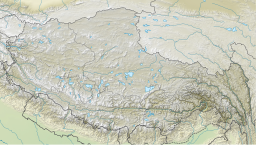
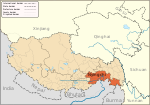
252:, China, approximately 300 km (190 mi) east of
985:
236:), literally meaning “three rocks” in Tibetan, is a
928:
902:
786:
743:
720:
169:
161:
153:
145:
141:
130:
91:
80:
32:
936:Red Building of the Zamu Central County Committee
92:
1005:
698:
676:, due to the similarity of the Chinese names.
656:
652:; The name is sometimes confused with Basum (
8:
1012:
998:
705:
691:
683:
268:
29:
621:
7:
962:
960:
984:. You can help Knowledge (XXG) by
27:Lake in People's Republic of China
25:
240:covering 28 square kilometres in
62:
44:View north-east from Tashi Island
964:
734:
61:
54:
38:
168:
160:
157:27 km (10 sq mi)
152:
144:
657:
232:
223:
215:
1:
272:Climate data for Pagsum Lake
173:3,700 m (12,100 ft)
79:
461:Mean daily minimum °C (°F)
321:Mean daily maximum °C (°F)
1057:
959:
604:
271:
946:Yigong General's Building
732:
530:
460:
390:
320:
315:
312:
309:
306:
303:
300:
297:
294:
291:
288:
285:
282:
279:
276:
187:
49:
37:
1041:Nyingchi geography stubs
633:
165:120 m (390 ft)
634:西藏地名 | བོད་ལྗོངས་ས་མིང།
250:Tibet Autonomous Region
149:18 km (11 mi)
980:location article is a
115:30.01417°N 93.95028°E
242:Gongbo'gyamda County
85:Gongbo'gyamda County
638:Tibetan Place Names
391:Daily mean °C (°F)
220:traditional Chinese
111: /
787:Towns and villages
212:simplified Chinese
120:30.01417; 93.95028
993:
992:
954:
953:
612:
611:
177:
176:
170:Surface elevation
16:(Redirected from
1048:
1014:
1007:
1000:
968:
961:
941:Lieshan Cemetery
738:
707:
700:
693:
684:
677:
667:
660:
659:
651:
626:
607:Climate-Data.org
269:
234:
225:
217:
189:
126:
125:
123:
122:
121:
116:
112:
109:
108:
107:
104:
94:
65:
64:
58:
42:
30:
21:
1056:
1055:
1051:
1050:
1049:
1047:
1046:
1045:
1021:
1020:
1019:
1018:
957:
955:
950:
924:
898:
782:
739:
730:
716:
711:
681:
680:
665:
648:
635:
628:
627:
623:
618:
613:
599:
594:
589:
584:
579:
574:
569:
564:
559:
554:
549:
544:
539:
525:
520:
515:
510:
505:
500:
495:
490:
485:
480:
475:
470:
465:
455:
450:
445:
440:
435:
430:
425:
420:
415:
410:
405:
400:
395:
385:
380:
375:
370:
365:
360:
355:
350:
345:
340:
335:
330:
325:
266:
196:brag gsum mtsho
134: countries
119:
117:
113:
110:
105:
102:
100:
98:
97:
76:
75:
74:
73:
72:
71:
70:
66:
45:
28:
23:
22:
15:
12:
11:
5:
1054:
1052:
1044:
1043:
1038:
1033:
1031:Lakes of Tibet
1023:
1022:
1017:
1016:
1009:
1002:
994:
991:
990:
969:
952:
951:
949:
948:
943:
938:
932:
930:
926:
925:
923:
922:
917:
912:
906:
904:
900:
899:
897:
896:
891:
886:
881:
876:
871:
866:
861:
856:
851:
846:
841:
836:
831:
826:
821:
816:
811:
806:
801:
796:
790:
788:
784:
783:
781:
780:
775:
770:
765:
760:
755:
749:
747:
741:
740:
733:
731:
726:
724:
718:
717:
712:
710:
709:
702:
695:
687:
679:
678:
646:
620:
619:
617:
614:
610:
609:
602:
601:
596:
591:
586:
581:
576:
571:
566:
561:
556:
551:
546:
541:
536:
528:
527:
522:
517:
512:
507:
502:
497:
492:
487:
482:
477:
472:
467:
462:
458:
457:
452:
447:
442:
437:
432:
427:
422:
417:
412:
407:
402:
397:
392:
388:
387:
382:
377:
372:
367:
362:
357:
352:
347:
342:
337:
332:
327:
322:
318:
317:
314:
311:
308:
305:
302:
299:
296:
293:
290:
287:
284:
281:
278:
274:
273:
267:
265:
262:
175:
174:
171:
167:
166:
163:
159:
158:
155:
151:
150:
147:
143:
142:
139:
138:
135:
128:
127:
95:
89:
88:
82:
78:
77:
68:
67:
60:
59:
53:
52:
51:
50:
47:
46:
43:
35:
34:
26:
24:
14:
13:
10:
9:
6:
4:
3:
2:
1053:
1042:
1039:
1037:
1034:
1032:
1029:
1028:
1026:
1015:
1010:
1008:
1003:
1001:
996:
995:
989:
987:
983:
979:
975:
970:
967:
963:
958:
947:
944:
942:
939:
937:
934:
933:
931:
927:
921:
918:
916:
913:
911:
908:
907:
905:
901:
895:
892:
890:
887:
885:
882:
880:
877:
875:
872:
870:
867:
865:
862:
860:
857:
855:
852:
850:
847:
845:
842:
840:
837:
835:
832:
830:
827:
825:
822:
820:
817:
815:
812:
810:
807:
805:
802:
800:
797:
795:
792:
791:
789:
785:
779:
776:
774:
771:
769:
766:
764:
761:
759:
758:Gongbo'gyamda
756:
754:
751:
750:
748:
746:
742:
737:
729:
725:
723:
719:
715:
708:
703:
701:
696:
694:
689:
688:
685:
675:
671:
670:Tingri County
664:
655:
649:
647:7-80057-284-6
643:
639:
632:
625:
622:
615:
608:
603:
597:
592:
587:
582:
577:
572:
567:
562:
557:
552:
547:
542:
537:
534:
533:precipitation
529:
523:
518:
513:
508:
503:
498:
493:
488:
483:
478:
473:
468:
463:
459:
453:
448:
443:
438:
433:
428:
423:
418:
413:
408:
403:
398:
393:
389:
383:
378:
373:
368:
363:
358:
353:
348:
343:
338:
333:
328:
323:
319:
275:
270:
263:
261:
259:
255:
251:
247:
243:
239:
235:
229:
221:
213:
209:
205:
201:
197:
193:
188:བྲག་གསུམ་མཚོ་
185:
181:
172:
164:
156:
148:
140:
136:
133:
129:
124:
96:
90:
86:
83:
57:
48:
41:
36:
31:
19:
986:expanding it
971:
956:
919:
662:
654:Basong Xiang
653:
637:
630:
624:
535:mm (inches)
257:
231:
207:
203:
195:
180:Dragsum Tsho
179:
178:
154:Surface area
920:Pagsum Lake
915:Nyang River
258:Gongga Lake
204:Draksum Tso
146:Max. length
118: /
93:Coordinates
1025:Categories
889:Xia Lingka
233:Bāsōng Cuò
162:Max. depth
106:93°57′01″E
103:30°00′51″N
903:Geography
824:Chubalung
819:Chubarong
809:Tsawarong
663:dba’ gsum
616:Footnotes
208:Pagsum Co
69:Pagsum Co
33:Pagsum Co
18:Pagsum Co
1036:Nyingchi
974:Nyingchi
910:Ba River
834:Gohaling
763:Mainling
745:Counties
722:District
714:Nyingchi
674:Shigatse
666:དབའ་གསུམ
605:Source:
531:Average
246:Nyingchi
81:Location
929:Culture
874:Qizhong
849:Dombang
600:(21.4)
526:(32.4)
521:(16.2)
516:(23.2)
511:(34.5)
506:(43.9)
501:(47.3)
496:(48.4)
491:(45.9)
486:(38.8)
481:(31.6)
476:(25.3)
471:(19.2)
466:(14.0)
456:(44.4)
451:(30.0)
446:(36.7)
441:(46.4)
436:(54.5)
431:(57.9)
426:(58.6)
421:(56.7)
416:(50.7)
411:(44.2)
406:(37.9)
401:(31.8)
396:(27.7)
386:(56.5)
381:(43.9)
376:(50.2)
371:(58.5)
366:(65.1)
361:(68.5)
356:(68.9)
351:(67.5)
346:(62.6)
341:(56.8)
336:(50.5)
331:(44.4)
326:(41.4)
264:Climate
248:of the
184:Tibetan
87:, Tibet
894:Tramog
879:Qoidên
869:Puzang
829:Gartog
794:Alamdo
644:
595:(0.1)
590:(0.2)
585:(1.1)
580:(3.5)
575:(3.9)
570:(4.6)
565:(4.3)
560:(2.0)
555:(1.1)
550:(0.4)
545:(0.1)
540:(0.1)
277:Month
230::
228:pinyin
222::
214::
978:Tibet
972:This
859:Oibab
854:Kamsa
844:Goyul
839:Gunwa
814:Chuka
804:Bamda
773:Zayul
768:Mêdog
668:) in
636:[
464:−10.0
316:Year
254:Lhasa
192:Wylie
137:China
132:Basin
982:stub
884:Rawu
864:Puqu
799:Bayi
778:Nang
753:Pome
728:Bayi
642:ISBN
519:−8.8
514:−4.9
479:−0.2
474:−3.7
469:−7.1
449:−1.1
434:12.5
429:14.4
424:14.8
419:13.7
414:10.4
399:−0.1
394:−2.4
384:13.6
374:10.1
369:14.7
364:18.4
359:20.3
354:20.5
349:19.7
344:17.0
339:13.8
334:10.3
313:Dec
310:Nov
307:Oct
304:Sep
301:Aug
298:Jul
295:Jun
292:May
289:Apr
286:Mar
283:Feb
280:Jan
238:lake
658:巴松乡
598:542
573:100
568:117
563:108
524:0.2
509:1.4
504:6.6
499:8.5
494:9.1
489:7.7
484:3.8
454:6.9
444:2.6
439:8.0
409:6.8
404:3.3
379:6.6
329:6.9
324:5.2
224:八松錯
216:八松错
200:THL
1027::
976:,
672:,
661:/
583:28
578:89
558:51
553:27
548:10
260:.
244:,
226:;
218:;
206:,
202::
198:,
194::
190:,
186::
1013:e
1006:t
999:v
988:.
706:e
699:t
692:v
650:.
593:2
588:5
543:3
538:2
210:(
182:(
20:)
Text is available under the Creative Commons Attribution-ShareAlike License. Additional terms may apply.