131:
45:
138:
335:
130:
524:
519:
187:
416:
archipelago. The Pay-Khoy and Novaya Zemlya are younger than the orogeny that formed the Ural mountains. They were formed during the
389:
87:
438:
372:
180:
80:
457:
44:
529:
323:
173:
488:
The Timan-Pechora Basin
Province of Northwest Arctic Russia: Domanik – Paleozoic Total Petroleum System
367:
250:
486:
433:
Volume 1. Research
Expeditions of the Imperial Russian Geographic Society in 1847, 1848 and 1850.
384:
The areas around Pay-Khoy do not have permanent population. The closest permanent settlements are
343:
260:
434:
417:
243:
63:
359:
168:
409:
405:
363:
347:
319:
219:
513:
413:
292:
351:
277:
378:
346:, in the eastern part of the Nenets Autonomous Okrug. The ridge continues to
202:
189:
102:
89:
469:
334:
273:
265:
355:
342:
The ridge is extended from northwest to southeast. It is located on the
17:
385:
300:
238:
393:
70:
49:
Folded layers of rock of the Pay-Khoy Range at the
Silovayaha River
333:
280:
226:
269:
404:
The Pay-Khoy range forms a curved orogen together with the
458:
362:(467 metres (1,532 ft)). The range separates the
358:. The highest point of Pay-Khoy is the mountain of
291:
286:
259:
249:
237:
232:
218:
179:
167:
159:
118:
79:
69:
59:
54:
32:
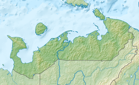
318:) is a mountain range at the northern end of the
431:Northern Urals and the Coastal Range Pai-Khoi.
420:between the Late Triassic and Early Jurassic.
313:
8:
29:
450:
137:
494:. U. S. Geological Survey. p. 11
7:
525:Landforms of Nenets Autonomous Okrug
150:Location in Nenets Autonomous Okrug
25:
396:, to the north of the tree line.
390:Ust-Kara, Nenets Autonomous Okrug
136:
129:
43:
255:Late Triassic - Early Jurassic.
485:Lindquist, Sandra J. (1999).
1:
474:. Great Soviet Encyclopedia.
392:The range is located in the
377:(west, Barents Sea) and the
546:
75:423 m (1,388 ft)
520:Mountain ranges of Russia
314:
123:
42:
37:
27:Mountain range in Russia
324:Nenets Autonomous Okrug
203:69.203553°N 62.607785°E
174:Nenets Autonomous Okrug
350:, thus separating the
339:
337:
322:. It lies within the
103:69.42750°N 62.20889°E
208:69.203553; 62.607785
199: /
99: /
381:(east, Kara Sea).
344:Yugorsky Peninsula
340:
108:69.42750; 62.20889
55:Highest point
418:Cimmerian Orogeny
306:
305:
244:Cimmerian Orogeny
181:Range coordinates
16:(Redirected from
537:
504:
503:
501:
499:
493:
482:
476:
475:
466:
460:
455:
429:Kovalskiy, M.A.
376:
368:Korotaikha River
317:
316:
295:
222:
214:
213:
211:
210:
209:
204:
200:
197:
196:
195:
192:
140:
139:
133:
114:
113:
111:
110:
109:
104:
100:
97:
96:
95:
92:
47:
30:
21:
545:
544:
540:
539:
538:
536:
535:
534:
510:
509:
508:
507:
497:
495:
491:
484:
483:
479:
468:
467:
463:
456:
452:
447:
426:
402:
370:
364:drainage basins
332:
293:
220:
207:
205:
201:
198:
193:
190:
188:
186:
185:
169:Federal subject
155:
154:
153:
152:
151:
148:
147:
146:
145:
141:
107:
105:
101:
98:
93:
90:
88:
86:
85:
50:
28:
23:
22:
15:
12:
11:
5:
543:
541:
533:
532:
530:Ural Mountains
527:
522:
512:
511:
506:
505:
477:
461:
449:
448:
446:
443:
442:
441:
425:
422:
410:Vaygach Island
406:Ural Mountains
401:
398:
348:Vaygach Island
338:Pay-Khoy Range
331:
328:
320:Ural Mountains
315:хребет Пай-Хой
312:(Russian:
310:Pay-Khoy Range
304:
303:
297:
289:
288:
284:
283:
263:
257:
256:
253:
247:
246:
241:
235:
234:
230:
229:
224:
216:
215:
183:
177:
176:
171:
165:
164:
161:
157:
156:
149:
144:Pay-Khoy Range
143:
142:
135:
134:
128:
127:
126:
125:
124:
121:
120:
116:
115:
83:
77:
76:
73:
67:
66:
61:
57:
56:
52:
51:
48:
40:
39:
38:хребет Пай-Хой
35:
34:
33:Pay-Khoy Range
26:
24:
14:
13:
10:
9:
6:
4:
3:
2:
542:
531:
528:
526:
523:
521:
518:
517:
515:
490:
489:
481:
478:
473:
472:
465:
462:
459:
454:
451:
444:
440:
436:
432:
428:
427:
423:
421:
419:
415:
414:Novaya Zemlya
411:
407:
399:
397:
395:
391:
387:
382:
380:
374:
369:
365:
361:
357:
353:
349:
345:
336:
329:
327:
325:
321:
311:
302:
298:
296:
294:Easiest route
290:
285:
282:
279:
275:
271:
267:
264:
262:
258:
254:
252:
248:
245:
242:
240:
236:
231:
228:
225:
223:
217:
212:
184:
182:
178:
175:
172:
170:
166:
162:
158:
132:
122:
117:
112:
84:
82:
78:
74:
72:
68:
65:
62:
58:
53:
46:
41:
36:
31:
19:
496:. Retrieved
487:
480:
470:
464:
453:
430:
424:Bibliography
403:
383:
341:
309:
307:
261:Type of rock
221:Parent range
498:28 December
371: [
352:Barents Sea
278:crystalline
251:Age of rock
206: /
106: /
81:Coordinates
514:Categories
445:References
439:5519416656
379:Kara River
194:62°36′28″E
191:69°12′13″N
94:62°12′32″E
91:69°25′39″N
330:Geography
274:limestone
266:Sandstone
119:Geography
71:Elevation
412:and the
356:Kara Sea
354:and the
287:Climbing
64:Morye-Iz
18:Pai-Khoi
471:Пай-Хой
400:Geology
386:Amderma
366:of the
301:Amderma
239:Orogeny
233:Geology
160:Country
437:
394:tundra
360:Moreiz
163:Russia
492:(PDF)
375:]
299:From
281:shale
227:Urals
500:2021
435:ISBN
388:and
308:The
276:and
270:marl
60:Peak
516::
408:,
373:ru
326:.
272:,
268:,
502:.
20:)
Text is available under the Creative Commons Attribution-ShareAlike License. Additional terms may apply.