328:
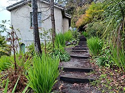
are also placed around the hill indicating the direction of the closest set of 'steps off the hill' for visitors who become lost among the trees, architecture, and windy roads. The lower steps are called
Orchard Lane, and split at Panoramic Way (the vehicle road) and Mosswood Path a pedestrian pathway covered by antique red woods. Arden Steps are the penultimate set of steps in the series and are severely steep. Arden Steps and Arden Path meet at the cul-de-sac of Arden Road where Arden Path finishes the series with a sloping path and a final series up two dozen wooden steps.
445:"The quality of this area depends not so much on its individual buildings, though there are many fine structures by Berkeley's most important designers, but upon the survival of a complete neighborhood that provides a background for these buildings. Thus, the individual designs of Coxhead, Morgan, or Maybeck do not appear as museum pieces in a glass case, divorced of context, but convey the image and atmosphere of the intellectual and cultural milieu which aspired at the turn of the century to be the Athens of the West."
60:
320:
367:
44:
1136:
437:
355:
312:
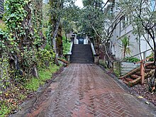
335:"One of Berkeley's romantic treasures, Orchard Lane is the formal pedestrian entrance to the Panoramic Hill residential neighborhood. The walk and Classical staircase, complete with pillars, balustrades, concrete benches, and an overhanging bower of trees, was built by Warren Cheney, who developed Panoramic Hill. In 1904 Cheney, the former editor of the literary magazine
1146:
67:
327:
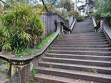
Panoramic Hill is home to a series of maintained walking paths and staircases that lead, on and off the road, halfway up the hill where they intersect a series of fire trails that lead into the hills. Each set of steps is treated as its own walking byway and is therefore named and well marked. Signs
293:
Panoramic Way is a very steep and narrow public road with numerous sharp turns and curves serving approximately 500 residents. Traffic can become difficult during rush hours, waste collection times or when construction and service vehicles are present. Emergency vehicles do regular patrols of the
302:
Because of the
Panoramic Hill Neighborhood's situation between both the city of Berkeley and the city of Oakland it is regulated by both cities with parking regulation. The Berkeley portion of the hill has a 2-hour limit and is patrolled between 8 AM and 7 PM, Monday through Saturday, excluding
1556:
303:
holidays. Residents can acquire a "K" parking permit. Parking in the
Oakland portion of the hill is also limited to 2 hours and is patrolled between 8 AM and 6 PM, Monday through Friday. Residents can acquire an "L" parking permit.
294:
area to test their ability to access all residents in case of emergency. Where the street is only wide enough for one car, the car facing downhill must yield to the car facing uphill, as required by
California Motor Vehicle Code.
1551:
1561:
285:. It includes the streets of Panoramic Way, Mosswood Road, Panoramic Place (Berkeley), Panoramic Place (Oakland), Arden Road, Dwight Place, and Dwight Way. The neighborhood is approximately 0.258 square miles.
1182:
1078:
416:
The upper and lower Jordan trails are fire trails through the
University of California ecological area. The university is required to keep the trails open for emergency vehicle access.
339:
purchased the land. In 1909 he commissioned Henry Atkins to design the stairway that still links residences with the
University and town and other walkways that climb the hill."
91:
564:"Panoramic Hill neighborhood in Berkeley, California (CA), 94704 subdivision profile - real estate, apartments, condos, homes, community, population, jobs, income, streets"
1251:
499:
built homes each uniquely adapting to the geography and encapsulating the view. The
Panoramic Hill neighborhood is frequently a part of architectural walking tours in
1175:
1536:
760:
1546:
1541:
785:
1500:
1191:
504:
1168:
709:
1241:
1073:
1465:
920:
810:
800:
795:
405:
200:
1231:
1515:
1387:
59:
1490:
1425:
1289:
855:
835:
830:
544:
401:
191:
159:
1505:
870:
865:
659:
1455:
1445:
1440:
1359:
1349:
947:
753:
266:
262:
1475:
1412:
1367:
1329:
1281:
1261:
1226:
903:
1372:
1339:
1309:
1271:
1211:
898:
1435:
1382:
1314:
1236:
1099:
860:
845:
840:
577:
1495:
1392:
1334:
1324:
1304:
1149:
875:
805:
777:
147:
1470:
1402:
1397:
1344:
1299:
1294:
1139:
1109:
1057:
815:
746:
1510:
1430:
1009:
397:
Established in 1904 by Warren Cheney, the
Panoramic Hill neighborhood of Berkeley and Oakland enjoys a robust history.
1319:
974:
969:
516:
425:
1420:
1094:
989:
979:
942:
274:
152:
1116:
1040:
984:
43:
700:
1104:
488:
1121:
1045:
1030:
261:
The
Panoramic Hill Neighborhood is located at the eastern edge of the city of Berkeley, southeast of the
937:
908:
563:
549:
476:
281:
and the main
University of California campus. The eastern half of this neighborhood is in the City of
1035:
769:
689:
599:
500:
270:
246:
168:
1480:
1221:
915:
684:
645:
282:
250:
164:
1246:
1216:
667:
496:
480:
464:
17:
319:
278:
123:
1199:
1004:
331:
A plaque at the entrance to the Orchard Lane and thus the bottom of the hill is inscribed:
994:
790:
492:
472:
468:
428:
frequently conducts walking tours of Panoramic Hill and its surrounding trails and views.
1266:
1160:
820:
460:
366:
218:
1530:
999:
128:
631:
253:
defined by the homes along and within the access corridor defined by Panoramic Way.
1203:
1052:
825:
585:
456:
242:
1256:
436:
354:
311:
1025:
140:
135:
724:
711:
106:
93:
1557:
Historic districts on the National Register of Historic Places in California
1377:
484:
503:. Panoramic Hill was named "Berkeley's Most Romantic Neighborhood" by the
738:
323:
Signs Frequent The Hill To Indicate How to Get Down and "Off The Hill."
613:
435:
353:
318:
310:
539:
1164:
742:
694:
361:
1552:
National Register of Historic Places in Berkeley, California
697:, a fee supported representative group for the neighborhood.
1562:
National Register of Historic Places in Oakland, California
578:"California Driver Handbook - Laws and Rules of the Road"
378:
265:
campus, and situated at the northwestern foot of the
646:"BAHA :: Panoramic Hill House Tour Photo Album"
1454:
1411:
1358:
1280:
1198:
1087:
1066:
1018:
960:
930:
891:
884:
776:
224:
211:
158:
146:
134:
122:
34:
443:
333:
1176:
754:
8:
455:Panoramic Hill features the architecture of
703:, a community supported neighborhood forum.
505:Berkeley Architectural Heritage Association
1183:
1169:
1161:
888:
761:
747:
739:
660:"Berkeley Panoramic Hill - Red Oak Realty"
31:
192:U.S. National Register of Historic Places
632:"BAHA :: 41 Berkeley Walking Tours"
528:
344:Berkeley Historical Plaque Project 1998
121:
86:
52:
40:
540:"National Register Information System"
534:
532:
66:
1537:Neighborhoods in Berkeley, California
600:"BAHA :: 2005 Spring House Tour"
157:
145:
133:
7:
1547:Populated places established in 1904
1542:Neighborhoods in Oakland, California
1192:Neighborhoods in Oakland, California
1145:
545:National Register of Historic Places
402:National Register of Historic Places
79:Location within Oakland and Berkeley
1079:List of Berkeley High School people
990:San Pablo Avenue (State Route 123)
948:University of California, Berkeley
267:Claremont Canyon Regional Preserve
29:Place in California, United States
25:
273:. The neighborhood is bounded by
1144:
1135:
1134:
899:Berkeley Unified School District
400:Panoramic Hill was added to the
365:
65:
58:
42:
18:Panoramic Hill Historic District
921:California School for the Deaf
695:The Panoramic Hill Association
213:
1:
985:Ashby Avenue (State Route 13)
892:Primary and secondary schools
701:The Panoramic Hill Advocates
495:as well as a wide variety of
358:A staircase in Panoramic Hill
1252:Lakeside Apartments District
1074:List of people from Berkeley
786:Berkeley High School Campus
690:Panoramic Hill House Tour 2
685:Panoramic Hill House Tour 1
517:California Memorial Stadium
426:Berkeley Historical Society
1578:
1110:1969 People's Park protest
943:Graduate Theological Union
923:(moved to Fremont in 1980)
1130:
931:Colleges and universities
232:
212:NRHP reference
207:
198:
189:
182:
178:
174:
87:
53:
48:A house in Panoramic Hill
41:
263:University of California
1058:Berkeley Amtrak station
725:37.86948°N 122.248845°W
489:Harwell Hamilton Harris
107:37.86948°N 122.248845°W
1501:Mountain View Cemetery
453:
441:
359:
347:
324:
316:
307:Panoramic Walking Path
201:U.S. Historic district
1019:Public transportation
938:Berkeley City College
909:Berkeley Adult School
730:37.86948; -122.248845
550:National Park Service
439:
357:
322:
314:
112:37.86948; -122.248845
1242:Jack London District
904:Berkeley High School
770:Berkeley, California
664:www.redoakrealty.com
618:berkeleyheritage.com
1481:Joaquin Miller Park
916:Maybeck High School
721: /
670:on August 31, 2007.
588:on August 20, 2008.
251:Oakland, California
103: /
1247:Jack London Square
481:Frank Lloyd Wright
465:John Hudson Thomas
442:
420:Points of interest
377:. You can help by
360:
325:
317:
1524:
1523:
1272:Cleveland Heights
1232:Crocker Highlands
1158:
1157:
1095:List of landmarks
1041:Downtown Berkeley
1010:University Avenue
956:
955:
811:Downtown Berkeley
406:historic district
395:
394:
279:Clark Kerr Campus
245:of the cities of
241:is a residential
236:
235:
16:(Redirected from
1569:
1516:Sequoyah Heights
1185:
1178:
1171:
1162:
1148:
1147:
1138:
1137:
1005:Telegraph Avenue
889:
763:
756:
749:
740:
736:
735:
733:
732:
731:
726:
722:
719:
718:
717:
714:
672:
671:
666:. Archived from
656:
650:
649:
642:
636:
635:
628:
622:
621:
610:
604:
603:
596:
590:
589:
584:. Archived from
574:
568:
567:
560:
554:
553:
536:
477:Walter Steilberg
451:
390:
387:
369:
362:
345:
337:The Californian,
228:October 21, 2005
215:
118:
117:
115:
114:
113:
108:
104:
101:
100:
99:
96:
69:
68:
62:
46:
32:
21:
1577:
1576:
1572:
1571:
1570:
1568:
1567:
1566:
1527:
1526:
1525:
1520:
1491:Redwood Heights
1457:
1450:
1426:Cypress Village
1407:
1388:Piedmont Avenue
1354:
1290:Dimond District
1276:
1194:
1189:
1159:
1154:
1126:
1083:
1062:
1014:
995:Shattuck Avenue
980:Piedmont Avenue
962:
952:
926:
880:
791:Berkeley Marina
772:
767:
729:
727:
723:
720:
715:
712:
710:
708:
707:
681:
676:
675:
658:
657:
653:
644:
643:
639:
630:
629:
625:
612:
611:
607:
598:
597:
593:
576:
575:
571:
562:
561:
557:
552:. July 9, 2010.
538:
537:
530:
525:
513:
493:Bernard Maybeck
473:William Wurster
469:Walter Ratcliff
452:
449:
434:
422:
414:
391:
385:
382:
375:needs expansion
352:
346:
343:
309:
300:
291:
275:Piedmont Avenue
271:Claremont Hills
259:
203:
194:
185:
111:
109:
105:
102:
97:
94:
92:
90:
89:
83:
82:
81:
80:
77:
76:
75:
74:
70:
49:
37:
30:
23:
22:
15:
12:
11:
5:
1575:
1573:
1565:
1564:
1559:
1554:
1549:
1544:
1539:
1529:
1528:
1522:
1521:
1519:
1518:
1513:
1508:
1506:Piedmont Pines
1503:
1498:
1493:
1488:
1486:Panoramic Hill
1483:
1478:
1473:
1468:
1462:
1460:
1452:
1451:
1449:
1448:
1443:
1438:
1433:
1428:
1423:
1417:
1415:
1409:
1408:
1406:
1405:
1400:
1395:
1390:
1385:
1380:
1375:
1370:
1364:
1362:
1356:
1355:
1353:
1352:
1347:
1342:
1337:
1332:
1327:
1322:
1317:
1312:
1307:
1302:
1297:
1292:
1286:
1284:
1278:
1277:
1275:
1274:
1269:
1264:
1259:
1254:
1249:
1244:
1239:
1234:
1229:
1224:
1219:
1214:
1208:
1206:
1196:
1195:
1190:
1188:
1187:
1180:
1173:
1165:
1156:
1155:
1153:
1152:
1142:
1131:
1128:
1127:
1125:
1124:
1119:
1114:
1113:
1112:
1105:1960s protests
1102:
1097:
1091:
1089:
1085:
1084:
1082:
1081:
1076:
1070:
1068:
1064:
1063:
1061:
1060:
1055:
1050:
1049:
1048:
1046:North Berkeley
1043:
1038:
1028:
1022:
1020:
1016:
1015:
1013:
1012:
1007:
1002:
997:
992:
987:
982:
977:
975:Interstate 580
972:
966:
964:
958:
957:
954:
953:
951:
950:
945:
940:
934:
932:
928:
927:
925:
924:
918:
913:
912:
911:
906:
895:
893:
886:
882:
881:
879:
878:
873:
868:
863:
858:
856:South Berkeley
853:
851:Panoramic Hill
848:
843:
838:
836:North Berkeley
833:
831:Lorin District
828:
823:
821:Gourmet Ghetto
818:
813:
808:
803:
798:
793:
788:
782:
780:
774:
773:
768:
766:
765:
758:
751:
743:
705:
704:
698:
692:
687:
680:
679:External links
677:
674:
673:
651:
637:
623:
605:
591:
582:www.dmv.ca.gov
569:
555:
527:
526:
524:
521:
520:
519:
512:
509:
461:Ernest Coxhead
447:
440:Panoramic Hill
433:
430:
421:
418:
413:
410:
393:
392:
372:
370:
351:
348:
341:
308:
305:
299:
296:
290:
287:
258:
255:
239:Panoramic Hill
234:
233:
230:
229:
226:
222:
221:
216:
209:
208:
205:
204:
199:
196:
195:
190:
187:
186:
184:Panoramic Hill
183:
180:
179:
176:
175:
172:
171:
162:
156:
155:
150:
144:
143:
138:
132:
131:
126:
120:
119:
85:
84:
78:
73:Panoramic Hill
72:
71:
64:
63:
57:
56:
55:
54:
51:
50:
47:
39:
38:
36:Panoramic Hill
35:
28:
24:
14:
13:
10:
9:
6:
4:
3:
2:
1574:
1563:
1560:
1558:
1555:
1553:
1550:
1548:
1545:
1543:
1540:
1538:
1535:
1534:
1532:
1517:
1514:
1512:
1509:
1507:
1504:
1502:
1499:
1497:
1494:
1492:
1489:
1487:
1484:
1482:
1479:
1477:
1474:
1472:
1469:
1467:
1464:
1463:
1461:
1459:
1458:and foothills
1456:Oakland Hills
1453:
1447:
1446:Oakland Point
1444:
1442:
1441:Lower Bottoms
1439:
1437:
1434:
1432:
1429:
1427:
1424:
1422:
1419:
1418:
1416:
1414:
1410:
1404:
1401:
1399:
1396:
1394:
1391:
1389:
1386:
1384:
1381:
1379:
1376:
1374:
1371:
1369:
1366:
1365:
1363:
1361:
1360:North Oakland
1357:
1351:
1350:Sobrante Park
1348:
1346:
1343:
1341:
1338:
1336:
1333:
1331:
1328:
1326:
1323:
1321:
1318:
1316:
1313:
1311:
1308:
1306:
1303:
1301:
1298:
1296:
1293:
1291:
1288:
1287:
1285:
1283:
1279:
1273:
1270:
1268:
1265:
1263:
1260:
1258:
1255:
1253:
1250:
1248:
1245:
1243:
1240:
1238:
1235:
1233:
1230:
1228:
1225:
1223:
1220:
1218:
1215:
1213:
1210:
1209:
1207:
1205:
1201:
1197:
1193:
1186:
1181:
1179:
1174:
1172:
1167:
1166:
1163:
1151:
1143:
1141:
1133:
1132:
1129:
1123:
1122:2017 protests
1120:
1118:
1115:
1111:
1108:
1107:
1106:
1103:
1101:
1098:
1096:
1093:
1092:
1090:
1086:
1080:
1077:
1075:
1072:
1071:
1069:
1065:
1059:
1056:
1054:
1051:
1047:
1044:
1042:
1039:
1037:
1034:
1033:
1032:
1029:
1027:
1024:
1023:
1021:
1017:
1011:
1008:
1006:
1003:
1001:
1000:Solano Avenue
998:
996:
993:
991:
988:
986:
983:
981:
978:
976:
973:
971:
970:Interstate 80
968:
967:
965:
959:
949:
946:
944:
941:
939:
936:
935:
933:
929:
922:
919:
917:
914:
910:
907:
905:
902:
901:
900:
897:
896:
894:
890:
887:
883:
877:
874:
872:
871:West Berkeley
869:
867:
866:Thousand Oaks
864:
862:
859:
857:
854:
852:
849:
847:
844:
842:
839:
837:
834:
832:
829:
827:
824:
822:
819:
817:
814:
812:
809:
807:
804:
802:
799:
797:
794:
792:
789:
787:
784:
783:
781:
779:
778:Neighborhoods
775:
771:
764:
759:
757:
752:
750:
745:
744:
741:
737:
734:
702:
699:
696:
693:
691:
688:
686:
683:
682:
678:
669:
665:
661:
655:
652:
647:
641:
638:
633:
627:
624:
619:
615:
609:
606:
601:
595:
592:
587:
583:
579:
573:
570:
565:
559:
556:
551:
547:
546:
541:
535:
533:
529:
522:
518:
515:
514:
510:
508:
506:
502:
498:
494:
490:
486:
482:
478:
474:
470:
466:
462:
458:
446:
438:
431:
429:
427:
419:
417:
411:
409:
407:
403:
398:
389:
380:
376:
373:This section
371:
368:
364:
363:
356:
349:
340:
338:
332:
329:
321:
313:
306:
304:
297:
295:
288:
286:
284:
280:
276:
272:
268:
264:
256:
254:
252:
248:
244:
240:
231:
227:
225:Added to NRHP
223:
220:
217:
210:
206:
202:
197:
193:
188:
181:
177:
173:
170:
166:
163:
161:
154:
151:
149:
142:
139:
137:
130:
129:United States
127:
125:
116:
88:Coordinates:
61:
45:
33:
27:
19:
1485:
1476:Grass Valley
1413:West Oakland
1368:Bushrod Park
1330:Maxwell Park
1282:East Oakland
1262:Trestle Glen
1227:Civic Center
1204:Lake Merritt
1053:Bear Transit
963:and highways
850:
826:La Loma Park
796:Civic Center
706:
668:the original
663:
654:
640:
626:
617:
608:
594:
586:the original
581:
572:
558:
543:
457:Julia Morgan
454:
444:
432:Architecture
423:
415:
399:
396:
383:
379:adding to it
374:
336:
334:
330:
326:
315:Orchard Lane
301:
292:
260:
243:neighborhood
238:
237:
26:
1373:Golden Gate
1340:San Antonio
1310:Havenscourt
1257:Old Oakland
1222:City Center
1212:Adams Point
961:Trunk roads
728: /
716:122°14′56″W
110: /
98:122°14′56″W
1531:Categories
1436:Ghost Town
1383:Longfellow
1315:Jingletown
1237:Grand Lake
1026:AC Transit
713:37°52′10″N
523:References
450:John Beach
412:Fire Trail
141:California
95:37°52′10″N
1496:Montclair
1466:Claremont
1393:Rockridge
1378:Koreatown
1335:Ridgemont
1325:Millsmont
1305:Fruitvale
1217:Chinatown
1117:1991 fire
1100:1923 fire
885:Education
861:Southside
846:Northside
841:Northbrae
801:Claremont
497:craftsman
485:Mark Mack
408:in 2005.
386:July 2013
257:Geography
1471:Glenview
1403:Temescal
1398:Santa Fe
1345:Seminary
1300:Elmhurst
1295:Eastmont
1200:Downtown
1140:Category
876:Westbrae
806:Cragmont
511:See also
501:Berkeley
448:—
342:—
269:and the
247:Berkeley
219:05000424
169:Berkeley
1511:Oakmore
1431:Dogtown
1150:Commons
1088:History
816:Elmwood
350:History
298:Parking
289:Traffic
283:Oakland
165:Oakland
153:Alameda
124:Country
1320:Laurel
1267:Uptown
1067:People
614:"Home"
277:, the
160:Cities
148:County
1421:Acorn
1036:Ashby
404:as a
136:State
1031:BART
491:and
424:The
249:and
167:and
381:.
214:No.
1533::
1202:/
662:.
616:.
580:.
548:.
542:.
531:^
507:.
487:,
483:,
479:,
475:,
471:,
467:,
463:,
459:,
1184:e
1177:t
1170:v
762:e
755:t
748:v
648:.
634:.
620:.
602:.
566:.
388:)
384:(
20:)
Text is available under the Creative Commons Attribution-ShareAlike License. Additional terms may apply.