134:
127:
29:
250:
ten-member Indian team of (Mountaineers
Association of Krishnanagar, Nadia, West Bengal) made a successful ascent of Panwali Dwar the team led by Debasis Biswas. Basant Singha Roy, Debasis Biswas, Pasang Sherpa and Pemba Sherpa reached the summit. They had followed the traditional route of the first ascent.
249:
It was first observed by W. Noyce in 1944 but no attempts were made until 1979 when a
Japanese team failed on the first assault. They returned in 1980 and successfully climbed it. In 1990 A team from Bombay led by Prajapati Bodane also claimed of climbing Panwali Dwar. On 22 August 2006. a
225:, India. The elevation of Panwali Dwar is 6,683 metres (21,926 ft) and its prominence is 763 metres (2,503 ft). It is 55th highest located entirely within the Uttarakhand.
788:
793:
126:
681:
69:
783:
83:
752:
229:, is the highest mountain in this category. It lies on southern wall of Nanda devi sanctuary. Its nearest higher neighbor
76:
612:
258:
567:
531:
495:
459:
423:
387:
351:
315:
277:
one of the main sources of river Ganga. which later joins
Bhagirathi river the other main tributaries of river
54:
697:
159:
64:
677:
28:
671:
286:
270:
238:
211:
181:
174:
777:
290:
274:
233:
6,803 metres (22,320 ft) lies 8.2 km WSW. It is located 2.6 km SW of
266:
196:
294:
262:
222:
163:
727:
642:
525:
381:
309:
282:
234:
226:
582:
569:
546:
533:
510:
497:
474:
461:
438:
425:
402:
389:
366:
353:
330:
317:
98:
85:
620:
489:
218:
214:
184:
561:
230:
453:
417:
345:
44:
278:
167:
33:
Panwali Dwar and Nanda Khat from
Chiltha Mai near Dhakuri top
698:"EXPEDITIONS AND NOTES : Himalayan Journal vol.48/21"
261:
lies on the northern side of
Panwali Dwar. It drains into
237:
6,611 metres (21,690 ft) and 9.2 km NE lies
285:
and became Ganga there after. On the east side lies
195:
190:
173:
155:
114:
75:
63:
53:
43:
38:
21:
665:
663:
8:
673:Across Peaks & Passes in Kumaun Himalaya
305:The neighboring peaks of Panwali Dwar are:
18:
604:
7:
297:and became part of Alaknanda river.
293:which also joins Alaknanda river at
269:at Rini and Dhauli Ganga merge with
133:
753:"Devprayag | Times of India Travel"
728:"Indian Mountaineering Foundation"
676:. Indus Publishing. pp. 35–.
201:A Japanese team climbed it in 1980
14:
789:Six-thousanders of the Himalayas
132:
125:
27:
564:: 6,322 m (20,741 ft)
528:: 6,611 m (21,690 ft)
492:: 6,861 m (22,510 ft)
456:: 6,099 m (20,010 ft)
420:: 6,788 m (22,270 ft)
384:: 6,678 m (21,909 ft)
348:: 7,120 m (23,360 ft)
312:: 7,816 m (25,643 ft)
241:7,434 metres (24,390 ft).
16:Mountain in Uttarakhand, India
1:
794:Geography of Chamoli district
49:6,663 m (21,860 ft)
757:timesofindia.indiatimes.com
259:Dakshini Nanda Devi Glacier
810:
59:763 m (2,503 ft)
119:
26:
784:Mountains of Uttarakhand
70:Mountains of Uttarakhand
670:Harish Kapadia (1999).
146:Location in Uttarakhand
702:www.himalayanclub.org
583:30.29278°N 79.03944°E
547:30.30111°N 79.97667°E
511:30.28000°N 79.07000°E
475:30.22500°N 79.82333°E
439:30.28583°N 79.85333°E
403:30.34000°N 79.88000°E
367:30.31000°N 79.77000°E
331:30.92000°N 79.59167°E
210:is a mountain of the
99:30.28944°N 79.95583°E
579: /
543: /
507: /
471: /
435: /
399: /
363: /
327: /
289:from their emerges
254:Glaciers and rivers
95: /
588:30.29278; 79.03944
552:30.30111; 79.97667
516:30.28000; 79.07000
480:30.22500; 79.82333
444:30.28583; 79.85333
408:30.34000; 79.88000
372:30.31000; 79.77000
336:30.92000; 79.59167
265:which later joins
160:Bageshwar district
104:30.28944; 79.95583
39:Highest point
683:978-81-7387-096-5
301:Neighboring peaks
205:
204:
801:
768:
767:
765:
763:
749:
743:
742:
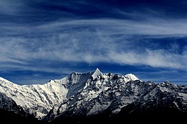
740:
738:
732:www.indmount.org
724:
718:
717:
715:
713:
694:
688:
687:
667:
658:
657:
655:
653:
639:
633:
632:
630:
628:
619:. Archived from
609:
594:
593:
591:
590:
589:
584:
580:
577:
576:
575:
572:
558:
557:
555:
554:
553:
548:
544:
541:
540:
539:
536:
522:
521:
519:
518:
517:
512:
508:
505:
504:
503:
500:
486:
485:
483:
482:
481:
476:
472:
469:
468:
467:
464:
450:
449:
447:
446:
445:
440:
436:
433:
432:
431:
428:
414:
413:
411:
410:
409:
404:
400:
397:
396:
395:
392:
378:
377:
375:
374:
373:
368:
364:
361:
360:
359:
356:
342:
341:
339:
338:
337:
332:
328:
325:
324:
323:
320:
245:Climbing history
177:
136:
135:
129:
110:
109:
107:
106:
105:
100:
96:
93:
92:
91:
88:
31:
19:
809:
808:
804:
803:
802:
800:
799:
798:
774:
773:
772:
771:
761:
759:
751:
750:
746:
736:
734:
726:
725:
721:
711:
709:
696:
695:
691:
684:
669:
668:
661:
651:
649:
641:
640:
636:
626:
624:
611:
610:
606:
601:
587:
585:
581:
578:
573:
570:
568:
566:
565:
551:
549:
545:
542:
537:
534:
532:
530:
529:
515:
513:
509:
506:
501:
498:
496:
494:
493:
479:
477:
473:
470:
465:
462:
460:
458:
457:
443:
441:
437:
434:
429:
426:
424:
422:
421:
407:
405:
401:
398:
393:
390:
388:
386:
385:
371:
369:
365:
362:
357:
354:
352:
350:
349:
335:
333:
329:
326:
321:
318:
316:
314:
313:
303:
287:Pindari Glacier
271:Alaknanda River
256:
247:
239:Nanda Devi East
217:located in the
175:
151:
150:
149:
148:
147:
144:
143:
142:
141:
137:
103:
101:
97:
94:
89:
86:
84:
82:
81:
34:
17:
12:
11:
5:
807:
805:
797:
796:
791:
786:
776:
775:
770:
769:
744:
719:
689:
682:
659:
643:"Panwali Dwar"
634:
613:"Panwali Dwar"
603:
602:
600:
597:
596:
595:
559:
523:
487:
451:
415:
379:
343:
302:
299:
255:
252:
246:
243:
203:
202:
199:
193:
192:
188:
187:
179:
171:
170:
157:
153:
152:
145:
139:
138:
131:
130:
124:
123:
122:
121:
120:
117:
116:
112:
111:
79:
73:
72:
67:
61:
60:
57:
51:
50:
47:
41:
40:
36:
35:
32:
24:
23:
15:
13:
10:
9:
6:
4:
3:
2:
806:
795:
792:
790:
787:
785:
782:
781:
779:
758:
754:
748:
745:
733:
729:
723:
720:
707:
703:
699:
693:
690:
685:
679:
675:
674:
666:
664:
660:
648:
644:
638:
635:
623:on 2016-03-04
622:
618:
614:
608:
605:
598:
592:
563:
560:
556:
527:
524:
520:
491:
488:
484:
455:
452:
448:
419:
416:
412:
383:
380:
376:
347:
344:
340:
311:
308:
307:
306:
300:
298:
296:
292:
291:Pindari River
288:
284:
280:
276:
275:Vishnu Prayag
272:
268:
264:
260:
253:
251:
244:
242:
240:
236:
232:
228:
224:
220:
216:
213:
209:
200:
198:
194:
189:
186:
183:
180:
178:
172:
169:
165:
161:
158:
154:
128:
118:
113:
108:
80:
78:
74:
71:
68:
66:
62:
58:
56:
52:
48:
46:
42:
37:
30:
25:
20:
760:. Retrieved
756:
747:
735:. Retrieved
731:
722:
710:. Retrieved
705:
701:
692:
672:
650:. Retrieved
646:
637:
625:. Retrieved
621:the original
617:Peakware.com
616:
607:
304:
267:Dhauli Ganga
257:
248:
221:district of
208:Panwali Dwar
207:
206:
197:First ascent
176:Parent range
140:Panwali Dwar
22:Panwali Dwar
586: /
550: /
514: /
478: /
442: /
406: /
370: /
334: /
295:Karn Prayag
263:Rishi Ganga
223:Uttarakhand
164:Uttarakhand
102: /
77:Coordinates
778:Categories
599:References
574:79°02′22″E
571:30°17′34″N
538:79°58′36″E
535:30°18′04″N
526:Nanda Khat
502:79°04′12″E
499:30°16′48″N
466:79°49′24″E
463:30°13′30″N
430:79°51′12″E
427:30°17′09″N
394:79°52′48″E
391:30°20′24″N
382:Devistan I
358:79°46′12″E
355:30°18′36″N
322:79°35′30″E
319:30°55′12″N
310:Nanda Devi
283:Dev Prayag
235:Nanda Khat
227:Nanda Devi
90:79°57′21″E
87:30°17′22″N
55:Prominence
647:PeakVisor
490:Nanda Kot
219:Bageshwar
215:Himalayas
185:Himalayas
115:Geography
45:Elevation
562:Changuch
231:Maiktoli
191:Climbing
156:Location
454:Tharkot
418:Devtoli
65:Listing
762:22 May
737:12 May
712:12 May
708:. 1992
680:
652:12 May
627:12 May
346:Trisul
212:Kumaun
182:Kumaun
279:Ganga
168:India
764:2020
739:2020
714:2020
678:ISBN
654:2020
629:2020
281:at
273:at
780::
755:.
730:.
706:48
704:.
700:.
662:^
645:.
615:.
166:,
162:,
766:.
741:.
716:.
686:.
656:.
631:.
Text is available under the Creative Commons Attribution-ShareAlike License. Additional terms may apply.