162:
195:
397:
25:
992:
145:
268:
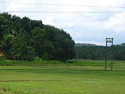
427:, Payyampally had a population of 12391 with 6276 males and 6115 females. 'Kuruva Island' the well known tourist place is situated in Payyampally. St Catherine's HSS, Govt. Higher Secondary School Arattuthara, Mary Matha Arts & Science College and St. Patrick's English Medium School are the main Educational institutions near Payyampally. The well known temple '
202:
169:
437:
the joining point of
Mananthavady river and Panamaram river is at Payyampally. The first migration in Wayanad is said to be took place at Payyampally in the years 1929-30 by Late. Mr. Devassya Kudakkachira. Tribes of Wayanad like Kurichiya, Pulaya, Adiya, Paniya and Kuruma are the majority population
446:
Payyampally can be accessed from
Mananthavady or Kalpetta. The Periya ghat road connects Mananthavady to Kannur and Thalassery. The Thamarassery mountain road connects Calicut with Kalpetta. The Kuttiady mountain road connects Vatakara with Kalpetta and Mananthavady. The Palchuram mountain road
554:
1041:
598:
1070:
558:
230:
1060:
447:
connects Kannur and Iritty with
Mananthavady. The road from Nilambur to Ooty is also connected to Wayanad through the village of Meppadi.
161:
108:
455:
451:
280:
1034:
591:
46:
194:
89:
459:
61:
42:
1065:
912:
776:
377:
292:
68:
726:
35:
1027:
584:
75:
839:
496:
57:
345:
144:
353:
325:
716:
691:
438:
of
Payyampally Village, In these Kurichiyas were the 'Army of Pazhassi Raja' against British.
1011:
999:
607:
408:
329:
297:
957:
889:
82:
756:
731:
641:
621:
428:
1054:
771:
370:
967:
819:
791:
751:
746:
736:
711:
626:
471:
396:
897:
874:
859:
844:
809:
781:
531:
24:
962:
879:
869:
854:
824:
814:
799:
761:
721:
696:
636:
501:
486:
481:
476:
245:
232:
952:
937:
932:
922:
849:
829:
766:
646:
511:
506:
491:
341:
336:
991:
947:
942:
741:
706:
701:
679:
651:
631:
521:
365:
927:
917:
902:
804:
683:
656:
516:
450:
The nearest railway station is at Mysore and the nearest airports are
1003:
907:
424:
412:
285:
557:. Registrar General & Census Commissioner, India. Archived from
576:
1007:
864:
555:"Census of India : Villages with population 5000 & above"
526:
395:
273:
580:
18:
1015:
888:
790:
678:
665:
614:
386:
376:
364:
352:
335:
321:
316:
308:
303:
291:
279:
261:
128:
49:. Unsourced material may be challenged and removed.
1035:
592:
549:
547:
8:
1042:
1028:
675:
599:
585:
577:
125:
109:Learn how and when to remove this message
543:
351:
334:
315:
302:
260:
225:
153:
141:
998:This article related to a location in
385:
375:
363:
320:
307:
290:
278:
7:
988:
986:
47:adding citations to reliable sources
201:
168:
1014:. You can help Knowledge (XXG) by
14:
1071:Wayanad district geography stubs
990:
266:
200:
193:
167:
160:
143:
23:
456:Bengaluru International Airport
452:Kozhikode International Airport
431:' is just 2 km away also '
34:needs additional citations for
1:
1061:Villages in Wayanad district
460:Kannur International Airport
1087:
985:
226:
181:Location in Kerala, India
154:
142:
135:
401:
399:
322: • Official
246:11.81111°N 76.05556°E
149:Oorpally, Payyampally
123:Town in Kerala, India
16:Town in Kerala, India
458:-290 km, and
378:Vehicle registration
43:improve this article
242: /
214:Payyampally (India)
561:on 8 December 2008
402:
400:Payyampalli Church
309: • Total
251:11.81111; 76.05556
184:Show map of Kerala
1066:Mananthavady Area
1023:
1022:
980:
979:
976:
975:
423:As of 2001 India
394:
393:
217:Show map of India
119:
118:
111:
93:
1078:
1044:
1037:
1030:
1000:Wayanad district
994:
987:
676:
615:Cities and towns
608:Wayanad district
601:
594:
587:
578:
571:
570:
568:
566:
551:
411:in the state of
409:Wayanad district
272:
270:
269:
257:
256:
254:
253:
252:
247:
243:
240:
239:
238:
235:
218:
204:
203:
197:
185:
171:
170:
164:
147:
126:
114:
107:
103:
100:
94:
92:
51:
27:
19:
1086:
1085:
1081:
1080:
1079:
1077:
1076:
1075:
1051:
1050:
1049:
1048:
983:
981:
972:
958:Sulthan Bathery
890:Sulthan Bathery
884:
786:
671:
669:
667:
661:
622:Sulthan Bathery
610:
605:
575:
574:
564:
562:
553:
552:
545:
540:
468:
444:
421:
360:
267:
265:
250:
248:
244:
241:
236:
233:
231:
229:
228:
222:
221:
220:
219:
216:
215:
212:
211:
210:
209:
205:
188:
187:
186:
183:
182:
179:
178:
177:
176:
172:
150:
138:
131:
124:
115:
104:
98:
95:
52:
50:
40:
28:
17:
12:
11:
5:
1084:
1082:
1074:
1073:
1068:
1063:
1053:
1052:
1047:
1046:
1039:
1032:
1024:
1021:
1020:
995:
978:
977:
974:
973:
971:
970:
965:
960:
955:
950:
945:
940:
935:
930:
925:
920:
915:
910:
905:
900:
894:
892:
886:
885:
883:
882:
877:
872:
867:
862:
857:
852:
847:
842:
837:
832:
827:
822:
817:
812:
807:
802:
796:
794:
788:
787:
785:
784:
779:
774:
769:
764:
759:
754:
749:
744:
739:
734:
732:Kunnathidavaka
729:
724:
719:
714:
709:
704:
699:
694:
688:
686:
673:
666:Sub-districts,
663:
662:
660:
659:
654:
649:
644:
642:Padinharethara
639:
634:
629:
624:
618:
616:
612:
611:
606:
604:
603:
596:
589:
581:
573:
572:
542:
541:
539:
536:
535:
534:
529:
524:
519:
514:
509:
504:
499:
494:
489:
484:
479:
474:
467:
464:
462:, 58 km.
454:-120 km,
443:
442:Transportation
440:
429:Valliyoor Kavu
420:
417:
392:
391:
388:
384:
383:
380:
374:
373:
368:
362:
361:
358:
356:
350:
349:
339:
333:
332:
323:
319:
318:
314:
313:
310:
306:
305:
301:
300:
295:
289:
288:
283:
277:
276:
263:
259:
258:
224:
223:
213:
207:
206:
199:
198:
192:
191:
190:
189:
180:
174:
173:
166:
165:
159:
158:
157:
156:
155:
152:
151:
148:
140:
139:
136:
133:
132:
129:
122:
117:
116:
31:
29:
22:
15:
13:
10:
9:
6:
4:
3:
2:
1083:
1072:
1069:
1067:
1064:
1062:
1059:
1058:
1056:
1045:
1040:
1038:
1033:
1031:
1026:
1025:
1019:
1017:
1013:
1009:
1005:
1001:
996:
993:
989:
984:
969:
966:
964:
961:
959:
956:
954:
951:
949:
946:
944:
941:
939:
936:
934:
931:
929:
926:
924:
921:
919:
916:
914:
911:
909:
906:
904:
901:
899:
896:
895:
893:
891:
887:
881:
878:
876:
873:
871:
868:
866:
863:
861:
858:
856:
853:
851:
848:
846:
843:
841:
838:
836:
833:
831:
828:
826:
823:
821:
818:
816:
813:
811:
808:
806:
803:
801:
798:
797:
795:
793:
789:
783:
780:
778:
775:
773:
772:Thrikkaipetta
770:
768:
765:
763:
760:
758:
757:Padijarethara
755:
753:
750:
748:
745:
743:
740:
738:
735:
733:
730:
728:
725:
723:
720:
718:
715:
713:
710:
708:
705:
703:
700:
698:
695:
693:
690:
689:
687:
685:
681:
677:
674:
664:
658:
655:
653:
650:
648:
645:
643:
640:
638:
635:
633:
630:
628:
625:
623:
620:
619:
617:
613:
609:
602:
597:
595:
590:
588:
583:
582:
579:
560:
556:
550:
548:
544:
537:
533:
530:
528:
525:
523:
520:
518:
515:
513:
510:
508:
505:
503:
500:
498:
495:
493:
490:
488:
485:
483:
480:
478:
475:
473:
470:
469:
465:
463:
461:
457:
453:
448:
441:
439:
436:
435:
434:Koodalkadavu'
430:
426:
418:
416:
414:
410:
407:is a town in
406:
398:
389:
381:
379:
372:
369:
367:
366:ISO 3166 code
357:
355:
347:
343:
340:
338:
331:
327:
324:
311:
299:
296:
294:
287:
284:
282:
275:
264:
255:
227:Coordinates:
196:
163:
146:
134:
127:
121:
113:
110:
102:
91:
88:
84:
81:
77:
74:
70:
67:
63:
60: –
59:
58:"Payyampally"
55:
54:Find sources:
48:
44:
38:
37:
32:This article
30:
26:
21:
20:
1016:expanding it
997:
982:
968:Thomattuchal
875:Cherukattoor
834:
820:Mananthavady
810:Kanjirangadu
792:Mananthavady
752:Muttil South
747:Muttil North
737:Kuppadithara
712:Kaniyambetta
627:Mananthavady
563:. Retrieved
559:the original
497:Vimala Nagar
472:Mananthavady
449:
445:
433:
432:
422:
419:Demographics
405:Payyampally
404:
403:
387:Nearest city
120:
105:
96:
86:
79:
72:
65:
53:
41:Please help
36:verification
33:
913:Krishnagiri
898:Ambalavayal
880:Thondernadu
860:Thrissilery
845:Porunnannur
835:Payyampally
825:Nalloornadu
777:Vellarimala
565:10 December
532:Thrissilery
390:manathavady
249: /
208:Payyampally
175:Payyampally
130:Payyampally
99:August 2018
1055:Categories
963:Kidanganad
870:Vellamunda
855:Thirunelly
815:Koolivayal
782:Vengapally
762:Pozhuthana
727:Kottathara
722:Kottappadi
717:Kavumannam
697:Achooranam
668:panchayats
637:Meenangadi
538:References
487:Nalloornad
482:Vellamunda
477:Thondernad
304:Population
234:11°48′40″N
69:newspapers
953:Purakkadi
938:Padichira
933:Noolpuzha
923:Nadavayal
850:Thavinjal
830:Panamaram
800:Anjukunnu
692:Mundakkai
647:Panamaram
512:Tharuvana
507:Panamaram
502:Anjukunnu
492:Thavinjal
415:, India.
337:Time zone
326:Malayalam
317:Languages
237:76°3′20″E
948:Pulpally
943:Poothadi
767:Thariode
742:Muppanad
707:Kalpetta
702:Chundale
680:Kalpetta
672:villages
652:Pulpally
632:Kalpetta
522:Oorpally
466:See also
342:UTC+5:30
293:District
928:Nenmeni
918:Kuppadi
903:Cheeral
805:Edavaka
684:Vythiri
657:Vythiri
517:Kallody
330:English
298:Wayanad
262:Country
83:scholar
1004:Kerala
908:Irulam
840:Periya
425:census
413:Kerala
359:670646
312:12,391
286:Kerala
271:
85:
78:
71:
64:
56:
1010:is a
1008:India
865:Valad
527:Valat
382:KL-72
371:IN-KL
281:State
274:India
90:JSTOR
76:books
1012:stub
567:2008
137:town
62:news
670:and
354:PIN
346:IST
45:by
1057::
1006:,
1002:,
546:^
328:,
1043:e
1036:t
1029:v
1018:.
682:/
600:e
593:t
586:v
569:.
348:)
344:(
112:)
106:(
101:)
97:(
87:·
80:·
73:·
66:·
39:.
Text is available under the Creative Commons Attribution-ShareAlike License. Additional terms may apply.