38:
49:
242:
186:
39:
1004:
313:
1061:
299:
420:
19:
452:
445:
282:
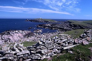
The name is derived from the
Shetland dialect words 'Peerie', meaning small, and 'Bard', meaning steep headland. The Muckle Bard, or large steep headland, is located on neighbouring Mousa.
438:
1136:
285:
The Mousa
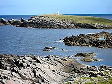
Lighthouse is located on the Peerie Bard. The lighthouse was first lit in 1951 and replaced one which had previously been located on the nearby headland of Noness
940:
857:
784:
670:
333:
1102:
1045:
362:
1121:
394:
1131:
1126:
1095:
1038:
328:
87:
48:
1088:
807:
570:
530:
625:
94:
1031:
832:
465:
978:
973:
930:
915:
709:
694:
585:
535:
963:
958:
910:
812:
774:
729:
520:
490:
895:
424:
925:
764:
734:
704:
660:
565:
550:
485:
689:
510:
505:
880:
837:
665:
620:
605:
525:
500:
495:
250:
241:
185:
968:
847:
779:
983:
875:
719:
318:
1003:
430:
852:
759:
610:
390:
1072:
1015:
650:
590:
269:
754:
595:
304:
1060:
749:
744:
724:
545:
515:
80:
312:
1115:
842:
540:
279:
Although named 'Perie Bard' on OS Maps, the name used in
Shetland is "Peerie Bard".
920:
635:
630:
615:
384:
950:
935:
699:
655:
580:
413:
1068:
769:
640:
600:
461:
294:
354:
109:
96:
905:
890:
885:
575:
560:
419:
1011:
867:
827:
822:
817:
802:
681:
473:
76:
72:
714:
645:
18:
794:
739:
166:
quadrangular tower covered by aluminium panels with light on the top
900:
555:
273:
68:
23:
17:
434:
272:. It is a small islet off the east coast of the island of
1076:
1019:
949:
866:
793:
679:
472:
249:
234:
226:
218:
210:
205:
193:
178:
170:
162:
154:
146:
138:
130:
125:
86:
62:
1096:
1039:
446:
334:List of Northern Lighthouse Board lighthouses
8:
33:
1137:United Kingdom building and structure stubs
363:University of North Carolina at Chapel Hill
1103:
1089:
1046:
1032:
453:
439:
431:
240:
238:10 nmi (19 km; 12 mi)
184:
47:
32:
345:
7:
1057:
1055:
1000:
998:
355:"Lighthouses of Scotland: Shetland"
1075:. You can help Knowledge (XXG) by
1018:. You can help Knowledge (XXG) by
14:
1059:
1002:
418:
311:
297:
37:
1122:Uninhabited islands of Shetland
329:List of lighthouses in Scotland
383:Haswell-Smith, Hamish (2004).
1:
1153:
1054:
997:
984:Thousla Rock (minor light)
1132:European lighthouse stubs
466:Northern Lighthouse Board
414:Northern Lighthouse Board
259:
201:
58:
46:
1127:Shetland geography stubs
389:. Edinburgh: Canongate.
359:The Lighthouse Directory
26:towards the Peerie Bard.
1071:-related article is a
1014:location article is a
969:Langness (minor light)
230:20 metres (66 ft)
110:59.997108°N 1.157808°W
27:
158:6 metres (20 ft)
21:
427:at Wikimedia Commons
386:The Scottish Islands
197:Mousa Nature Reserve
150:metal skeletal tower
115:59.997108; -1.157808
53:Eastern tip of Mousa
571:Holy Island (Outer)
106: /
43:
34:Mousa light station
926:Point of Fethaland
477:(except principal
319:Engineering portal
28:
22:The east coast of
1084:
1083:
1027:
1026:
992:
991:
843:Pentland Skerries
423:Media related to
396:978-1-84195-454-7
263:
262:
182:solar power
1144:
1105:
1098:
1091:
1063:
1056:
1048:
1041:
1034:
1006:
999:
823:Hoy Sound (High)
808:Brough of Birsay
591:Mull of Galloway
531:Covesea Skerries
455:
448:
441:
432:
422:
401:
400:
380:
374:
373:
371:
369:
350:
321:
316:
315:
307:
302:
301:
300:
270:Shetland Islands
245:
244:
189:
188:
121:
120:
118:
117:
116:
111:
107:
104:
103:
102:
99:
51:
44:
42:
41:
1152:
1151:
1147:
1146:
1145:
1143:
1142:
1141:
1112:
1111:
1110:
1109:
1053:
1052:
995:
993:
988:
945:
891:Fair Isle South
886:Fair Isle North
862:
833:North Ronaldsay
828:Hoy Sound (Low)
789:
755:Rona Lighthouse
710:Flannan Islands
675:
596:Mull of Kintyre
478:
476:
468:
459:
410:
405:
404:
397:
382:
381:
377:
367:
365:
353:Rowlett, Russ.
352:
351:
347:
342:
325:
324:
317:
310:
305:Scotland portal
303:
298:
296:
291:
239:
183:
114:
112:
108:
105:
100:
97:
95:
93:
92:
79:
75:
71:
67:
54:
35:
31:
12:
11:
5:
1150:
1148:
1140:
1139:
1134:
1129:
1124:
1114:
1113:
1108:
1107:
1100:
1093:
1085:
1082:
1081:
1064:
1051:
1050:
1043:
1036:
1028:
1025:
1024:
1007:
990:
989:
987:
986:
981:
976:
971:
966:
961:
955:
953:
947:
946:
944:
943:
938:
933:
928:
923:
918:
913:
908:
903:
898:
893:
888:
883:
878:
872:
870:
864:
863:
861:
860:
855:
850:
845:
840:
835:
830:
825:
820:
815:
810:
805:
799:
797:
791:
790:
788:
787:
782:
777:
772:
767:
762:
757:
752:
750:Rubha nan Gall
747:
745:Rinns of Islay
742:
737:
732:
727:
722:
717:
712:
707:
702:
697:
692:
686:
684:
677:
676:
674:
673:
668:
663:
658:
653:
648:
643:
638:
633:
628:
623:
618:
613:
608:
603:
598:
593:
588:
583:
578:
573:
568:
563:
558:
553:
548:
546:Duncansby Head
543:
538:
533:
528:
523:
518:
513:
508:
503:
498:
493:
488:
482:
480:
479:island groups)
470:
469:
460:
458:
457:
450:
443:
435:
429:
428:
416:
409:
408:External links
406:
403:
402:
395:
375:
344:
343:
341:
338:
337:
336:
331:
323:
322:
308:
293:
292:
290:
287:
268:is one of the
261:
260:
257:
256:
253:
251:Characteristic
247:
246:
236:
232:
231:
228:
224:
223:
220:
216:
215:
214:2000 (current)
212:
208:
207:
203:
202:
199:
198:
195:
191:
190:
180:
176:
175:
172:
168:
167:
164:
160:
159:
156:
152:
151:
148:
144:
143:
140:
136:
135:
132:
128:
127:
123:
122:
90:
84:
83:
81:United Kingdom
64:
60:
59:
56:
55:
52:
29:
13:
10:
9:
6:
4:
3:
2:
1149:
1138:
1135:
1133:
1130:
1128:
1125:
1123:
1120:
1119:
1117:
1106:
1101:
1099:
1094:
1092:
1087:
1086:
1080:
1078:
1074:
1070:
1067:This British
1065:
1062:
1058:
1049:
1044:
1042:
1037:
1035:
1030:
1029:
1023:
1021:
1017:
1013:
1008:
1005:
1001:
996:
985:
982:
980:
979:Point of Ayre
977:
975:
974:Maughold Head
972:
970:
967:
965:
962:
960:
957:
956:
954:
952:
948:
942:
939:
937:
934:
932:
931:Sumburgh Head
929:
927:
924:
922:
919:
917:
916:Muckle Flugga
914:
912:
909:
907:
904:
902:
899:
897:
894:
892:
889:
887:
884:
882:
879:
877:
874:
873:
871:
869:
865:
859:
856:
854:
851:
849:
846:
844:
841:
839:
836:
834:
831:
829:
826:
824:
821:
819:
816:
814:
811:
809:
806:
804:
801:
800:
798:
796:
792:
786:
783:
781:
778:
776:
773:
771:
768:
766:
763:
761:
758:
756:
753:
751:
748:
746:
743:
741:
738:
736:
733:
731:
728:
726:
723:
721:
718:
716:
713:
711:
708:
706:
703:
701:
698:
696:
695:Butt of Lewis
693:
691:
688:
687:
685:
683:
678:
672:
669:
667:
664:
662:
659:
657:
654:
652:
649:
647:
646:Strathy Point
644:
642:
639:
637:
634:
632:
629:
627:
624:
622:
619:
617:
614:
612:
609:
607:
604:
602:
599:
597:
594:
592:
589:
587:
586:Kinnaird Head
584:
582:
579:
577:
574:
572:
569:
567:
564:
562:
559:
557:
554:
552:
549:
547:
544:
542:
539:
537:
534:
532:
529:
527:
524:
522:
519:
517:
514:
512:
509:
507:
504:
502:
499:
497:
494:
492:
489:
487:
484:
483:
481:
475:
471:
467:
463:
456:
451:
449:
444:
442:
437:
436:
433:
426:
421:
417:
415:
412:
411:
407:
398:
392:
388:
387:
379:
376:
364:
360:
356:
349:
346:
339:
335:
332:
330:
327:
326:
320:
314:
309:
306:
295:
288:
286:
283:
280:
277:
275:
271:
267:
258:
254:
252:
248:
243:
237:
233:
229:
225:
221:
217:
213:
209:
204:
200:
196:
192:
187:
181:
177:
173:
169:
165:
161:
157:
153:
149:
145:
142:concrete base
141:
137:
133:
129:
124:
119:
91:
89:
85:
82:
78:
74:
70:
65:
61:
57:
50:
45:
40:
25:
20:
16:
1077:expanding it
1066:
1020:expanding it
1009:
994:
964:Douglas Head
959:Chicken Rock
941:Minor lights
921:Out Skerries
858:Minor lights
813:Cantick Head
785:Minor lights
775:Tiumpan Head
671:Minor lights
636:Scurdie Ness
626:St Abbs Head
616:Rattray Head
536:Crammag Head
521:Corran Point
491:Ardnamurchan
385:
378:
366:. Retrieved
358:
348:
284:
281:
278:
265:
264:
227:Focal height
222:2000 (first)
179:Power source
147:Construction
134:1951 (first)
15:
951:Isle of Man
936:Ve Skerries
911:Little Holm
848:Start Point
735:Neist Point
705:Eilean Glas
700:Dubh Artach
661:Tarbat Ness
656:Sule Skerry
581:Isle of May
566:Girdle Ness
551:Dunnet Head
506:Buchan Ness
486:Ailsa Craig
462:Lighthouses
425:Peerie Bard
219:Deactivated
174:white tower
131:Constructed
113: /
88:Coordinates
66:Peerie Bard
1116:Categories
1069:lighthouse
896:Firths Voe
770:Skerryvore
690:Barra Head
641:Stoer Head
601:North Rona
511:Cape Wrath
340:References
266:Perie Bard
139:Foundation
98:59°59′50″N
30:Lighthouse
906:Hoo Stack
838:Noup Head
765:Scarinish
666:Turnberry
606:Noss Head
576:Inchkeith
561:Fife Ness
526:Corsewall
501:Bell Rock
496:Bass Rock
211:First lit
101:1°09′28″W
1012:Shetland
881:Eshaness
868:Shetland
853:Tor Ness
818:Copinsay
803:Auskerry
780:Ushenish
682:Hebrides
516:Chanonry
474:Scotland
289:See also
255:Fl W 3s.
194:Operator
171:Markings
77:Scotland
73:Shetland
63:Location
876:Bressay
725:Lismore
720:Hyskeir
715:Haskeir
621:Rubh Re
464:of the
795:Orkney
760:Ruvaal
740:Ornsay
730:Monach
651:Stroma
611:Pladda
541:Davaar
393:
368:31 May
155:Height
1010:This
901:Foula
631:Sanda
556:Fidra
274:Mousa
235:Range
206:Light
163:Shape
126:Tower
69:Mousa
36:
24:Mousa
1073:stub
1016:stub
680:The
391:ISBN
370:2016
1118::
361:.
357:.
276:.
1104:e
1097:t
1090:v
1079:.
1047:e
1040:t
1033:v
1022:.
454:e
447:t
440:v
399:.
372:.
Text is available under the Creative Commons Attribution-ShareAlike License. Additional terms may apply.