31:
133:
237:
281:
208:
Nuttall, John & Anne (1999). The
Mountains of England & Wales - Volume 1: Wales (2nd edition ed.). Milnthorpe, Cumbria: Cicerone.
213:
286:
127:
166:
116:
69:
59:
81:
276:
209:
181:
162:
74:
35:
146:
141:
101:
86:
270:
189:
185:
229:
120:
180:
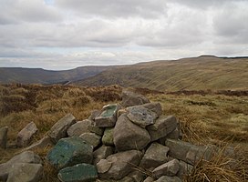
The summit is marked by a pile of stones in an area of sandy soil and heather.
252:
239:
174:
49:
30:
230:
www.geograph.co.uk : photos of Waun Fach and surrounding area
170:
140:
126:
112:
107:
97:
92:
80:
68:
58:
48:
43:
23:
173:. It lies on one of the many south ridges of
8:
20:
201:
7:
14:
38:from the summit of Pen Twyn Mawr
29:
1:
282:Mountains and hills of Powys
16:Hill (658m) in Powys, Wales
303:
54:658 m (2,159 ft)
28:
287:Black Mountains, Wales
64:17 m (56 ft)
253:51.96292°N 3.14392°W
249: /
258:51.96292; -3.14392
44:Highest point
184:is to the north,
182:Pen y Gadair Fawr
169:in south-eastern
163:Pen y Gadair Fawr
156:
155:
75:Pen y Gadair Fawr
36:Pen y Gadair Fawr
294:
264:
263:
261:
260:
259:
254:
250:
247:
246:
245:
242:
217:
206:
188:to the east and
136:
98:Language of name
33:
21:
302:
301:
297:
296:
295:
293:
292:
291:
267:
266:
257:
255:
251:
248:
243:
240:
238:
236:
235:
226:
221:
220:
207:
203:
198:
167:Black Mountains
132:
117:Black Mountains
39:
17:
12:
11:
5:
300:
298:
290:
289:
284:
279:
269:
268:
233:
232:
225:
224:External links
222:
219:
218:
200:
199:
197:
194:
154:
153:
144:
138:
137:
130:
124:
123:
114:
110:
109:
105:
104:
99:
95:
94:
90:
89:
84:
78:
77:
72:
66:
65:
62:
56:
55:
52:
46:
45:
41:
40:
34:
26:
25:
15:
13:
10:
9:
6:
4:
3:
2:
299:
288:
285:
283:
280:
278:
275:
274:
272:
265:
262:
231:
228:
227:
223:
215:
214:1-85284-304-7
211:
205:
202:
195:
193:
192:to the west.
191:
190:Pen Allt-mawr
187:
186:Chwarel y Fan
183:
178:
176:
172:
168:
164:
160:
159:Pen Twyn Mawr
151:
148:
145:
143:
139:
135:
131:
129:
125:
122:
118:
115:
111:
106:
103:
100:
96:
91:
88:
85:
83:
79:
76:
73:
71:
67:
63:
61:
57:
53:
51:
47:
42:
37:
32:
27:
24:Pen Twyn Mawr
22:
19:
234:
204:
179:
161:is a top of
158:
157:
149:
18:
256: /
121:South Wales
70:Parent peak
271:Categories
241:51°57′47″N
196:References
150:Landranger
60:Prominence
244:3°08′38″W
175:Waun Fach
108:Geography
50:Elevation
277:Nuttalls
142:Topo map
134:SO241266
113:Location
165:in the
128:OS grid
87:Nuttall
82:Listing
212:
93:Naming
171:Wales
102:Welsh
210:ISBN
152:161
273::
177:.
147:OS
119:,
216:.
Text is available under the Creative Commons Attribution-ShareAlike License. Additional terms may apply.