270:. It is about 3 miles long from east to west and about 2 miles wide. There is a bay on the northern side of the island, but it has not been investigated. The shores of Astrolabe Island are foul close-to. A foul area extends from the northwestern extremity of the island for a distance of about 1 mile in a northerly direction, and the foul area is charted continuing to a point about 2 1/2 miles northward of the island. An above-water rock lies approximately 2 miles west-northwest of the northwestern extremity of the island.
56:
210:
442:. A 400 metres (1,300 ft) wide cove indenting the east coast of Astrolabe Island by 680 metres (2,230 ft). Centred 2.6 kilometres (1.6 mi) southeast of Kanarata Point, 700 metres (2,300 ft) southwest of Papazov Island and 3.3 kilometres (2.1 mi) northeast of Sherrell Point. Surmounted by Drumohar Peak on the northwest and Rogach Peak on the south. Named after
40:
882:. A rocky island lying off the northeast coast of Astrolabe Island, 250 metres (820 ft) long in a southeast–northwest direction and 100 metres (330 ft) wide. Situated 90 metres (300 ft) northeast of Kanarata Point, 460 metres (1,510 ft) north-northwest of Sagita Island and 2.08 kilometres (1.29 mi) north-northeast of Drumohar Peak. Named after
975:. A rocky island lying off the entrance to Velcha Cove on the east coast of Astrolabe Island, 200 metres (660 ft) long in a west.southwest – east-northeast direction and 100 metres (330 ft) wide. Situated 2.27 kilometres (1.41 mi) southeast of Kanarata Point and 1.4 kilometres (0.87 mi) east of Drumohar Peak. Named after the Bulgarian-French artist
63:
309:
1610:
1555:
1316:
932:. A rocky island lying off the northeast coast of Astrolabe Island, 280 metres (920 ft) long in a southwest–northeast direction and 180 metres (590 ft) wide. Situated 710 metres (2,330 ft) southeast of Kanarata Point and 1.64 kilometres (1.02 mi) northeast of Drumohar Peak. Named after the ocean fishing trawler
702:. An ice-covered hill rising to 381 metres (1,250 ft) high in northwestern Astrolabe Island. Situated 1.2 kilometres (0.75 mi) northeast of Damga Point, 1.32 kilometres (0.82 mi) southeast of Raduil Point and 2.15 kilometres (1.34 mi) west of Drumohar Peak. Surmounts Mokren Bight to the south. Named after
790:. The ice-covered peak rising to Raduil Point 562 metres (1,844 ft) high on Astrolabe Island, summit of the island. Situated 2.28 kilometres (1.42 mi) northeast of Sherell Point and 1.9 kilometres (1.2 mi) south-southeast of Drumohar Peak. German-British mapping in 1996. Named after the settlement of
748:. The ice-covered peak rising to 437 metres (1,434 ft) high on Astrolabe Island in Graham Land. Situated 3.15 kilometres (1.96 mi) east-northeast of Raduil Point and 1.9 kilometres (1.2 mi) north-northwest of Rogach Peak. German-British mapping in 1996. Named after the settlement of
936:
of the
Bulgarian company Ocean Fisheries – Burgas that operated in Antarctic waters off South Georgia during its fishing trips under Captain Ivan Krastanov from February 1978 to July 1978, and under Captain Yordan Yordanov from December 1979 to June 1980. Apart from fishing, on the latter occasion
273:
A group of three islets, surrounded by foul ground, lies with the westernmost of the group in a position about 3 1/2 miles east-southeastward of the eastern extremity of
Astrolabe Island. A depth of 10 fathoms is charted about 1 1/2 miles westward of the westernmost islet. A rock, awash, is charted
249:
Astrolabe Island is predominantly volcanic rocks, with coarse grained mafic dolerite making up most of the landing site on the east end. The steep pyramid peaks, called the
Dragons Teeth, may be the vents of an old volcanic complex, probably related to the Shetland subduction zone to the north.
568:. A sharp rocky northwest entrance point of Mokren Bight on the west coast of Astrolabe Island. Situated 1.58 kilometres (0.98 mi) south of Raduil Point, 1.2 kilometres (0.75 mi) southwest of Petleshkov Hill and 3.1 kilometres (1.9 mi) northwest of Sherrell Point. Named after
1570:
400:. A rocky point in northeastern Astrolabe Island forming the north extremity of the island surmounted by Dragons Teeth. Situated 3.95 kilometres (2.45 mi) northeast of Raduil Point and 2.17 kilometres (1.35 mi) north of Drumohar Peak. Named after Kanarata Peak in
484:. A point on the west coast of Astrolabe Island. Situated 1.15 kilometres (0.71 mi) northwest of Sherrell Point and 3.35 kilometres (2.08 mi) southeast of Raduil Point. Forming the southeast side of the entrance to Mokren Bight. Named after the settlement of
1579:
1614:
1559:
1320:
614:. The point forming the northwest extremity of Astrolabe Island. Situated 4.5 kilometres (2.8 mi) northwest of Sherrell Point. Named after the settlement of Raduil in Southwestern Bulgaria.
653:
294:
526:. A 2 kilometres (1.2 mi) wide embayment indenting the west coast of Astrolabe Island for 850 metres (2,790 ft). Entered north of Gega Point. Named after the settlement of
1600:
1528:
1511:
1494:
1477:
1460:
1443:
1426:
1409:
1375:
1358:
1341:
104:
1563:
1324:
152:
1638:
55:
312:
841:
1595:
1523:
1506:
1489:
1472:
1455:
1438:
1421:
1404:
1370:
1353:
1336:
1648:
1618:
652:. A point at the south end of Astrolabe Island. Named for Frederick W. Sherrell, surveyor and geologist in this area with the
1578:(Scale 1:250000 topographic map No. 5697), Institut für Angewandte Geodäsie and British Antarctic Survey, 1996, archived from
44:
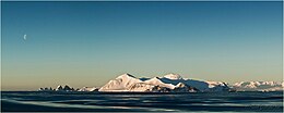
Astrolabe Island from northwest, with the
Dragons Teeth on the left, and Drumohar Peak and Rogach Peak dominating the island.
372:
947:
904:
854:
762:
720:
674:
586:
540:
498:
456:
414:
1018:
289:
1643:
989:
812:
624:
1017:. The largest of several rocks close north of the west end of Astrolabe Island. The name was given by the first
706:(1845-1876), a leader of the 1876 April Uprising for Bulgarian independence, in connection with the settlement of
324:
1633:
284:
266:
Astrolabe Island, about 1,850 feet high, lies about 9 miles from the coast and about 19 miles southwestward of
1541:
1590:
1518:
1501:
1484:
1467:
1450:
1433:
1416:
1399:
1365:
1348:
1331:
351:
703:
346:
1382:
883:
238:
230:
887:
840:. A small group of rocks off the northeast part of Astrolabe Island. The name, applied by the
341:
1535:
234:
222:
198:
190:
527:
443:
226:
1195:
976:
485:
267:
1627:
1297:
194:
283:
Astrolabe Island was discovered by the French expedition, 1837–40, under
Captain
707:
336:
218:
209:
39:
17:
189:) is an island 3 nautical miles (5.6 km; 3.5 mi) long, lying in the
92:
1004:
991:
962:
949:
919:
906:
869:
856:
827:
814:
777:
764:
735:
722:
689:
676:
639:
626:
601:
588:
555:
542:
513:
500:
471:
458:
429:
416:
387:
374:
168:
154:
120:
106:
1537:
Sailing
Directions for Antarctica: Includes Islands South of Latitude 60.̊
749:
213:
Trinity
Peninsula, Antarctic Peninsula. Astrolabe Island to the northwest
937:
the ship carried out fisheries research by an onboard scientific team.
791:
308:
293:. The island was photographed from the air and triangulated by the
274:
about 8 miles southwestward of the western end of
Astrolabe Island.
241:. Features include Sherell Point, Diaz Rock and the Dragons Teeth.
569:
208:
1171:
891:
573:
401:
1051:
844:(UK-APC), is descriptive of these black tooth-shaped rocks.
802:
Nearby rocks and islands include, clockwise from the north,
654:
Falkland
Islands and Dependencies Aerial Survey Expedition
295:
Falkland
Islands and Dependencies Aerial Survey Expedition
1063:
193:
14 nautical miles (26 km; 16 mi) northwest of
1035:
1033:
1198:
Polar Geospatial Center. University of Minnesota, 2019
1174:
Polar Geospatial Center. University of Minnesota, 2022
287:, and named by him for his chief expedition ship, the
1305:(2 ed.), United States Board on Geographic Names
362:
Coastal features include, clockwise from the north:
1075:
98:
88:
83:
1021:(1947) for sub-lieutenant Joaquin Diaz Martinez.
1183:
1267:
1087:
264:
1255:
1243:
1207:
262:(1976) describes Astrolabe Island as follows:
1147:
1123:
664:Inland features, from west to east, include:
8:
1219:
1135:
1099:
32:
1111:
1601:Scientific Committee on Antarctic Research
1529:Scientific Committee on Antarctic Research
1512:Scientific Committee on Antarctic Research
1495:Scientific Committee on Antarctic Research
1478:Scientific Committee on Antarctic Research
1461:Scientific Committee on Antarctic Research
1444:Scientific Committee on Antarctic Research
1427:Scientific Committee on Antarctic Research
1410:Scientific Committee on Antarctic Research
1376:Scientific Committee on Antarctic Research
1359:Scientific Committee on Antarctic Research
1342:Scientific Committee on Antarctic Research
38:
31:
1196:Reference Elevation Model of Antarctica.
1172:Reference Elevation Model of Antarctica.
62:
1564:National Geospatial-Intelligence Agency
1325:United States Board on Geographic Names
1279:
1231:
1159:
1039:
1029:
1384:Graham Land and South Shetland Islands
1387:, BAS: British Antarctic Survey, 2005
7:
1617:from websites or documents of the
1562:from websites or documents of the
1323:from websites or documents of the
1052:Graham Land and South Shetland BAS
842:UK Antarctic Place-Names Committee
446:Peak in Eastern Balkan Mountains.
25:
1596:Composite Gazetteer of Antarctica
1524:Composite Gazetteer of Antarctica
1507:Composite Gazetteer of Antarctica
1490:Composite Gazetteer of Antarctica
1473:Composite Gazetteer of Antarctica
1456:Composite Gazetteer of Antarctica
1439:Composite Gazetteer of Antarctica
1422:Composite Gazetteer of Antarctica
1405:Composite Gazetteer of Antarctica
1371:Composite Gazetteer of Antarctica
1354:Composite Gazetteer of Antarctica
1337:Composite Gazetteer of Antarctica
1299:Geographic Names of the Antarctic
313:Copernix annotated satellite view
260:Sailing Directions for Antarctica
237:, which itself is the tip of the
27:Island in Graham Land, Antarctica
1613: This article incorporates
1608:
1558: This article incorporates
1553:
1319: This article incorporates
1314:
307:
258:The US Defense Mapping Agency's
61:
54:
1619:United States Geological Survey
1296:Alberts, Fred G., ed. (1995),
1:
225:to the west-northwest of the
1639:Islands of Trinity Peninsula
1064:Trinity Peninsula AG and BAS
1019:Chilean Antarctic Expedition
1544:. Hydrographic Center, 1976
352:GPX (secondary coordinates)
1665:
710:in Northeastern Bulgaria.
530:in Southeastern Bulgaria.
488:in Southwestern Bulgaria.
233:on the north coast of the
347:GPX (primary coordinates)
322:Map all coordinates using
49:
37:
1078:, p. 140, Sec. 4-3.
330:Download coordinates as:
1076:Sailing Directions 1976
217:Astrolabe Island is in
1649:Islands of Graham Land
1615:public domain material
1560:public domain material
1542:Defense Mapping Agency
1321:public domain material
794:in Southern Bulgaria.
388:63.287861°S 58.67833°W
285:Jules Dumont d'Urville
276:
214:
75:Location in Antarctica
963:63.30528°S 58.65333°W
920:63.29306°S 58.66667°W
870:63.28806°S 58.67472°W
778:63.32194°S 58.66250°W
752:in Western Bulgaria.
736:63.30722°S 58.68194°W
690:63.30972°S 58.72500°W
602:63.30389°S 58.74861°W
556:63.31778°S 58.74139°W
514:63.32056°S 58.71889°W
472:63.32750°S 58.70611°W
430:63.31028°S 58.66472°W
393:-63.287861; -58.67833
342:GPX (all coordinates)
297:(FIDASE) in 1956–57.
212:
1585:on 23 September 2015
1184:Petleshkov Hill SCAR
968:-63.30528; -58.65333
925:-63.29306; -58.66667
894:Mountain, Bulgaria.
875:-63.28806; -58.67472
783:-63.32194; -58.66250
741:-63.30722; -58.68194
695:-63.30972; -58.72500
607:-63.30389; -58.74861
576:Mountain, Bulgaria.
561:-63.31778; -58.74139
519:-63.32056; -58.71889
477:-63.32750; -58.70611
435:-63.31028; -58.66472
404:Mountain, Bulgaria.
1268:Papazov Island SCAR
1088:Kanarata Point SCAR
1001: /
959: /
916: /
866: /
824: /
774: /
732: /
686: /
656:(FIDASE), 1955-56.
636: /
598: /
552: /
510: /
468: /
426: /
384: /
239:Antarctic Peninsula
231:Cockerell Peninsula
164: /
116: /
34:
1256:Sagita Island SCAR
1244:Polich Island SCAR
1208:Drumohar Peak SCAR
279:Discovery and name
254:Sailing directions
215:
1644:Trinity Peninsula
1572:Trinity Peninsula
1540:, United States.
1451:"Petleshkov Hill"
1148:Raduil Point SCAR
1124:Mokren Bight SCAR
1005:63.300°S 58.750°W
640:63.300°S 58.683°W
235:Trinity Peninsula
223:Bransfield Strait
221:. It lies in the
199:Trinity Peninsula
191:Bransfield Strait
169:63.283°S 58.667°W
144:
143:
121:63.283°S 58.667°W
16:(Redirected from
1656:
1634:Astrolabe Island
1612:
1611:
1603:
1586:
1584:
1577:
1557:
1556:
1552:
1551:
1549:
1531:
1514:
1497:
1480:
1463:
1446:
1434:"Papazov Island"
1429:
1412:
1400:"Kanarata Point"
1395:
1394:
1392:
1378:
1361:
1344:
1318:
1317:
1313:
1312:
1310:
1304:
1283:
1277:
1271:
1265:
1259:
1253:
1247:
1241:
1235:
1229:
1223:
1220:Rogach Peak SCAR
1217:
1211:
1205:
1199:
1193:
1187:
1181:
1175:
1169:
1163:
1157:
1151:
1145:
1139:
1136:Damga Point SCAR
1133:
1127:
1121:
1115:
1109:
1103:
1100:Velcha Cove SCAR
1097:
1091:
1085:
1079:
1073:
1067:
1061:
1055:
1049:
1043:
1037:
1016:
1015:
1013:
1012:
1011:
1010:-63.300; -58.750
1006:
1002:
999:
998:
997:
994:
974:
973:
971:
970:
969:
964:
960:
957:
956:
955:
952:
931:
930:
928:
927:
926:
921:
917:
914:
913:
912:
909:
881:
880:
878:
877:
876:
871:
867:
864:
863:
862:
859:
839:
838:
836:
835:
834:
829:
825:
822:
821:
820:
817:
789:
788:
786:
785:
784:
779:
775:
772:
771:
770:
767:
747:
746:
744:
743:
742:
737:
733:
730:
729:
728:
725:
704:Vasil Petleshkov
701:
700:
698:
697:
696:
691:
687:
684:
683:
682:
679:
651:
650:
648:
647:
646:
645:-63.300; -58.683
641:
637:
634:
633:
632:
629:
613:
612:
610:
609:
608:
603:
599:
596:
595:
594:
591:
567:
566:
564:
563:
562:
557:
553:
550:
549:
548:
545:
525:
524:
522:
521:
520:
515:
511:
508:
507:
506:
503:
483:
482:
480:
479:
478:
473:
469:
466:
465:
464:
461:
441:
440:
438:
437:
436:
431:
427:
424:
423:
422:
419:
399:
398:
396:
395:
394:
389:
385:
382:
381:
380:
377:
311:
301:Coastal features
227:Tupinier Islands
188:
187:
185:
184:
183:
181:
180:Astrolabe Island
176:
175:
174:-63.283; -58.667
170:
165:
162:
161:
160:
157:
147:Astrolabe Island
140:
139:
137:
136:
135:
133:
132:Astrolabe Island
128:
127:
126:-63.283; -58.667
122:
117:
114:
113:
112:
109:
69:Astrolabe Island
65:
64:
58:
42:
35:
33:Astrolabe Island
21:
1664:
1663:
1659:
1658:
1657:
1655:
1654:
1653:
1624:
1623:
1609:
1606:
1589:
1582:
1575:
1569:
1554:
1547:
1545:
1534:
1519:"Sagita Island"
1517:
1500:
1483:
1468:"Polich Island"
1466:
1449:
1432:
1415:
1398:
1390:
1388:
1381:
1364:
1349:"Drumohar Peak"
1347:
1330:
1315:
1308:
1306:
1302:
1295:
1291:
1286:
1278:
1274:
1266:
1262:
1254:
1250:
1242:
1238:
1230:
1226:
1218:
1214:
1206:
1202:
1194:
1190:
1182:
1178:
1170:
1166:
1158:
1154:
1146:
1142:
1134:
1130:
1122:
1118:
1112:Gega Point SCAR
1110:
1106:
1098:
1094:
1086:
1082:
1074:
1070:
1062:
1058:
1050:
1046:
1038:
1031:
1027:
1009:
1007:
1003:
1000:
995:
992:
990:
988:
987:
985:
967:
965:
961:
958:
953:
950:
948:
946:
945:
943:
924:
922:
918:
915:
910:
907:
905:
903:
902:
900:
874:
872:
868:
865:
860:
857:
855:
853:
852:
850:
832:
830:
828:63.25°S 58.65°W
826:
823:
818:
815:
813:
811:
810:
808:
800:
782:
780:
776:
773:
768:
765:
763:
761:
760:
758:
740:
738:
734:
731:
726:
723:
721:
719:
718:
716:
694:
692:
688:
685:
680:
677:
675:
673:
672:
670:
668:Petleshkov Hill
662:
660:Inland features
644:
642:
638:
635:
630:
627:
625:
623:
622:
620:
606:
604:
600:
597:
592:
589:
587:
585:
584:
582:
560:
558:
554:
551:
546:
543:
541:
539:
538:
536:
518:
516:
512:
509:
504:
501:
499:
497:
496:
494:
476:
474:
470:
467:
462:
459:
457:
455:
454:
452:
434:
432:
428:
425:
420:
417:
415:
413:
412:
410:
392:
390:
386:
383:
378:
375:
373:
371:
370:
368:
360:
359:
358:
357:
356:
317:
316:
315:
303:
281:
256:
247:
207:
201:in Antarctica.
179:
177:
173:
171:
167:
166:
163:
158:
155:
153:
151:
150:
131:
129:
125:
123:
119:
118:
115:
110:
107:
105:
103:
102:
79:
78:
77:
76:
73:
72:
71:
70:
66:
45:
28:
23:
22:
18:Petleshkov Hill
15:
12:
11:
5:
1662:
1660:
1652:
1651:
1646:
1641:
1636:
1626:
1625:
1605:
1604:
1587:
1567:
1532:
1515:
1498:
1485:"Raduil Point"
1481:
1464:
1447:
1430:
1417:"Mokren Bight"
1413:
1396:
1379:
1362:
1345:
1328:
1292:
1290:
1287:
1285:
1284:
1282:, p. 188.
1272:
1260:
1248:
1236:
1234:, p. 199.
1224:
1212:
1200:
1188:
1176:
1164:
1162:, p. 670.
1152:
1140:
1128:
1116:
1104:
1092:
1080:
1068:
1056:
1044:
1028:
1026:
1023:
984:
981:
977:George Papazov
942:
941:Papazov Island
939:
899:
896:
849:
846:
833:-63.25; -58.65
807:
804:
799:
798:Nearby islands
796:
757:
754:
715:
712:
669:
666:
661:
658:
619:
616:
581:
578:
535:
532:
493:
490:
451:
448:
409:
406:
367:
366:Kanarata Point
364:
355:
354:
349:
344:
339:
333:
327:
320:
319:
318:
306:
305:
304:
302:
299:
280:
277:
268:Montravel Rock
255:
252:
246:
243:
206:
203:
142:
141:
100:
96:
95:
90:
86:
85:
81:
80:
74:
68:
67:
60:
59:
53:
52:
51:
50:
47:
46:
43:
26:
24:
14:
13:
10:
9:
6:
4:
3:
2:
1661:
1650:
1647:
1645:
1642:
1640:
1637:
1635:
1632:
1631:
1629:
1622:
1620:
1616:
1602:
1598:
1597:
1592:
1591:"Velcha Cove"
1588:
1581:
1574:
1573:
1568:
1565:
1561:
1543:
1539:
1538:
1533:
1530:
1526:
1525:
1520:
1516:
1513:
1509:
1508:
1503:
1502:"Rogach Peak"
1499:
1496:
1492:
1491:
1486:
1482:
1479:
1475:
1474:
1469:
1465:
1462:
1458:
1457:
1452:
1448:
1445:
1441:
1440:
1435:
1431:
1428:
1424:
1423:
1418:
1414:
1411:
1407:
1406:
1401:
1397:
1386:
1385:
1380:
1377:
1373:
1372:
1367:
1363:
1360:
1356:
1355:
1350:
1346:
1343:
1339:
1338:
1333:
1332:"Damga Point"
1329:
1326:
1322:
1301:
1300:
1294:
1293:
1288:
1281:
1276:
1273:
1269:
1264:
1261:
1257:
1252:
1249:
1245:
1240:
1237:
1233:
1228:
1225:
1221:
1216:
1213:
1209:
1204:
1201:
1197:
1192:
1189:
1185:
1180:
1177:
1173:
1168:
1165:
1161:
1156:
1153:
1149:
1144:
1141:
1137:
1132:
1129:
1125:
1120:
1117:
1113:
1108:
1105:
1101:
1096:
1093:
1089:
1084:
1081:
1077:
1072:
1069:
1065:
1060:
1057:
1053:
1048:
1045:
1042:, p. 31.
1041:
1036:
1034:
1030:
1024:
1022:
1020:
1014:
982:
980:
979:(1894-1972).
978:
972:
940:
938:
935:
929:
898:Sagita Island
897:
895:
893:
889:
885:
884:Golyam Polich
879:
848:Polich Island
847:
845:
843:
837:
806:Dragons Teeth
805:
803:
797:
795:
793:
787:
755:
753:
751:
745:
714:Drumohar Peak
713:
711:
709:
705:
699:
667:
665:
659:
657:
655:
649:
618:Sherell Point
617:
615:
611:
579:
577:
575:
571:
565:
533:
531:
529:
523:
491:
489:
487:
481:
449:
447:
445:
439:
407:
405:
403:
397:
365:
363:
353:
350:
348:
345:
343:
340:
338:
335:
334:
332:
331:
326:
325:OpenStreetMap
323:
314:
310:
300:
298:
296:
292:
291:
286:
278:
275:
271:
269:
263:
261:
253:
251:
244:
242:
240:
236:
232:
228:
224:
220:
211:
204:
202:
200:
196:
192:
186:
148:
138:
101:
97:
94:
91:
87:
82:
57:
48:
41:
36:
30:
19:
1607:
1594:
1580:the original
1571:
1546:, retrieved
1536:
1522:
1505:
1488:
1471:
1454:
1437:
1420:
1403:
1389:, retrieved
1383:
1369:
1366:"Gega Point"
1352:
1335:
1307:, retrieved
1298:
1280:Alberts 1995
1275:
1263:
1251:
1239:
1232:Alberts 1995
1227:
1215:
1203:
1191:
1179:
1167:
1160:Alberts 1995
1155:
1143:
1131:
1119:
1107:
1095:
1083:
1071:
1059:
1047:
1040:Alberts 1995
986:
944:
933:
901:
888:Malak Polich
851:
809:
801:
759:
717:
671:
663:
621:
583:
580:Raduil Point
537:
495:
492:Mokren Bight
453:
411:
376:63°17′16.3″S
369:
361:
329:
328:
321:
288:
282:
272:
265:
259:
257:
248:
216:
195:Cape Ducorps
146:
145:
29:
1008: /
966: /
923: /
873: /
831: /
781: /
756:Rogach Peak
739: /
708:Petleshkovo
693: /
643: /
605: /
559: /
534:Damga Point
517: /
475: /
433: /
408:Velcha Cove
391: /
219:Graham Land
172: /
124: /
99:Coordinates
1628:Categories
1309:3 December
1025:References
954:58°39′12″W
951:63°18′19″S
911:58°40′00″W
908:63°17′35″S
861:58°40′29″W
858:63°17′17″S
769:58°39′45″W
766:63°19′19″S
727:58°40′55″W
724:63°18′26″S
681:58°43′30″W
678:63°18′35″S
593:58°44′55″W
590:63°18′14″S
547:58°44′29″W
544:63°19′04″S
505:58°43′08″W
502:63°19′14″S
463:58°42′22″W
460:63°19′39″S
450:Gega Point
421:58°39′53″W
418:63°18′37″S
379:58°40′42″W
178: (
130: (
93:Antarctica
983:Diaz Rock
890:Peaks in
290:Astrolabe
84:Geography
750:Drumohar
572:Peak in
229:and the
205:Location
89:Location
1289:Sources
996:58°45′W
993:63°18′S
819:58°39′W
816:63°15′S
631:58°41′W
628:63°18′S
245:Geology
159:58°40′W
156:63°17′S
111:58°40′W
108:63°17′S
1548:30 May
934:Sagita
792:Rogach
528:Mokren
444:Velcha
1583:(PDF)
1576:(PDF)
1391:3 May
1303:(PDF)
570:Damga
1550:2024
1393:2024
1311:2023
892:Rila
886:and
574:Rila
486:Gega
402:Rila
337:KML
1630::
1621:.
1599:,
1593:,
1527:,
1521:,
1510:,
1504:,
1493:,
1487:,
1476:,
1470:,
1459:,
1453:,
1442:,
1436:,
1425:,
1419:,
1408:,
1402:,
1374:,
1368:,
1357:,
1351:,
1340:,
1334:,
1032:^
197:,
1566:.
1327:.
1270:.
1258:.
1246:.
1222:.
1210:.
1186:.
1150:.
1138:.
1126:.
1114:.
1102:.
1090:.
1066:.
1054:.
182:)
149:(
134:)
20:)
Text is available under the Creative Commons Attribution-ShareAlike License. Additional terms may apply.