172:
140:
24:
230:
325:
Aturri, which joins the sea in the coast of Basque
Country, is the largest river and has the biggest water flow. Its source is in Tourmalet and it joins the sea in Baiona, crosses 335 km of land, the last 30 km of which are in Basque Country. It has several tributaries from the Pyrenees,
330:. Like Aturri, other Basque rivers join the sea in the Bay of Biscay, such as Nerbioi, Bidasoa, Oria, Deba, Urola, and Urumea. The Nerbioi is the longest such river in the Basque Country, with a length of 75 km.
322:. Aragon's course is the longest, at 192 km. The river rises in Astun, located in Aragon; it flows down past the Esa reservoir, and crosses thereafter eastern Navarre until it joins the river of Ebro.
493:
45:
179:
The coast of the Basque
Country has three sides. The coast of Biscay is rough but in general there are big beaches. There are also at least two big estuaries, that of
194:
there are smaller beaches and they are more rocky. East of Zumaia, they are larger and longer. When different rivers join the sea, small estuaries can be found (
132:
is very diverse despite the small size of the region. The territory hosts a blend of green and brown to yellowish tones, featuring hilly terrain altogether. The
306:
is the largest river which crosses the Basque
Country. It is 910 km long, and flows along the southern boundary of the Basque Country before it joins
96:
402:, and is located in the south east of Navarre. It is 41.845 hectares in area. It is 45 km from north to south, and 24 km from west to east.
68:
75:
82:
64:
115:
133:
49:
357:
abound. These breed of trees can be also found on the east of Álava, in the region called
Mendialdea and Araialdea, and in
338:
The forest of Irati is the largest in the Basque
Country, and one of the main beech forests in Europe. It covers parts of
488:
89:
190:
The coast of
Gipuzkoa shows a more rugged terrain and in general the slopes are steeper. From the limit of Biscay to
136:
spreads from the rough coastal landscape to the semi-desert of the
Bardenas on the south-eastern fringes of Navarre.
34:
53:
38:
274:. There are mountains like Kodes and Toloño. Between those importants mountains there are Euskal mendiak:
384:). In Gipuzkoa, 56% of the trees there are conifers, but in Álava they consist of only 28% of the trees.
237:
The Basque country is mountainous. Most of the mountains are along an east-west axis, at the west of the
381:
271:
160:
468:
463:
369:
354:
319:
307:
431:
395:
377:
387:
Currently, 55% of Basque
Country is covered by trees, and in Navarre the figure is 45%.
171:
473:
441:
152:
482:
339:
148:
139:
426:
411:
327:
310:. On its way east, the Ebro harvests the water of a string of tributaries, such as
283:
249:
195:
372:
throughout 66% of the province. The main exceptions of this are some places of
315:
23:
436:
373:
245:
180:
446:
421:
291:
263:
248:, but there are also mountains composed of other materials. For example,
238:
184:
451:
358:
343:
311:
267:
253:
214:
210:
203:
213:
is flatter. The beaches are longer and the slopes gentler. The rivers
416:
399:
350:
287:
275:
199:
191:
229:
362:
279:
228:
218:
170:
138:
361:
and Lower
Navarre. They exist in Gipuzkoa too, in the middle of
303:
156:
17:
143:
The view of the Basque
Country from the landsat satellite
155:) to the north and westside, and in the south side, the
159:
river. The highest point in the Basque Country is the
147:
The main natural limits of the Basque Country are the
494:Geography of the Basque Country (greater region)
8:
259:The highest mountain is Hiru Errege Maila.
52:. Unsourced material may be challenged and
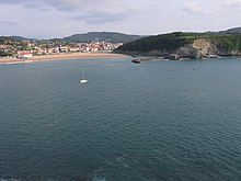
175:The Butroe river joins the sea in Plentzia
65:"Physical geography of the Basque Country"
353:extending all over the north of Navarre,
198:), and in the others, maritime branches (
116:Learn how and when to remove this message
130:physical geography of the Basque Country
183:(known also as the Ría de Bilbao) and
7:
50:adding citations to reliable sources
326:including the Biduze, Errobi, and
14:
244:The most important rock there is
22:
1:
270:is the middle east limit of
233:The Aliutz mountain (Biscay)
221:join the ocean in Lapurdi.
510:
349:Otherwise, from Sakana to
396:The natural park of Barde
406:Geographical landscapes
234:
176:
144:
368:In Biscay, there are
346:and Spanish Navarre.
308:the Mediterranean sea
232:
174:
142:
382:Urkiola Natural Park
272:Cantabrian Mountains
163:peak (2438 m high).
161:Hiru Erregeen Mahaia
46:improve this article
489:Geography of Europe
469:Geography of Europe
235:
177:
145:
464:Iberian peninsula
370:evergreen forests
355:deciduous forests
126:
125:
118:
100:
501:
432:Urdaibai estuary
121:
114:
110:
107:
101:
99:
58:
26:
18:
509:
508:
504:
503:
502:
500:
499:
498:
479:
478:
460:
408:
398:is the biggest
393:
365:and in Aralar.
336:
300:
252:is composed of
227:
169:
151:(south-east of
122:
111:
105:
102:
59:
57:
43:
27:
12:
11:
5:
507:
505:
497:
496:
491:
481:
480:
477:
476:
474:Sierra Salvada
471:
466:
459:
456:
455:
454:
449:
444:
439:
434:
429:
424:
419:
414:
407:
404:
392:
389:
335:
332:
299:
296:
226:
223:
168:
165:
153:Cantabrian Sea
134:Basque Country
124:
123:
30:
28:
21:
13:
10:
9:
6:
4:
3:
2:
506:
495:
492:
490:
487:
486:
484:
475:
472:
470:
467:
465:
462:
461:
457:
453:
450:
448:
445:
443:
440:
438:
435:
433:
430:
428:
425:
423:
420:
418:
415:
413:
410:
409:
405:
403:
401:
397:
390:
388:
385:
383:
379:
375:
371:
366:
364:
360:
356:
352:
347:
345:
341:
340:Lower Navarre
333:
331:
329:
323:
321:
317:
313:
309:
305:
297:
295:
293:
290:, Ordunte or
289:
285:
281:
277:
273:
269:
265:
262:The south of
260:
257:
255:
251:
247:
242:
240:
231:
224:
222:
220:
216:
212:
209:The coast of
207:
205:
201:
197:
193:
188:
186:
182:
173:
166:
164:
162:
158:
154:
150:
149:Bay of Biscay
141:
137:
135:
131:
120:
117:
109:
98:
95:
91:
88:
84:
81:
77:
74:
70:
67: –
66:
62:
61:Find sources:
55:
51:
47:
41:
40:
36:
31:This article
29:
25:
20:
19:
16:
427:Irati Forest
412:Gaztelugatxe
394:
386:
367:
348:
337:
324:
301:
261:
258:
250:Aiako Harria
243:
236:
208:
189:
178:
146:
129:
127:
112:
103:
93:
86:
79:
72:
60:
44:Please help
32:
15:
442:Santimamiñe
483:Categories
437:Oma forest
374:Enkarterri
76:newspapers
314:, Baias,
246:limestone
225:Mountains
181:Ibaizabal
106:July 2011
33:does not
458:See also
422:Donostia
292:Aizkorri
239:Pyrenees
185:Urdaibai
452:Goierri
378:Durango
376:and in
359:Zuberoa
344:Zuberoa
334:Forests
312:Zadorra
268:Navarre
254:granite
215:Bidasoa
211:Lapurdi
204:Bidasoa
90:scholar
54:removed
39:sources
447:Iruñea
417:Bilbao
400:desert
391:Desert
351:Aezkoa
320:Aragon
298:Rivers
288:Anboto
284:Aralar
276:Urbasa
200:Urumea
192:Zumaia
92:
85:
78:
71:
63:
363:Urola
280:Andia
264:Álava
219:Adour
167:Coast
97:JSTOR
83:books
328:Aran
318:and
304:Ebro
302:The
266:and
217:and
196:Oria
157:Ebro
128:The
69:news
37:any
35:cite
316:Ega
206:).
48:by
485::
342:,
294:.
286:,
282:,
278:,
256:.
241:.
202:,
187:.
380:(
119:)
113:(
108:)
104:(
94:·
87:·
80:·
73:·
56:.
42:.
Text is available under the Creative Commons Attribution-ShareAlike License. Additional terms may apply.