268:
61:
232:
48:
256:
244:
68:
176:
community groups rehabilitated the area and rallied decades for its protection. An agreement was made with the
Wildcat Hill Wastewater Treatment Plant, located immediately south of the preserve, to provide a constant water source for the riparian habitat and wildlife. Reclaimed water is discharged into a pond which feeds the
175:
Picture Canyon was listed on the
National Register of Historic Places on January 10, 2008. The 478-acre preserve was purchased October 30, 2012 at a public auction on the steps of Coconino County Courthouse from the State Land Department by the City of Flagstaff for $ 4.8 million after several
203:
is a 2.8-mile outer loop within the preserve. An outdoor classroom with educational panels is located near the start of the trail. The southeast section of the trail initially runs parallel with the Rio De Flag and along the canyon walls where a visitor can view the waterfall within the
356:
210:
is a 0.7-mile section connecting with the Tom Moody Trail to create a smaller loop and brings a visitor to the opposite side of the canyon walls for another view of the waterfall.
97:
371:
180:
through a rugged geological canyon composed of basalt rock. Thousands of years ago, between 700 and 1300 AD, this area was home to the natives known as the
Northern
188:
created by the
Sinagua located along the river. Hundreds of panels were created depicting archers, geometric shapes, and local animals like birds and turtles.
60:
376:
381:
267:
296:
34:
351:
255:
167:. The preserve is used for educating the community about ecology, geology and archaeology along with general outdoor recreation.
204:
preserve. Continuing northeast, after crossing the Rio De Flag Bridge, will bring a visitor to a waterbird petroglyph site.
231:
243:
216:
is a 1.5-mile section of the larger 800+ mile trail that spans from Mexico to Utah, and bisects the Tom Moody Trail.
341:
301:
163:
is an archaeological site and a nature preserve open to the public year-round, located in northeast
47:
164:
85:
143:
365:
316:"Picture Canyon Natural and Cultural Preserve | City of Flagstaff Official Website"
315:
177:
346:
185:
112:
99:
184:(people without water). Picture Canyon is named for the large density of
181:
67:
291:
357:
TripAdvisor-Picture Canyon
Natural & Cultural Preserve
342:
226:
Picture Canyon, National
Register of Historic Places
149:
136:
128:
91:
80:
8:
196:There are three trails within the preserve:
161:Picture Canyon Natural and Cultural Preserve
46:
372:Tourist attractions in Flagstaff, Arizona
35:U.S. National Register of Historic Places
352:AZCentral-Hike Picture Canyon, Flagstaff
283:
224:
347:Hike Arizona-Picture Canyon, Flagstaff
292:"National Register Information System"
18:
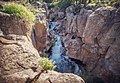
261:Waterfall - view from Tom Moody Trail
7:
297:National Register of Historic Places
14:
377:Parks in Coconino County, Arizona
273:Meadow at the Rio De Flag bridge.
27:Picture Canyon Archeological Site
266:
254:
242:
230:
66:
59:
382:2012 establishments in Arizona
138:
1:
16:United States historic place
192:Trails and Natural Features
398:
137:NRHP reference
54:
45:
41:
32:
25:
21:
84:El Paso Flagstaff Road,
113:35.22903°N 111.55347°W
302:National Park Service
132:30 acres (12 ha)
320:www.flagstaff.az.gov
118:35.22903; -111.55347
304:. November 2, 2013.
109: /
165:Flagstaff, Arizona
86:Flagstaff, Arizona
157:
156:
389:
330:
329:
327:
326:
312:
306:
305:
288:
270:
258:
249:Don Weaver Trail
246:
234:
208:Don Weaver Trail
153:January 10, 2008
140:
124:
123:
121:
120:
119:
114:
110:
107:
106:
105:
102:
70:
69:
63:
50:
19:
397:
396:
392:
391:
390:
388:
387:
386:
362:
361:
338:
333:
324:
322:
314:
313:
309:
290:
289:
285:
281:
274:
271:
262:
259:
250:
247:
238:
237:Tom Moody Trail
235:
223:
201:Tom Moody Trail
117:
115:
111:
108:
103:
100:
98:
96:
95:
76:
75:
74:
73:
72:
71:
37:
28:
17:
12:
11:
5:
395:
393:
385:
384:
379:
374:
364:
363:
360:
359:
354:
349:
344:
337:
336:External links
334:
332:
331:
307:
282:
280:
277:
276:
275:
272:
265:
263:
260:
253:
251:
248:
241:
239:
236:
229:
227:
222:
219:
218:
217:
211:
205:
155:
154:
151:
147:
146:
141:
134:
133:
130:
126:
125:
93:
89:
88:
82:
78:
77:
65:
64:
58:
57:
56:
55:
52:
51:
43:
42:
39:
38:
33:
30:
29:
26:
23:
22:
15:
13:
10:
9:
6:
4:
3:
2:
394:
383:
380:
378:
375:
373:
370:
369:
367:
358:
355:
353:
350:
348:
345:
343:
340:
339:
335:
321:
317:
311:
308:
303:
299:
298:
293:
287:
284:
278:
269:
264:
257:
252:
245:
240:
233:
228:
225:
220:
215:
214:Arizona Trail
212:
209:
206:
202:
199:
198:
197:
194:
193:
189:
187:
183:
179:
173:
172:
168:
166:
162:
152:
150:Added to NRHP
148:
145:
142:
135:
131:
127:
122:
94:
90:
87:
83:
79:
62:
53:
49:
44:
40:
36:
31:
24:
20:
323:. Retrieved
319:
310:
295:
286:
213:
207:
200:
195:
191:
190:
174:
170:
169:
160:
158:
186:petroglyphs
178:Rio de Flag
116: /
104:111°33′12″W
92:Coordinates
366:Categories
325:2018-09-03
279:References
101:35°13′45″N
144:07001349
81:Location
221:Gallery
182:Sinagua
171:History
159:The
129:Area
139:No.
368::
318:.
300:.
294:.
328:.
Text is available under the Creative Commons Attribution-ShareAlike License. Additional terms may apply.