313:
305:, visited the Leroux Springs on September 12, 1857. He described the spring and the start of the river as such: "Leroux's spring is one of transparent sparkling water, and bursts out of the side of the mountain and runs gurgling down for a quarter of a mile, where it loses itself in the valley. To reach it we found it necessary to turn from the course we were steering, and go up into a little mountain glen from which it flows into the valley." Other springs of the river include Antelope/Old Town Spring, by the base of Mars Hill, and San Francisco Spring by the
392:
982:
29:
375:
958:
361:, while the average flow between 2004 and 2013 was 13.5 gallons per minute. During the 20th century, the springs had been modified and sequestered to provide water for the city and for different private owners, with underground pipes particularly reducing the flow. With less need for water from the springs in the 21st century, a project to restore natural flow took place in 2013.
970:
451:. The river did not always run its current course through the city, as during the 20th century it was rerouted in certain areas to allow urban expansion and as a means of flood control. In 2020, $ 52 million was awarded to Flagstaff to finish the Rio de Flag Flood Control Project, with Arizona Senator
352:
owes its existence to Leroux and this expedition; Beale was an admirer of Leroux and made sure his paths traveled by the springs, and in turn it was from Beale's wagon road that the city developed. In 1882, Thomas S. Sedgewick of the railroad company planned to construct a water pipeline to connect
483:
of the river absorbs moisture, allowing a slow release into the river of naturally filtered water, but fires in the area can damage this soil. Within the urban areas, non-absorbent surfaces mean that unfiltered rainwater is entering the river, which can contain pollutants poisonous to fish.
312:
424:, where there is a waterfall between narrow canyon walls. Beyond this, the river crosses Townsend-Winona Road but then follows the road's loop until Logan's Crossing, a wetland and bird sanctuary. After Logan's Crossing, the river turns east-northeast towards the San Francisco Wash and
475:, which has many vertical cracks through which water can travel down to the clay sandstone below; where there is stronger flow the water could cut through this rock, but the river is typically small enough that most spring water is absorbed by the
412:. As the river starts to turn southeast with the highway, Schultz Creek drains into it. The river continues south through downtown Flagstaff, with the Frances Short Pond having formed by Thorpe Park in the west of the city. Here the river crosses
420:(I-40) at Willow Bend, where the I-40 Wetlands are located. The river then turns northeast towards East Flagstaff and passes through Foxglenn Park before crossing back over I-40 and Route 66 and falling into
293:
of the river are the Leroux
Springs, located 1 mile (1.6 km) up Snowbowl Road just northwest of the city, with Taylor Spring and Chimney Spring also sourcing it, and most of the south face
1866:
1014:
1861:
289:
originate the river; they would not produce enough water to maintain flow if not for the heavy rain and snowfall of the area supplementing the levels in the channel. The main
428:. The river from Picture Canyon and Logan's Crossing is mostly fed by water from a nearby wastewater treatment plant. At the east of the city lies the 'Bottomless Pit';
421:
381:
249:
1856:
1007:
744:
336:
on
December 17, 1853 during a later expedition with him. During the Sitgreaves Expedition multiple new species were discovered at the spring, including
584:
1000:
1408:
1098:
1093:
722:
543:
562:
Report of
Explorations for a Railway Route, Near the Thirty-fifth Parallel of Latitude, for the Mississippi River to the Pacific Ocean
1464:
941:
585:"New Publication explores the origin and geology of the Rio de Flag of Flagstaff, Arizona | e-Magazine of the AZ Geological Survey"
909:
1517:
155:
408:
towards the city of
Flagstaff. Its Cheshire Wetlands area begins downstream before the city proper, at Cheshire Park near the
440:
2,000 feet (610 m) deep beneath, the water eventually draining down underground while the pit appears to be bottomless.
432:
created pits where small lakes of the river formed, and when it rains heavily the river begins to fill in a pit that lies on
1239:
324:
The Leroux
Springs are two separate sources: Big Leroux Spring and Little Leroux Spring. The Leroux Springs are named for
306:
948:
429:
1846:
1542:
1436:
76:
690:
1851:
1744:
1721:
1706:
1673:
860:
464:
409:
1701:
1668:
1507:
1375:
1370:
1267:
1156:
1151:
1023:
787:
1595:
1451:
1385:
1181:
417:
413:
1777:
1759:
1532:
1527:
1113:
298:
1605:
1575:
1557:
1494:
1418:
1342:
1302:
1272:
1262:
1136:
1035:
448:
391:
137:
835:
1688:
1610:
1590:
1565:
1403:
1393:
1360:
1327:
1214:
1083:
1053:
1048:
425:
341:
329:
274:
763:
353:
Big Leroux Spring to
Flagstaff, following the course of the river, but the pipeline was not built. The
302:
811:
28:
1797:
1620:
1479:
1398:
1317:
1254:
1146:
1058:
644:
1512:
1355:
345:
337:
333:
317:
286:
270:
58:
1815:
1663:
1580:
1204:
358:
354:
349:
266:
277:. The river's age is unknown, though its first channels were around over one million years ago.
261:, which has historically been known as the River de Flag and San Francisco river, is a river in
1277:
539:
670:"The report of the superintendent of the wagon road from Fort Defiance to the Colorado river"
1782:
1734:
1729:
1638:
1474:
1282:
1219:
1166:
1121:
974:
560:
433:
1767:
1537:
1502:
1459:
1171:
1073:
374:
1585:
1078:
1805:
1570:
1522:
1431:
1350:
1189:
1043:
962:
530:
480:
452:
405:
325:
885:
1840:
1749:
1739:
1658:
1653:
1648:
1643:
1628:
1332:
1297:
1234:
1141:
1131:
986:
416:
and starts to turn east again, Sinclair Wash drains into it; the river then crosses
1820:
1772:
1711:
1678:
1633:
1600:
1547:
1312:
1287:
1199:
1194:
1161:
1088:
1063:
669:
468:
1787:
1484:
1322:
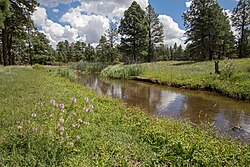
1244:
1224:
1209:
1068:
992:
122:
615:
516:
See document "FOR Rio de Flag Main Stem
Channel Length Data – by Collis Lovely"
501:
1825:
1810:
1696:
1469:
1441:
1426:
1365:
1307:
1292:
1126:
1103:
476:
444:
332:
who led them to the spring in 1851; the bigger spring was given this name by
170:
157:
91:
78:
723:"Leroux Redux: Release of Flow at Big Leroux Spring near Flagstaff, Arizona"
290:
746:
Historic Fort Valley, Arizona An
Archeological Survey and Historic Overview
437:
294:
1027:
910:"Sinema Tours Rio de Flag Flood Control Project with Flagstaff Leaders"
752:. US Department of the Interior, National Park Service. pp. 30–35.
262:
141:
62:
936:
472:
311:
996:
861:"Bottomless Pit in the Kaibab Limestone, Flagstaff (ca. 1915)"
479:. Other surfaces also affect the river. The soil of the
730:
Biennial
Conference of Research on the Colorado Plateau
721:
Monroe, Stephen; Grahame, John; Clark, Shannon (2013).
946:
443:
Before meeting the Little
Colorado, the river has a
1796:
1758:
1720:
1687:
1619:
1556:
1493:
1450:
1417:
1384:
1341:
1253:
1180:
1112:
1034:
320:
as seen from a stream by the Leroux Springs c. 1855
245:
237:
227:
217:
209:
204:
196:
186:
147:
131:
121:
107:
68:
52:
44:
35:
21:
1867:Tributaries of the Lower Colorado River in Arizona
357:of Big Leroux Spring was measured in 1949 at 29
404:From the mountains, the river roughly follows
1008:
8:
1862:Tributaries of the Colorado River in Arizona
1015:
1001:
993:
836:"Arizona geological wonder is seen by few"
953:
493:
18:
716:
714:
712:
710:
639:
637:
635:
610:
608:
606:
604:
579:
577:
575:
524:
522:
7:
942:USGS/AZGS 2019 report on Rio de Flag
241:Frances Short Pond, Logan's Crossing
1857:Rivers of Coconino County, Arizona
14:
668:Beale, Edward F. (May 12, 1858).
980:
968:
956:
529:Olberding, Susan Deaver (2002).
390:
373:
27:
16:River in Arizona, United States
538:. Fort Valley Pub. p. 6.
149: • coordinates
70: • coordinates
1:
348:. It has been suggested that
301:and his men, in planning for
36:Physical characteristics
886:"Rio de Flag: Flood Control"
397:The 'Bottomless Pit' c. 1915
188: • elevation
109: • elevation
677:US House of Representatives
133: • location
54: • location
1883:
937:Friends of The Rio de Flag
816:Friends of the Rio de Flag
792:Friends of the Rio de Flag
768:Friends of the Rio de Flag
695:Friends of the Rio de Flag
649:Friends of the Rio de Flag
506:Friends of the Rio de Flag
410:Museum of Northern Arizona
743:Coody, Robert A. (1988).
273:before draining into the
192:7,000 feet (2,100 m)
117:
113:8,000 feet (2,400 m)
40:
26:
1596:Little Lithodendron Wash
532:Fort Valley Then and Now
297:filling the river, too.
229: • right
559:Whipple, A. W. (1855).
299:Edward Fitzgerald Beale
269:, originating from the
219: • left
914:Senator Kyrsten Sinema
455:visiting the project.
321:
171:35.23667°N 111.17861°W
92:35.29333°N 111.72500°W
1591:Little Colorado River
1215:Little Colorado River
1084:Little Colorado River
589:blog.azgs.arizona.edu
430:volcanism in the area
426:Little Colorado River
342:Western Pocket Gopher
330:Sitgreaves Expedition
315:
275:Little Colorado River
200:33 miles (53 km)
1147:San Bernardino River
691:"Springs of the Rio"
285:Four springs in the
176:35.23667; -111.17861
97:35.29333; -111.72500
1513:Bill Williams River
1409:San Francisco River
1094:San Francisco River
616:"Rio de Flag: Flow"
467:of the river is an
334:Amiel Weeks Whipple
328:, the guide of the
318:San Francisco Peaks
287:San Francisco Peaks
271:San Francisco Peaks
205:Basin features
167: /
88: /
59:San Francisco Peaks
1847:Flagstaff, Arizona
1816:San Cristobal Wash
1664:San Cristobal Wash
1205:Hockey Puck Spring
1024:Rivers and streams
812:"Logan's Crossing"
764:"Cheshire Wetland"
463:Geologically, the
359:gallons per minute
322:
307:McMillan homestead
265:that runs through
127:San Francisco Wash
1852:Rivers of Arizona
1834:
1833:
1722:Santa Cruz County
1543:Santa Maria River
1437:Santa Maria River
1278:Christopher Creek
255:
254:
1874:
1783:Hassayampa River
1745:Santa Cruz River
1730:Babocomari River
1707:Santa Cruz River
1674:Santa Cruz River
1475:Hassayampa River
1283:East Verde River
1167:Tres Alamos Wash
1122:Babocomari River
1017:
1010:
1003:
994:
985:
984:
983:
973:
972:
971:
961:
960:
959:
952:
924:
923:
921:
920:
906:
900:
899:
897:
896:
882:
876:
875:
873:
872:
857:
851:
850:
848:
847:
832:
826:
825:
823:
822:
808:
802:
801:
799:
798:
788:"Picture Canyon"
784:
778:
777:
775:
774:
760:
754:
753:
751:
740:
734:
733:
727:
718:
705:
704:
702:
701:
687:
681:
680:
674:
665:
659:
658:
656:
655:
645:"Map of the Rio"
641:
630:
629:
627:
626:
612:
599:
598:
596:
595:
581:
570:
569:
567:
556:
550:
549:
545:978-09720048-0-0
537:
526:
517:
515:
513:
512:
498:
434:Kaibab Limestone
394:
377:
346:Woodhouse's toad
338:Abert's squirrel
230:
220:
182:
181:
179:
178:
177:
172:
168:
165:
164:
163:
160:
110:
103:
102:
100:
99:
98:
93:
89:
86:
85:
84:
81:
71:
55:
31:
19:
1882:
1881:
1877:
1876:
1875:
1873:
1872:
1871:
1837:
1836:
1835:
1830:
1792:
1768:Agua Fria River
1754:
1716:
1702:San Pedro River
1683:
1669:San Pedro River
1615:
1552:
1538:Sacramento Wash
1518:Centennial Wash
1508:Big Sandy River
1503:Beaver Dam Wash
1489:
1465:Centennial Wash
1460:Agua Fria River
1452:Maricopa County
1446:
1413:
1386:Greenlee County
1380:
1376:San Simon River
1371:San Pedro River
1337:
1249:
1182:Coconino County
1176:
1172:Whitewater Draw
1157:San Simon River
1152:San Pedro River
1108:
1074:Kinlichee Creek
1030:
1021:
991:
981:
979:
969:
967:
957:
955:
947:
933:
928:
927:
918:
916:
908:
907:
903:
894:
892:
884:
883:
879:
870:
868:
859:
858:
854:
845:
843:
834:
833:
829:
820:
818:
810:
809:
805:
796:
794:
786:
785:
781:
772:
770:
762:
761:
757:
749:
742:
741:
737:
725:
720:
719:
708:
699:
697:
689:
688:
684:
672:
667:
666:
662:
653:
651:
643:
642:
633:
624:
622:
614:
613:
602:
593:
591:
583:
582:
573:
565:
558:
557:
553:
546:
535:
528:
527:
520:
510:
508:
500:
499:
495:
490:
461:
402:
401:
400:
399:
398:
395:
386:
385:
384:
378:
367:
283:
228:
218:
189:
175:
173:
169:
166:
161:
158:
156:
154:
153:
150:
134:
108:
96:
94:
90:
87:
82:
79:
77:
75:
74:
69:
53:
17:
12:
11:
5:
1880:
1878:
1870:
1869:
1864:
1859:
1854:
1849:
1839:
1838:
1832:
1831:
1829:
1828:
1823:
1818:
1813:
1808:
1806:Colorado River
1802:
1800:
1794:
1793:
1791:
1790:
1785:
1780:
1775:
1770:
1764:
1762:
1760:Yavapai County
1756:
1755:
1753:
1752:
1747:
1742:
1737:
1732:
1726:
1724:
1718:
1717:
1715:
1714:
1709:
1704:
1699:
1693:
1691:
1685:
1684:
1682:
1681:
1676:
1671:
1666:
1661:
1656:
1651:
1646:
1641:
1636:
1631:
1625:
1623:
1617:
1616:
1614:
1613:
1608:
1603:
1598:
1593:
1588:
1583:
1578:
1573:
1571:Chevelon Creek
1568:
1562:
1560:
1554:
1553:
1551:
1550:
1545:
1540:
1535:
1530:
1525:
1523:Colorado River
1520:
1515:
1510:
1505:
1499:
1497:
1491:
1490:
1488:
1487:
1482:
1477:
1472:
1467:
1462:
1456:
1454:
1448:
1447:
1445:
1444:
1439:
1434:
1432:Colorado River
1429:
1423:
1421:
1415:
1414:
1412:
1411:
1406:
1401:
1396:
1390:
1388:
1382:
1381:
1379:
1378:
1373:
1368:
1363:
1358:
1353:
1351:Aravaipa Creek
1347:
1345:
1339:
1338:
1336:
1335:
1330:
1325:
1320:
1315:
1310:
1305:
1300:
1295:
1290:
1285:
1280:
1275:
1270:
1265:
1259:
1257:
1251:
1250:
1248:
1247:
1242:
1237:
1232:
1227:
1222:
1217:
1212:
1207:
1202:
1197:
1192:
1190:Colorado River
1186:
1184:
1178:
1177:
1175:
1174:
1169:
1164:
1159:
1154:
1149:
1144:
1139:
1134:
1129:
1124:
1118:
1116:
1114:Cochise County
1110:
1109:
1107:
1106:
1101:
1096:
1091:
1086:
1081:
1076:
1071:
1066:
1061:
1056:
1051:
1046:
1044:Agua Sal Creek
1040:
1038:
1032:
1031:
1022:
1020:
1019:
1012:
1005:
997:
990:
989:
977:
965:
945:
944:
939:
932:
931:External links
929:
926:
925:
901:
877:
852:
827:
803:
779:
755:
735:
706:
682:
660:
631:
600:
571:
551:
544:
518:
492:
491:
489:
486:
481:drainage basin
460:
457:
453:Kyrsten Sinema
422:Picture Canyon
396:
389:
388:
387:
382:Picture Canyon
379:
372:
371:
370:
369:
368:
366:
363:
326:Antoine Leroux
303:his wagon road
282:
279:
253:
252:
250:Picture Canyon
247:
243:
242:
239:
235:
234:
231:
225:
224:
221:
215:
214:
211:
207:
206:
202:
201:
198:
194:
193:
190:
187:
184:
183:
151:
148:
145:
144:
135:
132:
129:
128:
125:
119:
118:
115:
114:
111:
105:
104:
72:
66:
65:
56:
50:
49:
48:Leroux Springs
46:
42:
41:
38:
37:
33:
32:
24:
23:
15:
13:
10:
9:
6:
4:
3:
2:
1879:
1868:
1865:
1863:
1860:
1858:
1855:
1853:
1850:
1848:
1845:
1844:
1842:
1827:
1824:
1822:
1819:
1817:
1814:
1812:
1809:
1807:
1804:
1803:
1801:
1799:
1795:
1789:
1786:
1784:
1781:
1779:
1778:Granite Creek
1776:
1774:
1771:
1769:
1766:
1765:
1763:
1761:
1757:
1751:
1750:Sonoita Creek
1748:
1746:
1743:
1741:
1740:Harshaw Creek
1738:
1736:
1735:Ciénega Creek
1733:
1731:
1728:
1727:
1725:
1723:
1719:
1713:
1710:
1708:
1705:
1703:
1700:
1698:
1695:
1694:
1692:
1690:
1686:
1680:
1677:
1675:
1672:
1670:
1667:
1665:
1662:
1660:
1657:
1655:
1654:Rillito River
1652:
1650:
1647:
1645:
1644:Mescal Arroyo
1642:
1640:
1639:Ciénega Creek
1637:
1635:
1632:
1630:
1629:Arivaca Creek
1627:
1626:
1624:
1622:
1618:
1612:
1609:
1607:
1604:
1602:
1599:
1597:
1594:
1592:
1589:
1587:
1584:
1582:
1579:
1577:
1576:Cibecue Creek
1574:
1572:
1569:
1567:
1564:
1563:
1561:
1559:
1558:Navajo County
1555:
1549:
1546:
1544:
1541:
1539:
1536:
1534:
1531:
1529:
1528:Diamond Creek
1526:
1524:
1521:
1519:
1516:
1514:
1511:
1509:
1506:
1504:
1501:
1500:
1498:
1496:
1495:Mohave County
1492:
1486:
1483:
1481:
1478:
1476:
1473:
1471:
1468:
1466:
1463:
1461:
1458:
1457:
1455:
1453:
1449:
1443:
1440:
1438:
1435:
1433:
1430:
1428:
1425:
1424:
1422:
1420:
1419:La Paz County
1416:
1410:
1407:
1405:
1402:
1400:
1397:
1395:
1392:
1391:
1389:
1387:
1383:
1377:
1374:
1372:
1369:
1367:
1364:
1362:
1359:
1357:
1354:
1352:
1349:
1348:
1346:
1344:
1343:Graham County
1340:
1334:
1333:Workman Creek
1331:
1329:
1326:
1324:
1321:
1319:
1316:
1314:
1311:
1309:
1306:
1304:
1301:
1299:
1298:Haigler Creek
1296:
1294:
1291:
1289:
1286:
1284:
1281:
1279:
1276:
1274:
1271:
1269:
1266:
1264:
1261:
1260:
1258:
1256:
1252:
1246:
1243:
1241:
1240:Thunder River
1238:
1236:
1235:Tapeats Creek
1233:
1231:
1228:
1226:
1223:
1221:
1218:
1216:
1213:
1211:
1208:
1206:
1203:
1201:
1198:
1196:
1193:
1191:
1188:
1187:
1185:
1183:
1179:
1173:
1170:
1168:
1165:
1163:
1160:
1158:
1155:
1153:
1150:
1148:
1145:
1143:
1142:Mescal Arroyo
1140:
1138:
1135:
1133:
1130:
1128:
1125:
1123:
1120:
1119:
1117:
1115:
1111:
1105:
1102:
1100:
1097:
1095:
1092:
1090:
1087:
1085:
1082:
1080:
1077:
1075:
1072:
1070:
1067:
1065:
1062:
1060:
1057:
1055:
1052:
1050:
1047:
1045:
1042:
1041:
1039:
1037:
1036:Apache County
1033:
1029:
1025:
1018:
1013:
1011:
1006:
1004:
999:
998:
995:
988:
978:
976:
966:
964:
954:
950:
943:
940:
938:
935:
934:
930:
915:
911:
905:
902:
891:
887:
881:
878:
866:
862:
856:
853:
841:
837:
831:
828:
817:
813:
807:
804:
793:
789:
783:
780:
769:
765:
759:
756:
748:
747:
739:
736:
731:
724:
717:
715:
713:
711:
707:
696:
692:
686:
683:
678:
671:
664:
661:
650:
646:
640:
638:
636:
632:
621:
617:
611:
609:
607:
605:
601:
590:
586:
580:
578:
576:
572:
568:. p. 23.
564:
563:
555:
552:
547:
541:
534:
533:
525:
523:
519:
507:
503:
497:
494:
487:
485:
482:
478:
474:
470:
466:
458:
456:
454:
450:
446:
441:
439:
435:
431:
427:
423:
419:
418:Interstate 40
415:
411:
407:
393:
383:
380:Waterfall at
376:
364:
362:
360:
356:
351:
347:
343:
339:
335:
331:
327:
319:
314:
310:
308:
304:
300:
296:
292:
288:
280:
278:
276:
272:
268:
264:
260:
251:
248:
244:
240:
236:
233:Sinclair Wash
232:
226:
223:Schultz Creek
222:
216:
212:
208:
203:
199:
195:
191:
185:
180:
152:
146:
143:
139:
136:
130:
126:
124:
120:
116:
112:
106:
101:
73:
67:
64:
60:
57:
51:
47:
43:
39:
34:
30:
25:
20:
1821:Tenmile Wash
1773:Fossil Creek
1712:Tom Mix Wash
1689:Pinal County
1679:Tenmile Wash
1659:Sabino Creek
1649:Molino Creek
1634:Brawley Wash
1606:Silver Creek
1601:Puerco River
1586:Laguña Creek
1548:Virgin River
1533:Kingman Wash
1313:Salome Creek
1303:Horton Creek
1288:Fossil Creek
1273:Cherry Creek
1268:Canyon Creek
1263:Canyon Creek
1229:
1200:Havasu Creek
1195:Fossil Creek
1162:Steins Creek
1137:Dragoon Wash
1132:Bonita Creek
1099:Walker Creek
1089:Puerco River
1079:Laguña Creek
1064:Chinle Creek
917:. Retrieved
913:
904:
893:. Retrieved
890:www2.nau.edu
889:
880:
869:. Retrieved
867:. 2018-09-17
864:
855:
844:. Retrieved
842:. 2013-07-15
839:
830:
819:. Retrieved
815:
806:
795:. Retrieved
791:
782:
771:. Retrieved
767:
758:
745:
738:
729:
698:. Retrieved
694:
685:
676:
663:
652:. Retrieved
648:
623:. Retrieved
620:www2.nau.edu
619:
592:. Retrieved
588:
561:
554:
531:
509:. Retrieved
505:
496:
469:igneous rock
462:
449:Walnut Creek
442:
403:
323:
284:
258:
256:
138:Walnut Creek
1798:Yuma County
1788:Verde River
1621:Pima County
1611:White River
1581:Clear Creek
1566:Black River
1485:Verde River
1404:Eagle Creek
1394:Black River
1361:Black River
1328:White River
1323:Tonto Creek
1255:Gila County
1245:Verde River
1230:Rio de Flag
1225:Paria River
1210:Kanab Creek
1069:Chinle Wash
1054:Black River
1049:Black Creek
502:"Resources"
365:River route
259:Rio de Flag
238:Waterbodies
210:Tributaries
174: /
162:111°10′43″W
95: /
83:111°43′30″W
22:Rio de Flag
1841:Categories
1826:Tyson Wash
1811:Gila River
1697:Gila River
1480:Salt River
1470:Gila River
1442:Tyson Wash
1427:Bouse Wash
1399:Blue River
1366:Gila River
1318:Salt River
1308:Negro Wash
1293:Gila River
1127:Black Draw
1104:Zuni River
1059:Blue River
919:2020-04-07
895:2020-04-07
871:2020-04-07
846:2020-04-07
821:2020-04-07
797:2020-04-07
773:2020-04-07
700:2020-04-07
654:2020-04-07
625:2020-04-07
594:2020-04-07
511:2020-04-13
488:References
477:stream bed
445:confluence
291:headwaters
281:Headwaters
246:Waterfalls
159:35°14′12″N
80:35°17′36″N
1356:Ash Creek
1220:Oak Creek
975:Geography
465:substrate
406:Route 180
350:Flagstaff
267:Flagstaff
840:KTAR.com
438:sinkhole
414:Route 66
295:snowmelt
1028:Arizona
963:Arizona
949:Portals
471:called
459:Geology
436:with a
263:Arizona
142:Arizona
63:Arizona
987:Rivers
542:
473:basalt
344:, and
340:, the
213:
197:Length
45:Source
750:(PDF)
726:(PDF)
679:: 51.
673:(PDF)
566:(PDF)
536:(PDF)
447:with
123:Mouth
865:AZGS
540:ISBN
355:flow
316:The
257:The
1026:of
1843::
912:.
888:.
863:.
838:.
814:.
790:.
766:.
728:.
709:^
693:.
675:.
647:.
634:^
618:.
603:^
587:.
574:^
521:^
504:.
309:.
140:,
61:,
1016:e
1009:t
1002:v
951::
922:.
898:.
874:.
849:.
824:.
800:.
776:.
732:.
703:.
657:.
628:.
597:.
548:.
514:.
Text is available under the Creative Commons Attribution-ShareAlike License. Additional terms may apply.