54:
38:
558:
61:
213:
391:
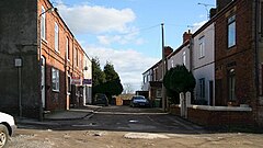
Pilsley consists of two distinct residential areas known as Lower
Pilsley and Pilsley (sometimes Upper Pilsley), Lower Pilsley to the north and Pilsley to the south. There is some local disagreement as to whether these two areas constitute two separate villages or one larger village. At the start of
383:
Before 1800, Pilsley was an agricultural settlement consisting of Upper
Pilsley and Nether Pilsley. Few of the houses from that period still exist: there are some on the corner of Station Road and Sitwell Grange Lane near the Primary School and others around Barlow Bank, Barlow Bank Farm and Grange
392:
the village's life, people referred to the area around what is now
Pilsley primary as Nether Pilsley. Both areas of the village are united by the same parish council, Pilsley Parish Council, which was formed on 30 January 1874, Pilsley having previously been part of the parish of
425:
384:
Farm in Upper
Pilsley near the site of the village well. These houses are made from locally quarried coal-measure sandstone which is soft and contains a high percentage of iron. This quarry no longer exists, but was north of Upper Pilsley.
387:
Pilsley
Colliery was founded in 1866 on the site of the present day Locko Plantation. At its peak the colliery comprised six shafts, employed 945 men and produced 1,200 tons of coal per shift. The colliery was closed in 1957.
342:. Pilsley also has a Village Hall and St Mary's Centre (formerly the church hall). Recently a new sports centre (The Elm Centre) was built for the school which is also available for community use. A section of the
550:
127:
396:. Maps show that the village is made up of four separate residential areas, which are, in order from north to south, Lower Pilsley, Upper Pilsley, Pilsley and Nether Pilsley.
100:
405:
582:
237:
365:
Pilsley has a Sunday league football team called
Pilsley Miners Welfare Football Club. The team is currently part of the Chesterfield and District Sunday League.
279:
587:
562:
358:
was on
Station Road. The route of this former railway line now serves as a popular walking, cycling and horse riding trail known as the
225:
230:
53:
524:
469:
261:
577:
242:
197:
163:
508:
Kelly's
Directory of the Counties of Derby, Notts, Leicester and Rutland, pub. London (May, 1891) - p.284, accessed May 2013
369:
93:
271:
482:
338:
church, St Mary's, an evangelical
Methodist church, two primary schools, a post office and a Kingdom Hall building for
266:
17:
328:
177:
355:
218:
339:
347:
320:
117:
109:
346:(Nottingham to Chesterfield section) runs along the western edge of the village. A branch of the
145:
380:
Pilsley is mentioned in the
Domesday Book as one of the manors belonging to Walter D'Aincourt.
37:
520:
465:
343:
393:
359:
202:
571:
351:
153:
316:
507:
519:
Explorer 269, Chesterfield and Alfreton 1:25000 scale, Ordnance Survey, 1999,
324:
135:
74:
294:
281:
486:
187:
557:
450:
335:
169:
545:
362:, linking Pilsley to Tibshelf, Holmewood, Grassmoor and beyond.
540:
236:
224:
212:
196:
186:
176:
162:
144:
126:
108:
92:
84:
30:
406:Listed buildings in Pilsley, North East Derbyshire
331:. At the 2011 Census the population was 3,487.
8:
451:Pilsley Miners Welfare Football Club Website
27:
541:St Mary's Church and Centre website, 2013
583:Towns and villages of the Peak District
417:
207:
185:
161:
91:
34:
462:Domesday Book: A Complete Translation
235:
223:
211:
195:
175:
143:
125:
107:
7:
551:Pilsley Parish Council webpage, 2013
350:ran through the village before the
14:
556:
432:. Office for National Statistics
59:
52:
36:
464:. London: Penguin, 2003. p.750
60:
588:North East Derbyshire District
563:Pilsley, North East Derbyshire
426:"Civil parish population 2011"
1:
327:, England, near the town of
481:Bridgewater, A. N. (2001).
94:OS grid reference
25:Human settlement in England
604:
15:
252:
248:
208:
47:
35:
18:Pilsley, Derbyshire Dales
546:Pilsley Bowls Club, 2018
430:Neighbourhood Statistics
16:Not to be confused with
356:Pilsley railway station
578:Villages in Derbyshire
198:Postcode district
565:at Wikimedia Commons
348:Great Central Railway
321:North East Derbyshire
118:North East Derbyshire
178:Sovereign state
489:on 21 February 2014
340:Jehovah's Witnesses
319:in the district of
291: /
42:New Street, Pilsley
483:"Pilsley Colliery"
368:The source of the
561:Media related to
344:Midland Main Line
323:in the county of
315:is a village and
310:
309:
128:Shire county
88:3,487 (2011)
595:
560:
528:
516:
510:
505:
499:
498:
496:
494:
485:. Archived from
478:
472:
459:
453:
448:
442:
441:
439:
437:
422:
306:
305:
303:
302:
301:
296:
295:53.155°N 1.366°W
292:
289:
288:
287:
284:
258:
172:
104:
103:
73:Location within
63:
62:
56:
40:
28:
603:
602:
598:
597:
596:
594:
593:
592:
568:
567:
537:
532:
531:
517:
513:
506:
502:
492:
490:
480:
479:
475:
460:
456:
449:
445:
435:
433:
424:
423:
419:
414:
402:
394:North Wingfield
378:
372:is at Pilsley.
360:Five Pits Trail
334:Pilsley has an
299:
297:
293:
290:
285:
282:
280:
278:
277:
276:
256:
168:
158:
140:
122:
99:
98:
80:
79:
78:
77:
71:
70:
69:
68:
64:
43:
26:
21:
12:
11:
5:
601:
599:
591:
590:
585:
580:
570:
569:
554:
553:
548:
543:
536:
535:External links
533:
530:
529:
511:
500:
473:
454:
443:
416:
415:
413:
410:
409:
408:
401:
398:
377:
374:
354:of the 1960s;
308:
307:
300:53.155; -1.366
275:
274:
269:
264:
259:
257:List of places
253:
250:
249:
246:
245:
240:
234:
233:
228:
222:
221:
216:
210:
209:
206:
205:
200:
194:
193:
190:
184:
183:
182:United Kingdom
180:
174:
173:
166:
160:
159:
157:
156:
150:
148:
142:
141:
139:
138:
132:
130:
124:
123:
121:
120:
114:
112:
106:
105:
96:
90:
89:
86:
82:
81:
72:
66:
65:
58:
57:
51:
50:
49:
48:
45:
44:
41:
33:
32:
24:
13:
10:
9:
6:
4:
3:
2:
600:
589:
586:
584:
581:
579:
576:
575:
573:
566:
564:
559:
552:
549:
547:
544:
542:
539:
538:
534:
527:
526:
525:0-319-21905-4
522:
515:
512:
509:
504:
501:
488:
484:
477:
474:
471:
470:0-14-143994-7
467:
463:
458:
455:
452:
447:
444:
431:
427:
421:
418:
411:
407:
404:
403:
399:
397:
395:
389:
385:
381:
375:
373:
371:
366:
363:
361:
357:
353:
352:Beeching cuts
349:
345:
341:
337:
332:
330:
326:
322:
318:
314:
304:
273:
270:
268:
265:
263:
260:
255:
254:
251:
247:
244:
243:East Midlands
241:
239:
232:
229:
227:
220:
217:
215:
204:
201:
199:
191:
189:
181:
179:
171:
167:
165:
155:
154:East Midlands
152:
151:
149:
147:
137:
134:
133:
131:
129:
119:
116:
115:
113:
111:
102:
97:
95:
87:
83:
76:
55:
46:
39:
29:
23:
19:
555:
518:
514:
503:
491:. Retrieved
487:the original
476:
461:
457:
446:
434:. Retrieved
429:
420:
390:
386:
382:
379:
370:River Rother
367:
364:
333:
329:Chesterfield
317:civil parish
312:
311:
192:CHESTERFIELD
22:
298: /
572:Categories
412:References
325:Derbyshire
283:53°09′18″N
272:Derbyshire
231:Derbyshire
219:Derbyshire
136:Derbyshire
85:Population
75:Derbyshire
286:1°21′58″W
238:Ambulance
188:Post town
436:30 March
400:See also
336:Anglican
110:District
101:SK424621
376:History
313:Pilsley
267:England
170:England
164:Country
67:Pilsley
31:Pilsley
523:
493:9 June
468:
214:Police
146:Region
521:ISBN
495:2024
466:ISBN
438:2016
226:Fire
203:S45
574::
428:.
262:UK
497:.
440:.
20:.
Text is available under the Creative Commons Attribution-ShareAlike License. Additional terms may apply.