77:
1369:
515:
107:
137:
53:
531:
840:, there were 143 people, 60 households, and 41 families residing here. The population density was 1,027.6 inhabitants per square mile (396.8/km). There were 70 housing units at an average density of 503.0 per square mile (194.2/km). The racial makeup was 98.6% white, 0.7% black or African American, 0.0% from other races, and 0.7% from two or more races. Those of Hispanic or Latino origin made up 0.7% of the population. In terms of ancestry, 32.8% were
144:
114:
84:
863:
Of the 60 households, 26.7% had children under the age of 18 living with them, 55.0% were married couples living together, 8.3% had a female householder with no husband present, 31.7% were non-families, and 28.3% of all households were made up of individuals. The average household size was 2.38
448:
The town was founded at the location of a trading post called Pine
Village, which may have been named for a lone pine tree that stood on the bluff of Pine Creek, or it may have been named for the creek itself. The town was laid out in 1851 by Isaac and John R. Metsker, and the plat map was made by
867:
The median income for a household was $ 48,750 and the median income for a family was $ 62,083. Males had a median income of $ 58,750 versus $ 36,250 for females. The per capita income for was $ 26,957. About 17.4% of families and 17.2% of the population were below the
492:
on August 5, 1931, and incremental abandonment occurred over subsequent years. The line through Pine
Village was scrapped in the fall of 1945, and the rails were pulled up using a Belgian horse and a
76:
564:
1292:
1712:
1184:
484:
transported along it. When the C&EI floundered in the early 1920s, Charles F. Propst purchased the Coal Road and in
October 1922 incorporated it as the
1443:
169:
1244:
1214:
1154:
1097:
1707:
1433:
1428:
1403:
561:
The area on the east side of Pine
Village near the railroad, consisting of a grain elevator and some homes, was known as Oklahoma and is located at
136:
1717:
1438:
1408:
1393:
395:
52:
1413:
1388:
421:
240:
106:
1423:
1418:
1398:
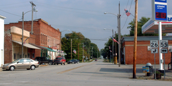
485:
477:
1644:
1609:
1285:
514:
1589:
405:
1037:
889:
505:
1278:
1006:
1270:
1071:
461:
235:
1192:
1248:
1218:
1188:
1158:
1101:
1075:
956:
931:
465:
223:
558:
border. According to the 2010 census, Pine
Village has a total area of 0.12 square miles (0.31 km), all land.
1252:
1222:
1215:"DP02 SELECTED SOCIAL CHARACTERISTICS IN THE UNITED STATES – 2006-2010 American Community Survey 5-Year Estimates"
1162:
1105:
1702:
1614:
837:
815:
800:
785:
770:
755:
740:
725:
710:
695:
680:
665:
650:
635:
437:
1639:
1348:
547:
383:
268:
201:
915:
1624:
1453:
1672:
1629:
1599:
1302:
449:
county surveyor Perrin Kent. The
Methodist Church was already there; it was built several years earlier.
425:
228:
1531:
1476:
1358:
1353:
1324:
543:
539:
363:
62:
58:
1679:
352:
460:
Rail service reached the town in the 1870s. The year 1883 witnessed the completion of a north/south
1594:
1579:
1574:
1564:
1526:
1516:
1501:
1491:
1466:
1649:
1559:
1481:
551:
473:
1127:
1245:"DP03 SELECTED ECONOMIC CHARACTERISTICS – 2006-2010 American Community Survey 5-Year Estimates"
1155:"DP-1 Profile of General Population and Housing Characteristics: 2010 Demographic Profile Data"
530:
1619:
1604:
1541:
1335:
1033:
342:
1584:
1536:
1471:
493:
1569:
1486:
1461:
469:
1634:
1496:
1380:
857:
1696:
388:
1506:
869:
849:
489:
916:
U.S. Geological Survey
Geographic Names Information System: Pine Village, Indiana
1317:
1551:
429:
211:
580:
566:
184:
171:
853:
333:
17:
1056:
Rhode, Robert T. (2002). "A Walk Around Pine
Village in the Early 1920s".
476:, some 50 miles (80 km) to the north. The line was later part of the
1663:‡This populated place also has portions in an adjacent county or counties
872:, including 0.0% of those under age 18 and 0.0% of those age 65 or over.
555:
371:
263:
841:
433:
216:
864:
and the average family size was 2.85. The median age was 46.1 years.
845:
480:. It came to be known as the "Coal Road" for the large quantities of
529:
452:
The post office at Pine
Village has been in operation since 1854.
359:
338:
1368:
953:"Profile of General Population and Housing Characteristics: 2010"
481:
43:
1274:
981:. Bloomington, Indiana: Indiana University Press. p. 130.
1367:
1098:"G001 - Geographic Identifiers - 2010 Census Summary File 1"
952:
927:
504:
During the mid-1910s, Pine
Village hosted a prominent
1185:"Population, Housing Units, Area, and Density: 2010"
995:. Warren County Historical Society. 1966. p. 6.
1658:
1550:
1515:
1452:
1379:
1334:
404:
394:
382:
370:
349:
332:
324:
316:
311:
303:
295:
287:
279:
274:
262:
254:
246:
234:
222:
210:
200:
34:
538:Pine Village is located at the intersection of
1028:Sulzer, Elmer G. (1998). "The Old Coal Road".
1286:
1149:
1147:
1145:
550:. It is about 20 miles (32 km) west of
143:
113:
83:
8:
554:and about 14 miles (23 km) east of the
1293:
1279:
1271:
1072:"US Gazetteer files: 2010, 2000, and 1990"
977:Baker, Ronald L.; Carmony, Marvin (1975).
608:
31:
1372:Map of Indiana highlighting Warren County
57:Lafayette Street at the intersection of
1051:
1049:
881:
510:
393:
369:
331:
310:
302:
273:
245:
199:
164:
68:
49:
911:
909:
907:
628:
486:Chicago, Attica and Southern Railroad
478:Chicago and Eastern Illinois Railroad
403:
381:
348:
323:
315:
294:
286:
278:
261:
253:
233:
221:
209:
7:
1713:Populated places established in 1851
1060:. Warren County Historical Society.
1058:A History of Warren County, Indiana
993:A History of Warren County, Indiana
299:0.00 sq mi (0.00 km)
291:0.12 sq mi (0.31 km)
283:0.12 sq mi (0.31 km)
1301:Municipalities and communities of
1128:"Census of Population and Housing"
618:
462:Chicago and Great Southern Railway
96:Show map of Warren County, Indiana
25:
513:
466:Chicago and Indiana Coal Railway
436:. The population was 217 at the
142:
135:
112:
105:
82:
75:
51:
1708:Towns in Warren County, Indiana
328:1,766.67/sq mi (680.07/km)
1718:1851 establishments in Indiana
29:Town in Indiana, United States
1:
892:. United States Census Bureau
488:. The CA&S was placed in
156:Show map of the United States
1032:. Indiana University Press.
1249:United States Census Bureau
1219:United States Census Bureau
1189:United States Census Bureau
1159:United States Census Bureau
1102:United States Census Bureau
1076:United States Census Bureau
957:United States Census Bureau
932:United States Census Bureau
890:"2020 U.S. Gazetteer Files"
1734:
1030:Ghost Railroads of Indiana
1009:. Jim Forte Postal History
1668:
1365:
1315:
838:2010 United States Census
829:
814:
799:
784:
769:
754:
739:
724:
709:
694:
679:
664:
649:
634:
627:
622:
617:
614:
520:The football team of 1915
165:
69:
50:
41:
307:689 ft (210 m)
1373:
1304:Warren County, Indiana
535:
258:Isaac and John Metsker
1371:
928:"U.S. Census website"
830:U.S. Decennial Census
610:Historical population
581:40.44972°N 87.24500°W
533:
506:professional football
500:Professional football
351: • Summer (
185:40.44944°N 87.25333°W
150:Pine Village, Indiana
120:Pine Village, Indiana
90:Pine Village, Indiana
36:Pine Village, Indiana
1681:United States portal
1255:on February 13, 2020
1225:on February 13, 2020
1195:on February 12, 2020
1165:on February 12, 2020
1108:on February 13, 2020
325: • Density
1078:. February 12, 2011
979:Indiana Place Names
611:
586:40.44972; -87.24500
576: /
534:Map of Pine Village
190:40.44944; -87.25333
181: /
126:Show map of Indiana
1374:
609:
536:
317: • Total
296: • Water
280: • Total
1690:
1689:
834:
833:
415:
414:
288: • Land
16:(Redirected from
1725:
1703:Towns in Indiana
1682:
1675:
1615:Mudlavia Springs
1370:
1327:
1320:
1310:
1305:
1295:
1288:
1281:
1272:
1265:
1264:
1262:
1260:
1251:. Archived from
1241:
1235:
1234:
1232:
1230:
1221:. Archived from
1211:
1205:
1204:
1202:
1200:
1191:. Archived from
1181:
1175:
1174:
1172:
1170:
1161:. Archived from
1151:
1140:
1139:
1137:
1135:
1124:
1118:
1117:
1115:
1113:
1104:. Archived from
1094:
1088:
1087:
1085:
1083:
1068:
1062:
1061:
1053:
1044:
1043:
1025:
1019:
1018:
1016:
1014:
1003:
997:
996:
989:
983:
982:
974:
968:
967:
965:
963:
949:
943:
942:
940:
938:
924:
918:
913:
902:
901:
899:
897:
886:
856:, and 9.8% were
630:
625:
620:
612:
600:
599:
597:
596:
595:
593:
588:
587:
582:
577:
574:
573:
572:
569:
517:
494:block and tackle
356:
196:
195:
193:
192:
191:
186:
182:
179:
178:
177:
174:
157:
146:
145:
139:
127:
116:
115:
109:
97:
86:
85:
79:
55:
32:
21:
1733:
1732:
1728:
1727:
1726:
1724:
1723:
1722:
1693:
1692:
1691:
1686:
1680:
1673:
1664:
1654:
1640:Sycamore Corner
1546:
1518:
1511:
1448:
1375:
1363:
1349:State Line City
1330:
1325:
1318:
1311:
1308:
1303:
1299:
1269:
1268:
1258:
1256:
1243:
1242:
1238:
1228:
1226:
1213:
1212:
1208:
1198:
1196:
1183:
1182:
1178:
1168:
1166:
1153:
1152:
1143:
1133:
1131:
1126:
1125:
1121:
1111:
1109:
1096:
1095:
1091:
1081:
1079:
1070:
1069:
1065:
1055:
1054:
1047:
1040:
1027:
1026:
1022:
1012:
1010:
1007:"Warren County"
1005:
1004:
1000:
991:
990:
986:
976:
975:
971:
961:
959:
951:
950:
946:
936:
934:
926:
925:
921:
914:
905:
895:
893:
888:
887:
883:
878:
623:
607:
591:
589:
585:
583:
579:
578:
575:
570:
567:
565:
563:
562:
528:
521:
518:
502:
468:) line between
458:
446:
378:
350:
189:
187:
183:
180:
175:
172:
170:
168:
167:
161:
160:
159:
158:
155:
154:
153:
152:
151:
147:
130:
129:
128:
125:
124:
123:
122:
121:
117:
100:
99:
98:
95:
94:
93:
92:
91:
87:
65:
46:
37:
30:
23:
22:
15:
12:
11:
5:
1731:
1729:
1721:
1720:
1715:
1710:
1705:
1695:
1694:
1688:
1687:
1685:
1684:
1677:
1674:Indiana portal
1669:
1666:
1665:
1662:
1660:
1656:
1655:
1653:
1652:
1647:
1642:
1637:
1632:
1627:
1625:Point Pleasant
1622:
1617:
1612:
1607:
1602:
1597:
1592:
1587:
1582:
1577:
1572:
1567:
1562:
1556:
1554:
1548:
1547:
1545:
1544:
1539:
1534:
1529:
1523:
1521:
1513:
1512:
1510:
1509:
1504:
1499:
1494:
1489:
1484:
1479:
1474:
1469:
1464:
1458:
1456:
1450:
1449:
1447:
1446:
1441:
1436:
1431:
1426:
1421:
1416:
1411:
1406:
1401:
1396:
1391:
1385:
1383:
1377:
1376:
1366:
1364:
1362:
1361:
1356:
1351:
1346:
1340:
1338:
1332:
1331:
1316:
1313:
1312:
1300:
1298:
1297:
1290:
1283:
1275:
1267:
1266:
1236:
1206:
1176:
1141:
1119:
1089:
1063:
1045:
1038:
1020:
998:
984:
969:
944:
919:
903:
880:
879:
877:
874:
832:
831:
827:
826:
823:
821:
818:
812:
811:
808:
806:
803:
797:
796:
793:
791:
788:
782:
781:
778:
776:
773:
767:
766:
763:
761:
758:
752:
751:
748:
746:
743:
737:
736:
733:
731:
728:
722:
721:
718:
716:
713:
707:
706:
703:
701:
698:
692:
691:
688:
686:
683:
677:
676:
673:
671:
668:
662:
661:
658:
656:
653:
647:
646:
643:
641:
638:
632:
631:
626:
621:
616:
606:
603:
548:Big Pine Creek
527:
524:
523:
522:
519:
512:
501:
498:
457:
454:
445:
442:
422:Adams Township
413:
412:
409:
402:
401:
398:
392:
391:
386:
380:
379:
376:
374:
368:
367:
357:
347:
346:
336:
330:
329:
326:
322:
321:
318:
314:
313:
309:
308:
305:
301:
300:
297:
293:
292:
289:
285:
284:
281:
277:
276:
272:
271:
269:Big Pine Creek
266:
260:
259:
256:
252:
251:
248:
244:
243:
238:
232:
231:
226:
220:
219:
214:
208:
207:
204:
198:
197:
163:
162:
149:
148:
141:
140:
134:
133:
132:
131:
119:
118:
111:
110:
104:
103:
102:
101:
89:
88:
81:
80:
74:
73:
72:
71:
70:
67:
66:
56:
48:
47:
42:
39:
38:
35:
28:
24:
14:
13:
10:
9:
6:
4:
3:
2:
1730:
1719:
1716:
1714:
1711:
1709:
1706:
1704:
1701:
1700:
1698:
1683:
1678:
1676:
1671:
1670:
1667:
1661:
1657:
1651:
1648:
1646:
1643:
1641:
1638:
1636:
1633:
1631:
1630:Romine Corner
1628:
1626:
1623:
1621:
1618:
1616:
1613:
1611:
1608:
1606:
1603:
1601:
1600:Hooker Corner
1598:
1596:
1593:
1591:
1588:
1586:
1583:
1581:
1578:
1576:
1573:
1571:
1568:
1566:
1563:
1561:
1558:
1557:
1555:
1553:
1549:
1543:
1540:
1538:
1535:
1533:
1530:
1528:
1525:
1524:
1522:
1520:
1514:
1508:
1505:
1503:
1500:
1498:
1495:
1493:
1490:
1488:
1485:
1483:
1480:
1478:
1475:
1473:
1470:
1468:
1465:
1463:
1460:
1459:
1457:
1455:
1451:
1445:
1442:
1440:
1437:
1435:
1432:
1430:
1427:
1425:
1422:
1420:
1417:
1415:
1412:
1410:
1407:
1405:
1402:
1400:
1397:
1395:
1392:
1390:
1387:
1386:
1384:
1382:
1378:
1360:
1357:
1355:
1352:
1350:
1347:
1345:
1342:
1341:
1339:
1337:
1333:
1329:
1328:
1321:
1314:
1309:United States
1306:
1296:
1291:
1289:
1284:
1282:
1277:
1276:
1273:
1254:
1250:
1246:
1240:
1237:
1224:
1220:
1216:
1210:
1207:
1194:
1190:
1186:
1180:
1177:
1164:
1160:
1156:
1150:
1148:
1146:
1142:
1129:
1123:
1120:
1107:
1103:
1099:
1093:
1090:
1077:
1073:
1067:
1064:
1059:
1052:
1050:
1046:
1041:
1039:0-253-33483-7
1035:
1031:
1024:
1021:
1008:
1002:
999:
994:
988:
985:
980:
973:
970:
958:
954:
948:
945:
933:
929:
923:
920:
917:
912:
910:
908:
904:
891:
885:
882:
875:
873:
871:
865:
861:
859:
855:
851:
848:, 11.5% were
847:
844:, 13.9% were
843:
839:
828:
824:
822:
819:
817:
813:
809:
807:
804:
802:
798:
794:
792:
789:
787:
783:
779:
777:
774:
772:
768:
764:
762:
759:
757:
753:
749:
747:
744:
742:
738:
734:
732:
729:
727:
723:
719:
717:
714:
712:
708:
704:
702:
699:
697:
693:
689:
687:
684:
682:
678:
674:
672:
669:
667:
663:
659:
657:
654:
652:
648:
644:
642:
639:
637:
633:
613:
604:
602:
598:
559:
557:
553:
549:
545:
544:State Road 26
541:
540:State Road 55
532:
525:
516:
511:
509:
507:
499:
497:
495:
491:
487:
483:
479:
475:
471:
467:
463:
455:
453:
450:
443:
441:
439:
435:
431:
427:
426:Warren County
423:
420:is a town in
419:
410:
407:
399:
397:
390:
387:
385:
375:
373:
365:
361:
358:
354:
344:
343:Eastern (EST)
340:
337:
335:
327:
319:
306:
298:
290:
282:
270:
267:
265:
257:
249:
242:
239:
237:
230:
227:
225:
218:
215:
213:
206:United States
205:
203:
194:
166:Coordinates:
138:
108:
78:
64:
60:
54:
45:
40:
33:
27:
19:
1645:Walnut Grove
1610:Locust Grove
1532:Johnsonville
1477:Independence
1359:Williamsport
1354:West Lebanon
1344:Pine Village
1343:
1326:Williamsport
1323:
1257:. Retrieved
1253:the original
1239:
1227:. Retrieved
1223:the original
1209:
1197:. Retrieved
1193:the original
1179:
1167:. Retrieved
1163:the original
1132:. Retrieved
1130:. Census.gov
1122:
1110:. Retrieved
1106:the original
1092:
1080:. Retrieved
1066:
1057:
1029:
1023:
1011:. Retrieved
1001:
992:
987:
978:
972:
962:November 24,
960:. Retrieved
947:
935:. Retrieved
922:
894:. Retrieved
884:
870:poverty line
866:
862:
852:, 9.8% were
835:
605:Demographics
560:
537:
503:
490:receivership
459:
456:Rail service
451:
447:
418:Pine Village
417:
416:
26:
18:Pine Village
1590:Five Points
1552:Ghost towns
1519:communities
1319:County seat
937:January 31,
584: /
464:(later the
438:2010 census
188: /
1697:Categories
1595:Glen Cliff
1580:Chesapeake
1575:Chatterton
1565:Black Rock
1527:Carbondale
1502:Rainsville
1492:Marshfield
1467:Green Hill
1444:Washington
876:References
836:As of the
590: (
571:87°14′42″W
568:40°26′59″N
430:U.S. state
408:feature ID
312:Population
255:Founded by
176:87°15′12″W
173:40°26′58″N
1659:Footnotes
1650:Warrenton
1560:Baltimore
1482:Judyville
1381:Townships
1082:April 23,
896:March 16,
552:Lafayette
526:Geography
474:Fair Oaks
428:, in the
396:FIPS code
384:Area code
334:Time zone
304:Elevation
264:Named for
1620:Old Town
1605:Kickapoo
1542:Winthrop
1259:July 10,
1229:July 10,
1199:July 10,
1169:July 10,
1112:July 17,
1013:July 10,
854:American
592:Oklahoma
556:Illinois
400:18-60084
372:ZIP code
236:Township
1585:Dresser
1537:Stewart
1472:Hedrick
1434:Steuben
1429:Prairie
1404:Liberty
1134:June 4,
858:English
846:Swedish
546:, near
444:History
434:Indiana
411:2396857
247:Founded
217:Indiana
202:Country
1570:Brisco
1487:Kramer
1462:Foster
1439:Warren
1409:Medina
1394:Jordan
1036:
842:German
810:−14.9%
780:−47.9%
765:−11.7%
675:−14.5%
615:Census
508:team.
470:Attica
229:Warren
224:County
1635:Sloan
1517:Other
1497:Pence
1414:Mound
1389:Adams
1336:Towns
850:Irish
825:−2.3%
795:90.3%
750:−5.8%
735:−0.6%
705:−6.2%
660:26.2%
377:47975
360:UTC-4
339:UTC-5
241:Adams
212:State
1454:CDPs
1424:Pine
1419:Pike
1399:Kent
1261:2015
1231:2015
1201:2015
1171:2015
1136:2015
1114:2015
1084:2011
1034:ISBN
1015:2016
964:2013
939:2008
898:2022
816:2020
801:2010
786:2000
771:1990
756:1980
741:1970
726:1960
720:2.6%
711:1950
696:1940
690:7.3%
681:1930
666:1920
651:1910
636:1900
624:Note
619:Pop.
542:and
482:coal
472:and
406:GNIS
275:Area
250:1851
61:and
44:Town
1507:Tab
820:212
805:217
790:255
775:134
760:257
745:291
730:309
715:311
700:303
685:323
670:301
655:352
640:279
432:of
389:765
364:EDT
353:DST
320:212
1699::
1322::
1307:,
1247:.
1217:.
1187:.
1157:.
1144:^
1100:.
1074:.
1048:^
955:.
930:.
906:^
860:.
629:%±
601:.
496:.
440:.
424:,
63:55
59:26
1294:e
1287:t
1280:v
1263:.
1233:.
1203:.
1173:.
1138:.
1116:.
1086:.
1042:.
1017:.
966:.
941:.
900:.
645:—
594:)
366:)
362:(
355:)
345:)
341:(
20:)
Text is available under the Creative Commons Attribution-ShareAlike License. Additional terms may apply.