20:
137:
The most important economic activities are cattle raising, commerce, and agriculture. The GDP in 2005 was R$ R$ 78 million. Pirajuba is in the top tier of municipalities in the state with regard to economic and social development. As of 2007 there was 01 banking agency in the town. There was a
141:
In the rural area there were 63 establishments occupying 15,000 hectares. About 800 persons were employed in agriculture. 28 of the farms had tractors, a ratio of one in two. There were 7,500 head of cattle in 2006, of which 5,000 head were dairy cows. In permanent crops there were 600 ha.
138:
small retail infrastructure serving the surrounding area of cattle and agricultural lands. There were 476 automobiles in all of the municipality, about one for every 8 inhabitants.
142:
planted, while in perennial crops 12,000 ha. were planted (2006). The crops with a planted area of more than 1,000 hectares were sugarcane, corn, and soybeans.
358:
150:
In the health sector there were 03 health clinics and no hospital. In the educational sector there were 02 primary schools and 01 middle school.
311:
246:
319:
221:
186:
in São Paulo with 0.919, while the lowest was
Setubinha. In more recent statistics (considering 5,507 municipalities)
91:
31:
155:
38:. As of 2020, the population is 6,348 in a total area of 332 km. It became a municipality in 1953.
270:
183:
71:
175:
19:
85:
250:
209:
187:
107:
70:. It is located in the center of the rich region of western Minas Gerais known as the
352:
47:
225:
35:
297:
286:
191:
334:
321:
179:
125:
113:
97:
194:
has the lowest rating in the country—0,467—putting it in last place.
119:
79:
67:
18:
74:
at an elevation of 428 meters. Neighboring municipalities are:
174:
The highest ranking municipality in Minas Gerais in 2000 was
164:
National ranking: 917 out of 5,138 municipalities as of 2000
16:
Town and municipality in the state of Minas Gerais, Brazil
161:
State ranking: 95 out of 853 municipalities as of 2000
66:
Pirajuba belongs to the statistical micro-region of
170:Life expectancy: 73 (average of males and females)
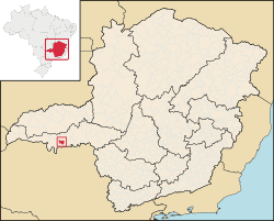
23:Location of Pirajuba in the state of Minas Gerais
8:
182:with 0.568. Nationally the highest was
202:
312:List of municipalities in Minas Gerais
282:
280:
278:
34:in the west of the Brazilian state of
7:
14:
178:with 0.841, while the lowest was
359:Municipalities in Minas Gerais
50:and means "yellow fish", from
1:
375:
46:"Pirajuba" comes from the
103:Important distances are:
156:Human Development Index
222:"Curso de Tupi Antigo"
24:
335:19.90778°S 48.69917°W
92:Conceição das Alagoas
22:
340:-19.90778; -48.69917
146:Health and education
331: /
133:Economic activities
184:São Caetano do Sul
167:Literacy rate: 88%
25:
72:Triângulo Mineiro
366:
346:
345:
343:
342:
341:
336:
332:
329:
328:
327:
324:
300:
295:
289:
284:
273:
268:
262:
261:
259:
258:
249:. Archived from
243:
237:
236:
234:
233:
224:. Archived from
218:
212:
207:
190:in the state of
86:Comendador Gomes
374:
373:
369:
368:
367:
365:
364:
363:
349:
348:
339:
337:
333:
330:
325:
322:
320:
318:
317:
308:
303:
296:
292:
285:
276:
269:
265:
256:
254:
245:
244:
240:
231:
229:
220:
219:
215:
208:
204:
200:
176:Poços de Caldas
148:
135:
64:
44:
17:
12:
11:
5:
372:
370:
362:
361:
351:
350:
315:
314:
307:
304:
302:
301:
290:
274:
263:
238:
213:
201:
199:
196:
172:
171:
168:
165:
162:
159:
158:: 0.786 (2000)
147:
144:
134:
131:
130:
129:
128:: 138 km
123:
117:
111:
108:Belo Horizonte
101:
100:
94:
88:
82:
63:
60:
43:
40:
15:
13:
10:
9:
6:
4:
3:
2:
371:
360:
357:
356:
354:
347:
344:
313:
310:
309:
305:
299:
294:
291:
288:
283:
281:
279:
275:
272:
267:
264:
253:on 2008-02-23
252:
248:
242:
239:
228:on 2012-08-09
227:
223:
217:
214:
211:
206:
203:
197:
195:
193:
189:
185:
181:
177:
169:
166:
163:
160:
157:
153:
152:
151:
145:
143:
139:
132:
127:
124:
121:
118:
115:
112:
110:: 565 km
109:
106:
105:
104:
99:
95:
93:
89:
87:
83:
81:
77:
76:
75:
73:
69:
61:
59:
57:
54:("fish") and
53:
49:
48:tupi language
41:
39:
37:
33:
29:
21:
316:
293:
266:
255:. Retrieved
251:the original
247:"Citybrazil"
241:
230:. Retrieved
226:the original
216:
205:
173:
149:
140:
136:
122:: 50 km
116:: 30 km
102:
65:
58:("yellow").
55:
51:
45:
36:Minas Gerais
32:municipality
27:
26:
338: /
271:Highway map
326:48°41′57″W
323:19°54′28″S
298:Frigoletto
257:2008-06-16
232:2012-08-09
198:References
192:Pernambuco
154:Municipal
210:IBGE 2020
180:Setubinha
42:Etymology
353:Category
306:See also
62:Location
28:Pirajuba
126:Uberaba
114:Planura
98:Planura
96:South:
90:East:
84:North:
188:Manari
120:Frutal
80:Frutal
78:West:
68:Frutal
30:is a
287:IBGE
52:pirá
56:îub
355::
277:^
260:.
235:.
Text is available under the Creative Commons Attribution-ShareAlike License. Additional terms may apply.