51:
535:
592:
60:
515:
493:
376:
level to 5.5 m during floods, which can be from one to four per year. The average annual water consumption at the mouth is 1587.18 m3/s, during summer floods it reaches 35,000 m3/s. Ice phenomena have been occurring since mid-October, the autumn ice drift of 7-16 days is accompanied by the formation of
375:
The river's nutrition is mainly snow (60%); rain and groundwater nutrition account for 16 and 24%, respectively. The flood lasts from the beginning of May to the end of June, in the lower reaches until the beginning of July. From July to
October, there is a summer low, interrupted by a rise in the
383:
The ice age is from the end of
October to the middle of May. The ice drift lasts 5-7 days in the upper reaches and up to 10 days in the lower reaches, passes violently, with congestion the level rises by 29.7 m. Winter nutrition is weakened due to the location of the river basin in the
50:
576:
207:
629:
663:
569:
189:
28:
497:
451:
653:
648:
562:
622:
126:
505:
668:
615:
412:
658:
397:
455:
534:
388:
zone and reaches the lowest values of 3-15 m3/s, the total winter runoff is 11% of the annual.
599:
546:
542:
348:
316:
193:
17:
328:
591:
364:
112:
59:
642:
519:
336:
95:
172:
385:
108:
222:
209:
141:
128:
363:
In 1908, an asteroid impacted near the river and later became known as the
492:
303:
377:
299:
177:
352:
603:
550:
503:
295:
290:
276:
268:
256:
248:
238:
199:
183:
171:
157:
118:
101:
91:
82:
74:
69:
39:
598:This article related to a river in Russia is a
623:
570:
8:
630:
616:
577:
563:
58:
282:1,750 m/s (62,000 cu ft/s)
260:240,000 km (93,000 sq mi)
510:
424:
396:The river was the set location in the
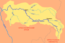
64:Map of the Podkamennaya Tunguska basin
36:
29:Podkamennaya Tunguska (disambiguation)
477:]. ПГК им. Молотова. p. 393.
7:
588:
586:
531:
529:
452:"Podkamennaya Tunguska At Kuz'movka"
602:. You can help Knowledge (XXG) by
549:. You can help Knowledge (XXG) by
25:
664:Krasnoyarsk Krai geography stubs
590:
533:
513:
491:
49:
332:
471:Большая советская энциклопедия
434:Большая советская энциклопедия
201: • coordinates
120: • coordinates
1:
252:1,865 km (1,159 mi)
83:Physical characteristics
432:А. М. Прохоров (1969–1978).
240: • elevation
159: • elevation
498:Podkamennaya Tunguska River
185: • location
103: • location
34:River in Russian Federation
18:Podkamennaya Tunguska River
685:
654:Rivers of Krasnoyarsk Krai
649:Tributaries of the Yenisey
585:
528:
278: • average
163:514 m (1,686 ft)
26:
475:Great Soviet Encyclopedia
469:Б. А. Введенский (1956).
438:Great Soviet Encyclopedia
325:Tunguska under the stones
320:
286:
264:
167:
87:
57:
48:
413:List of rivers of Russia
398:Call of Duty: Black Ops
339:: Ӄо’ль) also known as
545:location article is a
244:28 m (92 ft)
313:Podkamennaya Tunguska
190:Podkamennaya Tunguska
40:Podkamennaya Tunguska
500:at Wikimedia Commons
400:Escalation DLC map,
321:Подкаменная Тунгуска
27:For other uses, see
440:] (in Russian).
291:Basin features
223:61.5944°N 90.1333°E
219: /
138: /
669:Russia river stubs
392:In popular culture
142:57.696°N 104.339°E
78:Russian Federation
611:
610:
558:
557:
496:Media related to
402:Call of The Dead.
309:
308:
16:(Redirected from
676:
632:
625:
618:
594:
587:
579:
572:
565:
543:Krasnoyarsk Krai
537:
530:
518:
517:
516:
509:
495:
479:
478:
466:
460:
459:
454:. Archived from
448:
442:
441:
429:
349:Krasnoyarsk Krai
347:, is a river in
334:
322:
279:
234:
233:
231:
230:
229:
228:61.5944; 90.1333
224:
220:
217:
216:
215:
212:
194:Krasnoyarsk Krai
160:
153:
152:
150:
149:
148:
143:
139:
136:
135:
134:
131:
121:
104:
62:
53:
37:
21:
684:
683:
679:
678:
677:
675:
674:
673:
639:
638:
637:
636:
584:
583:
526:
524:
514:
512:
504:
488:
483:
482:
468:
467:
463:
450:
449:
445:
431:
430:
426:
421:
409:
394:
373:
361:
341:Middle Tunguska
277:
241:
227:
225:
221:
218:
213:
210:
208:
206:
205:
202:
186:
158:
147:57.696; 104.339
146:
144:
140:
137:
132:
129:
127:
125:
124:
119:
102:
65:
44:
41:
35:
32:
23:
22:
15:
12:
11:
5:
682:
680:
672:
671:
666:
661:
659:Tunguska event
656:
651:
641:
640:
635:
634:
627:
620:
612:
609:
608:
595:
582:
581:
574:
567:
559:
556:
555:
538:
523:
522:
502:
501:
487:
486:External links
484:
481:
480:
461:
458:on 2013-04-04.
443:
423:
422:
420:
417:
416:
415:
408:
405:
393:
390:
372:
369:
365:Tunguska event
360:
357:
345:Stony Tunguska
307:
306:
297:
293:
292:
288:
287:
284:
283:
280:
274:
273:
270:
266:
265:
262:
261:
258:
254:
253:
250:
246:
245:
242:
239:
236:
235:
203:
200:
197:
196:
187:
184:
181:
180:
175:
169:
168:
165:
164:
161:
155:
154:
122:
116:
115:
113:Irkutsk Oblast
105:
99:
98:
93:
89:
88:
85:
84:
80:
79:
76:
72:
71:
67:
66:
63:
55:
54:
46:
45:
43:Stony Tunguska
42:
33:
24:
14:
13:
10:
9:
6:
4:
3:
2:
681:
670:
667:
665:
662:
660:
657:
655:
652:
650:
647:
646:
644:
633:
628:
626:
621:
619:
614:
613:
607:
605:
601:
596:
593:
589:
580:
575:
573:
568:
566:
561:
560:
554:
552:
548:
544:
539:
536:
532:
527:
521:
511:
507:
499:
494:
490:
489:
485:
476:
472:
465:
462:
457:
453:
447:
444:
439:
435:
428:
425:
418:
414:
411:
410:
406:
404:
403:
399:
391:
389:
387:
381:
379:
370:
368:
366:
358:
356:
354:
350:
346:
342:
338:
333:Дулгу Катэнӈа
330:
326:
318:
314:
305:
301:
298:
294:
289:
285:
281:
275:
271:
267:
263:
259:
255:
251:
247:
243:
237:
232:
204:
198:
195:
191:
188:
182:
179:
176:
174:
170:
166:
162:
156:
151:
123:
117:
114:
110:
106:
100:
97:
94:
90:
86:
81:
77:
73:
68:
61:
56:
52:
47:
38:
30:
19:
604:expanding it
597:
551:expanding it
540:
525:
474:
470:
464:
456:the original
446:
437:
433:
427:
401:
395:
382:
374:
362:
344:
340:
324:
323:, literally
312:
310:
96:Angara Range
296:Progression
226: /
145: /
133:104°20′20″E
643:Categories
419:References
386:permafrost
257:Basin size
214:90°08′00″E
211:61°35′40″N
130:57°41′46″N
109:Rudnogorsk
371:Hydrology
269:Discharge
407:See also
378:ice jams
304:Kara Sea
70:Location
359:History
317:Russian
300:Yenisey
178:Yenisey
75:Country
520:Russia
506:Portal
353:Russia
329:Evenki
272:
249:Length
92:Source
541:This
473:[
436:[
173:Mouth
107:near
600:stub
547:stub
311:The
343:or
337:Ket
645::
380:.
367:.
355:.
351:,
335:,
331::
327:;
319::
302:→
192:,
111:,
631:e
624:t
617:v
606:.
578:e
571:t
564:v
553:.
508::
315:(
31:.
20:)
Text is available under the Creative Commons Attribution-ShareAlike License. Additional terms may apply.