175:
836:
585:. In 1855 Thomas Oakley purchased a 96-acre parcel of land at Section 13 for 96 Pounds Sterling. This property was called Nanda Farm. On the day of Thomas' death, 1 December 1880, he transferred the property to his young grandson James Albert Oakley. James owned Nanda Farm until his death in 1951 when the property then transferred to James' nephews, Albert Charles (Charlie) Oakley and Stanley Thomas Oakley. The property finally left the Oakley family after 112 years, when it was sold in 1967.
152:
33:
182:
667:
542:
Claim on 14 December 2017. The determination granted the
Ngarrindjeri people rights including the right to access and move around the Native Title Land, hunt, fish and gather, share and exchange, use Natural Water Resources, cook and light fires for ceremonial purposes, engage in cultural activities
530:
Nation which consisted of 18 Lakinyeri (clans). Although the population of the
Ngarrindjeri Nation is unknown, it is believed to have been substantial, as the lake and surrounds provided plenty of food and water. The Ngarrindjeri name for the end of Sturt Peninsula was "Tipping", which meant "the
600:
and native pines were harvested for fuel for paddle steamers. The peninsula comprises a sand dune capped with secondary limestone, which provided many challenges to farmers trying to plough their fields. However, the stones were a very useful resource for building houses and fences. Many of the
785:
1036:
601:
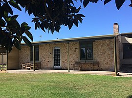
original buildings and stone fences are still standing and are a distinctive feature of what is now Point Sturt. A good example of this architectural element can be seen today in its original form at Nanda Farm (see photo).
531:
lips". Contact with
Europeans and subsequent exposure to various diseases in the early 1800s had a devastating effect on the Ngarrindjeri population, and many people died. Many others were displaced or forcibly removed to
786:"Search result for "Point Sturt, LOCB" with the following datasets selected – "Suburbs and Localities", "Counties", "Local Government Areas", "SA Government Regions" and "Gazetteer""
609:
Boundaries were created on 31 August 2000 for the locality which was given the " long established local name" which is derived from the point at the east end of the Sturt
Peninsula.
1134:
380:
368:
955:
622:
Point Sturt is home to the
Eastern Grey Kangaroo and Echidna. The lake provides good breeding zones for the abundant bird life and is a natural habitat for the
174:
578:
356:
1127:
332:
1165:
571:
to Lake
Alexandrina to ascertain its extent and outflows. Point Sturt was the name they gave to their landing place at the end of the Peninsula.
548:
994:
903:
544:
501:
It is made up of rural living land holdings, primary production and grazing land. The beginning of Point Sturt Road is about 4 km from
207:
1120:
1084:
875:
739:
For the 2016 census, the State Suburb of Point Sturt consisted of the locality of Point Sturt and the southern part of the locality of
487:
1445:
1270:
1240:
449:
440:
428:
413:
408:
116:
1281:
568:
694:
owns a 68 hectare outdoor education site at Point Sturt, conducting a 2-week program at the site for Year 10 students each year.
1195:
814:
1368:
1333:
1311:
1200:
444:
54:
1327:
1230:
1225:
1220:
1037:"Search result for "Sturt Peninsula, PEN" with the following datasets selected – "Suburbs and Localities" and "Gazetteer""
711:
373:
97:
1170:
697:
Over recent years, revegetation of various land holdings has been undertaken by Point Sturt and
Districts Landcare Group.
1419:
1388:
1383:
1363:
1322:
1317:
1276:
691:
435:
420:
349:
344:
200:
69:
50:
646:
and many other birds at various times of the year. Reptiles include
Turtles, Blue Tongue Lizards, Shingleback Lizards,
1245:
1409:
1306:
1260:
1414:
1404:
1393:
1291:
1286:
1160:
1155:
76:
1353:
1250:
43:
1398:
1348:
1338:
1210:
1180:
1373:
1175:
1343:
1301:
1235:
1205:
564:
532:
510:
1102:
83:
1424:
1378:
1296:
1265:
1255:
1215:
1185:
740:
651:
560:
538:
The native title rights and interests of the
Ngarrindjeri people were recognised in Ngarrindjeri and Others
506:
495:
403:
323:
243:
930:
688:
On the
Australia Day long weekend the Milang-Goolwa Freshwater Classic yacht race sails around Point Sturt.
818:
593:
265:
247:
65:
574:
By the early 1850s the land on the Sturt Peninsula was divided into sections and sold to settlers.
491:
317:
293:
1144:
715:
647:
361:
337:
1112:
623:
853:
990:
679:
635:
582:
275:
707:
385:
17:
559:
The Sturt Peninsula was discovered in December 1837 by a team of European explorers led by
835:
479:
142:
90:
1062:
589:
678:
Part of Point Sturt is a designated conservation area and the area is designated as a
1439:
597:
577:
Early European settlers include dairy cattle breeder John H. Yelland, sheepfarmers
543:
and protect cultural sites. All waterways and possibly land parcels are within the
539:
527:
151:
1190:
960:
655:
631:
502:
32:
627:
303:
1010:
222:
209:
509:. At the end of Point Sturt road there are views across Lake Alexandrina to
284:
299:
931:"Federal electoral division of Mayo, boundary gazetted 16 December 2011"
1017:. Vol. I, no. 10. South Australia. 20 January 1838. p. 3
685:
Lake activities – sailing, kayaking, windsurfing, fishing and swimming.
280:
666:
675:
Most of the land at Point Sturt is used for cattle and sheep grazing.
490:
about 71 kilometres (44 mi) south-east of the state capital of
494:
and about 17 kilometres (11 mi) east of the municipal seat of
665:
639:
989:. The Point Sturt and Districts Landcare Group Inc. p. 22.
643:
1116:
26:
156:
Original stone settlers cottage at Nanda Farm, Point Sturt (
588:
Most of the native vegetation including dense woodlands of
908:(Map). Electoral District Boundaries Commission. 2016
463:
379:
367:
355:
343:
331:
310:
291:
274:
264:
254:
238:
199:
136:
57:. Unsourced material may be challenged and removed.
581:and Thomas Oakley, and pastoralist and politician
547:with developments requiring approval through the
392:
876:"Fleurieu Kangaroo Island SA Government region"
1063:"Manning index of South Australian placenames"
1015:South Australian Gazette And Colonial Register
1128:
535:as Europeans took over the land for farming.
8:
809:
807:
1085:"Wayback Machine has not archived that URL"
854:"Postcode for Point Sturt, South Australia"
1135:
1121:
1113:
1025:– via National Library of Australia.
848:
846:
844:
834:
706:Point Sturt is located within the federal
670:Pelicans flying over the Lake Alexandrina.
150:
133:
526:The area was originally inhabited by the
478:is a locality in the Australian state of
117:Learn how and when to remove this message
985:King and Allnut, Alan and Bruce (2017).
956:"Streetview from the end of Point Sturt"
756:
732:
987:The Hundred of Alexandrina "A History"
898:
896:
780:
549:Registered Native Title Body Corporate
925:
923:
778:
776:
774:
772:
770:
768:
766:
764:
762:
760:
714:and the local government area of the
433:
418:
401:
394:
7:
980:
978:
55:adding citations to reliable sources
881:. The Government of South Australia
682:site of international significance.
181:
1065:. State Library of South Australia
25:
936:. Australian Electoral Commission
180:
173:
31:
815:Australian Bureau of Statistics
42:needs additional citations for
1103:"Australian Wetlands Database"
397:Localities around Point Sturt:
316:71 km (44 mi) SE of
1:
1043:. South Australian government
792:. South Australian government
712:electoral district of Hammond
605:Establishment of the locality
322:17 km (11 mi) E of
157:
1143:Towns and localities of the
819:"Point Sturt (state suburb)"
567:who travelled by water from
350:Fleurieu and Kangaroo Island
258:1850s (private sub-division)
18:Point Sturt, South Australia
1462:
1151:
856:. postcodes-australia.com
579:George and William Pearce
455:
395:
391:
260:31 August 2000 (locality)
168:
149:
1446:Towns in South Australia
565:Young Bingham Hutchinson
545:Native Title legislation
242:69 (shared with part of
743:south of Landseer Road.
561:Thomas Bewes Strangways
507:Milang, South Australia
505:and 9 km south of
223:35.492196°S 138.96868°E
131:Town in South Australia
1041:Location SA Map Viewer
823:2016 Census QuickStats
790:Location SA Map Viewer
671:
669:
228:-35.492196; 138.96868
486:on the west side of
469:Adjoining localities
51:improve this article
1145:Alexandrina Council
1011:"To His Excellency"
716:Alexandrina Council
555:European settlement
381:Federal division(s)
369:State electorate(s)
338:Alexandrina Council
219: /
1171:Blackfellows Creek
692:Westminster School
672:
624:Australian Pelican
522:Traditional Owners
1433:
1432:
1323:Mount Observation
1318:Mount Magnificent
996:978-0-646-97029-5
652:Red Bellied Black
636:Cape Barren Goose
583:John Howard Angas
473:
472:
459:
458:
127:
126:
119:
101:
16:(Redirected from
1453:
1271:Lake Alexandrina
1241:Hindmarsh Island
1137:
1130:
1123:
1114:
1107:
1106:
1099:
1093:
1092:
1091:. 7 August 2020.
1081:
1075:
1074:
1072:
1070:
1059:
1053:
1052:
1050:
1048:
1033:
1027:
1026:
1024:
1022:
1007:
1001:
1000:
982:
973:
972:
970:
968:
952:
946:
945:
943:
941:
935:
927:
918:
917:
915:
913:
900:
891:
890:
888:
886:
880:
872:
866:
865:
863:
861:
850:
839:
838:
833:
831:
829:
817:(27 June 2017).
811:
802:
801:
799:
797:
782:
744:
737:
708:division of Mayo
488:Lake Alexandrina
450:Lake Alexandrina
441:Hindmarsh Island
429:Lake Alexandrina
414:Lake Alexandrina
409:Lake Alexandrina
393:
292: • Summer (
234:
233:
231:
230:
229:
224:
220:
217:
216:
215:
212:
184:
183:
177:
162:
159:
154:
145:
139:
134:
122:
115:
111:
108:
102:
100:
59:
35:
27:
21:
1461:
1460:
1456:
1455:
1454:
1452:
1451:
1450:
1436:
1435:
1434:
1429:
1282:Langhorne Creek
1246:Highland Valley
1147:
1141:
1111:
1110:
1105:. 21 July 2020.
1101:
1100:
1096:
1083:
1082:
1078:
1068:
1066:
1061:
1060:
1056:
1046:
1044:
1035:
1034:
1030:
1020:
1018:
1009:
1008:
1004:
997:
984:
983:
976:
966:
964:
954:
953:
949:
939:
937:
933:
929:
928:
921:
911:
909:
902:
901:
894:
884:
882:
878:
874:
873:
869:
859:
857:
852:
851:
842:
827:
825:
813:
812:
805:
795:
793:
784:
783:
758:
748:
747:
738:
734:
724:
704:
664:
620:
615:
613:Natural history
607:
557:
524:
519:
484:Sturt Peninsula
482:located on the
480:South Australia
468:
443:
259:
227:
225:
221:
218:
213:
210:
208:
206:
205:
195:
194:
193:
192:
191:
190:
189:
185:
164:
160:
143:South Australia
141:
140:
137:
132:
123:
112:
106:
103:
60:
58:
48:
36:
23:
22:
15:
12:
11:
5:
1459:
1457:
1449:
1448:
1438:
1437:
1431:
1430:
1428:
1427:
1422:
1417:
1412:
1407:
1402:
1396:
1391:
1386:
1381:
1376:
1371:
1366:
1361:
1356:
1351:
1346:
1341:
1336:
1331:
1325:
1320:
1315:
1309:
1304:
1299:
1294:
1289:
1284:
1279:
1274:
1268:
1263:
1258:
1253:
1248:
1243:
1238:
1233:
1228:
1223:
1218:
1213:
1208:
1203:
1198:
1196:Currency Creek
1193:
1188:
1183:
1178:
1173:
1168:
1163:
1158:
1152:
1149:
1148:
1142:
1140:
1139:
1132:
1125:
1117:
1109:
1108:
1094:
1076:
1054:
1028:
1002:
995:
974:
947:
919:
892:
867:
840:
803:
755:
754:
753:
752:
746:
745:
731:
730:
729:
728:
723:
720:
703:
700:
699:
698:
695:
689:
686:
683:
676:
663:
660:
619:
616:
614:
611:
606:
603:
569:Currency Creek
556:
553:
523:
520:
518:
515:
471:
470:
465:
461:
460:
457:
456:
453:
452:
447:
438:
432:
431:
426:
423:
417:
416:
411:
406:
400:
399:
389:
388:
383:
377:
376:
371:
365:
364:
359:
353:
352:
347:
341:
340:
335:
329:
328:
327:
326:
320:
312:
308:
307:
297:
289:
288:
278:
272:
271:
268:
262:
261:
256:
252:
251:
240:
236:
235:
203:
197:
196:
187:
186:
179:
178:
172:
171:
170:
169:
166:
165:
155:
147:
146:
130:
125:
124:
107:September 2018
39:
37:
30:
24:
14:
13:
10:
9:
6:
4:
3:
2:
1458:
1447:
1444:
1443:
1441:
1426:
1423:
1421:
1418:
1416:
1413:
1411:
1410:Willunga Hill
1408:
1406:
1403:
1400:
1397:
1395:
1392:
1390:
1387:
1385:
1382:
1380:
1377:
1375:
1372:
1370:
1369:Prospect Hill
1367:
1365:
1362:
1360:
1357:
1355:
1352:
1350:
1347:
1345:
1342:
1340:
1337:
1335:
1334:Mundoo Island
1332:
1329:
1326:
1324:
1321:
1319:
1316:
1313:
1312:Mount Compass
1310:
1308:
1307:Mosquito Hill
1305:
1303:
1300:
1298:
1295:
1293:
1290:
1288:
1285:
1283:
1280:
1278:
1275:
1272:
1269:
1267:
1264:
1262:
1261:Kuitpo Colony
1259:
1257:
1254:
1252:
1249:
1247:
1244:
1242:
1239:
1237:
1234:
1232:
1229:
1227:
1224:
1222:
1219:
1217:
1214:
1212:
1209:
1207:
1204:
1202:
1201:Dingabledinga
1199:
1197:
1194:
1192:
1189:
1187:
1184:
1182:
1179:
1177:
1174:
1172:
1169:
1167:
1164:
1162:
1159:
1157:
1154:
1153:
1150:
1146:
1138:
1133:
1131:
1126:
1124:
1119:
1118:
1115:
1104:
1098:
1095:
1090:
1086:
1080:
1077:
1064:
1058:
1055:
1042:
1038:
1032:
1029:
1016:
1012:
1006:
1003:
998:
992:
988:
981:
979:
975:
963:
962:
957:
951:
948:
932:
926:
924:
920:
907:
906:
899:
897:
893:
877:
871:
868:
855:
849:
847:
845:
841:
837:
824:
820:
816:
810:
808:
804:
791:
787:
781:
779:
777:
775:
773:
771:
769:
767:
765:
763:
761:
757:
750:
749:
742:
736:
733:
726:
725:
721:
719:
717:
713:
709:
701:
696:
693:
690:
687:
684:
681:
677:
674:
673:
668:
661:
659:
657:
653:
649:
648:Eastern Brown
645:
641:
637:
633:
629:
625:
617:
612:
610:
604:
602:
599:
595:
591:
586:
584:
580:
575:
572:
570:
566:
562:
554:
552:
550:
546:
541:
536:
534:
529:
521:
516:
514:
512:
508:
504:
499:
497:
493:
489:
485:
481:
477:
466:
462:
454:
451:
448:
446:
445:Mundoo Island
442:
439:
437:
434:
430:
427:
424:
422:
419:
415:
412:
410:
407:
405:
402:
398:
390:
387:
384:
382:
378:
375:
372:
370:
366:
363:
360:
358:
354:
351:
348:
346:
342:
339:
336:
334:
330:
325:
321:
319:
315:
314:
313:
309:
305:
301:
298:
295:
290:
286:
282:
279:
277:
273:
269:
267:
263:
257:
253:
249:
245:
241:
237:
232:
204:
202:
198:
176:
167:
153:
148:
144:
135:
129:
121:
118:
110:
99:
96:
92:
89:
85:
82:
78:
75:
71:
68: –
67:
66:"Point Sturt"
63:
62:Find sources:
56:
52:
46:
45:
40:This article
38:
34:
29:
28:
19:
1358:
1328:Mount Jagged
1287:McHarg Creek
1231:Goolwa South
1226:Goolwa North
1221:Goolwa Beach
1156:Angas Plains
1097:
1088:
1079:
1067:. Retrieved
1057:
1047:17 September
1045:. Retrieved
1040:
1031:
1021:17 September
1019:. Retrieved
1014:
1005:
986:
965:. Retrieved
959:
950:
938:. Retrieved
912:17 September
910:. Retrieved
904:
883:. Retrieved
870:
860:17 September
858:. Retrieved
828:17 September
826:. Retrieved
822:
796:16 September
794:. Retrieved
789:
735:
710:, the state
705:
621:
608:
587:
576:
573:
558:
540:Native Title
537:
528:Ngarrindjeri
525:
500:
483:
475:
474:
396:
128:
113:
104:
94:
87:
80:
73:
61:
49:Please help
44:verification
41:
1420:Woodchester
1389:Strathalbyn
1384:Sandergrove
1364:Port Elliot
1359:Point Sturt
1354:Paris Creek
1277:Lake Plains
1251:Hope Forest
1191:Clayton Bay
967:22 December
961:Google Maps
662:Current use
656:Tiger Snake
503:Clayton Bay
476:Point Sturt
436:Clayton Bay
425:Point Sturt
421:Clayton Bay
266:Postcode(s)
255:Established
248:2016 census
226: /
214:138°58′07″E
201:Coordinates
188:Point Sturt
161: 1855
138:Point Sturt
1349:Pages Flat
1181:Bull Creek
940:25 January
722:References
702:Governance
628:Black Swan
239:Population
211:35°29′32″S
77:newspapers
1415:Willyaroo
1405:Tooperang
1394:The Range
1374:Red Creek
1292:Middleton
1176:Bletchley
1166:Belvidere
1161:Ashbourne
751:Citations
467:Locations
464:Footnotes
362:Hindmarsh
304:UTC+10:30
276:Time zone
1440:Category
1399:Tolderol
1339:Nangkita
1302:Montarra
1211:Gemmells
885:17 April
594:Pink Gum
492:Adelaide
318:Adelaide
311:Location
285:UTC+9:30
246:) (
1344:Nurragi
1236:Hartley
1206:Finniss
1069:18 July
958:(Map).
905:Hammond
598:She-oak
533:Raukkan
517:History
511:Raukkan
374:Hammond
91:scholar
1401:(part)
1330:(part)
1314:(part)
1297:Milang
1273:(part)
1266:Kyeema
1256:Kuitpo
1216:Goolwa
1186:Chiton
1089:SAILIS
993:
741:Milang
680:Ramsar
590:Mallee
496:Goolwa
404:Milang
357:County
345:Region
333:LGA(s)
324:Goolwa
244:Milang
93:
86:
79:
72:
64:
1425:Yundi
1379:Salem
934:(PDF)
879:(PDF)
727:Notes
640:Galah
618:Fauna
98:JSTOR
84:books
1071:2015
1049:2018
1023:2018
991:ISBN
969:2018
942:2018
914:2018
887:2017
862:2018
830:2018
798:2018
654:and
644:Ibis
632:Kite
563:and
386:Mayo
300:ACDT
281:ACST
270:5256
70:news
294:DST
53:by
1442::
1087:.
1039:.
1013:.
977:^
922:^
895:^
843:^
821:.
806:^
788:.
759:^
718:.
658:.
650:,
642:,
638:,
634:,
630:,
626:,
596:,
592:,
551:.
513:.
498:.
158:c.
1136:e
1129:t
1122:v
1073:.
1051:.
999:.
971:.
944:.
916:.
889:.
864:.
832:.
800:.
306:)
302:(
296:)
287:)
283:(
250:)
163:)
120:)
114:(
109:)
105:(
95:·
88:·
81:·
74:·
47:.
20:)
Text is available under the Creative Commons Attribution-ShareAlike License. Additional terms may apply.