476:
136:
488:
176:
143:
169:
520:
500:
29:
742:
762:
734:
714:
408:. Geological events occurring many years ago created the diverse topography and drastic elevation changes over the Cascade Range leading to the various climate differences. These climate differences lead to vegetation variety defining the
454:
period dating back over two million years ago, glaciation advancing and retreating repeatedly scoured the landscape leaving deposits of rock debris. The U-shaped cross section of the river valleys is a result of recent glaciation.
391:
danger. During winter months, weather is usually cloudy, but, due to high pressure systems over the
Pacific Ocean that intensify during summer months, there is often little or no cloud cover during the summer.
91:
475:
383:
onto the
Cascades. As a result, the west side of the North Cascades experiences high precipitation, especially during the winter months in the form of snowfall. Because of
817:
347:
from the mountain drains into the
Porcupine Creek, Swamp Creek, and Granite Creek. These three creeks, which nearly encircle the mountain, ultimately empty to the
670:
827:
135:
499:
487:
168:
812:
332:
832:
463:
in combination with glaciation have been the dominant processes which have created the tall peaks and deep valleys of the North
Cascades area.
663:
533:
249:
656:
84:
700:
355:
is significant as the summit rises 3,600 feet (1,100 meters) above
Granite Creek in 1.3 mile (2.1 km).
304:
223:
726:
719:
695:
328:
807:
436:
308:
292:
213:
822:
340:
64:
54:
74:
371:
originating in the
Pacific Ocean travel northeast toward the Cascade Mountains. As fronts approach the
28:
605:
Beckey, Fred W. Cascade Alpine Guide, Climbing and High Routes. Seattle, WA: Mountaineers Books, 2008.
420:
432:
415:
The history of the formation of the
Cascade Mountains dates back millions of years ago to the late
748:
648:
352:
264:
364:
525:
460:
384:
376:
244:
784:
767:
707:
444:
405:
372:
344:
336:
324:
320:
237:
230:
801:
424:
401:
368:
755:
690:
348:
281:
339:, 2.19 miles (3.52 km) to the southeast. Porcupine Peak can be seen from the
779:
774:
564:
451:
515:
288:
106:
93:
409:
388:
380:
343:
which follows below the southwest slopes of the mountain. Precipitation
456:
440:
428:
269:
400:
The North
Cascades features some of the most rugged topography in the
582:
416:
44:
652:
379:), causing them to drop their moisture in the form of rain or
375:, they are forced upward by the peaks of the Cascade Range (
303:
is a 7,762-foot-elevation (2,366-meter) mountain located in
505:
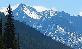
Mt. Hardy (left), Golden Horn, and
Porcupine Peak (right)
327:
Range. It is situated north of Rainy Pass and south of
387:, snow tends to be wet and heavy, resulting in high
33:
Porcupine Peak from eastbound North
Cascades Highway
280:
275:
263:
258:
243:
229:
219:
209:
201:
122:
83:
73:
63:
53:
43:
38:
21:
431:persisted. In addition, small fragments of the
679:Places adjacent to Porcupine Peak (Washington)
664:
16:Mountain in Washington (state), United States
8:
632:
630:
628:
626:
367:climate zone of western North America. Most
613:
611:
671:
657:
649:
639:The Natural History of Puget Sound Country
18:
545:
471:
818:Mountains of Skagit County, Washington
175:
142:
7:
828:North Cascades of Washington (state)
686:
559:
557:
555:
553:
551:
549:
404:with craggy peaks, ridges, and deep
493:South aspect, from Maple Pass trail
333:Okanogan–Wenatchee National Forest
188:Porcupine Peak (the United States)
14:
641:. University of Washington Press.
363:Porcupine Peak is located in the
760:
740:
732:
712:
518:
498:
486:
474:
174:
167:
141:
134:
27:
813:Mountains of Washington (state)
617:
534:Geography of the North Cascades
481:East aspect from Cutthroat Pass
319:Porcupine Peak is part of the
158:Show map of Washington (state)
1:
833:North American 2000 m summits
761:
713:
335:. The nearest higher peak is
191:Show map of the United States
741:
733:
583:"Porcupine Peak - 7,762' WA"
565:"Porcupine Peak, Washington"
447:about 50 million years ago.
331:on land administered by the
323:which is a sub-range of the
49:7,762 ft (2,366 m)
637:Kruckeberg, Arthur (1991).
79:2.19 mi (3.52 km)
849:
684:
429:volcanic igneous activity
127:
26:
107:48.550271°N 120.736653°W
59:922 ft (281 m)
437:continental lithosphere
341:North Cascades Highway
155:Location in Washington
112:48.550271; -120.736653
421:North American Plate
103: /
749:Constitution Crags
385:maritime influence
353:Topographic relief
39:Highest point
795:
794:
790:
789:
365:marine west coast
298:
297:
840:
764:
763:
744:
743:
736:
735:
716:
715:
687:
673:
666:
659:
650:
643:
642:
634:
621:
615:
606:
603:
597:
596:
594:
593:
579:
573:
572:
561:
528:
526:Mountains portal
523:
522:
521:
502:
490:
478:
419:Epoch. With the
284:
233:
192:
178:
177:
171:
159:
145:
144:
138:
118:
117:
115:
114:
113:
108:
104:
101:
100:
99:
96:
31:
19:
848:
847:
843:
842:
841:
839:
838:
837:
798:
797:
796:
791:
745:
680:
677:
647:
646:
636:
635:
624:
616:
609:
604:
600:
591:
589:
587:listsofjohn.com
581:
580:
576:
563:
562:
547:
542:
524:
519:
517:
514:
509:
506:
503:
494:
491:
482:
479:
469:
423:overriding the
406:glacial valleys
398:
377:orographic lift
361:
317:
282:
253:Washington Pass
231:
197:
196:
195:
194:
193:
190:
189:
186:
185:
184:
183:
179:
162:
161:
160:
157:
156:
153:
152:
151:
150:
146:
111:
109:
105:
102:
97:
94:
92:
90:
89:
34:
17:
12:
11:
5:
846:
844:
836:
835:
830:
825:
820:
815:
810:
808:North Cascades
800:
799:
793:
792:
788:
787:
785:Cutthroat Peak
782:
777:
771:
770:
768:Hinkhouse Peak
765:
758:
752:
751:
746:
738:Porcupine Peak
731:
729:
723:
722:
717:
710:
708:Graybeard Peak
704:
703:
701:Tower Mountain
698:
693:
685:
682:
681:
678:
676:
675:
668:
661:
653:
645:
644:
622:
607:
598:
574:
569:Peakbagger.com
544:
543:
541:
538:
537:
536:
530:
529:
513:
510:
508:
507:
504:
497:
495:
492:
485:
483:
480:
473:
470:
468:
465:
445:North Cascades
427:, episodes of
412:in this area.
397:
394:
373:North Cascades
369:weather fronts
360:
357:
337:Cutthroat Peak
325:North Cascades
321:Okanogan Range
316:
313:
301:Porcupine Peak
296:
295:
286:
278:
277:
273:
272:
267:
261:
260:
256:
255:
247:
241:
240:
238:North Cascades
235:
227:
226:
221:
217:
216:
211:
207:
206:
203:
199:
198:
187:
182:Porcupine Peak
181:
180:
173:
172:
166:
165:
164:
163:
154:
149:Porcupine Peak
148:
147:
140:
139:
133:
132:
131:
130:
129:
128:
125:
124:
120:
119:
87:
81:
80:
77:
71:
70:
67:
61:
60:
57:
51:
50:
47:
41:
40:
36:
35:
32:
24:
23:
22:Porcupine Peak
15:
13:
10:
9:
6:
4:
3:
2:
845:
834:
831:
829:
826:
824:
823:Cascade Range
821:
819:
816:
814:
811:
809:
806:
805:
803:
786:
783:
781:
778:
776:
773:
772:
769:
766:
759:
757:
754:
753:
750:
747:
739:
730:
728:
725:
724:
721:
718:
711:
709:
706:
705:
702:
699:
697:
694:
692:
689:
688:
683:
674:
669:
667:
662:
660:
655:
654:
651:
640:
633:
631:
629:
627:
623:
619:
614:
612:
608:
602:
599:
588:
584:
578:
575:
570:
566:
560:
558:
556:
554:
552:
550:
546:
539:
535:
532:
531:
527:
516:
511:
501:
496:
489:
484:
477:
472:
466:
464:
462:
458:
453:
448:
446:
442:
438:
434:
430:
426:
425:Pacific Plate
422:
418:
413:
411:
407:
403:
402:Cascade Range
395:
393:
390:
386:
382:
378:
374:
370:
366:
358:
356:
354:
350:
346:
342:
338:
334:
330:
326:
322:
314:
312:
310:
306:
305:Skagit County
302:
294:
290:
287:
285:
283:Easiest route
279:
274:
271:
268:
266:
262:
257:
254:
251:
248:
246:
242:
239:
236:
234:
228:
225:
222:
218:
215:
212:
208:
205:United States
204:
200:
170:
137:
126:
121:
116:
88:
86:
82:
78:
76:
72:
68:
66:
62:
58:
56:
52:
48:
46:
42:
37:
30:
25:
20:
756:Repulse Peak
737:
691:Kitling Peak
638:
601:
590:. Retrieved
586:
577:
568:
449:
443:created the
414:
399:
362:
349:Skagit River
318:
300:
299:
293:class 3
265:Type of rock
252:
232:Parent range
780:Crooked Bum
775:Corteo Peak
727:Fisher Peak
720:The Needles
696:Mount Hardy
452:Pleistocene
450:During the
329:Mount Hardy
315:Description
110: /
98:120°44′12″W
85:Coordinates
65:Parent peak
802:Categories
592:2023-08-05
540:References
410:ecoregions
309:Washington
289:Scrambling
214:Washington
95:48°33′01″N
69:Peak 7865
55:Prominence
389:avalanche
123:Geography
75:Isolation
45:Elevation
512:See also
461:faulting
441:terranes
381:snowfall
276:Climbing
245:Topo map
620:, p. 16
467:Gallery
439:called
433:oceanic
396:Geology
359:Climate
311:state.
270:Granite
259:Geology
202:Country
618:Beckey
457:Uplift
417:Eocene
345:runoff
224:Skagit
220:County
210:State
459:and
435:and
250:USGS
307:of
804::
625:^
610:^
585:.
567:.
548:^
351:.
291:,
672:e
665:t
658:v
595:.
571:.
Text is available under the Creative Commons Attribution-ShareAlike License. Additional terms may apply.