121:
108:
33:
185:
128:
331:
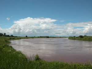
in order to make sea transport to Malawi viable. The Shire merges with the
Zambezi River, near Caia, Mozambique, and the Zambezi then flows into the Indian Ocean. As of September, 2010, some of the main concrete work on the jetty was complete and the port was officially declared open in a ceremony
332:
attended by
President Bingu wa Mutharika of Malawi and President Robert Mugabe of Zimbabwe. However, by August 2016 the port was still incomplete and unused, despite a feasibility study with positive results concluded a few months earlier, and talks were being held on restarting the project.
452:
417:
507:
441:
147:
80:
463:
244:
340:
Nsanje lies only about 46 meters above sea level. During the summer months, daytime highs can exceed 120 °F (49 °C).
58:
120:
304:
43:
62:
47:
249:
269:
202:
54:
288:
502:
319:
and remains closed. The main road north connecting the city to the rest of Malawi is being upgraded.
316:
209:
283:, further north, passing through the city of Nsanje, in the center, and arriving in the city of
312:
197:
265:
214:
496:
284:
453:
World
Gazetteer: Malawi: largest cities and towns and statistics of their population
300:
107:
328:
276:
32:
478:
465:
162:
149:
234:
17:
287:, in the south, even crossing the Mozambican border, covering the town of
308:
279:
valley has formed an extensive urbanized zone that runs from the city of
280:
190:
26:
327:
A project is currently underway to dredge part of the
243:
233:
225:
220:
208:
196:
178:
98:
418:"2018 Population and Housing Census Main Report"
8:
412:
410:
508:Populated places in Southern Region, Malawi
307:. The railway through Nsanje that connects
61:. Unsourced material may be challenged and
95:
81:Learn how and when to remove this message
347:
275:The intense urbanization in the fertile
406:
232:
219:
177:
142:
113:
104:
299:The city has a railway station on the
242:
224:
207:
195:
7:
423:. Malawi National Statistical Office
59:adding citations to reliable sources
25:
183:
126:
119:
106:
93:Place in Southern Region, Malawi
31:
315:was severely disrupted by the
127:
1:
305:Central East African Railways
442:Nyasa Times, August 15, 2016
524:
270:Southern Region of Malawi
143:
114:
105:
303:, under concession of
289:Vila Nova de Fronteira
264:) is the main city in
479:16.91667°S 35.26667°E
163:16.91667°S 35.26667°E
317:Mozambique Civil War
55:improve this section
484:-16.91667; 35.26667
475: /
168:-16.91667; 35.26667
159: /
226: • Total
135:Location in Malawi
398:
397:
313:Beira, Mozambique
255:
254:
91:
90:
83:
16:(Redirected from
515:
490:
489:
487:
486:
485:
480:
476:
473:
472:
471:
468:
455:
450:
444:
439:
433:
432:
430:
428:
422:
414:
348:
189:
187:
186:
174:
173:
171:
170:
169:
164:
160:
157:
156:
155:
152:
130:
129:
123:
110:
96:
86:
79:
75:
72:
66:
35:
27:
21:
523:
522:
518:
517:
516:
514:
513:
512:
493:
492:
483:
481:
477:
474:
469:
466:
464:
462:
461:
459:
458:
451:
447:
440:
436:
426:
424:
420:
416:
415:
408:
403:
346:
338:
325:
297:
266:Nsanje District
215:Nsanje District
203:Southern Region
184:
182:
167:
165:
161:
158:
153:
150:
148:
146:
145:
139:
138:
137:
136:
133:
132:
131:
101:
94:
87:
76:
70:
67:
52:
36:
23:
22:
15:
12:
11:
5:
521:
519:
511:
510:
505:
495:
494:
457:
456:
445:
434:
405:
404:
402:
399:
396:
395:
392:
388:
387:
384:
380:
379:
376:
372:
371:
368:
364:
363:
360:
356:
355:
352:
345:
342:
337:
334:
324:
321:
296:
293:
253:
252:
247:
241:
240:
237:
231:
230:
227:
223:
222:
218:
217:
212:
206:
205:
200:
194:
193:
180:
176:
175:
141:
140:
134:
125:
124:
118:
117:
116:
115:
112:
111:
103:
102:
99:
92:
89:
88:
39:
37:
30:
24:
14:
13:
10:
9:
6:
4:
3:
2:
520:
509:
506:
504:
501:
500:
498:
491:
488:
454:
449:
446:
443:
438:
435:
419:
413:
411:
407:
400:
393:
390:
389:
385:
382:
381:
377:
374:
373:
369:
366:
365:
361:
358:
357:
353:
350:
349:
343:
341:
335:
333:
330:
322:
320:
318:
314:
310:
306:
302:
294:
292:
290:
286:
282:
278:
273:
271:
267:
263:
259:
251:
248:
246:
238:
236:
228:
216:
213:
211:
204:
201:
199:
192:
181:
172:
144:Coordinates:
122:
109:
97:
85:
82:
74:
64:
60:
56:
50:
49:
45:
40:This section
38:
34:
29:
28:
19:
460:
448:
437:
425:. Retrieved
344:Demographics
339:
326:
301:Sena railway
298:
274:
261:
257:
256:
77:
71:January 2017
68:
53:Please help
41:
503:Shire River
482: /
427:25 December
354:Population
329:Shire River
277:Shire River
268:within the
262:Port Herald
166: /
18:Port Herald
497:Categories
470:35°16′00″E
467:16°55′00″S
401:References
260:(formerly
221:Population
154:35°16′00″E
151:16°55′00″S
295:Transport
235:Time zone
42:does not
323:Shipping
309:Blantyre
210:District
394:26,844
386:20,179
378:16,987
370:11,009
336:Climate
281:Bangula
245:Climate
179:Country
63:removed
48:sources
362:6,091
258:Nsanje
229:26,844
198:Region
191:Malawi
188:
100:Nsanje
421:(PDF)
391:2018
383:2008
375:1998
367:1987
359:1977
351:Year
311:with
285:Marka
429:2019
46:any
44:cite
57:by
499::
409:^
291:.
272:.
250:Aw
239:+2
431:.
84:)
78:(
73:)
69:(
65:.
51:.
20:)
Text is available under the Creative Commons Attribution-ShareAlike License. Additional terms may apply.