46:
71:
271:(4,245 ft) less than 3 kilometres (1.9 mi) from the shore. The village of Ota is 5 kilometres (3.1 mi) from the sea on a slope below the 1,220 metres (4,000 ft) crest of Andatone. It is surrounded by olive groves, holm oaks and chestnut trees. Upstream of Ota a dominant position named U Castellu was settled in prehistoric times, and later was the site of a castle that controlled access to Porto from the fertile valleys of the high mountain territory.
300:
29:
1252:
1117:
250:
1079:
78:
53:
291:
which higher up gives way to a more open terrain. Edward Lear wrote in 1868 “Look at the high peaks, beyond the pass, the massive dark pine forest contrasts with the golden green undulations of the birch wood. While strolling in the heart of a shaded valley, you notice the lights on the road, or the immaculate snow on the verges. Omnipresent beauty."
270:
The lower and middle parts of the valley are in the Sevi Infora landscape. The Porto river descends to the coast through a deep and narrow valley. There is luxuriant vegetation in the valley floor below bare rocky walls. The walls of the valley, which is not visible from the sea, rise to 1,294 metres
261:
was built by the
Genoese, and stands on a rocky promontory looking over the sea. It has been renovated and hosts an exhibit on the fortifications of the Corsican shores. The coastal village has large buildings that seem inappropriate for a small settlement that cannot expand due to lack of available
290:
The upper valley is in the Sevi
Ingrentu landscape, and contains the valleys of the Lonca and Aïtone tributaries of the Porto, and the Tavulella tributary of the Aïtone. The three valleys are almost parallel, and are oriented southwest. Each valley has a narrow gorge cut into the mountain barrier,
225:. The source is at an elevation of 1,571 metres (5,154 ft). It flows in a generally southwest direction to the village of Cristinacce, then west past the villages of Évisa, Marignana and Ota to enter the Golfe de Porto in the village of Porto. The D84 road follows the lower part of the river.
285:
The northern part of this gorge, in the territory of Ota, is home to thriving crops, olive trees, terraced vines; opposite, where the forest road blossoms, a wild, different universe prevails: chasms, chestnut trees with dazzling spring adornments emerge among the ferns, foxgloves, fields of
307:
Measurements of the river flow were taken at the Ota station from 1996 to 2021. The watershed above this station covers 103 square kilometres (40 sq mi). The maximum daily flow was 145 cubic metres per second (5,100 cu ft/s) recorded on 6 November 2000. Average annual
1440:
240:
The
Pianella Bridge spans the Porto at Ponte-Vecchju in Ota. The Pianella bridge, which dates from the fifteenth century, was classified as a historic monument by decree of November 29, 1976.
1059:
308:
precipitation was calculated as 890 millimetres (35 in). The average flow of water throughout the year was 2.89 cubic metres per second (102 cu ft/s).
286:
cyclamen, enhanced by the livid bells of amaryllis. During this ascent, the gigantic mountains glimpsed through the side openings of the Ota valley are revealed.
1052:
1037:
45:
237:
The Zaglia Bridge crosses the
Tavulella stream in the gorges of Spelunca. It was classified as a Historic Monument by decree of June 26, 1990.
710:
1045:
1406:
1068:
144:
70:
1396:
221:. It rises in the Cristinacce commune to the south of the 1,712 metres (5,617 ft) Capu a Rughia, just west of the border with
1430:
1391:
1019:
1435:
905:
1106:
884:
926:
1141:
1101:
999:
1177:
299:
28:
1172:
197:) is a small coastal river in the northwest of the department of Corse-du-Sud, Corsica, France.
967:
947:
262:
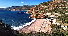
land. There is a pebble beach, and behind the coastal barrier there are eucalyptus plantations.
218:
130:
1167:
1162:
962:
942:
1316:
1266:
1146:
915:(in French), Direction régionale de l’environnement, de l’aménagement et du logement Corse
894:(in French), Direction régionale de l’environnement, de l’aménagement et du logement Corse
190:
1372:
1311:
1306:
1251:
1424:
1131:
1116:
1301:
1182:
1136:
1072:
249:
113:
982:
1360:
1354:
1226:
274:
222:
206:
125:
1286:
1236:
688:
686:
205:
The Porto is 23.3 kilometres (14.5 mi) long. It crosses the communes of
159:
146:
1276:
1231:
1216:
312:
Average flow (cubic meters per second) by month for the period 1996 to 2021
214:
1348:
1342:
1296:
1241:
210:
503:) are tributaries of the Porto (ordered by length) and sub-tributaries:
1366:
1321:
1291:
1281:
1271:
1004:
103:
257:
The port of Porto is guarded by a square tower at its entrance. The
931:, Ministère de l'Ecologie, du Développement Durable et de l'Energie
673:
671:
298:
248:
762:
1221:
836:
834:
692:
1041:
785:
783:
746:
744:
233:
Two of the bridges are classified as historical monuments.
863:
861:
709:
sfn error: no target: CITEREFRivière_De_Porto,_Annuaire (
723:
704:
677:
1335:
1259:
1209:
1195:
1155:
1124:
1094:
1087:
735:
316:
175:
136:
124:
119:
109:
99:
94:
21:
1441:Coastal basins of the Mediterranean Sea in Corsica
253:Porto. Genoese tower visible above the river mouth
852:
840:
825:
283:
277:(1812–1888) wrote of the central valley in his
813:
801:
789:
774:
750:
1053:
8:
1199:
1091:
1060:
1046:
1038:
867:
631:Erbaghiu Vecchiu: 2 km (1.2 mi)
1204:Clockwise: east to south to west to north
310:
279:Journal of an English Landscape Designer
667:
520:Casa Infurcata: 2 km (1.2 mi)
511:Forca Ai Tassi: 4 km (2.5 mi)
983:"Relation: Rivière de Porto (3307985)"
566:Novali Piani: 1 km (0.62 mi)
18:
913:Atlas des paysages de la Region Corse
892:Atlas des paysages de la Region Corse
763:Tour génoise de Porto, Guide Michelin
563:Punticelli: 1 km (0.62 mi)
517:San Leonardo: 3 km (1.9 mi)
77:
52:
7:
693:Relation: Rivière de Porto (3307985)
654:Pettinelli: 1 km (0.62 mi)
651:Crocicchia: 1 km (0.62 mi)
628:Fiume Seccu: 2 km (1.2 mi)
613:Campi Solcu: 3 km (1.9 mi)
581:Lamatoghiu: 3 km (1.9 mi)
546:Luzzichelli: 2 km (1.2 mi)
514:Calavalonda: 3 km (1.9 mi)
303:Natural pool on the Aitone tributary
592:Pertusella: 2 km (1.2 mi)
584:Campoghiu: 3 km (1.9 mi)
549:Sindacchi: 2 km (1.2 mi)
523:Pozzitondi: 2 km (1.2 mi)
634:La Rocca: 1 km (0.62 mi)
595:Stazzona: 1 km (0.62 mi)
560:Manuella: 1 km (0.62 mi)
552:Carchetu: 1 km (0.62 mi)
543:Casterica: 3 km (1.9 mi)
540:Spurtellu: 5 km (3.1 mi)
14:
645:Aghiola: 1 km (0.62 mi)
642:Bartoli: 1 km (0.62 mi)
603:Vitullu: 4 km (2.5 mi)
587:Pirellu: 1 km (0.62 mi)
537:Aitone: 12 km (7.5 mi)
526:Corgola: 1 km (0.62 mi)
1250:
1115:
1077:
619:Vignale: 2 km (1.2 mi)
606:Piotto: 1 km (0.62 mi)
576:Vitrone: 2 km (1.2 mi)
529:Piscio: 1 km (0.62 mi)
508:Lonca: 15 km (9.3 mi)
76:
69:
51:
44:
27:
657:Rotte: 1 km (0.62 mi)
648:Cotto: 1 km (0.62 mi)
625:Ariola: 2 km (1.2 mi)
573:Enova: 4 km (2.5 mi)
557:Rughia: 2 km (1.2 mi)
532:Lumio: 1 km (0.62 mi)
639:Albia: 2 km (1.2 mi)
622:Faeta: 2 km (1.2 mi)
600:Onda: 3 km (1.9 mi)
138: • coordinates
1:
120:Physical characteristics
16:River in Corse-du-Sud, France
724:Pont de Zaglia, Base Mérimée
616:Riu: 3 km (1.9 mi)
179:23.3 km (14.5 mi)
1457:
705:Rivière De Porto, Annuaire
33:Genoese bridge at Pianella
1386:
1248:
1202:
1113:
963:"Pont génois de Pianella"
478:
464:
450:
436:
422:
408:
394:
380:
366:
352:
338:
324:
319:
38:
26:
678:Rivière de Porto, Sandre
1020:"Tour génoise de Porto"
736:Pont génois de Pianella
499:The following streams (
1431:Rivers of Corse-du-Sud
906:"3.14 - Sevi Ingrentu"
304:
288:
254:
194:
1107:Étang de Santa Giulia
302:
259:Tour génoise de Porto
252:
885:"4.02 - Sevi Infora"
853:3.14 - Sevi Ingrentu
841:3.14 - Sevi Ingrentu
826:3.14 - Sevi Ingrentu
313:
156: /
60:Show map of Corsica
1196:Rivers and streams
1000:"Rivière de Porto"
814:4.02 - Sevi Infora
802:4.02 - Sevi Infora
790:4.02 - Sevi Infora
775:4.02 - Sevi Infora
751:4.02 - Sevi Infora
311:
305:
255:
160:42.2667°N 8.6917°E
85:Show map of France
1418:
1417:
1382:
1381:
1191:
1190:
1102:Étang de Balistra
492:
491:
183:
182:
131:Mediterranean Sea
1448:
1436:Rivers of France
1254:
1200:
1119:
1092:
1082:
1081:
1080:
1062:
1055:
1048:
1039:
1033:
1032:
1031:
1015:
1014:
1013:
995:
994:
993:
978:
977:
976:
958:
957:
956:
943:"Pont de Zaglia"
938:
937:
936:
922:
921:
920:
910:
901:
900:
899:
889:
871:
865:
856:
850:
844:
838:
829:
823:
817:
811:
805:
799:
793:
787:
778:
772:
766:
760:
754:
748:
739:
733:
727:
721:
715:
714:
702:
696:
690:
681:
675:
487:
486:
473:
472:
459:
458:
445:
444:
431:
430:
417:
416:
403:
402:
389:
388:
375:
374:
361:
360:
347:
346:
333:
332:
314:
195:Rivière de Porto
171:
170:
168:
167:
166:
161:
157:
154:
153:
152:
149:
86:
80:
79:
73:
61:
55:
54:
48:
31:
19:
1456:
1455:
1451:
1450:
1449:
1447:
1446:
1445:
1421:
1420:
1419:
1414:
1413:
1402:Bodies of water
1378:
1331:
1255:
1246:
1205:
1187:
1151:
1120:
1111:
1083:
1078:
1076:
1066:
1036:
1029:
1027:
1018:
1011:
1009:
998:
991:
989:
981:
974:
972:
961:
954:
952:
941:
934:
932:
925:
918:
916:
908:
904:
897:
895:
887:
883:
879:
874:
866:
859:
851:
847:
839:
832:
828:, pp. 3–4.
824:
820:
812:
808:
800:
796:
788:
781:
773:
769:
761:
757:
749:
742:
734:
730:
722:
718:
708:
703:
699:
691:
684:
676:
669:
665:
660:
497:
488:
484:
483:
474:
470:
469:
460:
456:
455:
446:
442:
441:
432:
428:
427:
418:
414:
413:
404:
400:
399:
390:
386:
385:
376:
372:
371:
362:
358:
357:
348:
344:
343:
334:
330:
329:
297:
268:
247:
231:
203:
165:42.2667; 8.6917
164:
162:
158:
155:
150:
147:
145:
143:
142:
139:
90:
89:
88:
87:
84:
83:
82:
81:
64:
63:
62:
59:
58:
57:
56:
34:
17:
12:
11:
5:
1454:
1452:
1444:
1443:
1438:
1433:
1423:
1422:
1416:
1415:
1412:
1411:
1410:
1409:
1399:
1394:
1388:
1387:
1384:
1383:
1380:
1379:
1377:
1376:
1370:
1364:
1358:
1352:
1346:
1339:
1337:
1333:
1332:
1330:
1329:
1324:
1319:
1314:
1309:
1304:
1299:
1294:
1289:
1284:
1279:
1274:
1269:
1263:
1261:
1257:
1256:
1249:
1247:
1245:
1244:
1239:
1234:
1229:
1224:
1219:
1213:
1211:
1207:
1206:
1203:
1197:
1193:
1192:
1189:
1188:
1186:
1185:
1180:
1175:
1170:
1165:
1159:
1157:
1153:
1152:
1150:
1149:
1144:
1139:
1134:
1128:
1126:
1122:
1121:
1114:
1112:
1110:
1109:
1104:
1098:
1096:
1089:
1085:
1084:
1067:
1065:
1064:
1057:
1050:
1042:
1035:
1034:
1024:Guide Michelin
1016:
996:
979:
959:
939:
928:Le Porto à Ota
923:
902:
880:
878:
875:
873:
872:
868:Le Porto à Ota
857:
845:
830:
818:
806:
794:
779:
767:
755:
740:
728:
716:
697:
682:
666:
664:
661:
659:
658:
655:
652:
649:
646:
643:
640:
637:
636:
635:
629:
626:
623:
620:
617:
614:
611:
610:
609:
608:
607:
598:
597:
596:
593:
590:
589:
588:
579:
578:
577:
571:
570:
569:
568:
567:
561:
558:
555:
554:
553:
547:
544:
541:
535:
534:
533:
530:
527:
524:
521:
518:
515:
512:
505:
496:
493:
490:
489:
482:
480:
476:
475:
468:
466:
462:
461:
454:
452:
448:
447:
440:
438:
434:
433:
426:
424:
420:
419:
412:
410:
406:
405:
398:
396:
392:
391:
384:
382:
378:
377:
370:
368:
364:
363:
356:
354:
350:
349:
342:
340:
336:
335:
328:
326:
322:
321:
318:
296:
293:
267:
264:
246:
243:
242:
241:
238:
230:
227:
202:
199:
181:
180:
177:
173:
172:
140:
137:
134:
133:
128:
122:
121:
117:
116:
111:
107:
106:
101:
97:
96:
92:
91:
75:
74:
68:
67:
66:
65:
50:
49:
43:
42:
41:
40:
39:
36:
35:
32:
24:
23:
15:
13:
10:
9:
6:
4:
3:
2:
1453:
1442:
1439:
1437:
1434:
1432:
1429:
1428:
1426:
1408:
1405:
1404:
1403:
1400:
1398:
1395:
1393:
1390:
1389:
1385:
1374:
1371:
1368:
1365:
1362:
1359:
1356:
1353:
1350:
1347:
1344:
1341:
1340:
1338:
1334:
1328:
1325:
1323:
1320:
1318:
1315:
1313:
1310:
1308:
1305:
1303:
1300:
1298:
1295:
1293:
1290:
1288:
1285:
1283:
1280:
1278:
1275:
1273:
1270:
1268:
1265:
1264:
1262:
1258:
1253:
1243:
1240:
1238:
1235:
1233:
1230:
1228:
1225:
1223:
1220:
1218:
1215:
1214:
1212:
1208:
1201:
1198:
1194:
1184:
1181:
1179:
1176:
1174:
1171:
1169:
1166:
1164:
1161:
1160:
1158:
1154:
1148:
1145:
1143:
1142:Monte Tignoso
1140:
1138:
1135:
1133:
1130:
1129:
1127:
1123:
1118:
1108:
1105:
1103:
1100:
1099:
1097:
1093:
1090:
1086:
1074:
1070:
1063:
1058:
1056:
1051:
1049:
1044:
1043:
1040:
1025:
1021:
1017:
1007:
1006:
1001:
997:
988:
987:OpenStreetMap
984:
980:
970:
969:
964:
960:
950:
949:
944:
940:
930:
929:
924:
914:
907:
903:
893:
886:
882:
881:
876:
869:
864:
862:
858:
854:
849:
846:
842:
837:
835:
831:
827:
822:
819:
816:, p. 28.
815:
810:
807:
804:, p. 27.
803:
798:
795:
792:, p. 23.
791:
786:
784:
780:
777:, p. 26.
776:
771:
768:
764:
759:
756:
753:, p. 25.
752:
747:
745:
741:
737:
732:
729:
725:
720:
717:
712:
706:
701:
698:
694:
689:
687:
683:
679:
674:
672:
668:
662:
656:
653:
650:
647:
644:
641:
638:
633:
632:
630:
627:
624:
621:
618:
615:
612:
605:
604:
602:
601:
599:
594:
591:
586:
585:
583:
582:
580:
575:
574:
572:
565:
564:
562:
559:
556:
551:
550:
548:
545:
542:
539:
538:
536:
531:
528:
525:
522:
519:
516:
513:
510:
509:
507:
506:
504:
502:
494:
481:
477:
467:
463:
453:
449:
439:
435:
425:
421:
411:
407:
397:
393:
383:
379:
369:
365:
355:
351:
341:
337:
327:
323:
315:
309:
301:
294:
292:
287:
282:
280:
276:
272:
265:
263:
260:
251:
244:
239:
236:
235:
234:
228:
226:
224:
220:
216:
212:
208:
200:
198:
196:
192:
188:
178:
174:
169:
141:
135:
132:
129:
127:
123:
118:
115:
112:
108:
105:
102:
98:
93:
72:
47:
37:
30:
25:
20:
1401:
1326:
1073:Corse-du-Sud
1028:, retrieved
1023:
1010:, retrieved
1003:
990:, retrieved
986:
973:, retrieved
968:Base Mérimée
966:
953:, retrieved
948:Base Mérimée
946:
933:, retrieved
927:
917:, retrieved
912:
896:, retrieved
891:
855:, p. 4.
848:
843:, p. 3.
821:
809:
797:
770:
758:
731:
719:
700:
500:
498:
306:
289:
284:
278:
273:
269:
258:
256:
232:
204:
186:
184:
114:Corse-du-Sud
1407:Haute-Corse
1363:(Rizzanese)
1361:Fiumicicoli
1345:(Rizzanese)
1336:Tributaries
1088:Waterbodies
1075:department
1069:Waterbodies
1026:(in French)
1008:(in French)
971:(in French)
951:(in French)
495:Tributaries
275:Edward Lear
223:Haute-Corse
207:Cristinacce
163: /
1425:Categories
1369:(Prunelli)
1357:(Prunelli)
1287:Butturacci
1260:West coast
1237:Stabiacciu
1210:East coast
1156:Reservoirs
1030:2022-01-10
1012:2022-01-10
992:2022-01-10
975:2022-01-10
955:2022-01-10
935:2022-01-10
919:2022-01-10
898:2022-01-10
663:References
148:42°16′00″N
1397:Landforms
1375:(Liamone)
1351:(Liamone)
1277:Rizzanese
1232:Lagunienu
1217:Solenzara
1178:Rizzanese
501:ruisseaux
295:Hydrology
215:Marignana
151:8°41′30″E
110:Departent
1392:Communes
1349:Cruzzini
1343:Chiuvone
1297:Prunelli
1242:Francolu
1173:Ospedale
281:(1868),
201:Location
95:Location
1367:Gravona
1317:Liamone
1267:Canella
1147:Vitalca
1095:Lagoons
1071:of the
877:Sources
229:Bridges
100:Country
1373:Guagno
1322:Chiuni
1312:Sagone
1307:Liscia
1292:Taravo
1282:Baraci
1272:Ortolo
1168:Ortolo
1163:Figari
1132:Bracca
1005:Sandre
317:Month
266:Valley
191:French
176:Length
104:France
1327:Porto
1183:Tolla
1137:Creno
1125:Lakes
909:(PDF)
888:(PDF)
485:5.710
471:5.510
457:1.750
443:0.759
429:0.196
415:0.269
401:1.040
387:2.280
373:3.360
359:4.470
345:4.660
331:4.880
320:Flow
245:Mouth
211:Évisa
187:Porto
126:Mouth
22:Porto
1302:Lava
1222:Cavu
711:help
479:Dec
465:Nov
451:Oct
437:Sep
423:Aug
409:Jul
395:Jun
381:May
367:Apr
353:Mar
339:Feb
325:Jan
217:and
185:The
1355:Ese
1227:Oso
219:Ota
1427::
1022:,
1002:,
985:,
965:,
945:,
911:,
890:,
860:^
833:^
782:^
743:^
685:^
670:^
213:,
209:,
193::
1061:e
1054:t
1047:v
870:.
765:.
738:.
726:.
713:)
707:.
695:.
680:.
189:(
Text is available under the Creative Commons Attribution-ShareAlike License. Additional terms may apply.