33:
288:
345:
113:, Wharite is perhaps better known in the region for its highly-visible television transmission tower. The first transmitter at Wharite was commissioned in 1963, relaying Wellington's WNTV1 channel (now part of
90:
The highest point in the
Ruahines is Mangaweka, situated along the Hikurangi Range, which at 1733 metres (5686 feet) is the second highest non-volcanic mountainous peak in the North Island after
140:" (Don't disturb the forest of Ruahine, or it will burst into flames!), referring to the fact that attacking tribes often came down into Hawke's Bay through the passes of the Ruahine Range.
329:
440:
168:
386:
226:
415:
322:
242:
Tramping in
Ruahine State Forest Park – A montage of photographs featuring the Hikurangi Range in full winter snow by Derek Watts – New Zealand Herald 2009
425:
445:
405:
231:
315:
410:
249:
207:
105:(920 metres/3017 feet), which visually marks the southern end-point of the Ruahine Range. The dominant geographical landmark in the
241:
379:
430:
420:
60:. The ridge is at its most pronounced from the central North Island down to Wellington, where it comprises the Ruahine,
372:
32:
435:
91:
72:
76:
295:
157:"Parliamentary Debates (Hansard)". Vol. 351. New Zealand Parliament. 28 June 1967. p. 1394.
106:
132:
name believed to mean “wise woman”, with reference to the migrant leader's granddaughter on the
287:
203:
195:
129:
84:
356:
299:
110:
95:
352:
344:
65:
399:
133:
80:
61:
102:
45:
49:
57:
17:
264:
251:
52:
that form a ridge running parallel with the east coast of the island between
53:
232:
Department of
Conservation's section on the Eastern Ruahine Forest Park
227:
Department of
Conservation's section on the Western Ruahine Forest Park
199:
114:
71:
The
Ruahines run northeast–southwest for 110 kilometres from inland
31:
192:
Tuwharetoa: The history of the Maori people of the Taupo
District
236:
79:. It is separated in the south from the northern end of the
117:). The current main transmitter was commissioned in 1966.
360:
303:
44:is the largest of several mountain ranges in the
194:. Auckland : A.H. & A.W. Reed. p. 297.
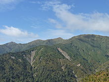
237:Close up image of Wharite peak (tramper.co.nz)
138:Kaua e whakakoria te kuku o Ruahine, kei wera!
380:
323:
8:
387:
373:
330:
316:
169:"Ruahine Forest Park: History and culture"
171:. Department of Conservation, New Zealand
149:
7:
341:
339:
284:
282:
441:Manawatū-Whanganui geography stubs
359:. You can help Knowledge (XXG) by
302:. You can help Knowledge (XXG) by
190:Grace, John Te Herekiekie (1959).
25:
343:
286:
416:Landforms of Manawatū-Whanganui
94:(1754 metres/5755 feet) in the
406:Mountain ranges of New Zealand
355:Region geography article is a
1:
426:Central Hawke's Bay District
446:Hawke's Bay geography stubs
462:
338:
281:
101:The other notable peak is
411:Landforms of Hawke's Bay
298:geography article is a
136:. A local Māori says "
37:
35:
421:Rangitikei District
261: /
296:Manawatū-Whanganui
265:40.000°S 176.100°E
38:
431:Manawatū District
368:
367:
311:
310:
16:(Redirected from
453:
436:Tararua District
389:
382:
375:
347:
340:
332:
325:
318:
290:
283:
276:
275:
273:
272:
271:
270:-40.000; 176.100
266:
262:
259:
258:
257:
254:
214:
213:
187:
181:
180:
178:
176:
165:
159:
158:
154:
111:Tararua District
21:
461:
460:
456:
455:
454:
452:
451:
450:
396:
395:
394:
393:
337:
336:
279:
269:
267:
263:
260:
255:
252:
250:
248:
247:
223:
218:
217:
210:
189:
188:
184:
174:
172:
167:
166:
162:
156:
155:
151:
146:
123:
96:Raukumara Range
66:Remutaka Ranges
28:
23:
22:
15:
12:
11:
5:
459:
457:
449:
448:
443:
438:
433:
428:
423:
418:
413:
408:
398:
397:
392:
391:
384:
377:
369:
366:
365:
348:
335:
334:
327:
320:
312:
309:
308:
291:
245:
244:
239:
234:
229:
222:
221:External links
219:
216:
215:
208:
182:
160:
148:
147:
145:
142:
122:
119:
85:Manawatū Gorge
27:Mountain range
26:
24:
18:Ruahine Ranges
14:
13:
10:
9:
6:
4:
3:
2:
458:
447:
444:
442:
439:
437:
434:
432:
429:
427:
424:
422:
419:
417:
414:
412:
409:
407:
404:
403:
401:
390:
385:
383:
378:
376:
371:
370:
364:
362:
358:
354:
349:
346:
342:
333:
328:
326:
321:
319:
314:
313:
307:
305:
301:
297:
292:
289:
285:
280:
277:
274:
243:
240:
238:
235:
233:
230:
228:
225:
224:
220:
211:
209:9780589003739
205:
201:
197:
193:
186:
183:
170:
164:
161:
153:
150:
143:
141:
139:
135:
131:
127:
120:
118:
116:
112:
108:
104:
99:
97:
93:
88:
86:
82:
81:Tararua Range
78:
74:
69:
67:
63:
59:
55:
51:
47:
43:
42:Ruahine Range
36:Ruahine Range
34:
30:
19:
361:expanding it
350:
304:expanding it
293:
278:
246:
191:
185:
173:. Retrieved
163:
152:
137:
125:
124:
100:
92:Mt Hikurangi
89:
70:
46:North Island
41:
39:
29:
353:Hawke's Bay
268: /
134:Aotea canoe
73:Hawke's Bay
50:New Zealand
400:Categories
200:B0007JE64K
144:References
58:Wellington
77:Woodville
54:East Cape
256:176°06′E
107:Manawatū
75:to near
253:40°00′S
175:12 July
126:Ruahine
103:Wharite
83:by the
62:Tararua
206:
198:
115:TVNZ 1
351:This
294:This
130:Māori
128:is a
357:stub
300:stub
204:ISBN
196:ASIN
177:2019
121:Name
109:and
64:and
56:and
40:The
48:of
402::
202:.
98:.
87:.
68:.
388:e
381:t
374:v
363:.
331:e
324:t
317:v
306:.
212:.
179:.
20:)
Text is available under the Creative Commons Attribution-ShareAlike License. Additional terms may apply.