39:
190:
182:
46:
1104:
1055:
1373:
719:. A ridge which descends from the Deep Freeze Range to Campbell Glacier between Rainey Glacier and Recoil Glacier. Mapped by USGS from surveys and United States Navy air photos, 1960-64. Named by US-ACAN for Lieutenant John L. Archambault, United States Navy, medical officer at McMurdo Station, 1967.
681:. A nunatak in the middle of Campbell Glacier, approximately 9 nautical miles (17 km; 10 mi) from its head. Mapped by USGS from surveys and United States Navy air photos, 1960-64. Named by US-ACAN for David L. Mericle, United States Navy, electronics technician at McMurdo Station, 1967.
205:
and Suture Bench. It flows south past both sides of
Mericle Rock, and is joined from the west by Rainey Glacier. Hedge Terrace forms its eastern side in this section. Below Archambau Ridge it is joined from the west by Recoil Glacier, and past Mount Gibbs it is joined from the southwest by Harper
405:. A tributary glacier on the north side of Archambault Ridge, descending from the Deep Freeze Range into Campbell Glacier. Named by the northern party of NZGSAE, 1962-63, for Denys Rainey, cartographer, who assisted this and other New Zealand Antarctic expeditions with their mapping problems.
843:. A prominent nunatak standing at the east side of the terminus of Campbell Glacier on the north shore of Terra Nova Bay. This feature, a multiple volcanic cone, was so named by the NZGSAE, 1965-66, because it looks like an old Viking shield.
1108:
1059:
447:, to the Campbell Glacier. Named by the northern party of NZGSAE, 1962-63, because the geologist was said to have "recoiled in disgust" on finding little of geological interest there and not what he expected.
1249:
1299:
1219:
1214:
1140:
356:
589:
and flowing northeast to enter the
Campbell Glacier. So named by the Northern Party of NZGSAE, 1965-66, because of the spectacular spill which the party had there.
539:. A tributary glacier descending from the Deep Freeze Range and entering Campbell Glacier 4 nautical miles (7.4 km; 4.6 mi) southeast of the summit of
761:. Mapped by USGS from surveys and United States Navy air photos, 1955-63. Named by US-ACAN for Herman T. Miller, biologist at McMurdo Station, 1965-66 season.
1294:
1259:
1168:
1163:
1325:
1289:
1224:
247:
1264:
799:. The seaward extension of Campbell Glacier into northern Terra Nova Bay. The name was suggested by US-ACAN in association with Campbell Glacier.
1279:
1234:
1133:
1063:
498:
76:
239:
757:. A sharp pointed nunatak rising above the ice at the lower end of Campbell Glacier, 5 nautical miles (9.3 km; 5.8 mi) ESE of
1274:
1269:
1239:
1199:
1184:
1126:
38:
250:. It was named for the leader of this party. The extent of the glacier and its discharge into north Terra Nova Bay, rather than the
1304:
1284:
1189:
1149:
1393:
1204:
1309:
1254:
1209:
1112:
494:
214:. Styx Glacier joins from the east past the end of Wood Ridge. Further south Bates Glacier joins from the west to the north of
1244:
1194:
351:. A tributary glacier in the Southern Cross Mountains, flowing southeast to enter Campbell Glacier between Wood Ridge and
1340:
1335:
1229:
69:
815:
771:
729:
691:
653:
599:
553:
511:
457:
415:
377:
323:
125:
1363:
206:
Glacier. Further south Rebuff
Glacier joins from the west. It continues south past Wood Ridge to the east and the
275:
198:
543:. Named by the northern party of NZGSAE, 1962-63, because the party was prevented from getting access to it.
222:
to the east and Miller
Nunatak to the west, and forms the Campbell Glacier Tongue where it disgorges into
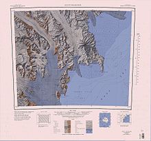
153:) is a glacier, about 60 nautical miles (110 km; 69 mi) long, originating near the south end of
635:. Named by the Northern Party of the NZGSAE, 1965-66, for D.R. Bates, field assistant with that party.
302:
297:
189:
181:
292:
207:
158:
1377:
1345:
628:
497:(USGS) from surveys and United States Navy air photos, 1960-64. Named by the United States
251:
1086:
1070:
219:
162:
808:
758:
540:
352:
227:
223:
166:
111:
1387:
582:
490:
444:
255:
211:
170:
62:
1350:
1037:
586:
238:
The lower end of the glacier was observed by the
Northern Party, led by Lieutenant
501:(US-ACAN) for Wayne M. Harper, satellite geodesist at McMurdo Station, 1964-65.
486:
287:
259:
632:
243:
215:
154:
17:
830:
817:
786:
773:
744:
731:
706:
693:
668:
655:
614:
601:
568:
555:
526:
513:
472:
459:
430:
417:
392:
379:
338:
325:
140:
127:
91:
78:
1118:
202:
1330:
581:. A tributary glacier in Deep Freeze Range, draining the slopes between
443:. A tributary glacier descending from the Deep Freeze Range, south of
367:
Named tributaries from the right (west) include, from north to south:
493:
of the Deep Freeze Range to enter
Campbell Glacier. Mapped by the
188:
180:
627:. A small tributary glacier flowing north from the west side of
359:(NZGSAE), 1965–66, which named it after the mythical river Styx.
1122:
631:, and entering the west side of Campbell Glacier just north of
485:. A small tributary glacier which descends northeast between
210:
to the west. Capsize
Glacier joins it from the west below
643:
Other features along its course are, from north to south:
859:
857:
855:
1361:
1045:(2 ed.), United States Board on Geographic Names
185:
Upper part of the glacier southwest of center of map
887:
1318:
1177:
1156:
262:survey parties to the area in 1961–62 and 1962–63.
107:
68:
58:
357:New Zealand Geological Survey Antarctic Expedition
875:
313:Named tributaries from the left (east) include:
193:Lower part of the glacier in north center of map
1134:
8:
1326:List of Antarctic and subantarctic islands
1141:
1127:
1119:
29:
355:. Observed by the Northern Party of the
45:
1368:
1091:, USGS: United States Geological Survey
1075:, USGS: United States Geological Survey
1064:United States Board on Geographic Names
1019:
1007:
995:
983:
971:
959:
947:
935:
923:
911:
899:
863:
851:
1169:List of glaciers in the Antarctic: I–Z
1164:List of glaciers in the Antarctic: A–H
499:Advisory Committee on Antarctic Names
248:British Antarctic Expedition, 1910–13
7:
157:and draining southeast between the
1250:Palmer Archipelago and Graham Land
1111:from websites or documents of the
1062:from websites or documents of the
25:
1300:Trinity Peninsula and Graham Land
1220:James Ross Island and Graham Land
1215:Heard Island and McDonald Islands
1039:Geographic Names of the Antarctic
1371:
1107: This article incorporates
1102:
1058: This article incorporates
1053:
44:
37:
1113:United States Geological Survey
495:United States Geological Survey
1036:Alberts, Fred G., ed. (1995),
197:Campbell Glacier forms in the
1:
1351:List of subantarctic glaciers
1341:List of Antarctic ice streams
1336:List of Antarctic ice shelves
1331:List of Antarctic ice rises
303:GPX (secondary coordinates)
1410:
806:
1150:Glaciers in the Antarctic
298:GPX (primary coordinates)
273:Map all coordinates using
218:. The glacier flows past
32:
888:Mount Melbourne.jpg USGS
281:Download coordinates as:
199:Southern Cross Mountains
165:to discharge into north
1394:Glaciers of Scott Coast
1260:Princess Elizabeth Land
765:Campbell Glacier Tongue
1290:South Shetland Islands
1225:Kaiser Wilhelm II Land
1109:public domain material
1060:public domain material
194:
186:
293:GPX (all coordinates)
192:
184:
27:Glacier in Antarctica
1295:South Orkney Islands
1265:Queen Elizabeth Land
876:Mount Murchison USGS
254:, was determined by
234:Exploration and name
1235:Mac. Robertson Land
1072:Mount Melbourne.jpg
827: /
783: /
741: /
703: /
665: /
611: /
565: /
523: /
469: /
427: /
389: /
335: /
137: /
88: /
831:74.550°S 164.500°E
787:74.600°S 164.400°E
745:74.433°S 164.250°E
707:73.700°S 162.917°E
669:73.650°S 163.250°E
615:74.217°S 163.850°E
569:74.033°S 163.333°E
527:73.967°S 163.200°E
473:73.867°S 163.083°E
431:73.767°S 163.083°E
393:73.667°S 163.100°E
339:74.033°S 163.850°E
195:
187:
141:74.417°S 164.367°E
92:74.417°S 164.367°E
1359:
1358:
685:Archambault Ridge
363:Right tributaries
208:Deep Freeze Range
159:Deep Freeze Range
117:
116:
16:(Redirected from
1401:
1376:
1375:
1374:
1367:
1346:List of glaciers
1143:
1136:
1129:
1120:
1106:
1105:
1098:
1097:
1096:
1082:
1081:
1080:
1057:
1056:
1052:
1051:
1050:
1044:
1023:
1017:
1011:
1005:
999:
993:
987:
981:
975:
969:
963:
957:
951:
945:
939:
933:
927:
921:
915:
909:
903:
897:
891:
885:
879:
873:
867:
861:
842:
841:
839:
838:
837:
836:-74.550; 164.500
832:
828:
825:
824:
823:
820:
798:
797:
795:
794:
793:
792:-74.600; 164.400
788:
784:
781:
780:
779:
776:
756:
755:
753:
752:
751:
750:-74.433; 164.250
746:
742:
739:
738:
737:
734:
718:
717:
715:
714:
713:
712:-73.700; 162.917
708:
704:
701:
700:
699:
696:
680:
679:
677:
676:
675:
674:-73.650; 163.250
670:
666:
663:
662:
661:
658:
629:Mount Queensland
626:
625:
623:
622:
621:
620:-74.217; 163.850
616:
612:
609:
608:
607:
604:
580:
579:
577:
576:
575:
574:-74.033; 163.333
570:
566:
563:
562:
561:
558:
538:
537:
535:
534:
533:
532:-73.967; 163.200
528:
524:
521:
520:
519:
516:
484:
483:
481:
480:
479:
478:-73.867; 163.083
474:
470:
467:
466:
465:
462:
442:
441:
439:
438:
437:
436:-73.767; 163.083
432:
428:
425:
424:
423:
420:
404:
403:
401:
400:
399:
398:-73.667; 163.100
394:
390:
387:
386:
385:
382:
350:
349:
347:
346:
345:
344:-74.033; 163.850
340:
336:
333:
332:
331:
328:
266:Left tributaries
252:Nansen Ice Sheet
201:to the south of
152:
151:
149:
148:
147:
146:-74.417; 164.367
142:
138:
135:
134:
133:
130:
120:Campbell Glacier
103:
102:
100:
99:
98:
97:-74.417; 164.367
93:
89:
86:
85:
84:
81:
48:
47:
41:
30:
21:
1409:
1408:
1404:
1403:
1402:
1400:
1399:
1398:
1384:
1383:
1382:
1372:
1370:
1362:
1360:
1355:
1314:
1280:Ross Dependency
1275:Queen Maud Land
1270:Queen Mary Land
1240:Marie Byrd Land
1173:
1152:
1147:
1117:
1103:
1094:
1092:
1088:Mount Murchison
1085:
1078:
1076:
1069:
1054:
1048:
1046:
1042:
1035:
1031:
1026:
1018:
1014:
1006:
1002:
994:
990:
982:
978:
970:
966:
958:
954:
946:
942:
934:
930:
922:
918:
910:
906:
898:
894:
886:
882:
874:
870:
862:
853:
849:
835:
833:
829:
826:
821:
818:
816:
814:
813:
811:
805:
791:
789:
785:
782:
777:
774:
772:
770:
769:
767:
749:
747:
743:
740:
735:
732:
730:
728:
727:
725:
711:
709:
705:
702:
697:
694:
692:
690:
689:
687:
673:
671:
667:
664:
659:
656:
654:
652:
651:
649:
641:
619:
617:
613:
610:
605:
602:
600:
598:
597:
595:
573:
571:
567:
564:
559:
556:
554:
552:
551:
549:
547:Capsize Glacier
531:
529:
525:
522:
517:
514:
512:
510:
509:
507:
477:
475:
471:
468:
463:
460:
458:
456:
455:
453:
435:
433:
429:
426:
421:
418:
416:
414:
413:
411:
397:
395:
391:
388:
383:
380:
378:
376:
375:
373:
365:
343:
341:
337:
334:
329:
326:
324:
322:
321:
319:
311:
310:
309:
308:
307:
268:
240:Victor Campbell
236:
220:Mount Melbourne
179:
163:Mount Melbourne
145:
143:
139:
136:
131:
128:
126:
124:
123:
96:
94:
90:
87:
82:
79:
77:
75:
74:
54:
53:
52:
51:
50:
49:
28:
23:
22:
15:
12:
11:
5:
1407:
1405:
1397:
1396:
1386:
1385:
1381:
1380:
1357:
1356:
1354:
1353:
1348:
1343:
1338:
1333:
1328:
1322:
1320:
1316:
1315:
1313:
1312:
1307:
1302:
1297:
1292:
1287:
1282:
1277:
1272:
1267:
1262:
1257:
1252:
1247:
1242:
1237:
1232:
1227:
1222:
1217:
1212:
1207:
1202:
1200:Ellsworth Land
1197:
1192:
1187:
1181:
1179:
1175:
1174:
1172:
1171:
1166:
1160:
1158:
1154:
1153:
1148:
1146:
1145:
1138:
1131:
1123:
1100:
1099:
1083:
1067:
1032:
1030:
1027:
1025:
1024:
1022:, p. 670.
1012:
1010:, p. 492.
1000:
988:
986:, p. 486.
976:
964:
962:, p. 118.
952:
950:, p. 607.
940:
938:, p. 314.
928:
926:, p. 608.
916:
914:, p. 602.
904:
902:, p. 721.
892:
880:
868:
866:, p. 114.
850:
848:
845:
809:Shield Nunatak
807:Main article:
804:
803:Shield Nunatak
801:
766:
763:
759:Mount Dickason
724:
723:Miller Nunatak
721:
686:
683:
648:
645:
640:
639:Other features
637:
594:
591:
548:
545:
541:Mount Mankinen
506:
505:Rebuff Glacier
503:
452:
451:Harper Glacier
449:
410:
409:Recoil Glacier
407:
372:
371:Rainey Glacier
369:
364:
361:
353:Pinckard Table
318:
315:
306:
305:
300:
295:
290:
284:
278:
271:
270:
269:
267:
264:
235:
232:
228:Shield Nunatak
224:Terra Nova Bay
178:
175:
173:, Antarctica.
167:Terra Nova Bay
115:
114:
112:Terra Nova Bay
109:
105:
104:
72:
66:
65:
60:
56:
55:
43:
42:
36:
35:
34:
33:
26:
24:
18:Rainey Glacier
14:
13:
10:
9:
6:
4:
3:
2:
1406:
1395:
1392:
1391:
1389:
1379:
1369:
1365:
1352:
1349:
1347:
1344:
1342:
1339:
1337:
1334:
1332:
1329:
1327:
1324:
1323:
1321:
1319:Miscellaneous
1317:
1311:
1308:
1306:
1305:Victoria Land
1303:
1301:
1298:
1296:
1293:
1291:
1288:
1286:
1285:South Georgia
1283:
1281:
1278:
1276:
1273:
1271:
1268:
1266:
1263:
1261:
1258:
1256:
1253:
1251:
1248:
1246:
1243:
1241:
1238:
1236:
1233:
1231:
1228:
1226:
1223:
1221:
1218:
1216:
1213:
1211:
1208:
1206:
1203:
1201:
1198:
1196:
1193:
1191:
1190:Bouvet Island
1188:
1186:
1183:
1182:
1180:
1176:
1170:
1167:
1165:
1162:
1161:
1159:
1155:
1151:
1144:
1139:
1137:
1132:
1130:
1125:
1124:
1121:
1116:
1114:
1110:
1090:
1089:
1084:
1074:
1073:
1068:
1065:
1061:
1041:
1040:
1034:
1033:
1028:
1021:
1016:
1013:
1009:
1004:
1001:
998:, p. 25.
997:
992:
989:
985:
980:
977:
974:, p. 50.
973:
968:
965:
961:
956:
953:
949:
944:
941:
937:
932:
929:
925:
920:
917:
913:
908:
905:
901:
896:
893:
889:
884:
881:
877:
872:
869:
865:
860:
858:
856:
852:
846:
844:
840:
810:
802:
800:
796:
764:
762:
760:
754:
722:
720:
716:
684:
682:
678:
646:
644:
638:
636:
634:
630:
624:
593:Bates Glacier
592:
590:
588:
584:
583:Mount Cavaney
578:
546:
544:
542:
536:
504:
502:
500:
496:
492:
491:Mount Adamson
488:
482:
450:
448:
446:
445:Mount Pollock
440:
408:
406:
402:
370:
368:
362:
360:
358:
354:
348:
316:
314:
304:
301:
299:
296:
294:
291:
289:
286:
285:
283:
282:
277:
276:OpenStreetMap
274:
265:
263:
261:
257:
256:United States
253:
249:
245:
241:
233:
231:
229:
225:
221:
217:
213:
212:Mount Cavaney
209:
204:
200:
191:
183:
176:
174:
172:
171:Victoria Land
168:
164:
160:
156:
150:
121:
113:
110:
106:
101:
73:
71:
67:
64:
63:Victoria Land
61:
57:
40:
31:
19:
1205:Enderby Land
1178:By territory
1101:
1093:, retrieved
1087:
1077:, retrieved
1071:
1047:, retrieved
1038:
1020:Alberts 1995
1015:
1008:Alberts 1995
1003:
996:Alberts 1995
991:
984:Alberts 1995
979:
972:Alberts 1995
967:
960:Alberts 1995
955:
948:Alberts 1995
943:
936:Alberts 1995
931:
924:Alberts 1995
919:
912:Alberts 1995
907:
900:Alberts 1995
895:
883:
871:
864:Alberts 1995
812:
768:
726:
688:
650:
647:Mericle Rock
642:
596:
587:Mount Levick
550:
508:
454:
412:
374:
366:
320:
317:Styx Glacier
312:
280:
279:
272:
237:
196:
119:
118:
1310:Wilkes Land
1255:Palmer Land
1210:Graham Land
1185:Adélie Land
834: /
790: /
748: /
710: /
672: /
618: /
572: /
530: /
487:Mount Gibbs
476: /
434: /
396: /
342: /
260:New Zealand
144: /
95: /
70:Coordinates
1245:Oates Land
1195:Coats Land
1157:Alphabetic
1095:2024-01-25
1079:2024-01-27
1049:2024-01-25
847:References
633:Mills Peak
244:Royal Navy
216:Mills Peak
155:Mesa Range
1378:Geography
1230:Kemp Land
246:, of the
203:Gair Mesa
1388:Category
822:164°30′E
778:164°24′E
736:164°15′E
698:162°55′E
660:163°15′E
606:163°51′E
560:163°20′E
518:163°12′E
464:163°05′E
422:163°05′E
384:163°06′E
330:163°51′E
177:Location
132:164°22′E
108:Terminus
83:164°22′E
59:Location
1029:Sources
819:74°33′S
775:74°36′S
733:74°26′S
695:73°42′S
657:73°39′S
603:74°13′S
557:74°02′S
515:73°58′S
461:73°52′S
419:73°46′S
381:73°40′S
327:74°02′S
129:74°25′S
80:74°25′S
1364:Portal
1043:(PDF)
226:past
585:and
489:and
258:and
161:and
288:KML
169:in
1390::
1115:.
854:^
242:,
230:.
1366::
1142:e
1135:t
1128:v
1066:.
890:.
878:.
122:(
20:)
Text is available under the Creative Commons Attribution-ShareAlike License. Additional terms may apply.