410:
tiny volcanic glass shards, seemingly erupted from
Rangitoto, in sediment cores from Lake Pupuke. To test this hypothesis, a 150 m (490 ft) deep hole was drilled through the western flank of Rangitoto in February 2014. No supporting evidence for these hypothesised small eruptions up to 1000 yrs before the main eruption of Rangitoto was found. The University scientists did, however, core a thin basalt lava flow within marine sediment dated at 6000 years old, and hypothesised that this was an even earlier eruption from Rangitoto. Civil Defence officials said the discovery did not make living in Auckland any more dangerous, but did change their view of how an eruption might proceed. These headline-grabbing results were controversial and not accepted by all geologists. In 2018 many of the original group of Auckland University geologists reported on their latest research and reinterpretation of the evidence and concluded that Rangitoto only erupted once, about 600 yrs ago, possibly in two phases. The thin lava flow within 6000 yr-old sediment in the Rangitoto drillcore has exactly the same chemistry as the lowest/oldest flows of the cored shield volcano above and has recently been shown to also have the same U-Th-Ra signature and both must have been erupted and solidified at virtually the same time. The thin "flow" is therefore likely to be basalt lava that was intruded into the sediment as the shield volcano was starting to be formed. This is similar to the situation seen on the coast at Queen Victoria Rock, near the
431:
numerous overlapping lava flows. The centre of the volcano is capped by the remains of much steeper scoria cones made of loose scoria that was erupted by dry-style fire-fountaining from several vents. Gravitational studies show a relationship with the
Islington Bay Fault which strikes between Rangitoto and Mototapu islands but which is distinctly offset by about 3.5 km (2.2 mi) from the Rangitoto vents to the east of the fault and that there is a density beneath the southern cones. This along with magnetic studies has been interpreted to show a solidified intra-cone feeder dyke as the most likely explanation for the mass under the southern cone system and some buried mass to the north of the northern cone whose character can not be fully modelled but is likely to be a feeder dyke. At depth of more than 6 km (3.7 mi) the magma may have initially tracked the Islington Bay Fault in this modelling. Withdrawal of magma back down the throat of the volcano at the end of the eruptions has resulted in slight subsidence of the scoria cones. This has created a moat-like ring around the central scoria cones, which the main track to Rangitoto's summit passes through on the way to the summit and gives a distinctive shape to the island. In some parts of the island, fields of
777:
892:(small holiday houses) were built around the island's edge in the 1920s and 1930s. The legality of their existence was doubtful from the start and the building of further baches was banned in 1937. Most have since been removed because of the ban and because the island has become a scenic reserve. However, 30 of the 140 baches remain as of 2010, and some are being preserved to show how the island used to be, once boasting a permanent community of several hundred people, including many children. The buildings included some more permanent structures like a seawater pool built of quarried stones by convict labour, located close to the current ferry quay.
2295:
616:
414:, where lava flows have ploughed into the soft seafloor sediment and intruded into it, bringing at least one sediment slab up to high tide level. Thus no evidence has been found so far to support the hypotheses of earlier eruptions of Rangitoto between 620 and 8000 yrs ago. It is possible that Rangitoto buried a smaller and much older and unrelated volcano, a view possibly supported, but certainly not proven, by recent microfossil research from the marine sediments obtained from beneath Rangitoto in the stratigraphic drillhole.
90:
376:
423:
896:
2478:
641:
453:
388:
97:
497:
74:
709:("The days of the bleeding of Tama-te-kapua") refers to how Tama-te-kapua was injured in the fight. The peaks of the island were known by the names Ngā Pona Toru o Peretū ("The Three Knuckles of Peretū") or Ngā Tuaitara o Taikehu ("The Dorsal Fins of Taikehu"). Ngā Pona Toru o Peretū, often shortened to Peretū is the traditional
409:
In 2013, scientists from
Auckland University reported that Rangitoto had been much more active in the past than previously thought, suggesting it had been active on and off for around 1000 years before the final eruptions around 600 years ago. This was based on recognition of a number of horizons of
764:
for the local construction industry. It was set aside as a recreation reserve in 1890, and became a favourite spot for daytrippers. Some development occurred nonetheless. In 1892, salt works were created on 5 acres (20,000 m) near
Mackenzies Bay. The wharf and summit road were opened in 1897,
395:
Rangitoto formed during two phases of eruptions that may have lasted only 5–10 years, about 600 years ago. The first part of the eruption sequence, dated by radiocarbon methods at about 627 years ago (= 553 ± 7 yrs BP) was initially wet and produced surges of volcanic ash that mantled neighbouring
794:
From 1925 to 1936, prison labour built roads on the island and a track to the summit. Islington Bay was formed in the southeast area of the island. Formerly known as Drunks Bay, it was used as a drying out area for inebriated crews before they ventured out of the gulf. The bay is used by
Auckland
443:
flows and cools on the outside due to contact with the ground and air, to form a hard crust allowing the still-liquid molten lava to continue to flow through inside. In several places the lava tube roof has collapsed thus providing several different entrances to the one elongate tube. A torch is
430:
The southern cone of
Rangitoto Volcano with its own crater likely buries a more northern explosion crater and tuff ring formed during the early wet phase of eruption in the middle of the Waitemata Harbour. The external form of Rangitoto consists of a circular, gently sloping shield composed of
396:
Motutapu Island from alkaline olivine basalt eruptives sourced from the north cone area. The later part of the eruption dated at about 578 years ago (= 504 ± 5 yrs BP) was dry and built most of
Rangitoto, erupting all the sub-alkaline basaltic lava flows of the shield and the southern
400:
at the apex that mostly buried the north cone. The 2.3 km (0.55 cu mi) of material that erupted from the volcano was nearly as much as the combined mass produced by all the previous eruptions in the
Auckland volcanic field, which were spread over nearly 200,000 years.
512:
establishment and sparse forests are visible. As lava fields contain no soil of the typical kind, windblown matter and slow breaking-down processes of the native flora are still in the process of transforming the island into a more habitable area for most plants (an example of
1295:
Needham, A.J., Lindsay, J.M., Smith, I.E.M., Augustinus, P., Shane, P.A.L., 2011. Sequential eruption of alkaline and sub-alkaline magmas from a small monogenetic volcano in the
Auckland Volcanic Field, New Zealand. Journal of Volcanology and Geothermal Research 201, 126-142.
1908:
1306:
Shane, P.; Gehrels, M.; Zawalna-Geer, A.; Augustinus, P.A.; Lindsay, J.M.; Chaillou, I. (2013). "Longevity of a small shield volcano revealed by crypto-tephra studies (Rangitoto volcano, New
Zealand): Change in eruptive behavior of a basaltic field".
1447:
Cronin S, Kanakiya S, Brenna M, Shane P, Smith I, Ukstins I, Horkley K. 2018. Rangitoto Volcano, Auckland city, a one-shot wonder or a continued volcanic threat? Paper presented at: DEVORA forum; Oct 25–26; Auckland, New Zealand.
435:-like black basalt lava are exposed where vegetation has yet to colonise the surface of the youngest lava flows. About 200 metres from the top of the mountain on the eastern side visitors can walk through sections of two
920:. A boardwalk with around 300 steps allows visitors to reach the summit and enjoy a view of the wooded crater. The distance to the summit is 2.4 km (1.5 mi), a one–hour walk by the most direct route.
748:
on the North Shore was created in the destruction, while Rangitoto rose from the sea. The mists surrounding Rangitoto at certain times are called the tears of the tupua for their former home.
2179:
589:
and mice and in August 2011, both Rangitoto and neighbouring Motutapu Islands were officially declared pest-free with both islands now also boasting populations of newly translocated
1640:
439:— cave-like tubes left behind after the passage of liquid lava. The more accessible of the caves are signposted. Lava tubes are formed when low-viscosity molten lava known as
2800:
2248:
1729:
615:
2359:
1460:
Grant-Mackie, J.A., Cook, S. de C., `1990. A Late Quaternary Anadara-bearing deposit disturbed by Rangitoto Lava. 17: 73–79. New Zealand Natural Sciences 17: 73-79 |url=
2143:
295:
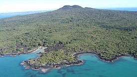
cone capped by central scoria cones, reaching a height of 260 m (850 ft). Rangitoto is the youngest and largest of the approximately 50 volcanoes of the
622:
299:, having erupted in two phases about 1450 CE and 1500 CE and covering an area of 2,311 ha (5,710 acres). It is separated from the mainland of Auckland's
2281:
551:
poison and dogs. The eradication campaign did not have a significant effect on bird species diversity and abundance, due to the presence of other predators.
1461:
1363:
Linnell, Tamzin; et al. (2016). "Long-lived shield volcanism within a monogenetic basaltic field: The conundrum of Rangitoto volcano, New Zealand".
1881:
1166:
776:
2810:
989:
McGee L. 2020. U-Th-Ra analyses of samples from the 2016 drill core of the Rangitoto lava field: Devora report. GNS Science Report 2020/03, 8 p. |url=
2805:
2795:
2187:
1251:
578:
2790:
2780:
2090:
1768:
1335:
2308:
2285:
135:
89:
2785:
2352:
1864:
1826:
1681:
1625:
803:
2770:
1713:
1587:"Bird species diversity and abundance before and after eradication of possums and wallabies on Rangitoto Island, Hauraki Gulf, New Zealand"
1080:"Gravity and magnetic models at Rangitoto Volcano, Auckland Volcanic Field, New Zealand: Implications for basement control on magma ascent"
1736:
1480:; Kenny, Jill A (2022). "Microfossil evidence for a possible maar crater and tuff ring beneath Rangitoto Volcano, Auckland, New Zealand".
1215:
1436:
517:), which is one of the reasons why the local forests are relatively young and do not yet support a large bird population. However, the
2064:
1988:
962:
1134:
2268:
2162:
1773:
886:(1903 - the bow, framing, iron plating and stern with two propeller shaft housings were visible above the low water mark in 2014).
2765:
2345:
1435:
Hayward, B.W. 2017. Eruption sequence of Rangitoto Volcano, Auckland. Geoscience Society of New Zealand Newsletter 23: 4–10. url=
951:
482:
720:
Rangitoto is associated with many traditional stories and myths. One involves Tiriwa (the namesake of the traditil name for the
1423:
Hayward, B.W.; Grenfell, H.R. 2013. Did Rangitoto erupt many times? Geoscience Society of New Zealand Newsletter 11: 5–8. url=
923:
An alternative to walking, a land train, coordinated with the ferry sailings, takes visitors to a short way below the summit.
2418:
2039:
2564:
2815:
2522:
2424:
2065:"Screw Steamer DUCHESS built by Mackie & Thomson in 1897 for J. H. Williams. Wellington Harbour Ferries Ltd., Ferry"
2775:
2213:
1462:
https://sites.google.com/site/nznaturalsciences/new-zealand-natural-sciences-journal/archived-issues/volume-17-1990%7C
1398:
1163:
1449:
1424:
2436:
2412:
957:
882:
842:
832:
2743:
2731:
2528:
1912:
1259:
966:
900:
544:
536:
2701:
2693:
1510:
Crossley, P. 2014. Inside Auckland lava caves. New Zealand Speleological Bulletin vol. 11, no. 208, p. 202-206.
1041:
1007:
945:
477:
trees. In total, more than 200 species of trees and flowers thrive on the island, including several species of
300:
710:
2540:
2406:
2368:
1046:
1012:
939:
590:
540:
296:
930:
There are no campsites on the island, though there is camping at Home Bay on the adjacent Motutapu Island.
2430:
1802:
1527:
818:
on the summit. The northern shore of the island was used as a wrecking ground for unwanted ships, and the
781:
574:
375:
1248:
760:
in 1854, very early in New Zealand's colonisation by Europeans, and for many years served as a source of
2587:
1174:
823:
729:
485:. The vegetation pattern was influenced by the more recent eruptions creating lava flow crevices where
1079:
765:
with another road linking the summit to Islington Bay by 1900. For over 30 years (from 1898 to 1930),
2688:
1437:
https://www.researchgate.net/publication/321062566_Eruption_sequence_of_Rangitoto_Volcano_Auckland%7C
1372:
917:
830:
ferry, Duchess, in June 1947. (built 1897 - iron deck framing remained in 2014). Other ships include
662:(tribes). Human footprints have been found between layers of Rangitoto volcanic ash on the adjoining
646:
543:
was introduced in 1931 and again in 1946. Both were eradicated in a campaign from 1990 to 1996 using
474:
411:
30:
This article is about the island in the Hauraki Gulf. For the islands in the Marlborough Sounds, see
2671:
2593:
2394:
1941:
822:
are still visible at low tide. At least 13 ships were wrecked from 1887, the last being the former
721:
2013:
1655:
2659:
2299:
1477:
889:
531:
were present on Rangitoto in large numbers in the mid 19th century and survived until the 1880s.
514:
35:
2454:
1002:
535:
were introduced to Motutapu in 1862 and spread to Rangitoto, but disappeared by the 1980s. The
422:
2617:
2264:
1860:
1822:
1709:
1677:
1621:
1553:
1493:
1212:
1111:
324:
304:
62:
31:
773:
from near the shoreline on the west side of Islington Bay as building material for Auckland.
2466:
2442:
2225:
1740:
1565:
1531:
1485:
1380:
1316:
1101:
1091:
895:
815:
518:
2120:
2665:
2653:
2599:
2388:
2382:
2166:
1886:
1255:
1219:
1170:
713:
name for the three peaks of the island, and was a name given by Taikehu, a captain of the
663:
558:
380:
312:
280:
39:
2629:
2623:
2159:
656:
2477:
1376:
2635:
2570:
2558:
2400:
827:
819:
795:
boat-owners as a refuge, as it is quite sheltered from the prevailing southwest winds.
699:
598:
292:
640:
2759:
2725:
2677:
2534:
2516:
2460:
1701:
1659:
1473:
1320:
1096:
913:
852:
740:, the fire-goddess, they lost their home on the mainland because it was destroyed by
689:
684:
671:
606:
486:
432:
340:
334:
228:
452:
2546:
2510:
2498:
1570:
1276:
799:
725:
683:
literally means "red sky", and is linked to a traditional story of a fight between
387:
347:
308:
284:
1489:
1450:
https://auckland.figshare.com/articles/media/DEVORA_Forum_2018_Collection/12725501
1706:
A Field Guide to Auckland: Exploring the Region's Natural and Historical Heritage
1425:
https://www.researchgate.net/publication/258374103_Did_Rangitoto_erupt_many_times
1336:"Reconstructing Rangitoto volcano from a 150-m-deep drill core (project 14/U684)"
1188:
670:
was the iwi living on Motutapu, and considers both islands their ancestral home.
539:
was introduced to Motutapu in 1873, and was common on Rangitoto by 1912, and the
352:(canoe) and was badly wounded on the island, after having lost a battle with the
2713:
2647:
2605:
2552:
2448:
1763:
1223:
745:
667:
602:
562:
532:
496:
457:
397:
203:
2250:
Rich pickings: Abandoned vessel material reuse on Rangitoto Island, New Zealand
1937:
Rich Pickings: Abandoned Vessel Material Reuse on Rangitoto Island, New Zealand
1036:
2641:
811:
470:
248:
213:
197:
2323:
2310:
2241:
Vegetation colonisation of Rangitoto Island: the role of crevice microclimate
1497:
1115:
150:
137:
2737:
2707:
2504:
2492:
1554:"The eruption history of Rangitoto: reappraisal of a small New Zealand myth"
924:
757:
586:
582:
509:
504:
The island is considered especially significant because all stages from raw
436:
391:
The opening to a lava tube at Rangitoto, partially obstructed by tree growth
253:
2144:"Active and Well in Nature with a Green Prescription: Rangitoto Island, NZ"
1963:
912:
Regular ferry services and island tours by tractor-trailer are provided by
2337:
1586:
990:
291:, New Zealand. The 5.5 km (3.4 mi) wide island is a symmetrical
73:
466:
444:
needed to explore the caves. The longest known cave is about 120 m long.
440:
288:
243:
238:
223:
218:
208:
123:
17:
2611:
741:
737:
694:
548:
258:
233:
1106:
1384:
770:
766:
761:
522:
478:
465:
Because there are virtually no streams on the island, plants rely on
355:
1935:
1535:
596:
As the area is a DOC-administered reserve (in partnership with the
311:, it has been linked by a causeway to the much older, non-volcanic
1078:
Luthfian, Alutsyah; Eccles, Jennifer D.; Miller, Craig A. (2023).
894:
775:
736:' couple, children of the Fire Gods. After quarreling and cursing
733:
639:
554:
495:
451:
421:
386:
374:
2240:
609:), visitors may not take dogs or other animals onto the islands.
2233:
1708:(Revised ed.). Random House New Zealand. pp. 282–283.
1521:
807:
732:
on the west coast, as a show of his strength. Others involve a '
528:
525:, is thought to have lived on the island in pre-European times.
505:
2341:
1130:
Rangitoto: Odd one out. The story of Auckland's largest volcano
659:
655:
The volcano erupted within the historical memory of the local
581:(DOC) aimed to eradicate them beginning with the poisoning of
570:
566:
379:
The thin land bridge link between Rangitoto Island (left) and
362:
814:. The most visited remains of these installations is the old
34:. For the rural community in New Zealand's North Island, see
2290:
2107:
327:
for 'Bloody Sky', with the name coming from the full phrase
2263:. Hayward, B.W.; Auckland University Press, 2019, 335 pp.
927:
trips from the mainland to the island are also available.
744:, god of earthquakes and eruptions, on Mahuika's behalf.
2110:(from the Rangitoto Island Historic Conservation Trust)
625:
The main vent of Rangitoto Island, now totally forested
876:(1899 - part of the keel and frame remained in 2014),
724:, Te Wao Nui o Tiriwa), a chief of the supernatural
2687:
2580:
2485:
2375:
2014:"Waiheke residents come to town NEW ZEALAND HERALD"
188:
174:
166:
129:
119:
114:
52:
1177:. Updated September 2008. Retrieved 29 April 2009.
78:Oblique aerial of Rangitoto Volcano from the south
1859:. Auckland: New Holland Publishers. p. 126.
1695:
1693:
1821:. Bush Jacket Guides. Auckland: The Bush Press.
780:View of Rangitoto Island from Cheltenham Beach,
500:Lava field with path and encroaching vegetation
333:("The days of the bleeding of Tama-te-kapua").
1794:
1792:
1790:
1620:. Auckland Botanical Society. pp. 23–24.
1358:
1356:
1309:Journal of Volcanology and Geothermal Research
1291:
1289:
1187:Ottaway, Jacqueline Crompton (30 April 2004).
1135:"DEVORA Fact Sheet 3 - Rangitoto: Odd One Out"
1084:Journal of Volcanology and Geothermal Research
1073:
1071:
1069:
1067:
1065:
1063:
2353:
1482:New Zealand Journal of Geology and Geophysics
8:
2291:Rangitoto Island Historic Conservation Trust
1641:Rangitoto & Motutapu restoration project
1585:Spurr, Eric B.; Anderson, Sandra H. (2004).
903:. The island is close to the Auckland shore.
47:
1558:Journal of the Royal Society of New Zealand
1334:Shane, Phil; Linnell, Tamzin (March 2015).
985:
983:
704:
678:
469:for moisture. It has the largest forest of
360:
353:
345:
338:
328:
318:
54:
2801:Tourist attractions in the Auckland Region
2360:
2346:
2338:
1676:. Auckland Botanical Society. p. 16.
1656:Rangitoto Island – Unique Volcanic Island
577:remained a problem on the island, but the
46:
1569:
1547:
1545:
1105:
1095:
798:Military installations were built during
1799:"The Hauraki Gulf Marine Park, Part 2".
1003:"Auckland Volcanic Field: Photo Gallery"
948: – Volcanic activity of New Zealand
756:The island was purchased for £15 by the
96:
2243:. University of Auckland Masters thesis
1769:Te Ara: The Encyclopedia of New Zealand
1164:Hauraki Gulf Islands – Rangitoto Island
991:https://shop.gns.cri.nz/sr_2020-03-pdf/
979:
1365:Geological Society of America Bulletin
1031:
1029:
1651:
1649:
1272:
1270:
1268:
1244:
1242:
1240:
1238:
1236:
1234:
1232:
1208:
1206:
1189:"Rangitoto – Auckland's Fragile Icon"
1159:
1157:
1155:
1153:
1151:
942: – Volcanic field in New Zealand
836:(1900 - her stern remained in 2014),
7:
2261:Volcanoes of Auckland: A Field Guide
2180:"Home Bay, Motutapu Island Campsite"
1296:doi=10.1016/j.jvolgeores.2010.07.017
728:people, who uplifted Rangitoto from
706:Ngā Rangi-i-totongia-a Tama-te-kapua
473:trees in the world, as well as many
330:Ngā Rangi-i-totongia-a Tama-te-kapua
56:Ngā Rangi-i-totongia-a Tama-te-kapua
2236:. University of Auckland PhD thesis
2234:The vegetation pattern of Rangitoto
2142:McCormack, Michael (January 2019).
2040:"1931 – Duchess – Discover – STQRY"
1762:Taonui, Rāwiri (10 February 2015).
1674:Natural History of Rangitoto Island
1672:Mike D Wilcox; et al. (2007).
1618:Natural History of Rangitoto Island
1616:Mike D Wilcox; et al. (2007).
1523:The vegetation pattern of Rangitoto
1399:"Officials downplay volcano danger"
481:, as well as more than 40 types of
2149:. Activity and Nutrition Aotearoa.
1882:"Drunks Bay proves a fateful spot"
38:. For the mountain and range, see
25:
1774:Ministry for Culture and Heritage
426:View from inside one of the caves
2811:Volcanoes of the Auckland Region
2476:
1857:Exploring North Island Volcanoes
1845:. Auckland: Random House. p 228.
1730:Māngere-Ōtāhuhu Area Plan Update
1321:10.1016/j.jvolgeores.2013.03.026
1222:(from the Rangitoto page on the
1097:10.1016/j.jvolgeores.2023.107824
952:List of volcanoes in New Zealand
614:
95:
88:
72:
2806:Volcanic islands of New Zealand
2796:Shield volcanoes of New Zealand
2296:Photographs of Rangitoto Island
2282:Rangitoto Island Scenic Reserve
2169:(Day Trips to Rangitoto Island)
1880:Gray, Matthew (23 March 2010).
1281:New Zealand National Geographic
674:also has links with Rangitoto.
2791:Protected areas of New Zealand
2781:Islands of the Auckland Region
1591:New Zealand Journal of Ecology
1571:10.1080/03036758.1992.10426554
1552:Nichol, Reg (September 1992).
1:
2714:Pupuke Moana / Pupuke Volcano
1843:Auckland: a pictorial history
1643:, Department of Conservation.
1490:10.1080/00288306.2022.2120505
1213:What happened to local Maori?
785:
2786:Monogenetic shield volcanoes
2425:Maungakiekie / One Tree Hill
1989:"New Zealand Maritime Index"
1909:"Rangitoto Ships' Graveyard"
383:is visible here from the air
2771:Islands of the Hauraki Gulf
2212:Jamieson, Alastair (2004).
2108:Welcome to Rangitoto Island
1737:Māngere-Ōtāhuhu Local Board
752:Since European colonisation
2832:
2286:Department of Conservation
2188:Department of Conservation
1993:www.nzmaritimeindex.org.nz
1704:; Murdoch, Graeme (2008).
579:Department of Conservation
367:(tribe) at Islington Bay.
29:
2474:
2018:paperspast.natlib.govt.nz
1964:"Shipwrecks on Rangitoto"
1913:Auckland Regional Council
1855:Glenys Robertson (2005).
1260:Auckland Regional Council
820:remains of several wrecks
804:Auckland harbour defences
537:brush-tailed rock-wallaby
354:
339:
193:
179:
83:
71:
2565:Ōtāhuhu / Mount Richmond
2324:36.786742°S 174.860115°E
2165:10 November 2012 at the
2160:Kayak Trips to Rangitoto
1341:. University of Auckland
1169:25 December 2010 at the
1042:Global Volcanism Program
1008:Global Volcanism Program
946:Volcanism of New Zealand
591:North Island saddlebacks
521:, a New Zealand-endemic
170:260 m (850 ft)
151:36.786742°S 174.860115°E
2766:Auckland volcanic field
2505:Whakamuhu / Glover Park
2437:Ōwairaka / Mount Albert
2413:Ōhinerau / Mount Hobson
2407:Maungawhau / Mount Eden
2369:Auckland volcanic field
2239:Whiting, Diana (1986).
2232:Julian, Andrea (1992).
1662:ferry operator website)
1520:Julian, Andrea (1992).
1279:(abridged article from
1132:. Devora Fact Sheet 03.
1047:Smithsonian Institution
1013:Smithsonian Institution
940:Auckland volcanic field
337:was the captain of the
297:Auckland volcanic field
2329:-36.786742; 174.860115
2256:. Flinders University.
2247:Bennett, Kurt (2014).
2218:New Zealand Geographic
2089:Bennett, Kurt (2014).
1803:The New Zealand Herald
1528:University of Auckland
1218:5 October 2003 at the
904:
791:
705:
679:
652:
501:
462:
427:
392:
384:
361:
346:
329:
319:
189:Additional information
156:-36.786742; 174.860115
55:
2302:heritage collections.
1175:Auckland City Council
969:set around Rangitoto.
898:
779:
643:
499:
455:
425:
390:
378:
27:Island in New Zealand
2816:Lookouts in Auckland
2069:www.clydeships.co.uk
1476:; Hopkins, Jenni L;
918:Auckland city centre
858:Countess of Anglesea
647:Pteridium esculentum
461:growing on Rangitoto
412:Rangitoto Lighthouse
2594:Boggust Park Crater
2431:Te Tātua a Riukiuta
2395:Albert Park Volcano
2320: /
2300:Auckland Libraries'
1942:Flinders University
1817:Gordon Ell (1980).
1377:2016GSAB..128.1160L
1254:20 May 2008 at the
147: /
49:
2776:Island restoration
2121:"Rangitoto Island"
2044:discover.stqry.com
1841:Wolfe, R. (2002).
1371:(7–8): 1160–1172.
958:Under the Mountain
908:Access and tourism
905:
792:
711:Ngāi Tai ki Tāmaki
653:
515:primary succession
502:
463:
428:
393:
385:
167:Highest point
36:Rangitoto, Waikato
2753:
2752:
2689:Waitematā Harbour
1968:www.rangitoto.org
1866:978-1-86966-078-9
1828:978-0-908608-04-1
1683:978-0-9583447-3-9
1627:978-0-9583447-3-9
697:, captain of the
687:, captain of the
636:Māori association
305:Rangitoto Channel
274:
273:
32:Rangitoto Islands
16:(Redirected from
2823:
2672:Māngere Mountain
2480:
2467:Little Rangitoto
2443:Te Hopua a Rangi
2419:Mount Saint John
2383:Pukekawa Volcano
2376:Central Auckland
2362:
2355:
2348:
2339:
2335:
2334:
2332:
2331:
2330:
2325:
2321:
2318:
2317:
2316:
2313:
2257:
2255:
2229:
2228:on 11 June 2016.
2224:. Archived from
2199:
2198:
2196:
2194:
2176:
2170:
2157:
2151:
2150:
2148:
2139:
2133:
2132:
2130:
2128:
2117:
2111:
2105:
2099:
2098:
2086:
2080:
2079:
2077:
2075:
2061:
2055:
2054:
2052:
2050:
2036:
2030:
2029:
2027:
2025:
2020:. 9 January 1932
2010:
2004:
2003:
2001:
1999:
1985:
1979:
1978:
1976:
1974:
1960:
1954:
1953:
1951:
1949:
1931:
1925:
1924:
1922:
1920:
1905:
1899:
1898:
1896:
1894:
1877:
1871:
1870:
1852:
1846:
1839:
1833:
1832:
1814:
1808:
1807:
1796:
1785:
1784:
1782:
1780:
1759:
1753:
1752:
1750:
1748:
1743:. September 2022
1741:Auckland Council
1734:
1726:
1720:
1719:
1715:978-1-86962-1513
1697:
1688:
1687:
1669:
1663:
1653:
1644:
1638:
1632:
1631:
1613:
1607:
1606:
1604:
1602:
1582:
1576:
1575:
1573:
1549:
1540:
1539:
1517:
1511:
1508:
1502:
1501:
1478:Morley, Margaret
1474:Hayward, Bruce W
1470:
1464:
1458:
1452:
1445:
1439:
1433:
1427:
1421:
1415:
1414:
1412:
1410:
1395:
1389:
1388:
1385:10.1130/B31392.1
1360:
1351:
1350:
1348:
1346:
1340:
1331:
1325:
1324:
1303:
1297:
1293:
1284:
1274:
1263:
1246:
1227:
1210:
1201:
1200:
1198:
1196:
1184:
1178:
1161:
1146:
1145:
1143:
1141:
1126:
1120:
1119:
1109:
1099:
1075:
1058:
1057:
1055:
1053:
1037:"Auckland Field"
1033:
1024:
1023:
1021:
1019:
999:
993:
987:
816:observation post
810:troops or store
790:
787:
722:Waitākere Ranges
708:
703:canoe. The name
682:
651:Rangitoto Island
618:
541:brushtail possum
405:Eruptive history
366:
359:
358:
351:
344:
343:
332:
322:
277:Rangitoto Island
270:
200:
162:
161:
159:
158:
157:
152:
148:
145:
144:
143:
140:
103:Rangitoto Island
99:
98:
92:
76:
66:
58:
50:
48:Rangitoto Island
21:
2831:
2830:
2826:
2825:
2824:
2822:
2821:
2820:
2756:
2755:
2754:
2749:
2691:
2683:
2666:Puketutu Island
2654:Puhinui Craters
2600:Cemetery Crater
2576:
2523:Pigeon Mountain
2481:
2472:
2389:Grafton Volcano
2371:
2366:
2328:
2326:
2322:
2319:
2314:
2311:
2309:
2307:
2306:
2278:
2253:
2246:
2211:
2208:
2206:Further reading
2203:
2202:
2192:
2190:
2184:www.doc.govt.nz
2178:
2177:
2173:
2167:Wayback Machine
2158:
2154:
2146:
2141:
2140:
2136:
2126:
2124:
2123:. Fullers Group
2119:
2118:
2114:
2106:
2102:
2091:"Rich Pickings"
2088:
2087:
2083:
2073:
2071:
2063:
2062:
2058:
2048:
2046:
2038:
2037:
2033:
2023:
2021:
2012:
2011:
2007:
1997:
1995:
1987:
1986:
1982:
1972:
1970:
1962:
1961:
1957:
1947:
1945:
1934:Bennett, Kurt.
1933:
1932:
1928:
1918:
1916:
1907:
1906:
1902:
1892:
1890:
1879:
1878:
1874:
1867:
1854:
1853:
1849:
1840:
1836:
1829:
1816:
1815:
1811:
1806:. 2 March 2010.
1798:
1797:
1788:
1778:
1776:
1764:"Tāmaki tribes"
1761:
1760:
1756:
1746:
1744:
1732:
1728:
1727:
1723:
1716:
1700:Cameron, Ewen;
1699:
1698:
1691:
1684:
1671:
1670:
1666:
1654:
1647:
1639:
1635:
1628:
1615:
1614:
1610:
1600:
1598:
1584:
1583:
1579:
1564:(3): 159–180 .
1551:
1550:
1543:
1519:
1518:
1514:
1509:
1505:
1472:
1471:
1467:
1459:
1455:
1446:
1442:
1434:
1430:
1422:
1418:
1408:
1406:
1405:. 12 April 2013
1397:
1396:
1392:
1362:
1361:
1354:
1344:
1342:
1338:
1333:
1332:
1328:
1305:
1304:
1300:
1294:
1287:
1275:
1266:
1256:Wayback Machine
1247:
1230:
1220:Wayback Machine
1211:
1204:
1194:
1192:
1186:
1185:
1181:
1171:Wayback Machine
1162:
1149:
1139:
1137:
1133:
1128:Devora (2020).
1127:
1123:
1077:
1076:
1061:
1051:
1049:
1035:
1034:
1027:
1017:
1015:
1001:
1000:
996:
988:
981:
976:
936:
910:
802:to support the
788:
754:
664:Motutapu Island
638:
633:
628:
627:
626:
624:
619:
450:
420:
407:
381:Motutapu Island
373:
313:Motutapu Island
281:volcanic island
269:
268:
267:
266:
261:
256:
251:
246:
241:
236:
231:
226:
221:
216:
211:
206:
195:
194:
184:
155:
153:
149:
146:
141:
138:
136:
134:
133:
110:
109:
108:
107:
106:
105:
104:
100:
79:
67:
60:
43:
40:Rangitoto Range
28:
23:
22:
15:
12:
11:
5:
2829:
2827:
2819:
2818:
2813:
2808:
2803:
2798:
2793:
2788:
2783:
2778:
2773:
2768:
2758:
2757:
2751:
2750:
2748:
2747:
2741:
2735:
2732:Mount Victoria
2729:
2723:
2717:
2711:
2705:
2698:
2696:
2685:
2684:
2682:
2681:
2675:
2669:
2663:
2657:
2651:
2645:
2639:
2636:Maungataketake
2633:
2627:
2621:
2618:Māngere Lagoon
2615:
2609:
2603:
2597:
2591:
2584:
2582:
2581:South Auckland
2578:
2577:
2575:
2574:
2571:Robertson Hill
2568:
2562:
2559:McLennan Hills
2556:
2550:
2544:
2538:
2532:
2526:
2520:
2514:
2508:
2502:
2496:
2489:
2487:
2483:
2482:
2475:
2473:
2471:
2470:
2464:
2458:
2452:
2446:
2440:
2434:
2428:
2422:
2416:
2410:
2404:
2401:Te Pou Hawaiki
2398:
2392:
2386:
2379:
2377:
2373:
2372:
2367:
2365:
2364:
2357:
2350:
2342:
2304:
2303:
2293:
2288:
2277:
2276:External links
2274:
2273:
2272:
2258:
2244:
2237:
2230:
2207:
2204:
2201:
2200:
2171:
2152:
2134:
2112:
2100:
2081:
2056:
2031:
2005:
1980:
1955:
1926:
1900:
1872:
1865:
1847:
1834:
1827:
1809:
1786:
1754:
1721:
1714:
1702:Hayward, Bruce
1689:
1682:
1664:
1645:
1633:
1626:
1608:
1577:
1541:
1526:(PhD thesis).
1512:
1503:
1465:
1453:
1440:
1428:
1416:
1390:
1352:
1326:
1298:
1285:
1264:
1228:
1202:
1179:
1147:
1121:
1059:
1025:
994:
978:
977:
975:
972:
971:
970:
954:
949:
943:
935:
932:
909:
906:
901:Mount Victoria
753:
750:
644:Bracken fern,
637:
634:
632:
629:
621:
620:
613:
612:
611:
599:tangata whenua
449:
446:
419:
416:
406:
403:
372:
369:
293:shield volcano
272:
271:
264:
263:
262:
257:
252:
247:
242:
237:
232:
227:
222:
217:
212:
207:
202:
201:
191:
190:
186:
185:
180:
177:
176:
175:Administration
172:
171:
168:
164:
163:
131:
127:
126:
121:
117:
116:
112:
111:
102:
101:
94:
93:
87:
86:
85:
84:
81:
80:
77:
69:
68:
53:
26:
24:
14:
13:
10:
9:
6:
4:
3:
2:
2828:
2817:
2814:
2812:
2809:
2807:
2804:
2802:
2799:
2797:
2794:
2792:
2789:
2787:
2784:
2782:
2779:
2777:
2774:
2772:
2769:
2767:
2764:
2763:
2761:
2745:
2742:
2739:
2736:
2733:
2730:
2727:
2726:Mount Cambria
2724:
2721:
2718:
2715:
2712:
2709:
2706:
2703:
2700:
2699:
2697:
2695:
2690:
2686:
2679:
2678:Pukaki Lagoon
2676:
2673:
2670:
2667:
2664:
2661:
2658:
2655:
2652:
2649:
2646:
2643:
2640:
2637:
2634:
2631:
2628:
2625:
2622:
2619:
2616:
2613:
2610:
2607:
2604:
2601:
2598:
2595:
2592:
2589:
2586:
2585:
2583:
2579:
2572:
2569:
2566:
2563:
2560:
2557:
2554:
2551:
2548:
2545:
2542:
2539:
2536:
2533:
2530:
2527:
2524:
2521:
2518:
2517:Panmure Basin
2515:
2512:
2509:
2506:
2503:
2500:
2497:
2494:
2491:
2490:
2488:
2486:East Auckland
2484:
2479:
2468:
2465:
2462:
2459:
2456:
2453:
2450:
2447:
2444:
2441:
2438:
2435:
2432:
2429:
2426:
2423:
2420:
2417:
2414:
2411:
2408:
2405:
2402:
2399:
2396:
2393:
2390:
2387:
2384:
2381:
2380:
2378:
2374:
2370:
2363:
2358:
2356:
2351:
2349:
2344:
2343:
2340:
2336:
2333:
2301:
2297:
2294:
2292:
2289:
2287:
2283:
2280:
2279:
2275:
2270:
2269:0-582-71784-1
2266:
2262:
2259:
2252:
2251:
2245:
2242:
2238:
2235:
2231:
2227:
2223:
2219:
2215:
2210:
2209:
2205:
2189:
2185:
2181:
2175:
2172:
2168:
2164:
2161:
2156:
2153:
2145:
2138:
2135:
2122:
2116:
2113:
2109:
2104:
2101:
2096:
2092:
2085:
2082:
2070:
2066:
2060:
2057:
2045:
2041:
2035:
2032:
2019:
2015:
2009:
2006:
1994:
1990:
1984:
1981:
1969:
1965:
1959:
1956:
1943:
1939:
1938:
1930:
1927:
1914:
1910:
1904:
1901:
1889:
1888:
1883:
1876:
1873:
1868:
1862:
1858:
1851:
1848:
1844:
1838:
1835:
1830:
1824:
1820:
1813:
1810:
1805:
1804:
1795:
1793:
1791:
1787:
1775:
1771:
1770:
1765:
1758:
1755:
1742:
1738:
1731:
1725:
1722:
1717:
1711:
1707:
1703:
1696:
1694:
1690:
1685:
1679:
1675:
1668:
1665:
1661:
1657:
1652:
1650:
1646:
1642:
1637:
1634:
1629:
1623:
1619:
1612:
1609:
1596:
1592:
1588:
1581:
1578:
1572:
1567:
1563:
1559:
1555:
1548:
1546:
1542:
1537:
1533:
1529:
1525:
1524:
1516:
1513:
1507:
1504:
1499:
1495:
1491:
1487:
1483:
1479:
1475:
1469:
1466:
1463:
1457:
1454:
1451:
1444:
1441:
1438:
1432:
1429:
1426:
1420:
1417:
1404:
1400:
1394:
1391:
1386:
1382:
1378:
1374:
1370:
1366:
1359:
1357:
1353:
1337:
1330:
1327:
1322:
1318:
1314:
1310:
1302:
1299:
1292:
1290:
1286:
1282:
1278:
1273:
1271:
1269:
1265:
1261:
1257:
1253:
1250:
1245:
1243:
1241:
1239:
1237:
1235:
1233:
1229:
1225:
1221:
1217:
1214:
1209:
1207:
1203:
1190:
1183:
1180:
1176:
1172:
1168:
1165:
1160:
1158:
1156:
1154:
1152:
1148:
1136:
1131:
1125:
1122:
1117:
1113:
1108:
1103:
1098:
1093:
1089:
1085:
1081:
1074:
1072:
1070:
1068:
1066:
1064:
1060:
1048:
1044:
1043:
1038:
1032:
1030:
1026:
1014:
1010:
1009:
1004:
998:
995:
992:
986:
984:
980:
973:
968:
964:
960:
959:
955:
953:
950:
947:
944:
941:
938:
937:
933:
931:
928:
926:
921:
919:
915:
907:
902:
897:
893:
891:
887:
885:
884:
879:
875:
871:
867:
863:
862:Elinor Vernon
859:
855:
854:
849:
845:
844:
839:
835:
834:
829:
825:
821:
817:
813:
809:
806:and to house
805:
801:
796:
783:
778:
774:
772:
768:
763:
759:
751:
749:
747:
743:
739:
735:
731:
727:
723:
718:
716:
712:
707:
702:
701:
696:
692:
691:
686:
685:Tama-te-kapua
681:
675:
673:
669:
665:
661:
658:
650:
648:
642:
635:
630:
623:
617:
610:
608:
604:
601:
600:
594:
592:
588:
584:
580:
576:
572:
568:
564:
560:
556:
552:
550:
546:
542:
538:
534:
530:
526:
524:
520:
516:
511:
507:
498:
494:
492:
488:
484:
480:
476:
475:northern rātā
472:
468:
460:
459:
454:
447:
445:
442:
438:
434:
424:
417:
415:
413:
404:
402:
399:
389:
382:
377:
370:
368:
365:
364:
357:
350:
349:
342:
336:
335:Tama-te-kapua
331:
326:
321:
316:
314:
310:
306:
302:
298:
294:
290:
286:
282:
278:
260:
255:
250:
245:
240:
235:
230:
225:
220:
215:
210:
205:
199:
192:
187:
183:
178:
173:
169:
165:
160:
132:
128:
125:
122:
118:
113:
91:
82:
75:
70:
64:
57:
51:
45:
41:
37:
33:
19:
2719:
2630:Matukutūruru
2624:Matukutūreia
2547:Styaks Swamp
2529:Hampton Park
2511:Taylors Hill
2499:Purchas Hill
2455:Ōrākei Basin
2305:
2260:
2249:
2226:the original
2221:
2217:
2191:. Retrieved
2183:
2174:
2155:
2137:
2125:. Retrieved
2115:
2103:
2094:
2084:
2072:. Retrieved
2068:
2059:
2047:. Retrieved
2043:
2034:
2022:. Retrieved
2017:
2008:
1996:. Retrieved
1992:
1983:
1971:. Retrieved
1967:
1958:
1946:. Retrieved
1936:
1929:
1917:. Retrieved
1903:
1891:. Retrieved
1885:
1875:
1856:
1850:
1842:
1837:
1818:
1812:
1800:
1779:15 September
1777:. Retrieved
1767:
1757:
1745:. Retrieved
1724:
1705:
1673:
1667:
1636:
1617:
1611:
1599:. Retrieved
1597:(1): 143–149
1594:
1590:
1580:
1561:
1557:
1522:
1515:
1506:
1481:
1468:
1456:
1443:
1431:
1419:
1407:. Retrieved
1402:
1393:
1368:
1364:
1343:. Retrieved
1329:
1312:
1308:
1301:
1280:
1193:. Retrieved
1182:
1138:. Retrieved
1129:
1124:
1087:
1083:
1050:. Retrieved
1040:
1016:. Retrieved
1006:
997:
961:is a novel,
956:
929:
922:
911:
899:Viewed from
888:
881:
877:
873:
869:
865:
861:
857:
851:
848:Rothesay Bay
847:
841:
837:
831:
826:and, later,
800:World War II
797:
793:
755:
719:
714:
698:
688:
676:
654:
645:
597:
595:
553:
527:
503:
493:ssp.) grow.
491:Metrosideros
490:
464:
456:
429:
408:
394:
317:
309:World War II
285:Hauraki Gulf
276:
275:
181:
44:
2694:North Shore
2606:Crater Hill
2553:Pukewairiki
2449:Mount Smart
2327: /
2315:174°51′36″E
2214:"Rangitoto"
1315:: 174–183.
1224:GNS Science
880:(1877) and
789: 1908
746:Lake Pupuke
693:canoe, and
533:Fallow deer
458:Pterostylis
398:scoria cone
301:North Shore
182:New Zealand
154: /
142:174°51′36″E
130:Coordinates
2760:Categories
2702:Maungauika
2642:Waitomokia
2541:Green Hill
2535:Ōtara Hill
2461:Puketāpapa
2312:36°47′12″S
2074:22 January
1948:6 February
1940:(Thesis).
1735:(Report).
1658:(from the
1258:(from the
1107:2292/65385
1090:(107824).
974:References
824:Wellington
672:Ngāti Paoa
607:Ngāti Paoa
587:brown rats
583:black rats
508:fields to
487:pōhutukawa
471:pohutukawa
437:lava tubes
198:Meghalayan
139:36°47′12″S
2738:Tank Farm
2720:Rangitoto
2708:Motukorea
2493:Maungarei
1819:Rangitoto
1801:Inset to
1498:0028-8306
1403:3 News NZ
1345:6 October
1277:Rangitoto
1249:Rangitoto
1116:0377-0273
963:TV series
925:Sea kayak
853:Gladbrook
782:Devonport
680:Rangitoto
677:The name
575:hedgehogs
418:Structure
320:Rangitoto
115:Geography
18:Rangitoto
2648:Ōtuataua
2588:Ash Hill
2298:held in
2193:30 March
2163:Archived
2095:Academia
1893:30 March
1601:30 March
1484:: 1–17.
1262:website)
1252:Archived
1226:website)
1216:Archived
1195:26 April
1167:Archived
1052:29 April
934:See also
878:Dartford
874:Columbia
870:Skovland
864:(1876),
850:(1877),
846:(1908),
840:(1857),
771:quarried
730:Karekare
668:Ngāi Tai
603:Ngāi Tai
467:rainfall
441:pahoehoe
307:. Since
289:Auckland
124:Auckland
120:Location
2744:Onepoto
2660:Pukeiti
2612:Kohuora
2284:at the
2049:18 July
2024:18 July
1998:18 July
1973:18 July
1944:website
1915:website
1660:Fullers
1536:2292/27
1409:9 April
1373:Bibcode
1191:. NZine
1140:3 March
1018:21 June
914:Fullers
872:1891),
860:1877),
843:Arapawa
838:Jubilee
833:Ngapuhi
828:Waiheke
742:Mataoho
738:Mahuika
717:canoe.
695:Hoturoa
631:History
559:rabbits
549:cyanide
489:trees (
448:Biology
433:clinker
371:Geology
303:by the
283:in the
265:↓
2267:
2127:31 May
1919:8 June
1863:
1825:
1712:
1680:
1624:
1496:
1114:
890:Baches
883:Rarawa
767:scoria
762:basalt
726:Tūrehu
715:Tainui
700:Tainui
555:Stoats
523:parrot
479:orchid
356:Tainui
59:
2254:(PDF)
2147:(PDF)
1887:Stuff
1747:1 May
1733:(PDF)
1339:(PDF)
916:from
866:Polly
812:mines
758:Crown
734:tupua
690:Arawa
657:Māori
529:Goats
510:scrub
483:ferns
341:Arawa
325:Māori
287:near
279:is a
63:Māori
2692:and
2680:(44)
2674:(37)
2668:(39)
2662:(41)
2656:(53)
2650:(42)
2644:(40)
2638:(43)
2632:(48)
2626:(47)
2620:(38)
2614:(46)
2608:(45)
2602:(52)
2596:(51)
2590:(49)
2573:(30)
2567:(28)
2561:(29)
2555:(31)
2549:(35)
2543:(34)
2537:(33)
2531:(32)
2525:(36)
2519:(25)
2513:(22)
2507:(21)
2501:(23)
2495:(24)
2469:(19)
2463:(14)
2457:(20)
2451:(26)
2445:(27)
2439:(13)
2433:(15)
2427:(16)
2421:(17)
2415:(18)
2409:(11)
2403:(12)
2391:(50)
2385:(10)
2265:ISBN
2195:2020
2129:2019
2076:2024
2051:2019
2026:2019
2000:2019
1975:2019
1950:2016
1921:2008
1895:2020
1861:ISBN
1823:ISBN
1781:2016
1749:2023
1710:ISBN
1678:ISBN
1622:ISBN
1603:2020
1494:ISSN
1448:url=
1411:2016
1347:2015
1197:2010
1142:2023
1112:ISSN
1054:2009
1020:2008
967:film
965:and
868:(ex
856:(ex
808:U.S.
769:was
605:and
573:and
571:cats
567:rats
563:mice
547:and
545:1080
519:Kākā
506:lava
348:waka
204:PreꞒ
196:Age
2746:(3)
2740:(2)
2734:(4)
2728:(5)
2722:(7)
2716:(1)
2710:(8)
2704:(6)
2397:(9)
1566:doi
1532:hdl
1486:doi
1381:doi
1369:128
1317:doi
1313:257
1102:hdl
1092:doi
1088:439
660:iwi
363:iwi
323:is
2762::
2222:68
2220:.
2216:.
2186:.
2182:.
2093:.
2067:.
2042:.
2016:.
1991:.
1966:.
1911:.
1884:.
1789:^
1772:.
1766:.
1739:,
1692:^
1648:^
1595:28
1593:.
1589:.
1562:22
1560:.
1556:.
1544:^
1530:.
1492:.
1401:.
1379:.
1367:.
1355:^
1311:.
1288:^
1267:^
1231:^
1205:^
1173:,
1150:^
1110:.
1100:.
1086:.
1082:.
1062:^
1045:.
1039:.
1028:^
1011:.
1005:.
982:^
786:c.
784:,
666:.
593:.
585:,
569:,
565:,
561:,
557:,
315:.
254:Pg
2361:e
2354:t
2347:v
2271:.
2197:.
2131:.
2097:.
2078:.
2053:.
2028:.
2002:.
1977:.
1952:.
1923:.
1897:.
1869:.
1831:.
1783:.
1751:.
1718:.
1686:.
1630:.
1605:.
1574:.
1568::
1538:.
1534::
1500:.
1488::
1413:.
1387:.
1383::
1375::
1349:.
1323:.
1319::
1283:)
1199:.
1144:.
1118:.
1104::
1094::
1056:.
1022:.
649:,
259:N
249:K
244:J
239:T
234:P
229:C
224:D
219:S
214:O
209:Ꞓ
65:)
61:(
42:.
20:)
Text is available under the Creative Commons Attribution-ShareAlike License. Additional terms may apply.