400:
376:
67:
50:
388:
100:
173:
211:
38:
192:
507:
107:
74:
336:
A memorable moment was known with the progression of the second world war. In the war waged village, Jewish refugees were actively hidden in the town's school attic. The school principal stimulated this and supplied the refugees with food and water. As it was found out, the principal and the Jewish
332:
Ravenswoud was founded as a peat-cutter settlement in 1850. Having this origin, the owners of the peat-rich earth hired workers to undo the soil of peat. In 1871 the first house was built and the first petition for a school came in 1881. After the first world war the population increased due to the
333:
building of houses by the local housing association. By relocating typically a-social families to here, the village got a bad reputation. Their decrepit houses were demolished around 1949 and the land was sold to the government or private buyers.
399:
544:
537:
676:
49:
530:
66:
375:
203:
264:
37:
700:
695:
337:
refugees were executed instantly. This act of resistance has been commemorated by renaming the street he lived in and the school he taught.
276:
99:
135:
554:
482:
387:
184:
350:
522:
572:
511:
301:
354:
598:
558:
313:
215:
210:
486:
359:
479:
429:
689:
664:
633:
628:
593:
321:
177:
172:
618:
613:
150:
137:
643:
603:
588:
346:
317:
196:
191:
506:
623:
659:
309:
364:. It is one of the best preserved highland areas in the Netherlands.
608:
454:
526:
42:
View over
Fochteloërveen from the watchtower near Ravenswoud
517:
312:
consisting of about 400 inhabitants in the municipality of
289:
652:
581:
565:
285:
275:
263:
255:
247:
242:
234:
226:
221:
202:
183:
166:
21:
677:List of cities, towns and villages in Friesland
538:
8:
545:
531:
523:
345:There is a nature reserve located between
18:
54:Location in Ooststellingwerf municipality
416:
371:
284:
262:
241:
233:
220:
165:
130:
58:
46:
34:
424:
422:
420:
274:
254:
246:
225:
201:
182:
7:
430:"Kerncijfers wijken en buurten 2021"
230:12.97 km (5.01 sq mi)
106:
73:
14:
16:Village in Friesland, Netherlands
505:
489:- Ooststellingwerf Municipality
398:
386:
374:
209:
190:
171:
105:
98:
72:
65:
48:
36:
461:(in Dutch). Het Waterschapshuis
459:Actueel Hoogtebestand Nederland
518:Official website of Ravenswoud
1:
701:Populated places in Friesland
696:Geography of Ooststellingwerf
434:Central Bureau of Statistics
86:Location in the Netherlands
717:
674:
455:"Postcodetool for 8427RC"
131:
59:
47:
35:
28:
553:Populated places in the
119:Ravenswoud (Netherlands)
122:Show map of Netherlands
305:
238:10 m (30 ft)
381:Observation tower "7"
259:31/km (81/sq mi)
89:Show map of Friesland
514:at Wikimedia Commons
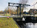
393:Bridge in Ravenswoud
256: • Density
151:52.96444°N 6.38028°E
147: /
485:2017-09-28 at the
248: • Total
227: • Total
683:
682:
510:Media related to
349:, Ravenswoud and
295:
294:
156:52.96444; 6.38028
708:
559:Ooststellingwerf
547:
540:
533:
524:
509:
493:
492:
477:
471:
470:
468:
466:
451:
445:
444:
442:
440:
426:
402:
390:
378:
363:
314:Ooststellingwerf
290:Official website
216:Ooststellingwerf
214:
213:
195:
194:
176:
175:
162:
161:
159:
158:
157:
152:
148:
145:
144:
143:
140:
123:
109:
108:
102:
90:
76:
75:
69:
52:
40:
19:
716:
715:
711:
710:
709:
707:
706:
705:
686:
685:
684:
679:
670:
648:
577:
561:
551:
502:
497:
496:
490:
487:Wayback Machine
478:
474:
464:
462:
453:
452:
448:
438:
436:
428:
427:
418:
413:
406:
403:
394:
391:
382:
379:
370:
357:
343:
330:
316:in the east of
271:
208:
189:
170:
155:
153:
149:
146:
141:
138:
136:
134:
133:
127:
126:
125:
124:
121:
120:
117:
116:
115:
114:
110:
93:
92:
91:
88:
87:
84:
83:
82:
81:
77:
55:
43:
31:
24:
17:
12:
11:
5:
714:
712:
704:
703:
698:
688:
687:
681:
680:
675:
672:
671:
669:
668:
662:
656:
654:
650:
649:
647:
646:
641:
636:
631:
626:
621:
616:
611:
606:
601:
596:
591:
585:
583:
579:
578:
576:
575:
569:
567:
563:
562:
552:
550:
549:
542:
535:
527:
521:
520:
515:
501:
500:External links
498:
495:
494:
472:
446:
415:
414:
412:
409:
408:
407:
404:
397:
395:
392:
385:
383:
380:
373:
369:
366:
355:Fochteloërveen
342:
339:
329:
326:
293:
292:
287:
283:
282:
279:
273:
272:
269:
267:
261:
260:
257:
253:
252:
249:
245:
244:
240:
239:
236:
232:
231:
228:
224:
223:
219:
218:
206:
200:
199:
187:
181:
180:
168:
164:
163:
129:
128:
118:
112:
111:
104:
103:
97:
96:
95:
94:
85:
79:
78:
71:
70:
64:
63:
62:
61:
60:
57:
56:
53:
45:
44:
41:
33:
32:
29:
26:
25:
22:
15:
13:
10:
9:
6:
4:
3:
2:
713:
702:
699:
697:
694:
693:
691:
678:
673:
666:
663:
661:
658:
657:
655:
651:
645:
642:
640:
637:
635:
632:
630:
627:
625:
622:
620:
617:
615:
612:
610:
607:
605:
602:
600:
597:
595:
592:
590:
587:
586:
584:
580:
574:
571:
570:
568:
564:
560:
556:
548:
543:
541:
536:
534:
529:
528:
525:
519:
516:
513:
508:
504:
503:
499:
488:
484:
481:
476:
473:
460:
456:
450:
447:
435:
431:
425:
423:
421:
417:
410:
405:Campagnonsbos
401:
396:
389:
384:
377:
372:
367:
365:
361:
356:
352:
348:
340:
338:
334:
327:
325:
323:
319:
315:
311:
307:
303:
299:
291:
288:
280:
278:
268:
266:
258:
250:
237:
229:
217:
212:
207:
205:
198:
193:
188:
186:
179:
174:
169:
160:
132:Coordinates:
101:
68:
51:
39:
27:
20:
638:
555:municipality
475:
463:. Retrieved
458:
449:
437:. Retrieved
433:
344:
335:
331:
302:West Frisian
297:
296:
277:Dialing code
204:Municipality
667:(partially)
665:Oude Willem
634:Oldeberkoop
629:Nijeberkoop
594:Donkerbroek
573:Oosterwolde
358: [
322:Netherlands
265:Postal code
178:Netherlands
154: /
690:Categories
639:Ravenswoud
619:Langedijke
614:Haulerwijk
512:Ravenswoud
491:(in Dutch)
411:References
351:Veenhuizen
306:Ravenswâld
298:Ravenswoud
243:Population
139:52°57′52″N
113:Ravenswoud
80:Ravenswoud
23:Ravenswoud
644:Waskemeer
604:Fochteloo
589:Appelscha
353:, called
347:Fochteloo
341:Geography
318:Friesland
235:Elevation
197:Friesland
142:6°22′49″E
624:Makkinga
582:Villages
483:Archived
480:Villages
185:Province
660:Aekinga
653:Hamlets
465:1 April
439:1 April
368:Gallery
328:History
310:village
308:) is a
286:Website
167:Country
30:Village
599:Elsloo
320:, the
609:Haule
566:Towns
362:]
467:2022
441:2022
281:0516
270:8427
222:Area
557:of
324:.
251:405
692::
457:.
432:.
419:^
360:nl
304::
546:e
539:t
532:v
469:.
443:.
300:(
Text is available under the Creative Commons Attribution-ShareAlike License. Additional terms may apply.