51:
84:
31:
91:
58:
274:, Little Woody River, Wilson Creek, Homestead Creek, North Shore Creek, and Lost River. The lake's shoreline features several named bays, such as Grassy Bay, Armit River Bay, Ellis Bay, Woody Bay, Long Point Bay, and Lost River Bay. The lake does not have any notable islands.
310:
Today, the area around Red Deer Lake remains heavily forested. Fishing is a common activity, with fisheries in the lake and nearby Dawson Bay processing the catch from Red Deer Lake. Additionally, the region is known for
302:
near the mill on the lakeshore, and
Barrows at the railway junction. The sawmill operated until 1926, after which the area continued to be a hub for other logging companies and smaller sawmills.
134:
50:
236:
83:
270:. In addition to the Red Deer River, the lake is fed by several smaller rivers and creeks, including the Grassy River,
333:
455:
343:
328:
295:
267:
263:
244:
173:
299:
283:
224:
36:
298:
line to the south. To support the mill operations, the company developed two settlements: the community of
180:
422:
338:
316:
282:
The area around Red Deer Lake played a significant role in the local lumber industry. In 1901, the
262:
Geographically, Red Deer Lake is almost entirely within the northwest corner of
Manitoba's Census
166:
252:
248:
364:
398:"Historic Sites of Manitoba: Red Deer Lumber Company and Bank Vault (Northern Manitoba)"
192:
397:
449:
256:
312:
271:
251:
and 16 kilometres (9.9 mi) west of Dawson Bay, which is part of the larger
149:
136:
291:
240:
120:
30:
287:
167:
181:
266:, with its northernmost parts extending into the southwest corner of
198:
247:. It is situated approximately 8 kilometres (5.0 mi) north of
255:. The lake lies about 13 kilometres (8.1 mi) east of the
319:, which adds another layer of economic activity to the area.
235:
is a lake located in the west-central region of the
382:Hudson Bay & District Cultural Society (1982).
220:
216:
208:
204:
191:
179:
165:
126:
115:
23:
437:Mining and mineral prospects in northern Manitoba.
384:Valley Echoes: Life Along the Red Deer River Basin
363:Government of Canada, Natural Resources Canada.
127:
243:. The lake's primary inflow and outflow is the
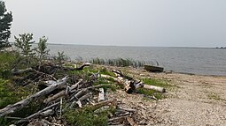
35:Photo taken on the south shore of the lake at
386:. Winnipeg, Manitoba: Inter-Collegiate Press.
8:
290:on the south shore of the lake and built a
20:
355:
90:
57:
7:
14:
89:
82:
70:Location of the lake in Manitoba
56:
49:
29:
435:Robert Charles Wallace (1919).
207:
1:
365:"Place names - Red Deer Lake"
315:, particularly targeting the
114:
423:"Comprehensive Mining Data"
334:Assiniboine River fur trade
294:to connect the mill to the
472:
344:Hudson Bay drainage basin
329:List of lakes of Manitoba
296:Canadian Northern Railway
43:
28:
16:Lake in Manitoba, Canada
284:Red Deer Lumber Company
37:Red Deer Lake, Manitoba
103:Red Deer Lake (Canada)
212:860 feet (260 m)
73:Show map of Manitoba
339:Fort Red Deer River
317:Mannville Formation
146: /
150:52.950°N 101.367°W
106:Show map of Canada
456:Lakes of Manitoba
253:Lake Winnipegosis
237:Canadian province
230:
229:
209:Surface elevation
463:
440:
433:
427:
426:
419:
413:
412:
410:
408:
394:
388:
387:
379:
373:
372:
369:www4.rncan.gc.ca
360:
313:coal exploration
183:
182:Primary outflows
169:
161:
160:
158:
157:
156:
155:52.950; -101.367
151:
147:
144:
143:
142:
139:
129:
107:
93:
92:
86:
74:
60:
59:
53:
33:
21:
471:
470:
466:
465:
464:
462:
461:
460:
446:
445:
444:
443:
434:
430:
421:
420:
416:
406:
404:
396:
395:
391:
381:
380:
376:
362:
361:
357:
352:
325:
308:
280:
268:Division No. 21
264:Division No. 19
195: countries
168:Primary inflows
154:
152:
148:
145:
140:
137:
135:
133:
132:
111:
110:
109:
108:
105:
104:
101:
100:
99:
98:
94:
77:
76:
75:
72:
71:
68:
67:
66:
65:
61:
39:
17:
12:
11:
5:
469:
467:
459:
458:
448:
447:
442:
441:
428:
414:
389:
374:
354:
353:
351:
348:
347:
346:
341:
336:
331:
324:
321:
307:
304:
279:
276:
245:Red Deer River
228:
227:
222:
218:
217:
214:
213:
210:
206:
205:
202:
201:
196:
189:
188:
187:Red Deer River
185:
177:
176:
174:Red Deer River
171:
163:
162:
130:
124:
123:
117:
113:
112:
102:
96:
95:
88:
87:
81:
80:
79:
78:
69:
63:
62:
55:
54:
48:
47:
46:
45:
44:
41:
40:
34:
26:
25:
15:
13:
10:
9:
6:
4:
3:
2:
468:
457:
454:
453:
451:
438:
432:
429:
424:
418:
415:
403:
402:www.mhs.mb.ca
399:
393:
390:
385:
378:
375:
370:
366:
359:
356:
349:
345:
342:
340:
337:
335:
332:
330:
327:
326:
322:
320:
318:
314:
305:
303:
301:
300:Red Deer Lake
297:
293:
289:
285:
277:
275:
273:
269:
265:
260:
258:
254:
250:
246:
242:
238:
234:
233:Red Deer Lake
226:
225:Red Deer Lake
223:
219:
215:
211:
203:
200:
197:
194:
190:
186:
184:
178:
175:
172:
170:
164:
159:
131:
125:
122:
118:
97:Red Deer Lake
85:
64:Red Deer Lake
52:
42:
38:
32:
27:
24:Red Deer Lake
22:
19:
436:
431:
417:
405:. Retrieved
401:
392:
383:
377:
368:
358:
309:
281:
261:
257:Saskatchewan
232:
231:
18:
272:Armit River
221:Settlements
153: /
128:Coordinates
407:26 October
350:References
292:rail spur
286:opened a
450:Category
323:See also
306:Industry
259:border.
241:Manitoba
141:101°22′W
121:Manitoba
119:Western
116:Location
288:sawmill
278:History
249:Barrows
138:52°57′N
439:p. 38.
199:Canada
193:Basin
409:2019
239:of
452::
400:.
367:.
425:.
411:.
371:.
Text is available under the Creative Commons Attribution-ShareAlike License. Additional terms may apply.