190:
20:
57:. When the Tennessee Valley Authority began surveying the area for the construction of Watts Bar Dam and reservoir in the late 1930s, they reported a large hotel and seventeen small houses at Rhea Springs. After TVA acquired the community, most of its residents relocated elsewhere in the county or to
270:
231:
265:
53:
rumored to have "healing" qualities. The spring flowed into the banks of the Piney approximately 4 miles (6.4 km) upstream from the river's mouth along the
255:
250:
38:, in the southeastern United States. Originally established in the 19th century as a health resort, the community was inundated when the completion of
275:
260:
224:
127:
The Watts Bar
Project: A Comprehensive Report on the Planning, Design, Construction, and Initial Operations of the Watts Bar Project
217:
151:
31:
43:
189:
81:
69:
197:
58:
35:
50:
86:
19:
201:
129:, Technical Report No. 9 (Washington, D.C.: U.S. Government Printing Office, 1949), p. 355.
54:
109:
244:
39:
65:
166:
153:
49:
Rhea
Springs, known as "Sulphur Springs" before 1878, developed around a
68:(1836–1889) and the birthplace of his son, Scopes Trial attorney
16:
Community once located along the Piney River in Rhea County, Tennessee
18:
271:
Populated places inundated by the
Tennessee Valley Authority
23:
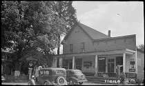
Store and post office in Rhea
Springs, photographed in 1940
205:
140:
Heart of the Valley: A History of
Knoxville, Tennessee
142:(East Tennessee Historical Society, 1976), p. 582.
225:
114:Tennessee Encyclopedia of History and Culture
8:
232:
218:
64:Rhea Springs was the home of Congressman
46:flooded the lower Piney Valley in 1942.
98:
30:was a community once located along the
138:Alice Howell, Lucile Deaderick (ed.),
104:
102:
266:Submerged places in the United States
7:
256:Former populated places in Tennessee
186:
184:
116:, 2002. Retrieved: 13 January 2009.
251:Geography of Rhea County, Tennessee
204:. You can help Knowledge (XXG) by
14:
188:
200:geography–related article is a
276:East Tennessee geography stubs
1:
125:Tennessee Valley Authority,
292:
261:Tennessee Valley Authority
183:
44:Tennessee Valley Authority
82:Austins Mill, Tennessee
70:John Randolph Neal, Jr.
198:Rhea County, Tennessee
36:Rhea County, Tennessee
24:
22:
163: /
72:(1876–1959).
87:Loyston, Tennessee
25:
213:
212:
167:35.680°N 84.827°W
283:
234:
227:
220:
192:
185:
178:
177:
175:
174:
173:
168:
164:
161:
160:
159:
156:
143:
136:
130:
123:
117:
108:Bettye Broyles,
106:
291:
290:
286:
285:
284:
282:
281:
280:
241:
240:
239:
238:
181:
172:35.680; -84.827
171:
169:
165:
162:
157:
154:
152:
150:
149:
147:
146:
137:
133:
124:
120:
107:
100:
95:
78:
55:Tennessee River
17:
12:
11:
5:
289:
287:
279:
278:
273:
268:
263:
258:
253:
243:
242:
237:
236:
229:
222:
214:
211:
210:
193:
145:
144:
131:
118:
97:
96:
94:
91:
90:
89:
84:
77:
74:
15:
13:
10:
9:
6:
4:
3:
2:
288:
277:
274:
272:
269:
267:
264:
262:
259:
257:
254:
252:
249:
248:
246:
235:
230:
228:
223:
221:
216:
215:
209:
207:
203:
199:
194:
191:
187:
182:
179:
176:
141:
135:
132:
128:
122:
119:
115:
111:
105:
103:
99:
92:
88:
85:
83:
80:
79:
75:
73:
71:
67:
62:
60:
56:
52:
47:
45:
41:
40:Watts Bar Dam
37:
33:
29:
21:
206:expanding it
195:
180:
148:
139:
134:
126:
121:
113:
66:John R. Neal
63:
48:
28:Rhea Springs
27:
26:
170: /
110:Rhea County
59:Chattanooga
32:Piney River
245:Categories
158:84°49′37″W
155:35°40′48″N
93:References
76:See also
42:by the
51:spring
196:This
202:stub
112:.
34:in
247::
101:^
61:.
233:e
226:t
219:v
208:.
Text is available under the Creative Commons Attribution-ShareAlike License. Additional terms may apply.