29:
154:
The summit is the highest point of a short, difficult to access secondary ridge that branches off north of the Rilets ridge, one of the two main ridges of
Central Rila. Rilets is a bare, rocky peak resembling a huge granite pyramid. A large part of the summit, as well as the crest of the secondary
180:. At its southwestern foot are the Devil's Lakes. The ridge to the north of the summit bisects and on a terrace enclosed by the two secondary ridges is located the Black Lake. In the north, the slopes of the Rilets reach the valley of the Rilska River.
155:
ridge, is covered with huge and unstable boulders. The area around the summit is difficult to navigate, with extensive sections of rock debris alternating with belts of impenetrable dwarf mountain pine (
322:
264:Мичев (Michev), Николай (Nikolay); Михайлов (Mihaylov), Цветко (Tsvetko); Вапцаров (Vaptsarov), Иван (Ivan); Кираджиев (Kiradzhiev), Светлин (Svetlin) (1980).
353:
375:
380:
58:
293:
51:
346:
Rila
Monastery Nature Park. Management Plan 2004–2013 (Природен парк "Рилски манастир". План за управление 2004–2013)
370:
148:
187:
section of
Northwestern Rila. The nearest mountain refuge is Ribni Ezera at altitude of 2,230 m.
144:
344:
316:
124:
289:
288:] (in Bulgarian). София (Sofia): Книгоиздателска къща „Труд“ ("Trud" Press). 2012.
169:
105:
364:
338:] (in Bulgarian). София (Sofia): Медицина и физкултура (Meditsina i fizkultura).
173:
165:
184:
157:
140:
73:
60:
136:
98:
247:
28:
204:
202:
200:
177:
161:). Ascent in winter is difficulty category and requires alpine tools.
41:
139:
reaching height of 2,713 m. It is named after the 19th-century
273:
208:
132:
112:
168:
and Iliyna. In a cirque on its eastern slope is situated
164:
Rilets is part of the watershed ridge between the rivers
305:Върховете на Рила. Пътеводител към високата планина
104:
94:
89:
50:
40:
35:
21:
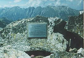
183:From the summit there are impressive views of the
309:The Summits of Rila. Guide to the High Mountain
231:
229:
303:Грънчаров (Grancharov), Румен (Rumen) (2000).
131:) is a summit in the northwestern part of the
8:
330:Радучев (Raduchev), Живко (Zhivko) (1988).
321:: CS1 maint: location missing publisher (
235:
18:
286:Great Encyclopaedia "Bulgaria", Volume 10
196:
343:Yankov (Янков), Petar (Петър) (2004).
314:
282:Голяма енциклопедия „България“. Том 10
220:
209:Geographic Dictionary of Bulgaria 1980
276:): Наука и култура (Nauka i kultura).
7:
311:] (in Bulgarian). София (Sofia).
248:Great Encyclopaedia "Bulgaria" 2012
14:
354:Ministry of Environment and Water
270:Geographic Dictionary of Bulgaria
376:Landforms of Kyustendil Province
151:, where it is the highest peak.
27:
1:
272:] (in Bulgarian). София (
266:Географски речник на България
46:2,713 m (8,901 ft)
381:Two-thousanders of Bulgaria
397:
149:Rila Monastery Nature Park
128:
74:42.1157000°N 23.4617000°E
26:
352:(in Bulgarian). Sofia:
16:Bulgarian mountain peak
79:42.1157000; 23.4617000
176:in Bulgaria and the
147:. It is located in
133:Rila mountain range
70: /
238:, pp. 166–167
36:Highest point
371:Mountains of Rila
332:Рила. Пътеводител
118:
117:
388:
357:
351:
339:
326:
320:
312:
299:
277:
251:
245:
239:
233:
224:
218:
212:
206:
178:Balkan Peninsula
135:in southwestern
130:
108:
85:
84:
82:
81:
80:
75:
71:
68:
67:
66:
63:
31:
19:
396:
395:
391:
390:
389:
387:
386:
385:
361:
360:
349:
342:
329:
313:
302:
296:
280:
263:
260:
255:
254:
246:
242:
236:Grancharov 2000
234:
227:
219:
215:
207:
198:
193:
106:
78:
76:
72:
69:
64:
61:
59:
57:
56:
17:
12:
11:
5:
394:
392:
384:
383:
378:
373:
363:
362:
359:
358:
340:
327:
300:
294:
278:
259:
256:
253:
252:
250:, p. 3730
240:
225:
213:
195:
194:
192:
189:
172:, the largest
170:Smradlivo Lake
116:
115:
113:Rila Mountains
110:
102:
101:
96:
92:
91:
87:
86:
54:
48:
47:
44:
38:
37:
33:
32:
24:
23:
22:Rilets (Рилец)
15:
13:
10:
9:
6:
4:
3:
2:
393:
382:
379:
377:
374:
372:
369:
368:
366:
355:
348:
347:
341:
337:
333:
328:
324:
318:
310:
306:
301:
297:
295:9789548104326
291:
287:
283:
279:
275:
271:
267:
262:
261:
257:
249:
244:
241:
237:
232:
230:
226:
222:
217:
214:
211:, p. 410
210:
205:
203:
201:
197:
190:
188:
186:
181:
179:
175:
171:
167:
162:
160:
159:
152:
150:
146:
145:Aleksi Rilets
142:
138:
134:
126:
122:
114:
111:
109:
103:
100:
97:
93:
88:
83:
65:23°27′42.12″E
55:
53:
49:
45:
43:
39:
34:
30:
25:
20:
345:
335:
331:
308:
304:
285:
281:
269:
265:
243:
223:, p. 28
216:
182:
174:glacial lake
163:
156:
153:
120:
119:
107:Parent range
62:42°6′56.52″N
336:Rila. Guide
221:Yankov 2004
77: /
52:Coordinates
365:Categories
258:References
185:Malyovitsa
158:Pinus mugo
143:architect
317:cite book
191:Citations
141:Bulgarian
125:Bulgarian
90:Geography
42:Elevation
137:Bulgaria
99:Bulgaria
95:Location
292:
166:Rilska
121:Rilets
350:(PDF)
334:[
307:[
284:[
274:Sofia
268:[
129:Рилец
323:link
290:ISBN
367::
319:}}
315:{{
228:^
199:^
127::
356:.
325:)
298:.
123:(
Text is available under the Creative Commons Attribution-ShareAlike License. Additional terms may apply.