325:
that the capacity should be raised to 50 cumecs. The higher discharge rates are mainly due to climate change and land use changes which result in water reaching the river more quickly due to there being a greater area of impermeable surfaces in the Foss catchment to allow for infiltration to occur. This causes rivers to fill up more quickly than in the past. A higher pumping capacity has been achieved by installing eight new 500 kW pumps of the same size into the existing holes of the old pumps. Using pumps of a different size would have caused significant delays to the project. Modern technology allowed the same number and size of pumps to be used whilst still increasing the maximum pumping capacity by more than 65%. Each pump weighs 6.5 tonnes and has variable speeds to give operators more control over water levels on the Foss. In comparison, the old pumps could only be switched on or off and had no variable speeds. Work began in
September 2016 to replace the pumps with each pump taking a week to install. The barrier was operational with maximum pumping capacity by the winter of 2017
136:
raising water levels and flooding properties along the River Foss. The pumps next to the flood gate move water around the barrier via a side culvert so that it can continue to drain into the Ouse. This prevents water levels on the Foss rising when the barrier is closed. The Ouse’s normal water level at York is approximately 5 metres AOD (Above
Ordnance Datum). When the river level reaches 7.5 metres AOD, the barrier is lowered into the Foss, shutting it off from the Ouse. The electrically driven barrier takes less than five minutes to lower into position. The barrier operates as a ‘turn and lift’ gate (see below) so it opens and closes in a similar way to a garage door. The pump-house attached to the barrier maintain the water level in the Foss at around 6.5 metres AOD. When the flood subsides and the level of the Ouse drops back to 6.5 metres, the levels in both rivers are equalised so the barrier opens, and the pumps shut down.
333:
frame was used to house this extra storey. This made the structure lighter so that the existing foundations didn’t need fortifying, as this would have delayed the project significantly. Two new independently sourced high voltage power supplies have been connected to the site, in case one is compromised during a flood event. In the event that both power supplies fail, there are four backup diesel generators capable of running the pumps at full capacity. These generators are situated on the newly built platform so they are above the height of the floodwaters. A large fuel tank can supply the generators running at full capacity for 48 hours. If an event lasts longer than this there is a pipe that runs from the tank to Tower Street so it can be refilled during an event. A fifth separate, smaller generator can run the rest of the building’s electrics.
251:
198:
240:
227:
27:
216:
342:
measures in place upstream of York to reduce river levels, such as natural flood management. These will ‘slow the flow’ and manage river levels throughout the Swale, Ure, Nidd and Ouse catchments. On the River Foss, the
Environment Agency has started work to build a flood storage area north-east of Strensall. This will reduce the risk of flooding to almost 500 properties downstream.
124:
328:
The Foss
Barrier gate also needed replacing so that it meets standards set by other improved flood defences in York. In 2021 a new gate that is 40 cm taller and weighing 18 tonnes was installed. This is the largest size the gate could be and still fit into the existing rotate and lift mechanism.
312:
Before construction, an analysis was carried out to determine the realistic maximum flow rates of the River Foss during an event. This indicated that a flow of 30 ms (metres cubed/tonnes of water per second/ cumecs) was very unlikely to be exceeded. As a result the pumping station capacity was set to
332:
Another upgrade was to increase the resilience of the station to withstand flooding. This was achieved by building an extra storey onto the original building to raise the electrics above flood level making the operation of the barrier and pumping station flood proof. Instead of using bricks, a steel
324:
Following the 2015 Boxing Day event £38 million was allocated to upgrade the barrier and the surrounding infrastructure. The improvement with the highest priority was to increase pumping capacity at the barrier. A similar study to the one conducted for the original barrier was carried out and found
135:
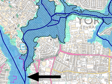
consists of a retractable floodgate and pumping station owned and managed by the
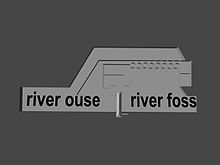
Environment Agency. It straddles the River Foss in York, just above the confluence (where two rivers join) with the River Ouse. The barrier’s purpose is to prevent water from the Ouse flowing upstream into the Foss,
341:
The York Flood
Alleviation Scheme project team designed this defence so that it can protect York from extreme flood events up until 2039. This includes future rises in river levels due to climate change and changes in land use. After this point, the Environment Agency plans to have additional
267:
292:
308:
After many years when the River Foss breached its banks and flooded surrounding properties, the York Water
Authority began working on the Foss Barrier after floods in 1982. It was first put into operation and tested in 1987.
377:
345:
The Foss
Barrier is part of a wider scheme that includes weirs, dams, temporary storage schemes, floodwalls and barriers that all contribute to reducing flood risk in the event of an extraordinary weather event.
270:
274:
273:
269:
268:
275:
295:
299:
298:
294:
293:
300:
272:
297:
415:
464:
454:
271:
296:
44:
110:
91:
63:
469:
48:
70:
250:
77:
197:
37:
59:
239:
459:
226:
397:
84:
407:
448:
363:"GaugeMap – Latest River, Flow and Groundwater Levels Map for Britain & Ireland"
362:
402:
26:
215:
430:
417:
123:
196:
408:
Are you at risk of flooding? Enter your post code here to find out
290:
265:
249:
238:
225:
214:
20:
398:
Live flood warnings for the River Ouse at the Foss
Barrier
172:
5.05 metres (16.6 ft) to 7.9 metres (26 ft)
287:
History of the
Barrier and the 2015 Boxing Day Flood
51:. Unsourced material may be challenged and removed.
337:Looking Forwards and Other Flood defence scheme
8:
178:10.2 metres (33 ft) on 4 November 2000
207:
143:
111:Learn how and when to remove this message
261:
122:
354:
254:Foss River Barrier in closed position
195:Possible flooding around the barrier
7:
49:adding citations to reliable sources
465:Flood control in the United Kingdom
243:Foss River barrier in open position
14:
455:Buildings and structures in York
219:side view without retaining wall
25:
403:Sign up for flood warnings here
36:needs additional citations for
382:maps.environment-agency.gov.uk
230:Top view of Foss river barrier
1:
191:links to Shoothill GaugeMap
486:
378:"What's in your backyard?"
16:Floodgate in York, England
189:Link to current levels:
176:Highest level on record:
431:53.952333°N 1.078417°W
305:
279:
255:
244:
231:
220:
201:
128:
470:River Ouse, Yorkshire
376:Agency, Environment.
303:
278:
253:
242:
229:
218:
200:
126:
436:53.952333; -1.078417
60:"River Foss Barrier"
45:improve this article
427: /
209:
145:
306:
280:
256:
245:
232:
221:
208:
202:
144:
129:
301:
284:
283:
276:
260:
259:
248:With barrier down
206:
205:
121:
120:
113:
95:
477:
442:
441:
439:
438:
437:
432:
428:
425:
424:
423:
420:
386:
385:
373:
367:
366:
359:
302:
277:
262:
210:
146:
140:Site information
116:
109:
105:
102:
96:
94:
53:
29:
21:
485:
484:
480:
479:
478:
476:
475:
474:
445:
444:
435:
433:
429:
426:
421:
418:
416:
414:
413:
394:
389:
375:
374:
370:
361:
360:
356:
352:
339:
322:
316:
291:
289:
266:
237:With barrier up
142:
117:
106:
100:
97:
54:
52:
42:
30:
17:
12:
11:
5:
483:
481:
473:
472:
467:
462:
460:Flood barriers
457:
447:
446:
411:
410:
405:
400:
393:
392:External links
390:
388:
387:
368:
353:
351:
348:
338:
335:
321:
318:
288:
285:
282:
281:
258:
257:
246:
234:
233:
222:
204:
203:
193:
187:
186:
185:
179:
173:
170:Typical range:
167:
161:
155:
141:
138:
127:Map of Barrier
119:
118:
101:September 2023
33:
31:
24:
15:
13:
10:
9:
6:
4:
3:
2:
482:
471:
468:
466:
463:
461:
458:
456:
453:
452:
450:
443:
440:
409:
406:
404:
401:
399:
396:
395:
391:
383:
379:
372:
369:
364:
358:
355:
349:
347:
343:
336:
334:
330:
326:
319:
317:
314:
310:
286:
264:
263:
252:
247:
241:
236:
235:
228:
223:
217:
212:
211:
199:
194:
192:
188:
183:
180:
177:
174:
171:
168:
165:
162:
159:
156:
153:
152:Station name:
150:
149:
148:
147:
139:
137:
134:
125:
115:
112:
104:
93:
90:
86:
83:
79:
76:
72:
69:
65:
62: –
61:
57:
56:Find sources:
50:
46:
40:
39:
34:This article
32:
28:
23:
22:
19:
419:53°57′08.4″N
412:
381:
371:
357:
344:
340:
331:
327:
323:
320:Improvements
315:
311:
307:
304:Barrier fail
190:
181:
175:
169:
163:
157:
154:Foss Barrier
151:
133:Foss Barrier
132:
130:
107:
98:
88:
81:
74:
67:
55:
43:Please help
38:verification
35:
18:
434: /
422:1°04′42.3″W
313:30 cumecs.
182:Site datum:
164:River name:
158:Station ID:
449:Categories
350:References
213:Side view
166:River Ouse
71:newspapers
224:Top view
184:0.00mAOD
85:scholar
87:
80:
73:
66:
58:
92:JSTOR
78:books
160:8081
131:The
64:news
47:by
451::
380:.
384:.
365:.
114:)
108:(
103:)
99:(
89:·
82:·
75:·
68:·
41:.
Text is available under the Creative Commons Attribution-ShareAlike License. Additional terms may apply.