830:
811:
177:
233:
148:
205:
160:
36:
240:
212:
184:
819:
922:
There have been very few raft expeditions on the Lohit River. It is a medium volume continuous Class 4+/5 river in its upper alpine reaches and becomes pool drop towards the latter end of the trip. Rafting was first started in
February 1994 by the Indian Army and the first successful kayak descent
829:
914:, also referred to as the Bhupen Hazarika Setu, is a beam bridge and longest in India, connecting the northeast states of Assam and Arunachal Pradesh. The bridge spans the Lohit River, from the village of Dhola in the south to Sadiya to the north.
841:
bloom in many hues in the upper reaches, orchids reveal themselves in the lower groves. This is indeed a treasure house of medicinal plant and herbs, and the home of Mishmi
1162:
837:
Thickly forested for the most part, alpine vegetation gives way to subtropical forests, and then to some of the densest tropical jungles in all of India.
481:
1110:
1137:
1157:
176:
119:
1084:
232:
57:
786:
where it is known as the Lohit River. Tempestuous and turbulent, and known as the river of blood partly attributable to the
757:
100:
810:
204:
72:
53:
79:
327:
46:
993:
414:
899:
The Lohit river comes into India from China and flows near India's easternmost inhabited tip, at a place called
1172:
1167:
952:
911:
974:
86:
745:
392:
305:
68:
1142:
1066:
1028:
1009:"The Lohit-Brahmaputra between Assam and South-Eastern Tibet, November, 1907, to January, 1908"
795:
779:
733:
705:
661:
604:
557:
1058:
1020:
842:
147:
934:
929:, a Hindu pilgrimage is situated on the lower reaches of Lohit. Over 70,000 devotees and
93:
946:
926:
889:
861:
823:
787:
741:
713:
655:
1049:
Kingdon Ward, F.; Smith, Malcolm (November 1934), "The
Himalaya East of the Tsangpo",
603:
Demwe Lower hydroelectric plant (basin size: 20,174 km (7,789 sq mi)),
1151:
853:
721:
884:
temples. This region experiences a mix of many cultures near the tripoint between
838:
791:
753:
692:
380:
293:
778:. The combined river descends through this mountainous region and surges through
904:
799:
775:
455:
450:
396:
309:
159:
35:
893:
774:), which originates to its northeast. The two rivers merge below the town of
496:
483:
429:
416:
342:
329:
17:
877:
782:
in India for 200 kilometres (120 mi) before entering the plains of
1070:
1032:
900:
857:
865:
846:
765:
1062:
1024:
1008:
876:
theology gives way to animist belief, in turn replaced by
Theravada
818:
752:(also called Rongto Chu and Zayul Ngu Chu), which originates in the
930:
885:
881:
873:
869:
828:
817:
809:
783:
737:
729:
725:
620:(Period: 1984/85-2003/04)1,234 m/s (43,600 cu ft/s)
608:
565:
561:
467:
400:
313:
1111:"Arunachal Pradesh planning to promote tourism at Parsuram Kund"
833:
Lohit river at the Dhola–Sadiya Bridge in the
Brahmaputra Valley
29:
1037:
Tibetans call it the Zayul Chu, and the Mishmi name is Tellu
849:
plant, prized the world over for its medicinal properties.
814:
Lohit river at Kahoo, soon after entering
Arunachal Pradesh
822:
The Lohit River entering the
Brahmaputra Valley plains at
988:
986:
984:
907:
uses this river for various expeditions and training.
933:
take holy dip its water each year on the occasion of
969:
967:
685:
675:
667:
653:
648:
634:
624:
614:
597:
589:
571:
550:
542:
530:
522:
512:
473:
461:
449:
406:
386:
376:
358:
319:
299:
289:
280:
272:
264:
259:
136:
60:. Unsourced material may be challenged and removed.
1085:"70,000 devotees take holy dip in Parshuram Kund"
864:, fervent Buddhists and migrants from across the
856:hold sway in the hills. In the plains are the
8:
708:word Lohit meaning blood, also known as the
577:3,437.9 m/s (121,410 cu ft/s)
640:4,273 m/s (150,900 cu ft/s)
158:
802:) at the head of the Brahmaputra valley.
120:Learn how and when to remove this message
1138:Report Assam Floods 16 Jun 2006 - Lohit
963:
534:41,499 km (16,023 sq mi)
748:, through a merger of two rivers: the
630:263 m/s (9,300 cu ft/s)
133:
7:
1163:Tributaries of the Brahmaputra River
58:adding citations to reliable sources
1143:Lohit River marked on OpenStreetMap
239:
211:
183:
27:River in Arunachal Pradesh in India
25:
872:. As the Lohit journeys through,
238:
231:
210:
203:
182:
175:
152:Lohit River in Arunachal Pradesh
146:
34:
923:of the river in December 2003.
276:Tibet, Arunachal Pradesh, Assam
45:needs additional citations for
770:
761:
681:Zuao, Gholum, Lati, Noa Dihang
475: • coordinates
408: • coordinates
321: • coordinates
1:
364:5,200 m (17,100 ft)
281:Physical characteristics
194:Show map of Arunachal Pradesh
514: • elevation
360: • elevation
1158:Rivers of Arunachal Pradesh
937:, in the month of January.
704:, which name came from the
599: • location
552: • location
463: • location
388: • location
301: • location
1189:
636: • maximum
626: • minimum
616: • average
573: • average
1115:Daily News & Analysis
1007:Williamson, Noël (1909).
994:"Lohit River Basin Study"
644:
585:
581:
538:
526:560 km (350 mi)
445:
372:
368:
285:
169:
157:
145:
1109:PTI (19 December 2012).
1051:The Geographical Journal
1013:The Geographical Journal
687: • right
518:108 m (354 ft)
1083:PTI (18 January 2013).
790:, it flows through the
746:Tibet Autonomous Region
740:. It is formed in the
677: • left
834:
826:
815:
756:range, and Zayul Chu (
832:
821:
813:
691:Dav, Delai, Tiding,
191:Mouth of Lohit River
54:improve this article
975:"Upper Brahmaputra"
953:Dhola–Sadiya Bridge
912:Dhola–Sadiya Bridge
649:Basin features
493: /
456:Siang (Brahmaputra)
426: /
343:29.1629°N 97.0837°E
339: /
219:Lohit River (India)
1089:The Indian Express
835:
827:
816:
732:, which joins the
430:29.463°N 97.1366°E
247:Lohit River (Asia)
780:Arunachal Pradesh
734:Brahmaputra River
698:
697:
662:Brahmaputra River
605:Arunachal Pradesh
558:Brahmaputra River
497:27.800°N 95.467°E
222:Show map of India
164:Lohit River basin
130:
129:
122:
104:
16:(Redirected from
1180:
1126:
1125:
1123:
1121:
1106:
1100:
1099:
1097:
1095:
1080:
1074:
1073:
1046:
1040:
1039:
1004:
998:
997:
990:
979:
978:
971:
772:
763:
750:Kangri Karpo Chu
736:in the state of
724:, is a river in
688:
678:
658:
637:
627:
617:
600:
574:
553:
508:
507:
505:
504:
503:
498:
494:
491:
490:
489:
486:
441:
440:
438:
437:
436:
431:
427:
424:
423:
422:
419:
409:
389:
361:
354:
353:
351:
350:
349:
348:29.1629; 97.0837
344:
340:
337:
336:
335:
332:
322:
302:
251:
250:Show map of Asia
242:
241:
235:
223:
214:
213:
207:
195:
186:
185:
179:
162:
150:
134:
125:
118:
114:
111:
105:
103:
62:
38:
30:
21:
1188:
1187:
1183:
1182:
1181:
1179:
1178:
1177:
1173:Rivers of Assam
1168:Rivers of Tibet
1148:
1147:
1134:
1129:
1119:
1117:
1108:
1107:
1103:
1093:
1091:
1082:
1081:
1077:
1063:10.2307/1786924
1048:
1047:
1043:
1025:10.2307/1777190
1006:
1005:
1001:
992:
991:
982:
973:
972:
965:
961:
943:
935:Makar Sankranti
920:
808:
686:
676:
654:
635:
625:
615:
598:
572:
551:
515:
501:
499:
495:
492:
487:
484:
482:
480:
479:
476:
464:
435:29.463; 97.1366
434:
432:
428:
425:
420:
417:
415:
413:
412:
407:
387:
359:
347:
345:
341:
338:
333:
330:
328:
326:
325:
320:
300:
255:
254:
253:
252:
249:
248:
245:
244:
243:
226:
225:
224:
221:
220:
217:
216:
215:
198:
197:
196:
193:
192:
189:
188:
187:
165:
153:
141:
138:
126:
115:
109:
106:
63:
61:
51:
39:
28:
23:
22:
15:
12:
11:
5:
1186:
1184:
1176:
1175:
1170:
1165:
1160:
1150:
1149:
1146:
1145:
1140:
1133:
1132:External links
1130:
1128:
1127:
1101:
1075:
1057:(5): 369–394,
1041:
999:
980:
962:
960:
957:
956:
955:
950:
942:
939:
927:Parshuram Kund
919:
916:
890:Southeast Asia
824:Parshuram Kund
807:
804:
794:, to meet the
788:lateritic soil
696:
695:
689:
683:
682:
679:
673:
672:
669:
665:
664:
659:
651:
650:
646:
645:
642:
641:
638:
632:
631:
628:
622:
621:
618:
612:
611:
601:
595:
594:
591:
587:
586:
583:
582:
579:
578:
575:
569:
568:
556:Confluence of
554:
548:
547:
544:
540:
539:
536:
535:
532:
528:
527:
524:
520:
519:
516:
513:
510:
509:
502:27.800; 95.467
477:
474:
471:
470:
465:
462:
459:
458:
453:
447:
446:
443:
442:
410:
404:
403:
390:
384:
383:
378:
374:
373:
370:
369:
366:
365:
362:
356:
355:
323:
317:
316:
303:
297:
296:
291:
287:
286:
283:
282:
278:
277:
274:
270:
269:
266:
262:
261:
257:
256:
246:
237:
236:
230:
229:
228:
227:
218:
209:
208:
202:
201:
200:
199:
190:
181:
180:
174:
173:
172:
171:
170:
167:
166:
163:
155:
154:
151:
143:
142:
139:
128:
127:
42:
40:
33:
26:
24:
14:
13:
10:
9:
6:
4:
3:
2:
1185:
1174:
1171:
1169:
1166:
1164:
1161:
1159:
1156:
1155:
1153:
1144:
1141:
1139:
1136:
1135:
1131:
1116:
1112:
1105:
1102:
1090:
1086:
1079:
1076:
1072:
1068:
1064:
1060:
1056:
1052:
1045:
1042:
1038:
1034:
1030:
1026:
1022:
1018:
1014:
1010:
1003:
1000:
995:
989:
987:
985:
981:
976:
970:
968:
964:
958:
954:
951:
948:
945:
944:
940:
938:
936:
932:
928:
924:
918:River rafting
917:
915:
913:
908:
906:
902:
897:
895:
891:
887:
883:
879:
875:
871:
867:
863:
859:
855:
850:
848:
844:
840:
839:Rhododendrons
831:
825:
820:
812:
805:
803:
801:
797:
793:
789:
785:
781:
777:
773:
767:
759:
755:
751:
747:
743:
739:
735:
731:
727:
723:
719:
715:
711:
707:
703:
694:
690:
684:
680:
674:
670:
666:
663:
660:
657:
652:
647:
643:
639:
633:
629:
623:
619:
613:
610:
606:
602:
596:
592:
588:
584:
580:
576:
570:
567:
563:
559:
555:
549:
545:
541:
537:
533:
529:
525:
521:
517:
511:
506:
478:
472:
469:
466:
460:
457:
454:
452:
448:
444:
439:
411:
405:
402:
398:
394:
391:
385:
382:
379:
375:
371:
367:
363:
357:
352:
324:
318:
315:
311:
307:
304:
298:
295:
292:
288:
284:
279:
275:
271:
267:
263:
258:
234:
206:
178:
168:
161:
156:
149:
144:
135:
132:
124:
121:
113:
102:
99:
95:
92:
88:
85:
81:
78:
74:
71: –
70:
69:"Lohit River"
66:
65:Find sources:
59:
55:
49:
48:
43:This article
41:
37:
32:
31:
19:
1118:. Retrieved
1114:
1104:
1092:. Retrieved
1088:
1078:
1054:
1050:
1044:
1036:
1016:
1012:
1002:
925:
921:
909:
898:
880:and then by
851:
836:
792:Mishmi Hills
769:
754:Kangri Karpo
749:
742:Zayul County
717:
709:
701:
699:
656:River system
381:Kangri Karpo
294:Kangri Karpo
268:China, India
131:
116:
107:
97:
90:
83:
76:
64:
52:Please help
47:verification
44:
1019:: 363–383.
947:Zayü County
905:Indian Army
868:hills from
800:Brahmaputra
702:Lohit River
668:Tributaries
500: /
433: /
397:Zayu County
346: /
310:Zayu County
137:Lohit River
18:River Lohit
1152:Categories
1120:13 January
1094:13 January
959:References
949:(in Tibet)
894:South Asia
531:Basin size
421:97°08′12″E
418:29°27′47″N
377:2nd source
334:97°05′01″E
331:29°09′46″N
140:Zayü River
80:newspapers
710:Zayul Chu
590:Discharge
543:Discharge
110:July 2011
941:See also
878:Buddhism
862:Singphos
860:and the
858:Khamptis
771:Cháyú Hé
714:Tibetans
706:Assamese
273:Province
260:Location
1071:1786924
1033:1777190
996:. 2009.
901:Kibithu
874:Tibetan
854:Mishmis
758:Chinese
744:of the
722:Mishmis
720:by the
712:by the
488:95°28′E
485:27°48′N
265:Country
94:scholar
1069:
1031:
931:sadhus
903:. The
892:, and
866:Patkai
847:coptis
845:, the
806:Course
768::
766:pinyin
760::
693:Dibang
671:
593:
546:
523:Length
290:Source
96:
89:
82:
75:
67:
1067:JSTOR
1029:JSTOR
886:Tibet
882:Hindu
870:Burma
843:teeta
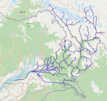
796:Siang
784:Assam
738:Assam
730:India
726:China
718:Tellu
609:India
566:India
562:Assam
468:Assam
451:Mouth
401:China
393:Tibet
314:China
306:Tibet
101:JSTOR
87:books
1122:2019
1096:2019
910:The
852:The
776:Rima
728:and
716:and
700:The
73:news
1059:doi
1021:doi
762:察隅河
56:by
1154::
1113:.
1087:.
1065:,
1055:84
1053:,
1035:.
1027:.
1017:34
1015:.
1011:.
983:^
966:^
896:.
888:,
764:;
607:,
564:,
560:,
399:,
395:,
312:,
308:,
1124:.
1098:.
1061::
1023::
977:.
798:(
123:)
117:(
112:)
108:(
98:·
91:·
84:·
77:·
50:.
20:)
Text is available under the Creative Commons Attribution-ShareAlike License. Additional terms may apply.