905:. This was designed by F. A. Sims, who was the senior designer and resident engineer for the bridges department of the West Riding County Council, and it was opened in 1961. It consists of a continuous beam, supported at its ends and by two sloping legs, which are hinged at both ends. The side spans are 140 feet (43 m) long, while the centre span is 190 feet (58 m) long. It was probably the first bridge in England to use prestressing cables which did not pass through the concrete sections, and one of the first to use precast concrete hinges. When it was built, it was the largest bridge of this kind in Europe, and in 1964 the
31:
643:
623:
473:
440:
359:
312:
265:
596:
556:
533:
513:
493:
386:
332:
285:
238:
753:
690:
198:
927:, it passes the site of Norton mill and Norton Priory before passing under Tanpit bridge, a single arched bridge constructed of dressed stone with brick lined soffits in the early nineteenth century. By the time it reaches another railway line, it is only 16 feet (4.9 m) above sea level, and the channel is embanked on both sides to prevent flooding of the surrounding low-lying land.
760:
746:
670:
650:
616:
576:
466:
447:
420:
413:
352:
305:
258:
218:
717:
379:
724:
710:
406:
2086:
843:, just to the west of Featherstone, and close to the 160-foot (49 m) contour. It is called Went Beck at this point, and flows generally eastwards, to the south of Featherstone. Just before it is crossed by the B6428 at Little Went bridge, it is joined by Hardwick Beck, flowing north-eastwards from the lakes of Nostell Park, once the site of
934:
crosses, the river used to take a winding route round the southern edge of Stubbs Common, but a new straight channel has been made, which has counter drains on either side, to collect seepage through the banks. Lake Drain joins the river at Lake Mouth, just beyond the point at which the old course of
971:
During the late 1800s and early 1900s, the river was seriously polluted as a result of coal mining and the growth of population to support the mining operations. In many cases, villages developed around the mines and had inadequate or no sewage treatment plants, while the mines discharged mine water
975:
The state of the Don was similarly lifeless, but by the 1970s, water quality in the lower Went was slightly improved, as a result of natural purification of the effluents being added to the river, and a small population of fish re-established itself. Most are thought to have been swept down the Don
1126:
Reasons for the ecological quality being less than good include runoff from agricultural land, discharge from sewage treatment works, and physical modification of the channel, to provide flood production structures which impede the movement of fish along the river. Like most rivers in the UK, the
1028:
The
Environment Agency assesses the water quality within the river systems in England. Each is given an overall ecological status, which may be one of five levels: high, good, moderate, poor and bad. There are several components that are used to determine this, including biological status, which
1024:
bridge. The operation was a success, as the fish colonised the river upstream and downstream from the release point, and soon became self-sustaining. As a consequence, the Went is now an excellent coarse fishery. There are also populations of chub and dace in the Don near
Doncaster, which are
976:
from still waters much higher up than the mouth of the Went, but they survived the transit downstream to take refuge in the Went. As water quality continued to improve, the fish became self-sustaining by the 1980s, and populations of
1127:
chemical status changed from good to fail in 2019, due to the presence of polybrominated diphenyl ethers (PBDE), perfluorooctane sulphonate (PFOS) and mercury compounds, none of which had previously been included in the assessment.
972:
containing ochre, and large quantities of solids, which were deposited on the bed and choked vegetation. As a result, the fish population was almost entirely destroyed, and the river remained without fish until the 1970s.
992:
began to spread upstream. While these species were suited to the ponded nature of the river below
Sykehouse, the river above there is faster flowing, and more suitable for riverine species of fish such as
855:
1258:
935:
the river rejoins the new. The
Doncaster to Selby railway line crosses next, after which an early nineteenth century red-brick bridge carries a lane over its course at
1362:
1466:
2117:
1414:
2025:
1996:
1310:
1008:
Authority
Fisheries department searched for a source of chub and dace which could be re-introduced. An isolated population was eventually found on the
1206:
161:
2068:
2049:
1652:
1037:
and fish. Chemical status, which compares the concentrations of various chemicals against known safe concentrations, is rated good or fail.
1825:
1794:
1763:
1732:
1687:
2110:
1820:
1789:
1758:
1727:
1682:
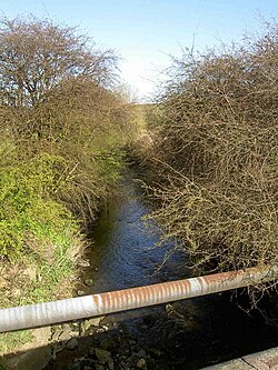
877:, which follows the course of a Roman road at this point. The bridge is called Standing Flat bridge, and is just to the north of
2666:
1191:
2727:
2722:
2469:
2414:
2253:
2103:
154:
2424:
2409:
2203:
2158:
2148:
2213:
2016:
1001:. There was no chance of natural redevelopment of these species, as they had all been eliminated by the pollution.
948:
817:
30:
2168:
179:
1992:
2530:
2188:
1582:
1966:
1940:
1914:
1140:
936:
898:
147:
2090:
2686:
2570:
2308:
2273:
1567:
1184:
1009:
920:
912:
declared it to be a structure of significance in twentieth century engineering. It is grade II listed.
821:
2621:
2616:
2303:
952:
909:
768:
114:
956:
1888:
1656:
2223:
1167:
944:
902:
732:
542:
1016:. They were netted, and in 1981, over 2,000 young chub and dace were released into the river at
1162:
2064:
2061:
A Biographical
Dictionary of Civil Engineers in Great Britain and Ireland: Vol 1: 1500 to 1830
2045:
1572:
1538:
924:
923:, on its northern bank, near which a railway used to cross, which has now been dismantled. At
863:
828:
2636:
2037:
1816:
1785:
1754:
1723:
1678:
1634:
915:
Soon the river is passing through
Brockadale, a steep-sided, wooded valley, before reaching
1157:
2601:
2585:
2565:
1005:
890:
886:
2606:
2540:
2535:
2454:
2368:
2338:
2278:
2233:
1638:
1601:
848:
844:
2716:
2661:
2651:
2459:
2404:
2373:
2298:
2283:
1577:
1548:
1533:
1528:
906:
878:
859:
2701:
2691:
2656:
2641:
2611:
2489:
2484:
2474:
2439:
2429:
2378:
2333:
2293:
2288:
2243:
2183:
1889:"Glossary (see Biological quality element; Chemical status; and Ecological status)"
1562:
1543:
1030:
981:
977:
916:
867:
813:
2681:
2676:
2671:
2646:
2575:
2550:
2545:
2494:
2464:
2444:
2434:
2383:
2358:
2343:
2328:
2323:
2318:
2258:
2228:
2178:
2153:
998:
840:
99:
78:
2631:
2555:
2525:
2520:
2479:
2449:
2399:
2353:
2348:
2313:
2263:
2248:
2238:
2218:
2208:
2193:
2173:
2143:
2138:
1557:
1034:
882:
1482:
1468:
1430:
1416:
1378:
1364:
1326:
1312:
1274:
1260:
1222:
1208:
2580:
2515:
2499:
2419:
2363:
2198:
2163:
1596:
940:
894:
874:
851:
805:
2085:
1152:
140:
2268:
2018:
Domesday to the dawn of the New
Millennium – 900 years of the Don fishery
1021:
994:
931:
2626:
809:
49:
2095:
2560:
1017:
1013:
1591:
985:
960:
901:
bypasses
Wentbridge to the east, and is carried over the river by
831:
is believed to be located somewhere along the valley of the Went.
801:
955:, which was diverted northwards in 1628 by the drainage engineer
2099:
989:
897:
ashlar blocks, and is probably early nineteenth century. The
1519:
2042:
Nicholson Guide Vol 6: Nottingham, York and the North East
1629:
De Rance, Charles E. (January 2011). "The Humber Basin".
1871:
1869:
1867:
1653:"Anglo-Saxon West Yorkshire:The historical background"
1040:
The water quality of the Went was as follows in 2019.
947:
over it. At this point it is running parallel to the
2594:
2508:
2392:
2131:
131:
121:
108:
98:
84:
72:
64:
55:
45:
40:
23:
1655:. West Yorkshire Joint Services. Archived from
1941:"Went from Hoyle Mill Stream to Blowell Drain"
943:, where an aqueduct built in 1905 carries the
881:. The next crossing is the B6474 as it enters
2111:
1085:Went from Hoyle Mill Stream to Blowell Drain
155:
8:
1025:believed to have originated from the Went.
873:Continuing eastwards, it is crossed by the
2118:
2104:
2096:
1967:"Went from Blowell Drain to the River Don"
1177:
187:
162:
148:
1846:
1105:Went from Blowell Drain to the River Don
889:bridge has two arches, made of rockfaced
2059:Skempton, Sir Alec; et al. (2002).
1858:
1042:
35:The river seen from Standing Flat bridge
1915:"Went from Source to Hoyle Mill Stream"
1821:"Topham Ferry Bridge, Topham (1316361)"
1709:
1707:
1705:
1621:
1029:looks at the quantity and varieties of
1004:In order to overcome this problem, the
145:
1066:Went from Source to Hoyle Mill Stream
20:
2033:(Page numbers refer to the pdf file).
1875:
1631:The Water Supply of England and Wales
919:, situated on its southern bank, and
7:
1999:from the original on 14 March 2024.
939:. The river passes to the north of
2031:from the original on 17 July 2019.
1826:National Heritage List for England
1795:National Heritage List for England
1764:National Heritage List for England
1733:National Heritage List for England
1728:"Wentbridge, Darrington (1135505)"
1688:National Heritage List for England
1639:10.1680/twsoeawigucsdas.52628.0005
1097:19.59 square miles (50.7 km)
1078:11.92 square miles (30.9 km)
595:
555:
532:
512:
492:
331:
284:
237:
14:
1790:"Tanpit Bridge, Norton (1148366)"
1117:7.22 square miles (18.7 km)
642:
622:
472:
439:
358:
311:
264:
2084:
1459:
1407:
1355:
1303:
1251:
1199:
816:and flows eastward, joining the
758:
752:
751:
744:
722:
715:
708:
689:
688:
668:
648:
641:
621:
614:
594:
574:
554:
531:
511:
491:
471:
464:
445:
438:
418:
411:
404:
385:
384:
377:
357:
350:
330:
310:
303:
283:
263:
256:
236:
216:
197:
196:
29:
759:
745:
669:
649:
615:
575:
465:
446:
419:
412:
351:
304:
257:
217:
1759:"Wentbridge Viaduct (1323681)"
1012:where Bishop Dyke joins it at
959:, and then heads eastwards to
930:Beyond Went bridge, where the
716:
378:
1:
2044:. Harper Collins Publishers.
1713:Ordnance Survey, 1:25,000 map
723:
709:
564:Willow Bridge Little Smeaton
56:Physical characteristics
1995:. Environment Agency. 2023.
1456:Junction with Hardwick Beck
1253:New Junction Canal aqueduct
405:
123: • elevation
86: • elevation
2015:Firth, Christopher (1997).
1286:New Junction Canal aqueduct
1168:GPX (secondary coordinates)
963:by way of the Dutch River.
110: • location
74: • location
16:River in the United Kingdom
2744:
1683:"Nostell Priory (1262071)"
1094:14.3 miles (23.0 km)
949:Aire and Calder Navigation
866:, before being crossed by
501:A639 Standing Flat Bridge
340:A628 Ackworth Carr Bridge
1188:(Links to map resources)
1163:GPX (primary coordinates)
1138:Map all coordinates using
1114:6.3 miles (10.1 km)
1075:9.2 miles (14.8 km)
767:
738:
731:
702:
697:
682:
677:
662:
657:
635:
631:Old course of River Went
630:
608:
603:
588:
583:
568:
563:
548:
540:
525:
520:
505:
500:
485:
480:
458:
454:
432:
427:
398:
393:
371:
366:
344:
339:
324:
319:
297:
293:B6428 Little Went Bridge
292:
277:
272:
250:
245:
230:
225:
210:
205:
190:
94:
60:
28:
2509:East Riding of Yorkshire
1248:Junction with River Don
1146:Download coordinates as:
951:, and soon it joins the
858:. It then flows between
206:Source near Streethouse
1971:Catchment Data Explorer
1945:Catchment Data Explorer
1919:Catchment Data Explorer
1893:Catchment Data Explorer
847:, but now containing a
827:A possible site of the
2024:. Environment Agency.
1357:A1 viaduct Wentbridge
2093:at Wikimedia Commons
1390:A1 viaduct Wentbridge
1158:GPX (all coordinates)
135:16 miles (26 km)
1973:. Environment Agency
1947:. Environment Agency
1921:. Environment Agency
1895:. Environment Agency
1461:Source of Went Beck
1352:also end of new cut
910:Museum of Modern Art
812:. It rises close to
90:160 feet (49 m)
2728:Rivers of Wakefield
2723:Rivers of Doncaster
2126:Rivers of Yorkshire
1494:Source of Went Beck
1478: /
1426: /
1409:Little Went bridge
1374: /
1322: /
1270: /
1218: /
957:Cornelius Vermuyden
891:magnesian limestone
854:house owned by the
839:The river rises at
698:Old railway bridge
2063:. Thomas Telford.
1861:, pp. 740–743
1483:53.6750°N 1.4066°W
1442:Little Went bridge
1431:53.6631°N 1.3560°W
1379:53.6487°N 1.2551°W
1327:53.6438°N 1.1258°W
1275:53.6582°N 1.0182°W
1223:53.6615°N 0.9907°W
1131:Points of interest
945:New Junction Canal
903:Wentbridge Viaduct
733:New Junction Canal
543:Wentbridge Viaduct
521:B6474 Went Bridge
117:, Reedholme Common
2710:
2709:
2089:Media related to
2070:978-0-7277-2939-2
2051:978-0-00-721114-2
1993:"Chemical Status"
1612:
1611:
1539:Ackworth Moor Top
1512:
1511:
1508:near Streethouse
1124:
1123:
1120:heavily modified
1100:heavily modified
1049:Ecological Status
870:railway viaduct.
864:Ackworth Moor Top
829:Battle of Winwaed
794:
793:
790:
789:
139:
138:
127:0 feet (0 m)
2735:
2120:
2113:
2106:
2097:
2088:
2074:
2055:
2032:
2030:
2023:
2001:
2000:
1989:
1983:
1982:
1980:
1978:
1963:
1957:
1956:
1954:
1952:
1937:
1931:
1930:
1928:
1926:
1911:
1905:
1904:
1902:
1900:
1885:
1879:
1873:
1862:
1856:
1850:
1844:
1838:
1837:
1835:
1833:
1817:Historic England
1813:
1807:
1806:
1804:
1802:
1786:Historic England
1782:
1776:
1775:
1773:
1771:
1755:Historic England
1751:
1745:
1744:
1742:
1740:
1724:Historic England
1720:
1714:
1711:
1700:
1699:
1697:
1695:
1679:Historic England
1675:
1669:
1668:
1666:
1664:
1649:
1643:
1642:
1626:
1520:
1502:
1501:
1499:
1498:
1497:
1495:
1490:
1489:
1488:53.6750; -1.4066
1484:
1479:
1476:
1475:
1474:
1471:
1450:
1449:
1447:
1446:
1445:
1443:
1438:
1437:
1436:53.6631; -1.3560
1432:
1427:
1424:
1423:
1422:
1419:
1398:
1397:
1395:
1394:
1393:
1391:
1386:
1385:
1384:53.6487; -1.2551
1380:
1375:
1372:
1371:
1370:
1367:
1346:
1345:
1343:
1342:
1341:
1339:
1334:
1333:
1332:53.6438; -1.1258
1328:
1323:
1320:
1319:
1318:
1315:
1294:
1293:
1291:
1290:
1289:
1287:
1282:
1281:
1280:53.6582; -1.0182
1276:
1271:
1268:
1267:
1266:
1263:
1242:
1241:
1239:
1238:
1237:
1235:
1230:
1229:
1228:53.6615; -0.9907
1224:
1219:
1216:
1215:
1214:
1211:
1178:
1043:
822:Reedholme Common
762:
761:
755:
754:
748:
747:
726:
725:
719:
718:
712:
711:
692:
691:
672:
671:
652:
651:
645:
644:
625:
624:
618:
617:
604:A19 Went Bridge
598:
597:
578:
577:
558:
557:
535:
534:
515:
514:
495:
494:
475:
474:
468:
467:
449:
448:
442:
441:
422:
421:
415:
414:
408:
407:
388:
387:
381:
380:
361:
360:
354:
353:
334:
333:
314:
313:
307:
306:
287:
286:
267:
266:
260:
259:
240:
239:
220:
219:
200:
199:
188:
164:
157:
150:
141:
87:
75:
33:
21:
2743:
2742:
2738:
2737:
2736:
2734:
2733:
2732:
2713:
2712:
2711:
2706:
2602:Blackburn Brook
2595:South Yorkshire
2590:
2586:Winestead Drain
2566:Lambwath Stream
2504:
2388:
2132:North Yorkshire
2127:
2124:
2082:
2077:
2071:
2058:
2052:
2036:
2028:
2021:
2014:
2010:
2005:
2004:
1991:
1990:
1986:
1976:
1974:
1965:
1964:
1960:
1950:
1948:
1939:
1938:
1934:
1924:
1922:
1913:
1912:
1908:
1898:
1896:
1887:
1886:
1882:
1874:
1865:
1857:
1853:
1845:
1841:
1831:
1829:
1815:
1814:
1810:
1800:
1798:
1784:
1783:
1779:
1769:
1767:
1753:
1752:
1748:
1738:
1736:
1722:
1721:
1717:
1712:
1703:
1693:
1691:
1677:
1676:
1672:
1662:
1660:
1659:on 28 July 2011
1651:
1650:
1646:
1628:
1627:
1623:
1618:
1613:
1517:
1493:
1491:
1487:
1485:
1481:
1480:
1477:
1472:
1469:
1467:
1465:
1464:
1441:
1439:
1435:
1433:
1429:
1428:
1425:
1420:
1417:
1415:
1413:
1412:
1389:
1387:
1383:
1381:
1377:
1376:
1373:
1368:
1365:
1363:
1361:
1360:
1337:
1335:
1331:
1329:
1325:
1324:
1321:
1316:
1313:
1311:
1309:
1308:
1285:
1283:
1279:
1277:
1273:
1272:
1269:
1264:
1261:
1259:
1257:
1256:
1233:
1231:
1227:
1225:
1221:
1220:
1217:
1212:
1209:
1207:
1205:
1204:
1187:
1176:
1175:
1174:
1173:
1172:
1133:
1052:Chemical Status
1006:Yorkshire Water
969:
887:grade II listed
837:
763:
756:
749:
727:
720:
713:
693:
678:Railway bridge
673:
653:
646:
626:
619:
599:
584:Railway bridge
579:
559:
536:
516:
496:
476:
469:
450:
443:
428:Railway bridge
423:
416:
409:
394:Tan House Dike
389:
382:
362:
355:
335:
315:
308:
288:
268:
261:
241:
226:Railway bridge
221:
201:
182:
173:
172:
168:
124:
111:
85:
73:
36:
17:
12:
11:
5:
2741:
2739:
2731:
2730:
2725:
2715:
2714:
2708:
2707:
2705:
2704:
2699:
2694:
2689:
2684:
2679:
2674:
2669:
2664:
2659:
2654:
2649:
2644:
2639:
2634:
2629:
2624:
2619:
2614:
2609:
2604:
2598:
2596:
2592:
2591:
2589:
2588:
2583:
2578:
2573:
2568:
2563:
2558:
2553:
2548:
2543:
2538:
2536:Driffield Beck
2533:
2528:
2523:
2518:
2512:
2510:
2506:
2505:
2503:
2502:
2497:
2492:
2487:
2482:
2477:
2472:
2467:
2462:
2457:
2452:
2447:
2442:
2437:
2432:
2427:
2422:
2417:
2412:
2407:
2402:
2396:
2394:
2393:West Yorkshire
2390:
2389:
2387:
2386:
2381:
2376:
2371:
2366:
2361:
2356:
2351:
2346:
2341:
2336:
2331:
2326:
2321:
2316:
2311:
2306:
2301:
2296:
2291:
2286:
2281:
2279:Pickering Beck
2276:
2271:
2266:
2261:
2256:
2251:
2246:
2241:
2236:
2231:
2226:
2221:
2216:
2211:
2206:
2201:
2196:
2191:
2186:
2181:
2176:
2171:
2166:
2161:
2156:
2151:
2146:
2141:
2135:
2133:
2129:
2128:
2125:
2123:
2122:
2115:
2108:
2100:
2081:
2080:External links
2078:
2076:
2075:
2069:
2056:
2050:
2034:
2011:
2009:
2006:
2003:
2002:
1984:
1958:
1932:
1906:
1880:
1863:
1851:
1847:Nicholson 2006
1839:
1808:
1777:
1746:
1715:
1701:
1670:
1644:
1620:
1619:
1617:
1614:
1610:
1609:
1605:
1604:
1602:Pincheon Green
1599:
1594:
1587:
1586:
1585:
1580:
1575:
1570:
1568:Little Smeaton
1565:
1560:
1553:
1552:
1551:
1546:
1541:
1536:
1531:
1526:
1518:
1516:
1513:
1510:
1509:
1506:
1503:
1462:
1458:
1457:
1454:
1451:
1410:
1406:
1405:
1402:
1399:
1358:
1354:
1353:
1350:
1347:
1306:
1302:
1301:
1298:
1295:
1254:
1250:
1249:
1246:
1243:
1202:
1198:
1197:
1194:
1189:
1182:
1171:
1170:
1165:
1160:
1155:
1149:
1143:
1136:
1135:
1134:
1132:
1129:
1122:
1121:
1118:
1115:
1112:
1109:
1106:
1102:
1101:
1098:
1095:
1092:
1089:
1086:
1082:
1081:
1079:
1076:
1073:
1070:
1067:
1063:
1062:
1059:
1056:
1053:
1050:
1047:
968:
965:
921:Little Smeaton
856:National Trust
849:grade I listed
845:Nostell Priory
836:
833:
792:
791:
788:
787:
785:
783:
781:
779:
777:
775:
772:
771:
766:
764:
757:
750:
743:
741:
739:
736:
735:
730:
728:
721:
714:
707:
705:
703:
700:
699:
696:
694:
687:
685:
683:
680:
679:
676:
674:
667:
665:
663:
660:
659:
658:Blowell Drain
656:
654:
647:
640:
638:
636:
633:
632:
629:
627:
620:
613:
611:
609:
606:
605:
602:
600:
593:
591:
589:
586:
585:
582:
580:
573:
571:
569:
566:
565:
562:
560:
553:
551:
549:
546:
545:
539:
537:
530:
528:
526:
523:
522:
519:
517:
510:
508:
506:
503:
502:
499:
497:
490:
488:
486:
483:
482:
479:
477:
470:
463:
461:
459:
456:
455:
453:
451:
444:
437:
435:
433:
430:
429:
426:
424:
417:
410:
403:
401:
399:
396:
395:
392:
390:
383:
376:
374:
372:
369:
368:
365:
363:
356:
349:
347:
345:
342:
341:
338:
336:
329:
327:
325:
322:
321:
318:
316:
309:
302:
300:
298:
295:
294:
291:
289:
282:
280:
278:
275:
274:
273:Hardwick Beck
271:
269:
262:
255:
253:
251:
248:
247:
244:
242:
235:
233:
231:
228:
227:
224:
222:
215:
213:
211:
208:
207:
204:
202:
195:
193:
191:
184:
183:
178:
175:
174:
170:
169:
167:
166:
159:
152:
144:
137:
136:
133:
129:
128:
125:
122:
119:
118:
112:
109:
106:
105:
102:
96:
95:
92:
91:
88:
82:
81:
76:
70:
69:
66:
62:
61:
58:
57:
53:
52:
47:
43:
42:
38:
37:
34:
26:
25:
15:
13:
10:
9:
6:
4:
3:
2:
2740:
2729:
2726:
2724:
2721:
2720:
2718:
2703:
2700:
2698:
2695:
2693:
2690:
2688:
2685:
2683:
2680:
2678:
2675:
2673:
2670:
2668:
2665:
2663:
2660:
2658:
2655:
2653:
2652:Old Hay Brook
2650:
2648:
2645:
2643:
2640:
2638:
2635:
2633:
2630:
2628:
2625:
2623:
2620:
2618:
2615:
2613:
2610:
2608:
2605:
2603:
2600:
2599:
2597:
2593:
2587:
2584:
2582:
2579:
2577:
2574:
2572:
2569:
2567:
2564:
2562:
2559:
2557:
2554:
2552:
2549:
2547:
2544:
2542:
2539:
2537:
2534:
2532:
2529:
2527:
2524:
2522:
2519:
2517:
2514:
2513:
2511:
2507:
2501:
2498:
2496:
2493:
2491:
2488:
2486:
2483:
2481:
2478:
2476:
2473:
2471:
2468:
2466:
2463:
2461:
2460:Meanwood Beck
2458:
2456:
2453:
2451:
2448:
2446:
2443:
2441:
2438:
2436:
2433:
2431:
2428:
2426:
2423:
2421:
2418:
2416:
2413:
2411:
2408:
2406:
2405:Bradford Beck
2403:
2401:
2398:
2397:
2395:
2391:
2385:
2382:
2380:
2377:
2375:
2372:
2370:
2367:
2365:
2362:
2360:
2357:
2355:
2352:
2350:
2347:
2345:
2342:
2340:
2337:
2335:
2332:
2330:
2327:
2325:
2322:
2320:
2317:
2315:
2312:
2310:
2307:
2305:
2302:
2300:
2299:Risedale Beck
2297:
2295:
2292:
2290:
2287:
2285:
2284:Ramsdale Beck
2282:
2280:
2277:
2275:
2272:
2270:
2267:
2265:
2262:
2260:
2257:
2255:
2252:
2250:
2247:
2245:
2242:
2240:
2237:
2235:
2232:
2230:
2227:
2225:
2222:
2220:
2217:
2215:
2212:
2210:
2207:
2205:
2202:
2200:
2197:
2195:
2192:
2190:
2187:
2185:
2182:
2180:
2177:
2175:
2172:
2170:
2167:
2165:
2162:
2160:
2157:
2155:
2152:
2150:
2147:
2145:
2142:
2140:
2137:
2136:
2134:
2130:
2121:
2116:
2114:
2109:
2107:
2102:
2101:
2098:
2094:
2092:
2087:
2079:
2072:
2066:
2062:
2057:
2053:
2047:
2043:
2039:
2035:
2027:
2020:
2019:
2013:
2012:
2007:
1998:
1994:
1988:
1985:
1972:
1968:
1962:
1959:
1946:
1942:
1936:
1933:
1920:
1916:
1910:
1907:
1894:
1890:
1884:
1881:
1878:, p. 60.
1877:
1872:
1870:
1868:
1864:
1860:
1859:Skempton 2002
1855:
1852:
1849:, p. 111
1848:
1843:
1840:
1828:
1827:
1822:
1818:
1812:
1809:
1797:
1796:
1791:
1787:
1781:
1778:
1766:
1765:
1760:
1756:
1750:
1747:
1735:
1734:
1729:
1725:
1719:
1716:
1710:
1708:
1706:
1702:
1690:
1689:
1684:
1680:
1674:
1671:
1658:
1654:
1648:
1645:
1640:
1636:
1632:
1625:
1622:
1615:
1608:
1603:
1600:
1598:
1595:
1593:
1590:
1589:
1588:
1584:
1581:
1579:
1578:Walden Stubbs
1576:
1574:
1571:
1569:
1566:
1564:
1561:
1559:
1556:
1555:
1554:
1550:
1549:Thorpe Audlin
1547:
1545:
1542:
1540:
1537:
1535:
1534:High Ackworth
1532:
1530:
1529:West Hardwick
1527:
1524:
1523:
1522:
1521:
1514:
1507:
1504:
1500:
1463:
1460:
1455:
1452:
1448:
1411:
1408:
1403:
1400:
1396:
1359:
1356:
1351:
1348:
1344:
1307:
1304:
1299:
1296:
1292:
1255:
1252:
1247:
1244:
1240:
1203:
1200:
1195:
1193:
1190:
1186:
1183:
1180:
1179:
1169:
1166:
1164:
1161:
1159:
1156:
1154:
1151:
1150:
1148:
1147:
1142:
1141:OpenStreetMap
1139:
1130:
1128:
1119:
1116:
1113:
1110:
1107:
1104:
1103:
1099:
1096:
1093:
1090:
1087:
1084:
1083:
1080:
1077:
1074:
1071:
1068:
1065:
1064:
1060:
1057:
1054:
1051:
1048:
1045:
1044:
1041:
1038:
1036:
1032:
1031:invertebrates
1026:
1023:
1019:
1015:
1011:
1007:
1002:
1000:
996:
991:
987:
983:
979:
973:
967:Water quality
966:
964:
962:
958:
954:
950:
946:
942:
938:
933:
928:
926:
922:
918:
913:
911:
908:
907:New York City
904:
900:
896:
892:
888:
884:
880:
879:Thorpe Audlin
876:
871:
869:
865:
861:
860:High Ackworth
857:
853:
850:
846:
842:
834:
832:
830:
825:
823:
819:
815:
811:
807:
803:
799:
786:
784:
782:
780:
778:
776:
774:
773:
770:
765:
742:
740:
737:
734:
729:
706:
704:
701:
695:
686:
684:
681:
675:
666:
664:
661:
655:
639:
637:
634:
628:
612:
610:
607:
601:
592:
590:
587:
581:
572:
570:
567:
561:
552:
550:
547:
544:
538:
529:
527:
524:
518:
509:
507:
504:
498:
489:
487:
484:
481:Barr's Drain
478:
462:
460:
457:
452:
436:
434:
431:
425:
402:
400:
397:
391:
375:
373:
370:
364:
348:
346:
343:
337:
328:
326:
323:
317:
301:
299:
296:
290:
281:
279:
276:
270:
254:
252:
249:
243:
234:
232:
229:
223:
214:
212:
209:
203:
194:
192:
189:
186:
185:
181:
177:
176:
165:
160:
158:
153:
151:
146:
143:
142:
134:
130:
126:
120:
116:
113:
107:
103:
101:
97:
93:
89:
83:
80:
77:
71:
67:
63:
59:
54:
51:
48:
44:
39:
32:
27:
22:
19:
2702:Wyming Brook
2696:
2692:Totley Brook
2657:Porter Brook
2485:Tyersal Beck
2440:Hebble Brook
2334:Skelton Beck
2244:Holgate Beck
2224:Greta (Lune)
2184:Crimple Beck
2083:
2060:
2041:
2017:
2008:Bibliography
1987:
1975:. Retrieved
1970:
1961:
1949:. Retrieved
1944:
1935:
1923:. Retrieved
1918:
1909:
1897:. Retrieved
1892:
1883:
1854:
1842:
1830:. Retrieved
1824:
1811:
1799:. Retrieved
1793:
1780:
1768:. Retrieved
1762:
1749:
1737:. Retrieved
1731:
1718:
1692:. Retrieved
1686:
1673:
1661:. Retrieved
1657:the original
1647:
1630:
1624:
1606:
1563:Kirk Smeaton
1544:Low Ackworth
1525:Featherstone
1145:
1144:
1137:
1125:
1039:
1027:
1020:, below the
1003:
974:
970:
929:
917:Kirk Smeaton
914:
872:
868:Low Ackworth
838:
826:
814:Featherstone
797:
795:
320:Hessle Beck
246:A645 bridge
18:
2682:Shire Brook
2647:Meers Brook
2576:Trent Falls
2551:Hedon Haven
2546:Gypsey Race
2465:Pudsey Beck
2435:Harden Beck
2410:Black Brook
2324:Skeeby Beck
2259:Malham Beck
2229:Gypsey Race
2154:Bedale Beck
1977:11 November
1951:11 November
1925:11 November
1515:Settlements
1486: /
1434: /
1404:built 1961
1382: /
1330: /
1305:Lake Mouth
1300:built 1905
1278: /
1226: /
1192:OS Grid Ref
1185:Coordinates
1035:angiosperms
841:Streethouse
79:Streethouse
2717:Categories
2637:Little Don
2632:Limb Brook
2526:Arram Beck
2450:Holme Beck
2239:Hodge Beck
2209:Eller Beck
2174:Costa Beck
2144:Arkle Beck
2091:River Went
1876:Firth 1997
1616:References
1558:Wentbridge
1492: (
1470:53°40′30″N
1440: (
1418:53°39′47″N
1388: (
1366:53°38′55″N
1338:Lake Mouth
1336: (
1314:53°38′38″N
1284: (
1262:53°39′30″N
1232: (
1210:53°39′41″N
1010:River Ouse
883:Wentbridge
798:River Went
367:tributary
171:River Went
24:River Went
2581:West Beck
2516:Aike Beck
2500:Wyke Beck
2420:Cock Beck
2164:Cock Beck
2038:Nicholson
1663:19 August
1597:Sykehouse
1505:SE392200
1473:1°24′24″W
1453:SE426187
1421:1°21′22″W
1401:SE493171
1369:1°15′18″W
1349:SE578167
1317:1°07′33″W
1297:SE649184
1265:1°01′06″W
1245:SE667188
1213:0°59′27″W
1108:Moderate
1088:Moderate
1058:Catchment
953:River Don
941:Sykehouse
895:sandstone
875:A639 road
852:Palladian
818:River Don
806:Yorkshire
769:River Don
115:River Don
2607:Cheswold
2541:Foulness
2455:Laneshaw
2369:Washburn
2339:Skirfare
2269:Oak Beck
2234:Hertford
2169:Cod Beck
2040:(2006).
2026:Archived
1997:Archived
1061:Channel
1022:A19 road
932:A19 road
41:Location
2662:Rivelin
2627:Ea Beck
2531:Derwent
2374:Wenning
2309:Sea Cut
2294:Riccall
2189:Derwent
1832:6 April
1801:6 April
1770:6 April
1739:6 April
1694:6 April
1583:Fenwick
1046:Section
899:A1 road
810:England
50:England
46:Country
2667:Rother
2642:Loxley
2612:Dearne
2561:Humber
2490:Wharfe
2475:Ryburn
2470:Ribble
2430:Dearne
2415:Calder
2379:Wharfe
2289:Ribble
2067:
2048:
1899:15 May
1633:: 96.
1607:
1573:Norton
1201:Mouth
1196:Notes
1181:Point
1055:Length
1018:Askern
1014:Cawood
937:Topham
925:Norton
885:. The
180:Legend
132:Length
104:
68:
65:Source
2687:Torne
2677:Sheaf
2672:Ryton
2495:Worth
2445:Holme
2425:Colne
2384:Wiske
2359:Twiss
2344:Swale
2329:Skell
2319:Seven
2254:Leven
2179:Cover
2029:(PDF)
2022:(PDF)
1592:Balne
1234:Mouth
1111:Fail
1091:Fail
1072:Fail
1069:Poor
986:perch
982:bream
978:roach
961:Goole
835:Route
802:river
800:is a
100:Mouth
2697:Went
2622:Dove
2571:Ouse
2556:Hull
2521:Aire
2480:Spen
2400:Aire
2354:Tutt
2349:Tees
2314:Seph
2274:Ouse
2264:Nidd
2249:Kyle
2219:Foss
2204:Dove
2194:Dibb
2159:Burn
2149:Bain
2139:Aire
2065:ISBN
2046:ISBN
1979:2021
1953:2021
1927:2021
1901:2017
1834:2011
1803:2011
1772:2011
1741:2011
1696:2011
1665:2011
999:dace
997:and
995:chub
990:eels
988:and
893:and
862:and
796:The
2617:Don
2364:Ure
2304:Rye
2214:Esk
2199:Doe
1635:doi
1153:KML
820:at
804:in
541:A1
2719::
1969:.
1943:.
1917:.
1891:.
1866:^
1823:.
1819:.
1792:.
1788:.
1761:.
1757:.
1730:.
1726:.
1704:^
1685:.
1681:.
1033:,
984:,
980:,
824:.
808:,
2119:e
2112:t
2105:v
2073:.
2054:.
1981:.
1955:.
1929:.
1903:.
1836:.
1805:.
1774:.
1743:.
1698:.
1667:.
1641:.
1637::
1496:)
1444:)
1392:)
1340:)
1288:)
1236:)
163:e
156:t
149:v
Text is available under the Creative Commons Attribution-ShareAlike License. Additional terms may apply.