46:
1043:
995:
1031:
1019:
1062:
1007:
53:
33:
617:
3.9 km (2.4 mi) westwards bypassing an island of 0.5 km (0.31 mi), crossing a marsh area, bypassing some small islands, collecting the discharge (coming from the north -est) of Lac de la Chaîne and bending towards the northwest at the end of the segment, up to a bend in the river,
570:
4.9 km (3.0 mi) towards the northwest by collecting the discharge (coming from the south) of lakes
Calliope, Strachan and Riant, as well as the discharge (coming from the west) of the Dolo pond, in forming a curve towards the southwest by skirting a mountain whose summit reaches 895 m
637:
3.8 km (2.4 mi) to the north by crossing a few rapids, collecting the outlet (coming from the south-east) from Lac des Pères, collecting a stream (coming from the south-east) and following the street Notre-Dame (continuity of Chemin de l'Église (Laterrière)) to the bridge of Chemin
733:
of the "rivière du Moulin" has an area of 373 km (231.77 mi). In all, it has 835 permanent rivers, 1,398 intermittent, 257 lakes, 2 reservoirs and 378 wetlands. The main tributaries of the river are the rivers Croft, Fortin-Gobeil, Pedneault-Maltais, Romuald-Simard, de la Savane,
629:
2.9 km (1.8 mi) first towards the east until a bend where the current passes under the railway bridge, then towards the north-east by collecting the outlet of Lake Saint-Gelais, along the chemin de la Chaîne and meandering up to the bridge on rue
Gauthier, in the village of
446:
The surface of the Moulin river is usually frozen from the beginning of
December to the end of March, however the safe circulation on the ice is generally made from mid-December to mid-March, except in the rapids zone.
475:
used the designation "Papawitish" to designate the river. From Le
Gardeur de Tilly's report in 1725 until 1825, half a dozen explorers will use this name. "Papawitish" would mean "beaver about 2 to 3 years old" in
387:(from the mouth) Cours d'eau Pednault-Maltais, décharge du lac Coupau, ruisseau, décharge de quelques lacs, décharge du lac Grenat, décharge du lac Bellefeuille et du Deuxième lac Guérin (via le lac Guérin).
614:
6.5 km (4.0 mi) towards the north-east, forming a curve towards the west at the start of the segment, along part of the Quatre-Milles road, up to a bend corresponding to the point an island;
580:
7.7 km (4.8 mi) to the northwest in a deep valley along the forest road R0215 to a stream (coming from the west) then to the northeast to another stream (coming from the northwest);
1254:
428:
The upper part of the Moulin river valley is served by the forest roads R0287 and by a secondary road descending part of the valley; this upper part is also indirectly served by the
666:
2.5 km (1.6 mi) northwards in urban areas, crossing
Langevin Falls and passing under the bridge on boulevard du Saguenay Est at the end of the segment, to its mouth.
770:
It is estimated that there were approximately between 10,000 and 15000 people who lived in the rivière du Moulin basin in 2001. All residents are residents of the city of
1099:
132:
968:"Atlas of Canada from the Department of Natural Resources Canada - Characteristics extracted from the geographic map, from the database and instrumentation of the site"
45:
574:
7.0 km (4.3 mi) towards the northeast by collecting the outlet (coming from the southwest) of Lake Ogy, up to the outlet (coming from the east) of two lakes;
1244:
273:
1164:
604:
8.6 km (5.3 mi) north-west passing in front of the hamlet Sector-Charlevoix, to the outlet (coming from the south-west) of lakes Lanz, Rond and Éclats;
432:
which passes on the west side. A few other secondary forest roads serve the "rivière du Moulin" valley, mainly for forestry and recreational tourism activities.
1030:
1018:
1183:
641:
8.6 km (5.3 mi) to the north by collecting the outlet of Lac des Prés, along Chemin de l'Église (Laterrière) and meandering to the bridge at
508:. This lake is mainly fed by the outlet (coming from the south-east) from Lake Andrevos and by a stream coming from the east. This lake is located at:
196:
1042:
607:
5.5 km (3.4 mi) towards the northwest by forming a curve towards the southwest in the middle of the segment to go around a mountain, up to
994:
1249:
577:
3.8 km (2.4 mi) towards the north by forming a curve towards the west to go around a mountain, up to a stream (coming from the east);
1259:
1006:
739:
583:
3.4 km (2.1 mi) towards the north-east then forking eastwards around a mountain whose summit reaches 481 m (1,578 ft);
549:
501:
165:
655:
6.4 km (4.0 mi) to the northwest in the agricultural zone, passing under the railway bridge, then meandering passing in the
483:
The toponym "Rivière du Moulin" was formalized on
December 5, 1968, at the Place Names Bank of the Commission de toponymie du Québec.
1210:
1205:
1200:
1130:
587:
374:
520:
513:
467:. This name is mentioned for the first time in 1827. The name "Langevin" comes from the Langevin family who formerly owned a
1225:
1113:
699:
505:
369:(from the mouth) Ruisseau Maltais, décharge du lac Saint-Gelais, décharge du lac de la Dalle, décharge du lac des Prés,
181:
601:
1.0 km (0.62 mi) towards the north by winding up to the outlet (coming from the south-east) of Lac Coupau;
1108:
1087:
656:
406:
1136:
1195:
1118:
755:
422:
122:
751:
718:
464:
1093:
775:
759:
631:
950:
925:
900:
648:
3.0 km (1.9 mi) north along chemin du rang Sainte-Famille, passing under the two bridges of
497:
649:
177:
142:
679:
1158:
586:
2.7 km (1.7 mi) towards the north-east by forming a loop towards the south-east, up to
1081:
771:
695:
687:
675:
642:
553:
540:
54.8 km (34.1 mi) south-east of the confluence of the "rivière du Moulin" and the
527:
440:
429:
414:
340:
259:
146:
1229:
1104:
571:(2,936 ft), up to the outlet (coming from the east) of lakes Guérin and Bellefeuille;
552:, the rivière du Moulin flows mainly north for a length of 82.2 km (51.1 mi) to
85:
496:
The Moulin river begins its course at 907 m (2,976 ft) above sea level in the
730:
710:
703:
691:
683:
671:
557:
541:
443:, forestry is the main economic activity in this valley; recreational tourism, second.
402:
247:
1238:
1124:
1067:
735:
608:
534:
370:
951:
Commission de toponymie du Québec - Bank of Place Names - Toponym: Rivière du Moulin
460:
418:
242:
1075:
1057:
779:
734:
Tremblay-Saint-Gelais, the
Maltais stream and the Pères stream as well as the
660:
477:
468:
436:
410:
1222:
652:
and crossing the falls at Martel at the end of the segment, to a road bridge;
288:
275:
211:
198:
967:
714:
678:. This confluence is located 2.7 km (1.7 mi) downstream from the
709:
From the mouth of the Moulin river, the current follows the course of the
456:
112:
102:
32:
750:
The "rivière du Moulin" crosses two geomorphological regions; the
774:. The population density is 22/km (57/sq mi) in the sector
690:, 0.55 km (0.34 mi) facing the northwest shore of the
472:
670:
The "rivière du Moulin" flows on the south-eastern bank of the
463:
father around 1810 on the river, while he was employed by the
52:
1149:
Watershed committee Rivage de la rivière du Moulin (2005).
533:
12.9 km (8.0 mi) north-east of the course of the
435:
In addition to the urban and industrial area, crossing the
694:
and 5.0 km (3.1 mi) upstream from the bridge of
674:
in the "Rivière-du-Moulin" district northeast of downtown
519:
6.5 km (4.0 mi) south-west of the course of the
738:, "Jacob Ouest et Sec". The two most important lakes are
663:, to the highway bridge on Boulevard de l'Université Est;
1036:
View from Parc de la rivière-du-Moulin, in
Chicoutimi
1024:
View from Parc de la rivière-du-Moulin, in
Chicoutimi
797:
795:
820:
818:
816:
381:
363:
355:
350:
334:
326:
314:
304:
265:
253:
241:
227:
188:
171:
161:
152:
138:
128:
118:
108:
98:
93:
73:
65:
21:
373:, décharge du lac des Éclats, ruisseau, ruisseau,
1255:Le Fjord-du-Saguenay Regional County Municipality
1151:Plan of action of the Rivière du Moulin watershed
1100:Le Fjord-du-Saguenay Regional County Municipality
133:Le Fjord-du-Saguenay Regional County Municipality
880:
878:
455:The "rivière du Moulin" takes its name from the
901:"Rivière du Moulin, Bank of Quebec place names"
618:corresponding to the outlet of Lac de la Dalle;
832:
830:
713:on 126.1 km (78.4 mi) eastwards to
8:
595:Intermediate course of the rivière du Moulin
77:
1012:View from Saguenay boulevard, in Chicoutimi
504:(length: 1.8 km (1.1 mi)) in the
1163:: CS1 maint: location missing publisher (
962:
960:
958:
397:(English: river of the Mill), also called
625:(segment of 27.2 km (16.9 mi))
597:(segment of 25.5 km (15.8 mi))
566:(segment of 29.5 km (18.3 mi))
526:10.1 km (6.3 mi) north-east of
659:on the east side of the center -City of
512:4.1 km (2.5 mi) south-east of
990:
892:
791:
425:, located on its banks near its mouth.
1156:
1048:Residence Price, between 1895 and 1921
18:
623:Lower course of the rivière du Moulin
564:Upper course of the rivière du Moulin
7:
471:near its mouth. For their part, the
1000:Rivière-du-Moulin, near Chicoutimi
14:
1245:Rivers of Saguenay–Lac-Saint-Jean
930:Commission de toponymie du Québec
905:Commission de toponymie du Québec
778:and 384.4/km (996/sq mi) in
1060:
1041:
1029:
1017:
1005:
993:
139:Unorganized territory and a city
51:
44:
31:
932:. Bank of place names of Quebec
405:. Its mouth is located in the
267: • coordinates
190: • coordinates
1:
1250:Geography of Saguenay, Quebec
590:(coming from the north-west);
417:. The river is known for its
409:district, in the east of the
153:Physical characteristics
1260:Laurentides Wildlife Reserve
1114:Laurentides Wildlife Reserve
1088:Rivière-du-Moulin (Quartier)
657:Parc de la Rivière-du-Moulin
506:Laurentides Wildlife Reserve
306: • elevation
229: • elevation
182:Laurentides Wildlife Reserve
129:Regional County Municipality
1211:GPX (secondary coordinates)
638:Saint-Isidore (Laterrière);
556:, to finally jump into the
377:, décharge de l'Étang Dolo,
336: • location
318:82.2 km (51.1 mi)
255: • location
173: • location
1276:
686:at the height of downtown
233:907 m (2,976 ft)
1206:GPX (primary coordinates)
1181:Map all coordinates using
702:on the north bank of the
521:rivière à Mars North-West
346:
322:
237:
157:
39:
30:
1189:Download coordinates as:
1137:List of rivers of Quebec
756:lowlands of the Saguenay
717:where it meets with the
401:, is a tributary of the
383: • right
611:(coming from the west);
500:. It originates in the
365: • left
289:48.430662°N 71.033458°W
123:Saguenay-Lac-Saint-Jean
16:River in Quebec, Canada
1223:Rivière-du-Moulin Park
1119:Rivière-du-Moulin Park
719:Saint Lawrence Estuary
439:sector of the city of
423:Rivière-du-Moulin park
78:
1201:GPX (all coordinates)
752:Laurentian Mountains)
310:4 m (13 ft)
294:48.430662; -71.033458
212:47.93194°N 71.08389°W
987:Photographic gallery
786:Notes and references
698:at the mouth of the
498:Laurentian Mountains
1090:, an urban district
970:. 12 September 2016
926:"Rivière du Moulin"
351:Basin features
285: /
217:47.93194; -71.08389
208: /
1228:2008-02-22 at the
465:Company North West
1078:, an urban sector
407:Rivière-du-Moulin
395:Rivière du Moulin
391:
390:
25:River of the Mill
22:Rivière du Moulin
1267:
1168:
1162:
1154:
1070:
1065:
1064:
1063:
1045:
1033:
1021:
1009:
997:
980:
979:
977:
975:
964:
953:
948:
942:
941:
939:
937:
922:
916:
915:
913:
911:
897:
885:
882:
873:
870:
864:
861:
855:
852:
846:
843:
837:
834:
825:
822:
811:
808:
802:
799:
762:and downstream.
682:which spans the
399:Rivière Langevin
384:
366:
337:
300:
299:
297:
296:
295:
290:
286:
283:
282:
281:
278:
230:
223:
222:
220:
219:
218:
213:
209:
206:
205:
204:
201:
191:
174:
89:
81:
79:Rivière Langevin
55:
54:
48:
35:
19:
1275:
1274:
1270:
1269:
1268:
1266:
1265:
1264:
1235:
1234:
1230:Wayback Machine
1219:
1218:
1217:
1216:
1215:
1176:
1155:
1148:
1145:
1121:, an urban park
1105:Zec Mars-Moulin
1096:, an urban area
1066:
1061:
1059:
1056:
1049:
1046:
1037:
1034:
1025:
1022:
1013:
1010:
1001:
998:
989:
984:
983:
973:
971:
966:
965:
956:
949:
945:
935:
933:
924:
923:
919:
909:
907:
899:
898:
894:
889:
888:
883:
876:
871:
867:
862:
858:
853:
849:
844:
840:
835:
828:
823:
814:
809:
805:
801:Annex G, p. 20.
800:
793:
788:
768:
748:
742:and Grand Lac.
727:
494:
489:
453:
382:
364:
335:
307:
293:
291:
287:
284:
279:
276:
274:
272:
271:
268:
256:
228:
216:
214:
210:
207:
202:
199:
197:
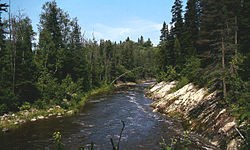
195:
194:
189:
172:
83:
61:
60:
59:
58:
57:
56:
26:
23:
17:
12:
11:
5:
1273:
1271:
1263:
1262:
1257:
1252:
1247:
1237:
1236:
1233:
1232:
1214:
1213:
1208:
1203:
1198:
1192:
1186:
1179:
1178:
1177:
1175:
1174:External links
1172:
1171:
1170:
1144:
1141:
1140:
1139:
1134:
1128:
1122:
1116:
1111:
1102:
1097:
1091:
1085:
1079:
1072:
1071:
1055:
1052:
1051:
1050:
1047:
1040:
1038:
1035:
1028:
1026:
1023:
1016:
1014:
1011:
1004:
1002:
999:
992:
988:
985:
982:
981:
954:
943:
917:
891:
890:
887:
886:
874:
865:
856:
847:
838:
826:
824:Annex G, p. 5.
812:
810:Annex G, p. 6.
803:
790:
789:
787:
784:
767:
764:
747:
744:
726:
723:
711:Saguenay River
704:Saguenay River
692:Saguenay River
684:Saguenay River
672:Saguenay River
668:
667:
664:
653:
646:
639:
635:
620:
619:
615:
612:
605:
602:
592:
591:
584:
581:
578:
575:
572:
558:Saguenay River
546:
545:
542:Saguenay River
538:
531:
524:
517:
514:lac de l'Enfer
493:
490:
488:
485:
452:
449:
403:Saguenay River
389:
388:
385:
379:
378:
367:
361:
360:
357:
353:
352:
348:
347:
344:
343:
338:
332:
331:
328:
324:
323:
320:
319:
316:
312:
311:
308:
305:
302:
301:
269:
266:
263:
262:
257:
254:
251:
250:
248:Saguenay River
245:
239:
238:
235:
234:
231:
225:
224:
192:
186:
185:
175:
169:
168:
163:
159:
158:
155:
154:
150:
149:
140:
136:
135:
130:
126:
125:
120:
116:
115:
110:
106:
105:
100:
96:
95:
91:
90:
75:
71:
70:
67:
63:
62:
50:
49:
43:
42:
41:
40:
37:
36:
28:
27:
24:
15:
13:
10:
9:
6:
4:
3:
2:
1272:
1261:
1258:
1256:
1253:
1251:
1248:
1246:
1243:
1242:
1240:
1231:
1227:
1224:
1221:
1220:
1212:
1209:
1207:
1204:
1202:
1199:
1197:
1194:
1193:
1191:
1190:
1185:
1184:OpenStreetMap
1182:
1173:
1166:
1160:
1152:
1147:
1146:
1142:
1138:
1135:
1132:
1129:
1126:
1125:Bras de Jacob
1123:
1120:
1117:
1115:
1112:
1110:
1106:
1103:
1101:
1098:
1095:
1092:
1089:
1086:
1083:
1080:
1077:
1074:
1073:
1069:
1068:Rivers portal
1058:
1053:
1044:
1039:
1032:
1027:
1020:
1015:
1008:
1003:
996:
991:
986:
969:
963:
961:
959:
955:
952:
947:
944:
931:
927:
921:
918:
906:
902:
896:
893:
881:
879:
875:
869:
866:
860:
857:
851:
848:
842:
839:
833:
831:
827:
821:
819:
817:
813:
807:
804:
798:
796:
792:
785:
783:
781:
777:
773:
765:
763:
761:
757:
753:
745:
743:
741:
740:Lac du Moulin
737:
736:Bras de Jacob
732:
724:
722:
720:
716:
712:
707:
705:
701:
697:
693:
689:
685:
681:
677:
673:
665:
662:
658:
654:
651:
647:
644:
640:
636:
633:
628:
627:
626:
624:
616:
613:
610:
609:Bras de Jacob
606:
603:
600:
599:
598:
596:
589:
585:
582:
579:
576:
573:
569:
568:
567:
565:
561:
559:
555:
551:
550:lac du Moulin
543:
539:
536:
535:Pikauba River
532:
529:
525:
522:
518:
515:
511:
510:
509:
507:
503:
502:Lac du Moulin
499:
491:
486:
484:
481:
479:
474:
470:
466:
462:
458:
450:
448:
444:
442:
438:
433:
431:
426:
424:
420:
416:
412:
408:
404:
400:
396:
386:
380:
376:
372:
371:bras de Jacob
368:
362:
358:
354:
349:
345:
342:
339:
333:
329:
325:
321:
317:
313:
309:
303:
298:
270:
264:
261:
258:
252:
249:
246:
244:
240:
236:
232:
226:
221:
193:
187:
183:
179:
176:
170:
167:
166:lac du Moulin
164:
160:
156:
151:
148:
144:
141:
137:
134:
131:
127:
124:
121:
117:
114:
111:
107:
104:
101:
97:
92:
87:
80:
76:
72:
68:
64:
47:
38:
34:
29:
20:
1188:
1187:
1180:
1150:
1143:Bibliography
972:. Retrieved
946:
934:. Retrieved
929:
920:
910:December 19,
908:. Retrieved
904:
895:
868:
859:
850:
841:
806:
769:
749:
728:
708:
680:Dubuc bridge
669:
650:autoroute 50
622:
621:
594:
593:
563:
562:
547:
495:
482:
461:Peter McLeod
454:
445:
434:
427:
398:
394:
392:
1153:. Saguenay.
700:Valin River
413:borough in
356:Tributaries
292: /
215: /
178:Lac-Pikauba
143:Lac-Pikauba
74:Native name
1239:Categories
1133:, a stream
1127:, a stream
1094:Laterrière
1076:Chicoutimi
974:26 January
780:Chicoutimi
776:Laterrière
766:Population
760:Laterrière
661:Chicoutimi
632:Laterrière
478:innu-aimun
473:Montagnais
469:flour mill
437:Chicoutimi
419:urban park
411:Chicoutimi
280:71°02′00″W
277:48°25′50″N
203:71°05′02″W
200:47°55′55″N
1159:cite book
731:watershed
725:Hydrology
715:Tadoussac
696:route 172
643:route 170
548:From the
528:route 175
487:Geography
459:built by
430:route 175
327:Discharge
66:Etymology
1226:Archived
1131:Bras Sec
1084:, a city
1082:Saguenay
1054:See also
936:March 3,
772:Saguenay
754:and the
688:Saguenay
676:Saguenay
588:Bras sec
554:Saguenay
451:Toponymy
441:Saguenay
415:Saguenay
375:bras Sec
341:Saguenay
260:Saguenay
147:Saguenay
109:Province
94:Location
884:p. 119.
746:Geology
457:Sawmill
99:Country
69:English
872:p. 16.
863:p. 26.
854:p. 23.
836:p. 25.
492:Course
421:, the
359:
330:
315:Length
162:Source
119:Region
113:Quebec
103:Canada
86:French
82:
845:p. 2.
758:from
243:Mouth
1165:link
1107:, a
976:2019
938:2011
912:2019
729:The
393:The
1196:KML
1109:ZEC
1241::
1161:}}
1157:{{
957:^
928:.
903:.
877:^
829:^
815:^
794:^
782:.
721:.
706:.
560:.
480:.
145:,
1169:.
1167:)
978:.
940:.
914:.
645:;
634:;
544:.
537:;
530:;
523:;
516:;
184:)
180:(
88:)
84:(
Text is available under the Creative Commons Attribution-ShareAlike License. Additional terms may apply.