401:
42:
296:, near a natural spring and rock outcropping from which the budding community would take its name. In 1796, Mayburn Cooper settled in the area, and was recorded in the 1816 census as a land owner. In 1829, the Rocky Springs election precinct received 90 votes. A Methodist church was erected in 1837. The first private school, Rocky Springs Academy, opened in 1838. By 1860, the community of Rocky Springs had reached a maximum population of 2,616 inhabitants, plus approximately 2,000 slaves, all living in a 25-square-mile (65 km) area. According to the NPS, at its height the town proper contained three merchants, four physicians, four teachers, three clergy and 13 artisans.
604:
59:
377:
365:
92:
389:
167:
187:
99:
66:
345:
Today, the old town site of Rocky
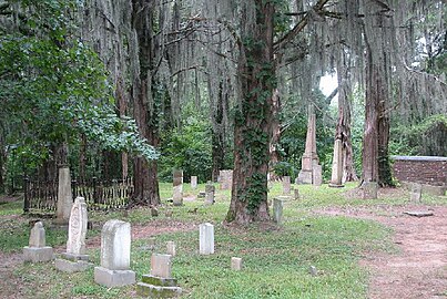
Springs can be viewed by the public during daylight hours. The Methodist church built in 1837 is the only remaining structure, which continued to hold regular Sunday services until 2010 when its congregation became too small to sustain worship. Some remnants of the
400:
350:. Placards placed along the trail by the NPS offer historical information about the town's growth and decline. A small graveyard adjacent to the church is maintained, and is the grave site of some the original settlers.
337:, while at the same time farmers were struggling with severe erosion caused by many years of poor land management. In 1930, the last store closed, and the natural spring, from which the town took its name, dried up.
308:
On May 17, 1894 a Black man, Amos Hicks, was shot and killed in his home by a group of white men. It was allegedly suspected that Hicks might have burned some buildings owned by a white man by the name of
Crawford.
744:
41:
542:
475:
535:
623:
127:
280:(mile post 54.8). The old town site can be viewed by the public during daylight hours. Rocky Springs and the surrounding area is maintained by the
749:
528:
58:
447:
663:
91:
376:
739:
253:
32:
364:
520:
754:
388:
199:
552:
273:
204:
709:
628:
593:
574:
326:
159:
433:
300:
farming was the main economic driver. A post office operated under the name Rocky
Springs from 1819 to 1932.
691:
686:
615:
465:
Rootsweb.ancestry.com, Claiborne County (part of the MSGenWeb): Historic Rocky
Springs Claiborne County, MS
658:
633:
293:
281:
277:
716:
238:
292:
Rocky
Springs was established in the late 1700s as a popular watering place for travelers along the
668:
653:
643:
318:
463:
228:
512:
434:
U.S. Geological Survey
Geographic Names Information System: Rocky Springs, Mississippi
733:
172:
330:
567:
346:
town can be viewed along a short loop trail, including a post office safe and a
334:
192:
678:
322:
269:
179:
142:
129:
219:
329:. In 1878 the remaining inhabitants of Rocky Springs faced an outbreak of
603:
347:
297:
333:. Later, valuable cotton crops were destroyed by an infestation of
245:
224:
585:
524:
602:
325:
forces passed through the area during the advance on nearby
317:
The community of Rocky
Springs began to decline during the
497:"MISSISSIPPI MATTERS". People's Banner (MS). May 17, 1894.
406:
Ruins of the Red Tavern of the
Natchez Trace photographed
745:
Former populated places in
Claiborne County, Mississippi
276:, United States, between Old Port Gibson Road and the
677:
642:
614:
584:
449:
Natcheztracetravel.com, Rocky
Springs Natchez Trace
252:
235:
218:
210:
198:
178:
158:
23:
607:Map of Mississippi highlighting Claiborne County
536:
8:
543:
529:
521:
20:
18:Ghost town in Mississippi, United States
508:
506:
504:
459:
457:
455:
426:
360:
251:
217:
209:
157:
122:
50:
38:
443:
441:
234:
197:
177:
98:
65:
7:
394:Post office safe and covered cistern
551:Municipalities and communities of
14:
111:Rocky Springs (the United States)
399:
387:
375:
363:
185:
165:
97:
90:
64:
57:
40:
46:Marker at site of Rocky Springs
750:Lynching deaths in Mississippi
382:Rocky Springs Methodist Church
1:
554:Claiborne County, Mississippi
407:
274:Claiborne County, Mississippi
272:and historic site located in
114:Show map of the United States
771:
740:Ghost towns in Mississippi
478:. Jim Forte Postal History
25:Rocky Springs, Mississippi
705:
600:
565:
123:
78:Location of Rocky Springs
51:
39:
30:
624:Alcorn State University
214:95 m (312 ft)
81:Show map of Mississippi
755:Springs of Mississippi
608:
370:Rocky Springs Cemetery
606:
282:National Park Service
278:Natchez Trace Parkway
237: • Summer (
143:32.08889°N 90.81500°W
718:United States portal
148:32.08889; -90.81500
139: /
711:Mississippi portal
609:
476:"Claiborne County"
727:
726:
514:Civilwaralbum.com
294:old Natchez Trace
263:
262:
762:
719:
712:
605:
577:
570:
560:
555:
545:
538:
531:
522:
515:
510:
499:
498:
494:
488:
487:
485:
483:
472:
466:
461:
450:
445:
436:
431:
412:
409:
403:
391:
379:
367:
321:, at which time
242:
191:
189:
188:
171:
169:
168:
154:
153:
151:
150:
149:
144:
140:
137:
136:
135:
132:
115:
101:
100:
94:
82:
68:
67:
61:
44:
21:
770:
769:
765:
764:
763:
761:
760:
759:
730:
729:
728:
723:
717:
710:
701:
673:
645:
638:
610:
598:
580:
575:
568:
561:
558:
553:
549:
519:
518:
511:
502:
496:
495:
491:
481:
479:
474:
473:
469:
462:
453:
446:
439:
432:
428:
423:
418:
417:
416:
413:
410:
404:
395:
392:
383:
380:
371:
368:
356:
343:
315:
306:
290:
236:
186:
184:
166:
164:
147:
145:
141:
138:
133:
130:
128:
126:
125:
119:
118:
117:
116:
113:
112:
109:
108:
107:
106:
102:
85:
84:
83:
80:
79:
76:
75:
74:
73:
69:
47:
35:
26:
19:
12:
11:
5:
768:
766:
758:
757:
752:
747:
742:
732:
731:
725:
724:
722:
721:
714:
706:
703:
702:
700:
699:
694:
689:
683:
681:
675:
674:
672:
671:
666:
661:
656:
650:
648:
640:
639:
637:
636:
631:
626:
620:
618:
612:
611:
601:
599:
597:
596:
590:
588:
582:
581:
566:
563:
562:
550:
548:
547:
540:
533:
525:
517:
516:
500:
489:
467:
451:
437:
425:
424:
422:
419:
415:
414:
405:
398:
396:
393:
386:
384:
381:
374:
372:
369:
362:
359:
358:
357:
355:
352:
342:
339:
314:
311:
305:
302:
289:
286:
261:
260:
257:
250:
249:
243:
233:
232:
222:
216:
215:
212:
208:
207:
202:
196:
195:
182:
176:
175:
162:
156:
155:
121:
120:
110:
104:
103:
96:
95:
89:
88:
87:
86:
77:
71:
70:
63:
62:
56:
55:
54:
53:
52:
49:
48:
45:
37:
36:
31:
28:
27:
24:
17:
13:
10:
9:
6:
4:
3:
2:
767:
756:
753:
751:
748:
746:
743:
741:
738:
737:
735:
720:
715:
713:
708:
707:
704:
698:
697:Rocky Springs
695:
693:
690:
688:
685:
684:
682:
680:
676:
670:
667:
665:
662:
660:
657:
655:
652:
651:
649:
647:
641:
635:
632:
630:
627:
625:
622:
621:
619:
617:
613:
595:
592:
591:
589:
587:
583:
579:
578:
571:
564:
559:United States
556:
546:
541:
539:
534:
532:
527:
526:
523:
513:
509:
507:
505:
501:
493:
490:
477:
471:
468:
464:
460:
458:
456:
452:
448:
444:
442:
438:
435:
430:
427:
420:
402:
397:
390:
385:
378:
373:
366:
361:
353:
351:
349:
340:
338:
336:
332:
328:
324:
320:
312:
310:
303:
301:
299:
295:
287:
285:
283:
279:
275:
271:
267:
266:Rocky Springs
258:
255:
247:
244:
240:
230:
229:Central (CST)
226:
223:
221:
213:
206:
203:
201:
194:
183:
181:
174:
173:United States
163:
161:
152:
124:Coordinates:
105:Rocky Springs
93:
72:Rocky Springs
60:
43:
34:
29:
22:
16:
696:
573:
492:
480:. Retrieved
470:
429:
344:
335:boll weevils
331:yellow fever
316:
307:
291:
265:
264:
15:
679:Ghost towns
646:communities
629:Hermanville
594:Port Gibson
576:Port Gibson
569:County seat
411: 1938
341:Present day
327:Port Gibson
193:Mississippi
146: /
734:Categories
692:Grand Gulf
687:Bruinsburg
421:References
270:ghost town
256:feature ID
134:90°48′54″W
131:32°05′20″N
33:Ghost town
319:Civil War
220:Time zone
211:Elevation
205:Claiborne
659:Carlisle
634:Pattison
304:Lynching
482:May 14,
354:Gallery
348:cistern
313:Decline
288:History
160:Country
669:Russum
664:Peyton
654:Alcorn
298:Cotton
259:692184
200:County
190:
170:
644:Other
323:Union
268:is a
248:(CDT)
246:UTC-5
225:UTC-6
180:State
616:CDPs
586:City
484:2020
254:GNIS
239:DST
736::
572::
557:,
503:^
454:^
440:^
408:c.
284:.
544:e
537:t
530:v
486:.
241:)
231:)
227:(
Text is available under the Creative Commons Attribution-ShareAlike License. Additional terms may apply.