45:
212:
255:
29:
334:
52:
330:. At times, the algae form a visible surface scum, and their high concentration results in large swings in the dissolved oxygen content of the water, culminating in a depletion of oxygen when the population finally crashes. This annual algae bloom, because of its size and potential toxicity, is considered problematic for water quality and fish survival.
345:
in the summer and fall. This deficit is caused by the high oxygen consumption of decaying algae that occurs during that time of year. The large algae population, which withdraws carbon dioxide from the water, also raises the pH to very high levels. The pH is typically greater than 9 throughout the
219:
Rodeo Lagoon empties into the
Pacific Ocean when the water level reaches a high enough level to erode through the sand bar. This high water level usually occurs in the winter months. The outlet channel, shown at left looking southeast towards Rodeo Lagoon, is spanned by a pedestrian bridge that
223:
The depth, surface area, and volume of the lagoon all vary depending on the configuration of the sand berm (high or low) and rainfall (wet or dry). Depths in the center range from less than 1.5 metres (4.9 ft) in a dry summer to nearly 3 metres (9.8 ft) in a wet winter.
378:. In 1937, the Army constructed a road crossing at the east of the lagoon, which resulted in a reduction in the lagoon's size as the area upstream of the crossing gradually turned into a freshwater marsh. The lagoon is now about 80% of its original size.
271:. It also provides habitat to many species of migrating waterfowl. Resident fish include the threespine stickleback and prickly sculpin in addition to the tidewater goby. A family of river otters also makes frequent use of the lagoon, and includes
227:
Tides do not have a significant effect on the circulation of water in Rodeo Lagoon. Instead, the circulation of water in Rodeo Lagoon is driven almost entirely by the wind. Since the Marin
Headlands are often quite windy, it is not unusual to see
386:
Recreation is not allowed on or in Rodeo Lagoon because of water quality and wildlife concerns. However, the lagoon and surrounding area is an excellent place for wildlife viewing, particularly birding and watching the playful river otters.
220:
provides access to Rodeo Beach. Like many other coastal lagoons in
California, the outlet becomes completely blocked by a sand bar during the dry summer months, resulting in negligible exchange between the lagoon and ocean during that time.
203:. Rodeo Lagoon stretches approximately 900 metres (3,000 ft) by 250 metres (820 ft), and is about 2 metres (6.6 ft) deep at its maximum depth. It covers a surface area of about 15 hectares (37 acres).
362:
following the last glacial period. The bed of the lagoon is covered by viscous black mud that is high in organic content, except at the east and west ends, where non-organic sediment can be found.
867:
857:
506:
862:
847:
87:
414:
247:(psu) over the course of the year. However, water near the bottom of the lagoon is often much saltier, reaching levels as high as 25 psu. The bowl-shaped
501:
275:
in their summer diet. The lagoon is ringed by emergent aquatic vegetation, such as willows and cattail, and has submerged aquatic vegetation like sago
449:
773:
672:
180:
581:
533:
44:
717:
806:
566:
852:
491:
606:
837:
496:
798:
712:
793:
576:
611:
778:
682:
561:
73:
403:
526:
342:
358:
The lagoon is located within the geologically complex Marin
Headlands and fills a valley drowned by recent
752:
591:
251:
of the lagoon traps this dense, salty water and prevents it from quickly draining back out in the ocean.
571:
326:
The population of phytoplankton described above is extremely high in the summer, a condition known as
632:
586:
229:
842:
811:
616:
596:
556:
464:
816:
519:
211:
692:
657:
601:
425:
652:
176:
370:
Rodeo Lagoon was mostly unaltered until the area was developed by the U.S. military into
254:
28:
742:
647:
637:
371:
359:
327:
268:
467:
Wetland
Habitat Changes in the Rodeo Lagoon Watershed, Marin County, CA, October 2004.
428:, 1996, Langmuir circulations on Rodeo Lagoon, Monthly Weather Review 124(2), 341-342.
831:
788:
757:
687:
667:
642:
315:
280:
272:
196:
119:
702:
697:
333:
184:
747:
722:
707:
347:
288:
200:
737:
727:
662:
542:
375:
248:
188:
102:
89:
677:
318:, capable of releasing the toxins microcystin and nodularin into the water.
301:
292:
276:
244:
240:
192:
476:
404:
U.S. Geological Survey
Geographic Names Information System: Rodeo Lagoon
233:
284:
172:
124:
332:
253:
210:
783:
515:
440:, Otter Chaos at Rodeo Lagoon, Bay Nature, July–September 2007
511:
33:
Rodeo Lagoon, viewed on a windy day from its southeast corner
437:
267:
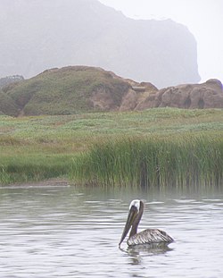
Rodeo Lagoon provides habitat to a protected species, the
341:
Rodeo Lagoon typically suffers from an oxygen deficit or
766:
625:
549:
507:
Golden Gate
National Recreation Area-related topics
158:
150:
142:
134:
130:
118:
79:
69:
21:
452:Geology of the Golden Gate Headlands Field Guide
80:
527:
279:and widgeon grass in the shallow areas. The
8:
239:Rodeo Lagoon is a brackish water body, with
502:List of lakes in the San Francisco Bay Area
243:in most of the lagoon ranging from 2 to 10
534:
520:
512:
18:
258:A brown pelican floating in Rodeo Lagoon
16:Lagoon in Marin County, California, U.S.
396:
460:
458:
236:of foam on the surface of the lagoon.
868:Estuaries of Marin County, California
774:Bolinas-Stinson Union School District
7:
858:Golden Gate National Recreation Area
673:Golden Gate National Recreation Area
181:Golden Gate National Recreation Area
51:
863:Lakes of the San Francisco Bay Area
848:Lagoons of Marin County, California
337:Cyanobacterial scum in Rodeo Lagoon
718:Rancho Punta de los Reyes Sobrante
14:
807:Shoreline Unified School District
195:water body is separated from the
50:
43:
27:
465:San Francisco Estuary Institute
157:
149:
141:
133:
215:Outlet channel of Rodeo Lagoon
1:
713:Point Reyes National Seashore
68:
794:North Pacific Coast Railroad
884:
138:900 metres (3,000 ft)
199:by a sand bar that forms
38:
26:
779:California State Route 1
245:practical salinity units
146:250 metres (820 ft)
74:Marin County, California
853:Estuaries of California
492:Estuaries of California
477:Birding in Marin County
183:, which is in southern
753:Tomales Bay State Park
338:
297:Microcystis aeruginosa
259:
216:
162:2 metres (6.6 ft)
154:15 hectares (37 acres)
103:37.83083°N 122.53111°W
838:Lagoons of California
497:Lagoons of California
450:National Park Service
336:
257:
214:
633:Audubon Canyon Ranch
230:Langmuir circulation
207:Inflows and outflows
108:37.83083; -122.53111
812:Tomales High School
626:Geography and parks
607:Point Reyes Station
314:are types of toxic
283:community includes
99: /
817:West Marin Citizen
339:
260:
217:
825:
824:
801:Point Reyes Light
693:Nicasio Reservoir
658:Copper Mine Gulch
166:
165:
875:
536:
529:
522:
513:
479:
474:
468:
462:
453:
447:
441:
435:
429:
423:
417:
412:
406:
401:
179:division of the
114:
113:
111:
110:
109:
104:
100:
97:
96:
95:
92:
82:
54:
53:
47:
31:
19:
883:
882:
878:
877:
876:
874:
873:
872:
828:
827:
826:
821:
762:
653:Centissima Reef
621:
545:
540:
488:
483:
482:
475:
471:
463:
456:
448:
444:
436:
432:
424:
420:
413:
409:
402:
398:
393:
384:
368:
356:
324:
308:Microcystis sp.
265:
209:
177:Marin Headlands
175:located in the
107:
105:
101:
98:
93:
90:
88:
86:
85:
65:
64:
63:
62:
61:
60:
59:
55:
34:
17:
12:
11:
5:
881:
879:
871:
870:
865:
860:
855:
850:
845:
840:
830:
829:
823:
822:
820:
819:
814:
809:
804:
796:
791:
786:
781:
776:
770:
768:
764:
763:
761:
760:
755:
750:
745:
743:Tennessee Cove
740:
735:
730:
725:
720:
715:
710:
705:
700:
695:
690:
685:
680:
675:
670:
665:
660:
655:
650:
648:Bonita Channel
645:
640:
638:Bolinas Lagoon
635:
629:
627:
623:
622:
620:
619:
614:
609:
604:
599:
594:
589:
584:
579:
577:Inverness Park
574:
569:
564:
559:
553:
551:
547:
546:
541:
539:
538:
531:
524:
516:
510:
509:
504:
499:
494:
487:
484:
481:
480:
469:
454:
442:
430:
418:
407:
395:
394:
392:
389:
383:
380:
372:Fort Cronkhite
367:
364:
360:sea level rise
355:
352:
328:eutrophication
323:
322:Eutrophication
320:
291:, flagellated
273:brown pelicans
269:tidewater goby
264:
261:
208:
205:
164:
163:
160:
156:
155:
152:
148:
147:
144:
140:
139:
136:
132:
131:
128:
127:
122:
116:
115:
83:
77:
76:
71:
67:
66:
57:
56:
49:
48:
42:
41:
40:
39:
36:
35:
32:
24:
23:
15:
13:
10:
9:
6:
4:
3:
2:
880:
869:
866:
864:
861:
859:
856:
854:
851:
849:
846:
844:
841:
839:
836:
835:
833:
818:
815:
813:
810:
808:
805:
803:
802:
797:
795:
792:
790:
789:Marin Organic
787:
785:
782:
780:
777:
775:
772:
771:
769:
765:
759:
758:Tomales Point
756:
754:
751:
749:
746:
744:
741:
739:
736:
734:
731:
729:
726:
724:
721:
719:
716:
714:
711:
709:
706:
704:
701:
699:
696:
694:
691:
689:
688:Nicasio Creek
686:
684:
681:
679:
676:
674:
671:
669:
668:Drakes Estero
666:
664:
661:
659:
656:
654:
651:
649:
646:
644:
643:Bolinas Ridge
641:
639:
636:
634:
631:
630:
628:
624:
618:
615:
613:
612:Stinson Beach
610:
608:
605:
603:
600:
598:
595:
593:
590:
588:
585:
583:
580:
578:
575:
573:
570:
568:
565:
563:
560:
558:
555:
554:
552:
548:
544:
537:
532:
530:
525:
523:
518:
517:
514:
508:
505:
503:
500:
498:
495:
493:
490:
489:
485:
478:
473:
470:
466:
461:
459:
455:
451:
446:
443:
439:
434:
431:
427:
422:
419:
416:
411:
408:
405:
400:
397:
390:
388:
381:
379:
377:
373:
365:
363:
361:
353:
351:
349:
344:
335:
331:
329:
321:
319:
317:
316:cyanobacteria
313:
312:Nodularia sp.
309:
305:
303:
298:
294:
290:
286:
282:
281:phytoplankton
278:
274:
270:
262:
256:
252:
250:
246:
242:
237:
235:
231:
225:
221:
213:
206:
204:
202:
198:
197:Pacific Ocean
194:
190:
186:
182:
178:
174:
171:is a coastal
170:
161:
153:
145:
137:
129:
126:
123:
121:
117:
112:
84:
78:
75:
72:
46:
37:
30:
25:
20:
800:
733:Rodeo Lagoon
732:
703:Pirates Cove
698:Olema Valley
562:Dillon Beach
472:
445:
433:
421:
410:
399:
385:
369:
357:
340:
325:
311:
307:
300:
296:
289:chlorophytes
266:
238:
226:
222:
218:
185:Marin County
169:Rodeo Lagoon
168:
167:
151:Surface area
58:Rodeo Lagoon
22:Rodeo Lagoon
748:Tomales Bay
723:Rodeo Beach
708:Point Reyes
683:Kent Island
426:A. J. Szeri
348:algae bloom
201:Rodeo Beach
135:Max. length
106: /
94:122°31′52″W
81:Coordinates
843:West Marin
832:Categories
738:Sears Rock
728:Rodeo Cove
663:Drakes Bay
592:Muir Beach
543:West Marin
391:References
382:Recreation
376:Fort Barry
249:bathymetry
241:salinities
189:California
159:Max. depth
143:Max. width
91:37°49′51″N
767:Community
678:Gull Rock
582:Lagunitas
572:Inverness
304:spumigena
302:Nodularia
587:Marshall
550:Villages
486:See also
438:J. Laws
293:protozoa
277:pondweed
263:Wildlife
234:windrows
193:brackish
191:. This
70:Location
617:Tomales
597:Nicasio
567:Dogtown
557:Bolinas
366:History
354:Geology
346:summer
343:hypoxia
285:diatoms
299:, and
173:lagoon
125:lagoon
602:Olema
232:form
799:The
784:KWMR
415:USGS
374:and
310:and
120:Type
306:.
834::
457:^
350:.
295:,
287:,
187:,
535:e
528:t
521:v
Text is available under the Creative Commons Attribution-ShareAlike License. Additional terms may apply.