303:
491:
46:
2134:
236:
243:
228:
221:
2117:
651:. There were 960 households, comprising 1,407 males and 1,482 females, giving a sex ratio of 0.95 males per female. The median age was 39.8 years (compared with 37.4 years nationally), with 558 people (19.3%) aged under 15 years, 561 (19.4%) aged 15 to 29, 1,368 (47.4%) aged 30 to 64, and 399 (13.8%) aged 65 or older.
521:, John Knight, began developing the land to sell as a subdivision. Construction on Rothesay Bay Road had begun by 1912, and the land was subdivided for sale in 1915 and 1916. While many historical sources describe Knight naming the subdivision after his hometown in Scotland, Knight did not come from
695:
Of those at least 15 years old, 876 (37.6%) people had a bachelor's or higher degree, and 165 (7.1%) people had no formal qualifications. The median income was $ 43,200, compared with $ 31,800 nationally. 708 people (30.4%) earned over $ 70,000 compared to 17.2% nationally. The employment status of
528:
A small settlement of holiday homes developed during the 1920s, but even into the 1950s the area was sparsely populated and rural. By 1945, ten families had permanently settled at
Rothesay Bay, and a close-knit community developed. The families used the Rothesay Bay beach as a common area to
510:. The purchase involved some iwi with customary interests in the area, such as Ngāti Paoa, other Marutūāhu iwi and Ngāi Tai ki Tāmaki, but not others, such as Te Kawerau ā Maki or Ngāti Rango. The Crown spent until 1873 rectifying this sale, by making further deals with stakeholders.
545:, a large rural county north and west of the city of Auckland. In 1954, the area split from the county, forming the East Coast Bays Borough Council, which became East Coast Bays City in 1975. In 1989, the city was merged into the
996:
1180:
Murdoch, Graeme (1990). "Nga Tohu o
Waitakere: the Maori Place Names of the Waitakere River Valley and its Environs; their Background History and an Explanation of their Meaning". In Northcote-Bade, James (ed.).
1151:
1119:
1060:
464:
and the North Shore. After periods of conflict, peace had been reached by the 1790s. The earliest contact with
Europeans began in the late 18th century, which caused many Tāmaki Māori to die of
1283:
45:
1994:
2068:
525:. The origin of the name is unknown, but it may have come from the Scottish song "Sweet Rothesay Bay", which was referenced in some of the advertising material for the suburb.
341:, which can be seen in the cliffs along the coast. Prior to human settlement, the inland Rothesay Bay area was primarily a northern broadleaf podocarp forest, dominated by
1028:
1347:
576:
Rothesay Bay covers 0.86 km (0.33 sq mi) and had an estimated population of 3,050 as of June 2023, with a population density of 3,547 people per km.
1603:
517:
diggers, and small sections of land were part of cattle farms owned by the
Vaughan family and by W. Hart. In the 1910s, Scottish immigrant and resident of
400:. While the poor soils around the East Coast Bays hindered dense settlement, traditional resources in the area included fish, shellfish and marine birds.
1671:
1853:
2041:
881:
1821:
1319:
1272:
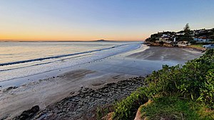
1743:
123:
2105:
964:
935:
896:
1417:
1214:
959:
Veart, Dave (2018). The Māori
Archaeology of Te Raki Paewhenua/North Shore (Report). Auckland North Community and Development. p. 10.
71:
513:
Unlike the surrounding bays, most of
Rothesay Bay was left as scrubland in the 19th century. The main visitors to the area were itinerant
1500:
396:
migratory canoe and ancestors of figures such as
Taikehu and Peretū. Many of the Tāmaki Māori people of the North Shore identified as
1651:
1377:
1190:
696:
those at least 15 was that 1,191 (51.2%) people were employed full-time, 420 (18.0%) were part-time, and 66 (2.8%) were unemployed.
755:
302:
1035:
676:
Although some people chose not to answer the census's question about religious affiliation, 57.7% had no religion, 33.9% were
2020:
1795:
565:
138:
1446:
1089:
2015:
1984:
1846:
561:
148:
111:
2159:
677:
415:, including those of the North Shore. After Maki's death, his sons settled different areas of his lands, creating new
533:, a pillbox was installed at the Rothesay Bay Esplanade, and gun emplacements were constructed on the nearby cliffs.
2062:
1061:
Cultural Values
Assessment Report to New Zealand Transport Agency for Northern Corridor Improvements Project (NCI)
2164:
1783:
1639:
490:
2169:
2028:
1839:
1678:
1320:"Ngāti Pāoa and the Trustees of the Ngāti Pāoa Iwi Trust and The Crown Deed of Settlement of Historical Claims"
732:
546:
420:
358:
315:
181:
1056:
442:
2035:
1881:
709:
689:
681:
663:
648:
644:
640:
319:
204:
1748:
783:
1989:
1587:
1567:
1496:
1424:
1413:
1326:
1311:
1221:
1210:
927:
787:
499:
366:
350:
1897:
346:
258:
2123:
1917:
1922:
1492:
1271:
Ngāi Tai Ki Tāmaki and the
Trustees of the Ngāi Tai Ki Tāmaki Trust and the Crown (7 November 2015).
685:
667:
412:
362:
331:
2057:
1932:
835:
713:
518:
338:
411:, likely sometime in the 17th century. Maki conquered and unified many the Tāmaki Māori tribes as
1825:
1582:
1029:
Penlink
Cultural & Environmental Design Framework: Penlink Cultural and Environmental Context
446:
387:
365:
trees were a major feature of the coastline. During the 19th century, the area was dominated by
1562:
2090:
1968:
1791:
1722:
1647:
1453:
1409:
1378:"Cultural Values Assessment for the Warkworth North Structure Plan and Associated Development"
1206:
1186:
960:
931:
892:
557:
438:
354:
342:
2074:
2010:
1712:
1614:
1388:
1354:
1158:
1003:
941:
888:
550:
542:
475:
128:
1604:
North Shore heritage – North Shore area studies and scheduled items list: volume 2 parts 6+
470:, respiratory diseases. During the early 1820s, most Māori of the North Shore fled for the
1862:
408:
383:
311:
287:
1831:
1090:
Cultural Values Assessment for America's Cup 36 - Wynyard and Hobson Planning Application
659:
453:
431:. Maraeariki's daughter Kahu succeeded him, and she is the namesake of the North Shore,
1963:
1937:
1246:
1120:
Cultural Impact Assessment for the NZ Transport Agency's Northern Corridor Improvements
428:
424:
404:
392:
2153:
1886:
1315:
728:
705:
457:
1958:
1902:
1571:. Vol. XLIX, no. 15066. 8 August 1912. p. 4 – via Papers Past.
724:
530:
461:
327:
250:
51:
1591:. Vol. VII, no. 15905. 30 April 1915. p. 2 – via Papers Past.
655:
673:
The percentage of people born overseas was 43.0, compared with 27.1% nationally.
1907:
1130:
1067:
670:, and 2.9% other ethnicities. People may identify with more than one ethnicity.
479:
323:
291:
263:
2086:
1912:
1891:
507:
397:
199:
1726:
851:
437:("The Greater Lands of Kahu"), Many of the iwi of the North Shore, including
334:. An unnamed stream flows north-east through the suburb to the Hauraki Gulf.
86:
73:
945:
808:
514:
55:
1717:
1700:
1866:
704:
A popular public walkway passes through coastal Rothesay Bay, connecting
522:
503:
283:
116:
2140:
386:
began around the 13th or 14th centuries. The North Shore was settled by
593:
471:
416:
1942:
1701:"The planning framework for Auckland 'super city': an insider's view"
279:
36:
502:
purchased the Mahurangi and Omaha blocks; an area that spanned from
489:
301:
213:
1306:
1304:
2069:
The Corelli International Academic School of the Arts (defunct)
1835:
2099:
778:
776:
1746:. Statistics New Zealand. March 2020. Rothesay Bay (119000).
588:
556:
Within the Auckland Council, Rothesay Bay is a part of the
460:
had expanded their influence to include the islands of the
1545:
1543:
1541:
1539:
2089:
is located outside of the East Coast Bays subdivision of
1526:
1524:
1522:
1520:
568:, which elects two councillors to the Auckland Council.
482:. Most people had returned by the late 1820s and 1830s.
1472:
1470:
541:
From 1876 until 1954, the area was administered by the
1995:
Sir Peter Blake Marine Education and Recreation Centre
978:
976:
882:
North Shore Heritage - Thematic Review Report Volume 1
712:
in the north. The walkway passes sections of exposed
1185:. West Auckland Historical Society. pp. 13–14.
995:
Pishief, Elizabeth; Shirley, Brendan (August 2015).
2050:
2003:
1977:
1951:
1874:
1633:
1631:
1495:; The Trustees of Te Kawerau Iwi Settlement Trust;
834:Harriss, Gavin (March 2022). "NZ Topo Map" (Map).
180:
172:
167:
159:
154:
144:
134:
122:
110:
102:
27:
917:
915:
735:grew up in Rothesay Bay until he was 6 years old.
647:, and an increase of 273 people (10.4%) since the
441:, Ngāti Maraeariki, Ngāti Kahu, Ngāti Poataniwha,
1776:An Almost Complete History of the East Coast Bays
875:
873:
1665:
1663:
1487:
1485:
50:The beach at Rothesay Bay at low tide, with the
1638:Reidy, Jade (2009). "How the West Was Run". In
290:region. The suburb is roughly the same size as
1738:
1736:
1266:
1264:
639:Rothesay Bay had a population of 2,886 at the
1847:
880:Heritage Consultancy Services (1 July 2011).
643:, an increase of 180 people (6.7%) since the
8:
1744:"Statistical area 1 dataset for 2018 Census"
579:
478:due to the threat of war parties during the
465:
432:
337:The soil is primarily formed from clay and
1854:
1840:
1832:
1022:
1020:
578:
195:
24:
1716:
1418:"Deed of Settlement of Historical Claims"
1240:
1238:
1215:"Deed of Settlement of Historical Claims"
419:. His younger son Maraeariki settled the
1501:"Deed of Settlement of Historical Claim"
1447:The Crown, Maori and Mahurangi 1840-1881
549:. North Shore City was amalgamated into
2112:
1749:2018 Census place summary: Rothesay Bay
1348:"Wenderholm Regional Park: Our History"
1273:"Deed of settlement schedule documents"
982:
744:
427:, who based himself at the head of the
179:
166:
153:
101:
66:
62:
42:
1549:
784:"Population estimate tables - NZ.Stat"
750:
748:
560:local government area governed by the
390:, including people descended from the
1476:
1289:from the original on 13 February 2020
294:, the suburb to the immediate south.
171:
158:
143:
133:
121:
109:
7:
1530:
1602:Lutz, Heike; Chan, Theresa (2011).
449:, can trace their lineage to Kahu.
403:The warrior Maki migrated from the
2029:North Shore City Council (defunct)
1646:. Random House. pp. 238–239.
1385:Manuhiri Kaitiaki Charitable Trust
1127:Manuhiri Kaitiaki Charitable Trust
14:
2036:Rodney District Council (defunct)
1788:From Tamaki-makau-rau to Auckland
1183:West Auckland Remembers, Volume 1
1097:Te Kawerau Iwi Tribunal Authority
2132:
2115:
1807:Early History of East Coast Bays
1583:"Page 2 Advertisements Column 5"
1152:"Waitākere Ranges Heritage Area"
997:"Waikōwhai Coast Heritage Study"
654:Ethnicities were 79.4% European/
241:
234:
226:
219:
44:
1769:. East Coast Bays City Council.
1036:Waka Kotahi NZ Transport Agency
922:Janssen, Peter (January 2021).
310:Rothesay Bay is located in the
22:Suburb in Auckland, New Zealand
1644:West: The History of Waitakere
1088:Mossman, Sarah (August 2018).
858:. Land Information New Zealand
815:. Land Information New Zealand
692:and 1.0% had other religions.
1:
2016:Hibiscus and Bays Local Board
1985:Long Bay-Okura Marine Reserve
1790:. Auckland University Press.
1611:Heritage Consultancy Services
1249:. Restore Hibiscus & Bays
1118:McKenzie, Fiona (June 2016).
562:Hibiscus and Bays Local Board
494:Rothesay Bay Beach circa 1968
407:to his ancestral home in the
242:
220:
149:Hibiscus and Bays Local Board
1670:Mace, Tania (October 2006).
1445:Rigby, Barry (August 1998).
1376:McKenzie, Fiona (May 2017).
235:
227:
1822:Photographs of Rothesay Bay
1245:Whaanga, Mel (March 2022).
326:. The bay looks out to the
163:86 ha (213 acres)
2186:
2063:East Coast Bays Barracudas
2042:East Coast Bays electorate
1978:Facilities and attractions
1672:"Browns Bay Heritage Walk"
306:Rothesay Bay beach in 1963
2083:
1774:Sheehan, Vanessa (2019).
632:
606:—
452:By the 18th century, the
67:
63:
43:
34:
1699:Blakeley, Roger (2015).
1679:North Shore City Council
756:"ArcGIS Web Application"
733:Harry Potter film series
382:Māori settlement of the
1767:ECB – the Years to 1989
760:statsnz.maps.arcgis.com
641:2018 New Zealand census
1990:Long Bay Regional Park
1805:Willis, Jenny (2018).
1718:10.26686/pq.v11i4.4572
1588:The New Zealand Herald
1568:The New Zealand Herald
1425:New Zealand Government
1327:New Zealand Government
1312:New Zealand Government
1222:New Zealand Government
928:New Holland Publishers
924:Greater Auckland Walks
837:Rothesay Bay, Auckland
788:Statistics New Zealand
564:. It is a part of the
495:
466:
433:
307:
2104:at Knowledge (XXG)'s
1828:heritage collections.
1642:; Kerr, Ruth (eds.).
1247:"He taonga o te rohe"
856:New Zealand Gazetteer
813:New Zealand Gazetteer
580:Historical population
493:
305:
1765:Cass, David (1989).
1499:(22 February 2014).
434:Te Whenua Roa o Kahu
332:Coromandel Peninsula
2160:Suburbs of Auckland
2058:East Coast Bays AFC
1952:Geographic features
1826:Auckland Libraries'
1131:NZ Transport Agency
1068:NZ Transport Agency
714:Waitemata sandstone
581:
486:European settlement
339:Waitemata sandstone
83: /
1809:(Second ed.).
1057:Ngāi Tai ki Tāmaki
553:in November 2010.
529:socialise. During
496:
443:Ngāi Tai Ki Tāmaki
308:
173: • Total
87:36.721°S 174.751°E
2097:
2096:
2091:Hibiscus and Bays
1640:Macdonald, Finlay
1552:, pp. 18–19.
1533:, pp. 11–12.
1493:Te Kawerau ā Maki
1454:Waitangi Tribunal
1318:(20 March 2021).
966:978-0-9941358-4-1
937:978-1-86966-516-6
930:. p. 43-44.
898:978-1-927169-21-6
720:Notable residents
637:
636:
558:Hibiscus and Bays
413:Te Kawerau ā Maki
271:
270:
192:
191:
160: • Land
2177:
2165:Bays of Auckland
2145:
2137:
2136:
2135:
2128:
2120:
2119:
2118:
2108:
2075:Long Bay College
2011:Auckland Council
1875:Populated places
1856:
1849:
1842:
1833:
1810:
1801:
1779:
1770:
1751:
1747:
1740:
1731:
1730:
1720:
1705:Policy Quarterly
1696:
1690:
1689:
1687:
1685:
1676:
1667:
1658:
1657:
1635:
1626:
1625:
1623:
1621:
1615:Auckland Council
1608:
1599:
1593:
1592:
1579:
1573:
1572:
1559:
1553:
1547:
1534:
1528:
1515:
1514:
1512:
1510:
1505:
1489:
1480:
1474:
1465:
1464:
1462:
1460:
1451:
1442:
1436:
1435:
1433:
1431:
1422:
1406:
1400:
1399:
1397:
1395:
1389:Auckland Council
1382:
1373:
1367:
1366:
1364:
1362:
1355:Auckland Council
1352:
1344:
1338:
1337:
1335:
1333:
1324:
1308:
1299:
1298:
1296:
1294:
1288:
1277:
1268:
1259:
1258:
1256:
1254:
1242:
1233:
1232:
1230:
1228:
1219:
1203:
1197:
1196:
1177:
1171:
1170:
1168:
1166:
1159:Auckland Council
1156:
1148:
1142:
1141:
1139:
1137:
1124:
1115:
1109:
1108:
1106:
1104:
1094:
1085:
1079:
1078:
1076:
1074:
1065:
1053:
1047:
1046:
1044:
1042:
1033:
1024:
1015:
1014:
1012:
1010:
1004:Auckland Council
1001:
992:
986:
980:
971:
970:
956:
950:
949:
919:
910:
909:
907:
905:
889:Auckland Council
886:
877:
868:
867:
865:
863:
848:
842:
841:
831:
825:
824:
822:
820:
805:
799:
798:
796:
794:
780:
771:
770:
768:
766:
752:
595:
590:
582:
551:Auckland Council
547:North Shore City
543:Waitemata County
537:Local government
469:
436:
245:
244:
238:
237:
233:
230:
229:
223:
222:
196:
129:Auckland Council
98:
97:
95:
94:
93:
92:-36.721; 174.751
88:
84:
81:
80:
79:
76:
48:
25:
2185:
2184:
2180:
2179:
2178:
2176:
2175:
2174:
2170:East Coast Bays
2150:
2149:
2148:
2138:
2133:
2131:
2121:
2116:
2114:
2111:
2107:sister projects
2106:
2098:
2093:
2079:
2046:
1999:
1973:
1947:
1870:
1863:East Coast Bays
1860:
1818:
1813:
1804:
1798:
1784:Stone, R. C. J.
1782:
1773:
1764:
1760:
1755:
1754:
1742:
1741:
1734:
1698:
1697:
1693:
1683:
1681:
1674:
1669:
1668:
1661:
1654:
1637:
1636:
1629:
1619:
1617:
1606:
1601:
1600:
1596:
1581:
1580:
1576:
1561:
1560:
1556:
1548:
1537:
1529:
1518:
1508:
1506:
1503:
1491:
1490:
1483:
1479:, pp. 188.
1475:
1468:
1458:
1456:
1449:
1444:
1443:
1439:
1429:
1427:
1420:
1416:(21 May 2011).
1408:
1407:
1403:
1393:
1391:
1380:
1375:
1374:
1370:
1360:
1358:
1350:
1346:
1345:
1341:
1331:
1329:
1322:
1310:
1309:
1302:
1292:
1290:
1286:
1275:
1270:
1269:
1262:
1252:
1250:
1244:
1243:
1236:
1226:
1224:
1217:
1213:(21 May 2011).
1205:
1204:
1200:
1193:
1179:
1178:
1174:
1164:
1162:
1161:. December 2018
1154:
1150:
1149:
1145:
1135:
1133:
1122:
1117:
1116:
1112:
1102:
1100:
1092:
1087:
1086:
1082:
1072:
1070:
1063:
1055:
1054:
1050:
1040:
1038:
1031:
1027:Boffa Miskell.
1026:
1025:
1018:
1008:
1006:
999:
994:
993:
989:
981:
974:
967:
958:
957:
953:
938:
921:
920:
913:
903:
901:
899:
884:
879:
878:
871:
861:
859:
850:
849:
845:
833:
832:
828:
818:
816:
807:
806:
802:
792:
790:
782:
781:
774:
764:
762:
754:
753:
746:
741:
722:
702:
664:Pacific peoples
574:
539:
488:
409:Auckland Region
384:Auckland Region
380:
375:
312:East Coast Bays
300:
288:East Coast Bays
273:
272:
246:
239:
231:
224:
194:
193:
188:
124:Local authority
91:
89:
85:
82:
77:
74:
72:
70:
69:
59:
58:in the distance
39:
30:
23:
12:
11:
5:
2183:
2181:
2173:
2172:
2167:
2162:
2152:
2151:
2147:
2146:
2129:
2100:
2095:
2094:
2084:
2081:
2080:
2078:
2077:
2072:
2065:
2060:
2054:
2052:
2048:
2047:
2045:
2044:
2039:
2032:
2025:
2024:
2023:
2018:
2007:
2005:
2001:
2000:
1998:
1997:
1992:
1987:
1981:
1979:
1975:
1974:
1972:
1971:
1969:Pōhutukawa Bay
1966:
1961:
1955:
1953:
1949:
1948:
1946:
1945:
1940:
1938:Torbay Heights
1935:
1930:
1925:
1920:
1915:
1910:
1905:
1900:
1895:
1889:
1884:
1878:
1876:
1872:
1871:
1861:
1859:
1858:
1851:
1844:
1836:
1830:
1829:
1817:
1816:External links
1814:
1812:
1811:
1802:
1796:
1780:
1771:
1761:
1759:
1756:
1753:
1752:
1732:
1691:
1659:
1652:
1627:
1594:
1574:
1563:"Country News"
1554:
1535:
1516:
1481:
1466:
1437:
1410:Ngāti Manuhiri
1401:
1368:
1339:
1300:
1260:
1234:
1207:Ngāti Manuhiri
1198:
1191:
1172:
1143:
1110:
1080:
1059:(April 2016).
1048:
1016:
987:
972:
965:
951:
936:
911:
897:
869:
852:"Rothesay Bay"
843:
826:
809:"Rothesay Bay"
800:
772:
743:
742:
740:
737:
721:
718:
701:
698:
635:
634:
630:
629:
626:
623:
619:
618:
615:
612:
608:
607:
604:
601:
597:
596:
591:
586:
573:
570:
538:
535:
487:
484:
439:Ngāti Manuhiri
425:Hibiscus Coast
405:Kāwhia Harbour
379:
376:
374:
371:
299:
296:
269:
268:
266:
261:
255:
254:
247:
240:
225:
218:
216:
210:
209:
207:
202:
190:
189:
186:
184:
178:
177:
174:
170:
169:
165:
164:
161:
157:
156:
152:
151:
146:
142:
141:
136:
135:Electoral ward
132:
131:
126:
120:
119:
114:
108:
107:
104:
100:
99:
65:
64:
61:
60:
49:
41:
40:
35:
32:
31:
28:
21:
20:
19:
18:
17:
13:
10:
9:
6:
4:
3:
2:
2182:
2171:
2168:
2166:
2163:
2161:
2158:
2157:
2155:
2144:from Wikidata
2143:
2142:
2130:
2126:
2125:
2113:
2109:
2103:
2092:
2088:
2082:
2076:
2073:
2071:
2070:
2066:
2064:
2061:
2059:
2056:
2055:
2053:
2051:Organisations
2049:
2043:
2040:
2038:
2037:
2033:
2031:
2030:
2026:
2022:
2019:
2017:
2014:
2013:
2012:
2009:
2008:
2006:
2002:
1996:
1993:
1991:
1988:
1986:
1983:
1982:
1980:
1976:
1970:
1967:
1965:
1962:
1960:
1957:
1956:
1954:
1950:
1944:
1941:
1939:
1936:
1934:
1931:
1929:
1926:
1924:
1921:
1919:
1916:
1914:
1911:
1909:
1906:
1904:
1901:
1899:
1896:
1893:
1890:
1888:
1887:Campbells Bay
1885:
1883:
1880:
1879:
1877:
1873:
1869:, New Zealand
1868:
1864:
1857:
1852:
1850:
1845:
1843:
1838:
1837:
1834:
1827:
1823:
1820:
1819:
1815:
1808:
1803:
1799:
1793:
1789:
1785:
1781:
1777:
1772:
1768:
1763:
1762:
1757:
1750:
1745:
1739:
1737:
1733:
1728:
1724:
1719:
1714:
1710:
1706:
1702:
1695:
1692:
1680:
1673:
1666:
1664:
1660:
1655:
1653:9781869790080
1649:
1645:
1641:
1634:
1632:
1628:
1616:
1612:
1605:
1598:
1595:
1590:
1589:
1584:
1578:
1575:
1570:
1569:
1564:
1558:
1555:
1551:
1546:
1544:
1542:
1540:
1536:
1532:
1527:
1525:
1523:
1521:
1517:
1502:
1498:
1494:
1488:
1486:
1482:
1478:
1473:
1471:
1467:
1455:
1448:
1441:
1438:
1426:
1419:
1415:
1411:
1405:
1402:
1390:
1386:
1379:
1372:
1369:
1356:
1349:
1343:
1340:
1328:
1321:
1317:
1313:
1307:
1305:
1301:
1285:
1281:
1280:NZ Government
1274:
1267:
1265:
1261:
1248:
1241:
1239:
1235:
1223:
1216:
1212:
1208:
1202:
1199:
1194:
1192:0-473-00983-8
1188:
1184:
1176:
1173:
1160:
1153:
1147:
1144:
1132:
1128:
1121:
1114:
1111:
1098:
1091:
1084:
1081:
1069:
1062:
1058:
1052:
1049:
1037:
1030:
1023:
1021:
1017:
1005:
998:
991:
988:
985:, pp. 6.
984:
979:
977:
973:
968:
962:
955:
952:
947:
943:
939:
933:
929:
925:
918:
916:
912:
900:
894:
890:
883:
876:
874:
870:
857:
853:
847:
844:
839:
838:
830:
827:
814:
810:
804:
801:
789:
785:
779:
777:
773:
761:
757:
751:
749:
745:
738:
736:
734:
730:
729:Percy Weasley
726:
719:
717:
715:
711:
707:
706:Campbells Bay
699:
697:
693:
691:
687:
683:
679:
674:
671:
669:
665:
661:
657:
652:
650:
646:
642:
631:
627:
624:
621:
620:
616:
613:
610:
609:
605:
602:
599:
598:
592:
587:
584:
583:
577:
571:
569:
567:
563:
559:
554:
552:
548:
544:
536:
534:
532:
526:
524:
520:
516:
511:
509:
505:
501:
498:In 1841, the
492:
485:
483:
481:
477:
473:
468:
463:
459:
455:
450:
448:
444:
440:
435:
430:
426:
422:
418:
414:
410:
406:
401:
399:
395:
394:
389:
385:
378:Māori history
377:
372:
370:
368:
364:
360:
356:
352:
348:
344:
340:
335:
333:
329:
325:
321:
317:
313:
304:
297:
295:
293:
289:
285:
281:
277:
267:
265:
262:
260:
257:
256:
252:
248:
217:
215:
212:
211:
208:
206:
203:
201:
198:
197:
185:
183:
175:
162:
150:
147:
140:
137:
130:
127:
125:
118:
115:
113:
105:
96:
68:Coordinates:
57:
53:
47:
38:
33:
26:
16:
2139:
2127:from Commons
2122:
2102:Rothesay Bay
2101:
2067:
2034:
2027:
1959:Karepiro Bay
1928:Rothesay Bay
1927:
1903:Mairangi Bay
1806:
1787:
1775:
1766:
1758:Bibliography
1708:
1704:
1694:
1682:. Retrieved
1643:
1618:. Retrieved
1610:
1597:
1586:
1577:
1566:
1557:
1507:. Retrieved
1457:. Retrieved
1440:
1428:. Retrieved
1404:
1392:. Retrieved
1384:
1371:
1359:. Retrieved
1342:
1330:. Retrieved
1291:. Retrieved
1279:
1251:. Retrieved
1225:. Retrieved
1201:
1182:
1175:
1163:. Retrieved
1146:
1134:. Retrieved
1126:
1113:
1101:. Retrieved
1096:
1083:
1071:. Retrieved
1051:
1039:. Retrieved
1007:. Retrieved
990:
983:Sheehan 2019
954:
923:
902:. Retrieved
860:. Retrieved
855:
846:
836:
829:
817:. Retrieved
812:
803:
791:. Retrieved
763:. Retrieved
759:
725:Chris Rankin
723:
703:
694:
688:, 0.4% were
684:, 0.5% were
680:, 0.6% were
675:
672:
653:
638:
575:
572:Demographics
555:
540:
531:World War II
527:
512:
497:
462:Hauraki Gulf
451:
447:Ngāti Whātua
402:
391:
388:Tāmaki Māori
381:
336:
328:Hauraki Gulf
309:
276:Rothesay Bay
275:
274:
251:Hauraki Gulf
232:Rothesay Bay
52:Hauraki Gulf
29:Rothesay Bay
15:
2021:Albany Ward
1964:Ōkura River
1908:Murrays Bay
1550:Willis 2018
1332:1 September
1009:14 February
765:24 November
727:who played
649:2006 census
645:2013 census
566:Albany ward
480:Musket Wars
429:Ōrewa River
421:North Shore
324:Murrays Bay
316:North Shore
292:Murrays Bay
278:is a small
264:Murrays Bay
182:Postcode(s)
145:Local board
139:Albany ward
106:New Zealand
90: /
78:174°45′04″E
2154:Categories
2087:Castor Bay
2004:Government
1913:Northcross
1892:Castor Bay
1882:Browns Bay
1797:1869402596
1613:(Report).
1477:Stone 2001
1452:(Report).
1316:Ngāti Paoa
1293:31 October
1129:(Report).
1066:(Report).
1034:(Report).
946:Q118136068
887:(Report).
793:25 October
739:References
710:Browns Bay
467:rewharewha
458:Ngāti Paoa
363:Pōhutukawa
320:Browns Bay
318:, between
205:Browns Bay
200:Northcross
168:Population
75:36°43′16″S
1727:2324-1101
1531:Cass 1989
1497:The Crown
1414:The Crown
1211:The Crown
700:Amenities
678:Christian
515:kauri gum
476:Northland
454:Marutūāhu
359:kahikatea
298:Geography
56:Rangitoto
1898:Long Bay
1867:Auckland
1824:held in
1786:(2001).
1284:Archived
1099:(Report)
942:Wikidata
690:Buddhist
666:, 17.9%
633:Source:
523:Rothesay
504:Takapuna
369:shrubs.
284:Auckland
259:Pinehill
117:Auckland
1923:Redvale
1253:30 June
1165:28 June
1136:30 June
1103:30 June
1073:30 June
904:29 June
862:11 July
819:11 July
731:in the
662:, 1.8%
658:, 4.7%
594:±% p.a.
508:Te Ārai
472:Waikato
398:Ngā Oho
373:History
361:trees.
314:of the
103:Country
1943:Waiake
1933:Torbay
1794:
1725:
1684:4 July
1650:
1620:7 July
1509:4 July
1459:4 July
1430:18 May
1394:4 July
1357:. 2015
1227:18 May
1189:
1041:4 July
963:
944:
934:
895:
686:Muslim
656:Pākehā
628:+1.30%
617:+0.50%
519:Albany
393:Tainui
367:mānuka
343:tōtara
280:suburb
37:Suburb
2124:Media
1918:Ōkura
1711:(4).
1675:(PDF)
1607:(PDF)
1504:(PDF)
1450:(PDF)
1421:(PDF)
1381:(PDF)
1361:4 May
1351:(PDF)
1323:(PDF)
1287:(PDF)
1276:(PDF)
1218:(PDF)
1155:(PDF)
1123:(PDF)
1093:(PDF)
1064:(PDF)
1032:(PDF)
1000:(PDF)
885:(PDF)
682:Hindu
668:Asian
660:Māori
625:2,886
614:2,706
603:2,613
500:Crown
355:kauri
347:mataī
214:Oteha
176:3,050
2141:Data
1792:ISBN
1723:ISSN
1686:2023
1648:ISBN
1622:2023
1511:2023
1461:2023
1432:2022
1396:2023
1363:2023
1334:2021
1295:2021
1255:2023
1229:2022
1187:ISBN
1167:2021
1138:2023
1105:2023
1075:2023
1043:2023
1011:2023
961:ISBN
932:ISBN
906:2023
893:ISBN
864:2023
821:2023
795:2023
767:2023
622:2018
611:2013
600:2006
589:Pop.
585:Year
456:iwi
445:and
423:and
417:hapū
357:and
351:miro
330:and
322:and
187:0630
155:Area
112:City
54:and
1713:doi
708:to
506:to
474:or
286:'s
282:in
2156::
1865:,
1735:^
1721:.
1709:11
1707:.
1703:.
1677:.
1662:^
1630:^
1609:.
1585:.
1565:.
1538:^
1519:^
1484:^
1469:^
1423:.
1412:;
1387:.
1383:.
1353:.
1325:.
1314:;
1303:^
1282:.
1278:.
1263:^
1237:^
1220:.
1209:;
1157:.
1125:.
1095:.
1019:^
1002:.
975:^
940:.
926:.
914:^
891:.
872:^
854:.
811:.
786:.
775:^
758:.
747:^
716:.
353:,
349:,
345:,
2110::
2085:*
1894:*
1855:e
1848:t
1841:v
1800:.
1778:.
1729:.
1715::
1688:.
1656:.
1624:.
1513:.
1463:.
1434:.
1398:.
1365:.
1336:.
1297:.
1257:.
1231:.
1195:.
1169:.
1140:.
1107:.
1077:.
1045:.
1013:.
969:.
948:.
908:.
866:.
840:.
823:.
797:.
769:.
253:)
249:(
Text is available under the Creative Commons Attribution-ShareAlike License. Additional terms may apply.