253:
120:
The channel is maintained to a project depth of 30 feet (9.1 meters) in line with U.S.-Canadian agreements governing the operation of Great Lakes navigable waterways and the
68:
204:
137:
71:
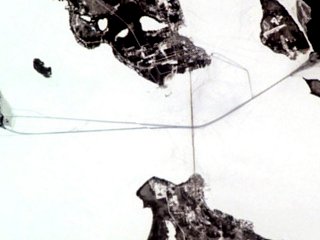
Satellite photograph of icebreaker paths for shipping, including the Round Island
Channel on the upper right-hand corner of the image.
98:, the Round Island Channel became an essential element in one of the most significant commodity supply pipelines of the Great Lakes.
102:
75:
The Round Island
Channel has been in active use since before the arrival of European explorers. With the construction of
248:
141:
110:
124:. This depth is sufficient to provide safe water for lake freighters as massive as 1,000 feet (300 m) long.
56:
79:
in 1780–1781, the channel became a link in the logistics chain operated by the
British Army to supply the fort.
243:
29:
178:
121:
33:
67:
191:
25:
59:, and is used by commercial ferryboats delivering passengers to the small island city.
37:
237:
149:
95:
76:
45:
41:
153:
106:
91:
21:
219:
206:
94:
shortly after 1900 along the shores of southern Lake
Michigan in and around
87:
83:
52:
49:
55:
are shipped annually. The channel also provides access to the harbor of
145:
114:
66:
125:
136:
The Round Island
Channel forms the ending points of the annual
173:"Chart 14881:Inset: Mackinac Island (1/10,000)". NOAA. 2005.
156:, respectively, to the Round Island Channel.
8:
254:Bodies of water of Mackinac County, Michigan
128:and the lights delineate the channel today.
90:in the late 1800s, and the construction of
165:
187:
176:
7:
138:Chicago Yacht Club Race to Mackinac
101:The Round Island Channel is lit by
82:With the discovery of significant
14:
148:race from the southern ends of
48:, on which millions of tons of
144:. In both races, sail-powered
1:
36:. It forms a key link in the
142:Port Huron to Mackinac Race
113:, a 1948 light which has a
270:
111:Round Island Passage Light
140:and its counterpart, the
57:Mackinac Island, Michigan
24:waterway located between
186:Cite journal requires
72:
70:
18:Round Island Channel
249:Straits of Michigan
220:45.8409°N 84.6154°W
216: /
122:St. Lawrence Seaway
34:Straits of Mackinac
103:Round Island Light
86:mines in northern
73:
225:45.8409; -84.6154
261:
231:
230:
228:
227:
226:
221:
217:
214:
213:
212:
209:
196:
195:
189:
184:
182:
174:
170:
269:
268:
264:
263:
262:
260:
259:
258:
244:Mackinac Island
234:
233:
224:
222:
218:
215:
210:
207:
205:
203:
202:
200:
199:
185:
175:
172:
171:
167:
162:
134:
65:
26:Mackinac Island
20:is a navigable
12:
11:
5:
267:
265:
257:
256:
251:
246:
236:
235:
198:
197:
188:|journal=
164:
163:
161:
158:
133:
130:
64:
61:
40:route between
38:lake freighter
13:
10:
9:
6:
4:
3:
2:
266:
255:
252:
250:
247:
245:
242:
241:
239:
232:
229:
193:
180:
169:
166:
159:
157:
155:
151:
150:Lake Michigan
147:
143:
139:
131:
129:
127:
123:
118:
116:
112:
108:
104:
99:
97:
96:Gary, Indiana
93:
89:
85:
80:
78:
77:Fort Mackinac
69:
62:
60:
58:
54:
51:
47:
46:Lake Michigan
43:
42:Lake Superior
39:
35:
31:
27:
23:
19:
201:
179:cite journal
168:
135:
119:
100:
81:
74:
30:Round Island
17:
15:
223: /
92:steel mills
238:Categories
211:84°36′55″W
208:45°50′27″N
160:References
154:Lake Huron
107:lighthouse
105:, an 1895
63:In history
22:Lake Huron
132:In sports
109:, and by
88:Minnesota
84:hematite
53:iron ore
50:taconite
32:in the
146:yachts
126:Buoys
115:Racon
192:help
152:and
44:and
28:and
16:The
240::
183::
181:}}
177:{{
117:.
194:)
190:(
Text is available under the Creative Commons Attribution-ShareAlike License. Additional terms may apply.