1230:
1477:
875:
42:
220:
Precipitation is fairly scarce, mostly coming from thunderstorms during late spring and summer, whilst snowfall averages 43 inches or 1.09 metres (the median is 30.9 inches or 0.78 metres) but significant falls occur on only a minority of winter days. However, during the cold winter of 1977–78, cover
216:
influences that will typically push maximum temperatures over 50 °F or 10 °C on seventeen days during winter and twelve days each in
November and March. Spring is mild and frequently thundery, whilst summer days are hot – sometimes very hot – but nights are usually pleasantly cool.
1541:
1522:
1168:
1020:
1546:
888:
133:
1515:
1117:
1161:
143:
907:
1423:
1551:
1508:
206:
1154:
1146:
1332:
221:
reached 56 inches or 1.42 metres on
February 19 and averaged 46 inches or 1.17 metres for the whole month of February.
1307:
1282:
966:
71:
1337:
1322:
1317:
1302:
833:
179:
860:
49:
939:
928:
1274:
159:
32:
1484:
1447:
1178:
163:
76:
1372:
1292:
1454:
1254:
1347:
1415:
1367:
1219:
1200:
183:
1013:
1377:
1264:
202:
1492:
1405:
1362:
1357:
1297:
950:
1387:
1312:
1287:
1249:
193:
The post office opened in 1892. The
Milwaukee Land Company platted the townsite in 1913.
1382:
1259:
880:
1535:
558:
213:
1109:
1193:
1041:
228:
Climate data for Roy 8 NE, Montana (1971–2000; extremes 1948−2001)
1476:
1397:
1014:"Climatography of the United States No. 20: 1971-2000 – Station: ROY 8 NE, MT"
870:
59:
1132:
1119:
859:
Roy Public
Schools educates students from kindergarten through 12th grade.
1438:‡This populated place also has portions in an adjacent county or counties
929:
U.S. Geological Survey
Geographic Names Information System: Roy, Montana
1488:
167:
64:
41:
1085:
187:
182:
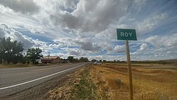
in northeastern Fergus County, 35 miles (56 km) northeast of
1241:
1211:
1150:
940:
U.S. Geological Survey
Geographic Names Information System: Roy
1228:
987:
186:. Roy has a post office with the ZIP code 59471. As of the
1063:
962:
1496:
1433:
1414:
1396:
1346:
1273:
1240:
1210:
142:
132:
124:
116:
111:
103:
95:
87:
82:
70:
58:
48:
23:
1542:Census-designated places in Fergus County, Montana
18:Census-Designated Place in Montana, United States
1021:National Oceanic and Atmospheric Administration
1516:
1162:
212:) with cold winters except when moderated by
8:
889:List of census-designated places in Montana
1523:
1509:
1169:
1155:
1147:
806:
224:
20:
1229:
899:
131:
110:
81:
47:
38:
826:
141:
123:
115:
102:
94:
86:
69:
57:
7:
1473:
1471:
1547:Census-designated places in Montana
107:0.00 sq mi (0.00 km)
99:3.40 sq mi (8.82 km)
91:3.40 sq mi (8.82 km)
1495:. You can help Knowledge (XXG) by
1424:Turtle Mountain Indian Reservation
1177:Municipalities and communities of
1042:"Census of Population and Housing"
816:
14:
1088:. Montana High School Association
1475:
908:"ArcGIS REST Services Directory"
873:
190:of 2010, there were 108 people.
40:
178:The community is located along
1:
1110:Roy – Russell Country Montana
992:Montana Place Names Companion
910:. United States Census Bureau
863:'s team name is the Pirates.
631:Average snowfall inches (cm)
1491:state location article is a
994:. Montana Historical Society
967:United States Census Bureau
701:Average precipitation days
417:Mean daily minimum °F (°C)
347:Mean daily maximum °F (°C)
128:28.20/sq mi (10.89/km)
1568:
1470:
794:
227:
1443:
1226:
1191:
951:USPS – Cities by ZIP Code
847:
832:
825:
820:
815:
812:
747:
700:
630:
556:
486:
416:
346:
276:
271:
268:
265:
262:
259:
256:
253:
250:
247:
244:
241:
238:
235:
232:
39:
30:
1552:Montana geography stubs
160:census-designated place
33:Census-Designated Place
1234:
1180:Fergus County, Montana
1133:47.33139°N 108.96000°W
1232:
963:"U.S. Census website"
848:U.S. Decennial Census
808:Historical population
1456:United States portal
1138:47.33139; -108.96000
277:Record high °F (°C)
125: • Density
1333:Spring Creek Colony
1129: /
809:
748:Average snowy days
487:Record low °F (°C)
1416:Indian reservation
1308:Fords Creek Colony
1283:Ayers Ranch Colony
1235:
807:
117: • Total
104: • Water
88: • Total
1504:
1503:
1465:
1464:
1338:Warm Spring Creek
1323:Lewistown Heights
1318:King Ranch Colony
1233:Fergus County map
852:
851:
799:
798:
203:semi-arid climate
170:, United States.
153:
152:
96: • Land
1559:
1525:
1518:
1511:
1479:
1472:
1457:
1450:
1303:Deerfield Colony
1231:
1203:
1196:
1186:
1181:
1171:
1164:
1157:
1148:
1144:
1143:
1141:
1140:
1139:
1134:
1130:
1127:
1126:
1125:
1122:
1098:
1097:
1095:
1093:
1086:"Member Schools"
1082:
1076:
1075:
1073:
1071:
1060:
1054:
1053:
1051:
1049:
1038:
1032:
1031:
1029:
1027:
1018:
1010:
1004:
1003:
1001:
999:
984:
978:
977:
975:
973:
959:
953:
948:
942:
937:
931:
926:
920:
919:
917:
915:
904:
883:
878:
877:
876:
828:
823:
818:
810:
751:
704:
225:
44:
21:
1567:
1566:
1562:
1561:
1560:
1558:
1557:
1556:
1532:
1531:
1530:
1529:
1468:
1466:
1461:
1455:
1448:
1439:
1429:
1410:
1392:
1349:
1342:
1269:
1236:
1224:
1206:
1201:
1194:
1187:
1184:
1179:
1175:
1137:
1135:
1131:
1128:
1123:
1120:
1118:
1116:
1115:
1106:
1101:
1091:
1089:
1084:
1083:
1079:
1069:
1067:
1062:
1061:
1057:
1047:
1045:
1040:
1039:
1035:
1025:
1023:
1016:
1012:
1011:
1007:
997:
995:
986:
985:
981:
971:
969:
961:
960:
956:
949:
945:
938:
934:
927:
923:
913:
911:
906:
905:
901:
897:
879:
874:
872:
869:
861:Roy High School
857:
821:
805:
800:
749:
702:
695:
690:
685:
680:
675:
670:
665:
660:
655:
650:
645:
640:
635:
625:
620:
615:
610:
605:
600:
595:
590:
585:
580:
575:
570:
565:
551:
546:
541:
536:
531:
526:
521:
516:
511:
506:
501:
496:
491:
481:
476:
471:
466:
461:
456:
451:
446:
441:
436:
431:
426:
421:
411:
406:
401:
396:
391:
386:
381:
376:
371:
366:
361:
356:
351:
341:
336:
331:
326:
321:
316:
311:
306:
301:
296:
291:
286:
281:
199:
176:
35:
26:
19:
12:
11:
5:
1565:
1563:
1555:
1554:
1549:
1544:
1534:
1533:
1528:
1527:
1520:
1513:
1505:
1502:
1501:
1480:
1463:
1462:
1460:
1459:
1452:
1449:Montana portal
1444:
1441:
1440:
1437:
1435:
1431:
1430:
1428:
1427:
1420:
1418:
1412:
1411:
1409:
1408:
1402:
1400:
1394:
1393:
1391:
1390:
1385:
1380:
1375:
1370:
1365:
1360:
1354:
1352:
1344:
1343:
1341:
1340:
1335:
1330:
1325:
1320:
1315:
1310:
1305:
1300:
1295:
1290:
1285:
1279:
1277:
1271:
1270:
1268:
1267:
1262:
1257:
1252:
1246:
1244:
1238:
1237:
1227:
1225:
1223:
1222:
1216:
1214:
1208:
1207:
1192:
1189:
1188:
1176:
1174:
1173:
1166:
1159:
1151:
1113:
1112:
1105:
1104:External links
1102:
1100:
1099:
1077:
1055:
1033:
1005:
979:
954:
943:
932:
921:
898:
896:
893:
892:
891:
885:
884:
881:Montana portal
868:
865:
856:
853:
850:
849:
845:
844:
841:
839:
836:
830:
829:
824:
819:
814:
804:
801:
797:
796:
792:
791:
788:
785:
782:
779:
776:
773:
770:
767:
764:
761:
758:
755:
752:
745:
744:
741:
738:
735:
732:
729:
726:
723:
720:
717:
714:
711:
708:
705:
698:
697:
692:
687:
682:
677:
672:
667:
662:
657:
652:
647:
642:
637:
632:
628:
627:
622:
617:
612:
607:
602:
597:
592:
587:
582:
577:
572:
567:
562:
554:
553:
548:
543:
538:
533:
528:
523:
518:
513:
508:
503:
498:
493:
488:
484:
483:
478:
473:
468:
463:
458:
453:
448:
443:
438:
433:
428:
423:
418:
414:
413:
408:
403:
398:
393:
388:
383:
378:
373:
368:
363:
358:
353:
348:
344:
343:
338:
333:
328:
323:
318:
313:
308:
303:
298:
293:
288:
283:
278:
274:
273:
270:
267:
264:
261:
258:
255:
252:
249:
246:
243:
240:
237:
234:
230:
229:
223:
198:
195:
180:U.S. Route 191
175:
172:
151:
150:
147:
140:
139:
136:
130:
129:
126:
122:
121:
118:
114:
113:
109:
108:
105:
101:
100:
97:
93:
92:
89:
85:
84:
80:
79:
74:
68:
67:
62:
56:
55:
52:
46:
45:
37:
36:
31:
28:
27:
24:
17:
13:
10:
9:
6:
4:
3:
2:
1564:
1553:
1550:
1548:
1545:
1543:
1540:
1539:
1537:
1526:
1521:
1519:
1514:
1512:
1507:
1506:
1500:
1498:
1494:
1490:
1486:
1485:Fergus County
1481:
1478:
1474:
1469:
1458:
1453:
1451:
1446:
1445:
1442:
1436:
1432:
1425:
1422:
1421:
1419:
1417:
1413:
1407:
1404:
1403:
1401:
1399:
1395:
1389:
1386:
1384:
1381:
1379:
1376:
1374:
1371:
1369:
1366:
1364:
1361:
1359:
1356:
1355:
1353:
1351:
1345:
1339:
1336:
1334:
1331:
1329:
1326:
1324:
1321:
1319:
1316:
1314:
1311:
1309:
1306:
1304:
1301:
1299:
1296:
1294:
1291:
1289:
1286:
1284:
1281:
1280:
1278:
1276:
1272:
1266:
1263:
1261:
1258:
1256:
1253:
1251:
1248:
1247:
1245:
1243:
1239:
1221:
1218:
1217:
1215:
1213:
1209:
1205:
1204:
1197:
1190:
1185:United States
1182:
1172:
1167:
1165:
1160:
1158:
1153:
1152:
1149:
1145:
1142:
1111:
1108:
1107:
1103:
1087:
1081:
1078:
1066:. Roy Schools
1065:
1064:"Roy Schools"
1059:
1056:
1043:
1037:
1034:
1026:September 14,
1022:
1015:
1009:
1006:
993:
989:
983:
980:
968:
964:
958:
955:
952:
947:
944:
941:
936:
933:
930:
925:
922:
914:September 18,
909:
903:
900:
894:
890:
887:
886:
882:
871:
866:
864:
862:
854:
846:
842:
840:
837:
835:
831:
811:
802:
795:Source: NOAA
793:
789:
786:
783:
780:
777:
774:
771:
768:
765:
762:
759:
756:
753:
746:
742:
739:
736:
733:
730:
727:
724:
721:
718:
715:
712:
709:
706:
699:
693:
688:
683:
678:
673:
668:
663:
658:
653:
648:
643:
638:
633:
629:
623:
618:
613:
608:
603:
598:
593:
588:
583:
578:
573:
568:
563:
560:
559:precipitation
555:
549:
544:
539:
534:
529:
524:
519:
514:
509:
504:
499:
494:
489:
485:
479:
474:
469:
464:
459:
454:
449:
444:
439:
434:
429:
424:
419:
415:
409:
404:
399:
394:
389:
384:
379:
374:
369:
364:
359:
354:
349:
345:
339:
334:
329:
324:
319:
314:
309:
304:
299:
294:
289:
284:
279:
275:
231:
226:
222:
218:
215:
211:
208:
204:
196:
194:
191:
189:
185:
181:
173:
171:
169:
165:
164:Fergus County
161:
157:
148:
145:
137:
135:
127:
119:
106:
98:
90:
78:
75:
73:
66:
63:
61:
54:United States
53:
51:
43:
34:
29:
22:
16:
1497:expanding it
1482:
1467:
1373:Forest Grove
1327:
1293:Coffee Creek
1199:
1114:
1090:. Retrieved
1080:
1068:. Retrieved
1058:
1046:. Retrieved
1044:. Census.gov
1036:
1024:. Retrieved
1008:
996:. Retrieved
991:
982:
970:. Retrieved
957:
946:
935:
924:
912:. Retrieved
902:
858:
803:Demographics
561:inches (mm)
219:
209:
200:
192:
177:
155:
154:
25:Roy, Montana
15:
1350:communities
1255:Grass Range
1195:County seat
1136: /
1124:108°57′36″W
703:(≥ 0.01 in)
174:Description
1536:Categories
1398:Ghost town
1121:47°19′53″N
895:References
750:(≥ 0.1 in)
201:Roy has a
146:feature ID
112:Population
1434:Footnotes
1368:Christina
1220:Lewistown
1202:Lewistown
1092:April 19,
1070:April 20,
855:Education
696:(110.61)
184:Lewistown
162:(CDP) in
134:FIPS code
1378:Garneill
1265:Winifred
998:April 9,
972:July 10,
867:See also
626:(360.9)
557:Average
477:(−12.0)
427:(−10.5)
422:(−13.5)
138:30-64675
1489:Montana
1406:Armells
1363:Buffalo
1358:Amherst
1298:Danvers
1048:June 4,
676:(0.51)
482:(−0.6)
472:(−6.9)
457:(11.1)
452:(11.7)
437:(−0.6)
432:(−5.6)
412:(14.6)
397:(16.2)
392:(22.7)
387:(29.2)
382:(29.2)
377:(24.9)
372:(19.7)
367:(14.2)
352:(−0.2)
214:chinook
197:Climate
168:Montana
65:Montana
50:Country
1388:Hoosac
1313:Hilger
1288:Brooks
1250:Denton
813:Census
681:(5.8)
671:(0.0)
666:(0.0)
661:(0.0)
656:(2.3)
571:(7.9)
552:(−41)
547:(−41)
542:(−34)
537:(−24)
512:(−12)
507:(−21)
502:(−36)
497:(−39)
492:(−41)
467:(0.1)
462:(5.6)
447:(9.1)
442:(4.6)
407:(1.3)
402:(6.5)
362:(8.1)
357:(3.2)
233:Month
207:Köppen
188:census
149:775990
77:Fergus
72:County
1483:This
1383:Heath
1348:Other
1260:Moore
1242:Towns
1017:(PDF)
988:"Roy"
743:74.1
691:(21)
686:(14)
651:(11)
646:(21)
641:(14)
636:(21)
624:14.18
621:(13)
616:(11)
611:(19)
606:(31)
601:(39)
596:(50)
591:(58)
586:(69)
581:(29)
576:(21)
566:(13)
532:(−9)
527:(−1)
517:(−2)
342:(42)
337:(21)
332:(26)
327:(33)
322:(39)
317:(42)
312:(41)
307:(39)
302:(36)
297:(32)
292:(26)
287:(22)
282:(21)
272:Year
158:is a
60:State
1493:stub
1275:CDPs
1212:City
1094:2021
1072:2021
1050:2016
1028:2016
1000:2021
974:2015
916:2022
834:2020
822:Note
817:Pop.
787:3.7
784:2.7
781:0.7
778:0.1
775:0.0
772:0.0
769:0.0
766:0.4
763:1.4
760:3.5
757:2.6
754:3.9
740:4.7
737:4.4
734:4.4
731:6.1
728:6.8
725:7.3
722:9.9
719:9.9
716:6.2
713:6.1
710:3.6
707:4.7
619:0.50
614:0.44
609:0.73
604:1.22
599:1.53
594:1.97
589:2.30
584:2.73
579:1.14
574:0.81
569:0.31
564:0.50
522:(2)
480:31.0
475:10.4
470:19.6
465:32.1
460:42.0
455:52.0
450:53.0
445:48.4
440:40.3
435:31.0
430:21.9
425:13.1
410:58.3
405:34.3
400:43.7
395:61.1
390:72.9
385:84.6
380:84.6
375:76.9
370:67.5
365:57.6
360:46.5
355:37.8
350:31.7
269:Dec
266:Nov
263:Oct
260:Sep
257:Aug
254:Jul
251:Jun
248:May
245:Apr
242:Mar
239:Feb
236:Jan
144:GNIS
83:Area
1328:Roy
790:19
689:8.1
684:5.6
679:2.3
674:0.2
669:0.0
664:0.0
659:0.0
654:0.9
649:4.3
644:8.1
639:5.4
634:8.1
550:−41
545:−41
540:−29
535:−11
500:−33
495:−39
490:−41
420:7.7
340:107
320:103
315:107
310:105
305:103
210:BSk
156:Roy
1538::
1487:,
1198::
1183:,
1019:.
990:.
965:.
838:96
827:%±
694:43
530:16
525:30
520:36
515:29
510:10
505:−5
335:69
330:78
325:92
300:96
295:90
290:78
285:72
280:69
166:,
120:96
1524:e
1517:t
1510:v
1499:.
1426:‡
1170:e
1163:t
1156:v
1096:.
1074:.
1052:.
1030:.
1002:.
976:.
918:.
843:—
205:(
Text is available under the Creative Commons Attribution-ShareAlike License. Additional terms may apply.