47:
54:
759:
31:
369:
Standburn was a mining community with several active pits until the 1950s. The pits were individually numbered and all prefixed by
Gateside. The bings from the mining days can still be seen although the land has now been planted with trees and named Gateside Woodland.
401:
46:
234:
224:
216:
448:
398:
242:
97:
819:
800:
824:
441:
206:
379:
434:
285:
270:
194:
160:
793:
142:
90:
357:
353:
275:
83:
786:
174:
124:
766:
458:
322:
132:
67:
553:
150:
738:
713:
688:
663:
638:
568:
346:
114:
653:
618:
528:
770:
683:
673:
633:
598:
199:
678:
643:
578:
405:
487:
813:
588:
507:
482:
758:
728:
628:
608:
106:
733:
718:
703:
583:
497:
477:
613:
548:
533:
472:
342:
334:
356:
reported the population as 149 residents, a figure almost unchanged from the
300:
287:
698:
693:
658:
603:
563:
538:
330:
184:
362:
Drumbowie
Environment Action Group is a charitable organisation which owns
366:
to the north of
Standburn, this community woodland is open to the public.
648:
593:
558:
543:
426:
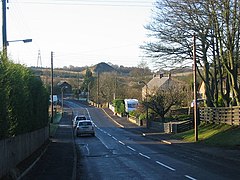
341:. The entire village is located along a section of the B825 road between
326:
166:
723:
668:
573:
502:
492:
338:
30:
623:
523:
430:
255:
421:
774:
399:
No 3 - 2001 Census
Population of settlements and wards
329:. It is located 1.3 miles (2.1 km) south-west of
516:
465:
251:
233:
215:
205:
193:
183:
173:
159:
141:
123:
105:
89:
78:
23:
794:
442:
8:
801:
787:
449:
435:
427:
337:and 4.0 miles (6.4 km) south east of
20:
321:is a small village which lies within the
408:www.falkirk.gov.uk. Retrieved 2011-05-02
333:, 1.7 miles (2.7 km) north-east of
391:
250:
214:
182:
158:
88:
27:
380:List of places in Falkirk council area
232:
204:
192:
172:
140:
122:
7:
755:
753:
820:Villages in Falkirk (council area)
773:. You can help Knowledge (XXG) by
422:Drumbowie Environment Action Group
14:
53:
825:Central Scotland geography stubs
757:
52:
45:
29:
1:
18:Human settlement in Scotland
225:Linlithgow and East Falkirk
91:OS grid reference
841:
752:
354:United Kingdom Census 2001
261:
40:
28:
235:Scottish Parliament
35:The village of Standburn
609:Glen Village / Hallglen
769:location article is a
195:Postcode district
143:Lieutenancy area
323:Falkirk council area
175:Sovereign state
151:Stirling and Falkirk
66:Location within the
297: /
404:2011-06-03 at the
301:55.9523°N 3.7215°W
217:UK Parliament
207:Dialling code
782:
781:
747:
746:
316:
315:
125:Council area
832:
803:
796:
789:
761:
754:
634:High Bonnybridge
451:
444:
437:
428:
409:
396:
312:
311:
309:
308:
307:
306:55.9523; -3.7215
302:
298:
295:
294:
293:
290:
267:
169:
101:
100:
56:
55:
49:
33:
21:
840:
839:
835:
834:
833:
831:
830:
829:
810:
809:
808:
807:
750:
748:
743:
679:Reddingmuirhead
512:
461:
457:Settlements in
455:
418:
413:
412:
406:Wayback Machine
397:
393:
388:
376:
305:
303:
299:
296:
291:
288:
286:
284:
283:
282:
265:
247:
229:
165:
155:
137:
119:
96:
95:
74:
73:
72:
71:
64:
63:
62:
61:
57:
36:
19:
12:
11:
5:
838:
836:
828:
827:
822:
812:
811:
806:
805:
798:
791:
783:
780:
779:
762:
745:
744:
742:
741:
736:
731:
726:
721:
716:
711:
706:
701:
696:
691:
686:
681:
676:
671:
666:
661:
656:
651:
646:
641:
636:
631:
626:
621:
616:
611:
606:
601:
596:
591:
586:
581:
576:
571:
566:
561:
556:
551:
546:
541:
536:
531:
526:
520:
518:
514:
513:
511:
510:
505:
500:
495:
490:
485:
483:Braes villages
480:
475:
469:
467:
463:
462:
456:
454:
453:
446:
439:
431:
425:
424:
417:
416:External links
414:
411:
410:
390:
389:
387:
384:
383:
382:
375:
372:
364:Drumbowie Park
358:census of 1991
314:
313:
281:
280:
278:
273:
268:
266:List of places
262:
259:
258:
256:falkirk.gov.uk
253:
249:
248:
246:
245:
239:
237:
231:
230:
228:
227:
221:
219:
213:
212:
209:
203:
202:
197:
191:
190:
187:
181:
180:
179:United Kingdom
177:
171:
170:
163:
157:
156:
154:
153:
147:
145:
139:
138:
136:
135:
129:
127:
121:
120:
118:
117:
111:
109:
103:
102:
93:
87:
86:
80:
76:
75:
65:
59:
58:
51:
50:
44:
43:
42:
41:
38:
37:
34:
26:
25:
17:
13:
10:
9:
6:
4:
3:
2:
837:
826:
823:
821:
818:
817:
815:
804:
799:
797:
792:
790:
785:
784:
778:
776:
772:
768:
763:
760:
756:
751:
740:
737:
735:
732:
730:
727:
725:
722:
720:
717:
715:
712:
710:
707:
705:
702:
700:
697:
695:
692:
690:
687:
685:
682:
680:
677:
675:
672:
670:
667:
665:
662:
660:
657:
655:
652:
650:
647:
645:
642:
640:
637:
635:
632:
630:
627:
625:
622:
620:
617:
615:
612:
610:
607:
605:
602:
600:
597:
595:
592:
590:
589:Dennyloanhead
587:
585:
582:
580:
577:
575:
572:
570:
567:
565:
562:
560:
557:
555:
552:
550:
547:
545:
542:
540:
537:
535:
532:
530:
527:
525:
522:
521:
519:
515:
509:
508:Stenhousemuir
506:
504:
501:
499:
496:
494:
491:
489:
486:
484:
481:
479:
476:
474:
471:
470:
468:
464:
460:
452:
447:
445:
440:
438:
433:
432:
429:
423:
420:
419:
415:
407:
403:
400:
395:
392:
385:
381:
378:
377:
373:
371:
367:
365:
360:
359:
355:
350:
348:
344:
340:
336:
332:
328:
324:
320:
310:
279:
277:
274:
272:
269:
264:
263:
260:
257:
254:
244:
241:
240:
238:
236:
226:
223:
222:
220:
218:
210:
208:
201:
198:
196:
188:
186:
178:
176:
168:
164:
162:
152:
149:
148:
146:
144:
134:
131:
130:
128:
126:
116:
113:
112:
110:
108:
104:
99:
94:
92:
85:
84:(2001 census)
81:
77:
69:
48:
39:
32:
22:
16:
775:expanding it
764:
749:
729:Wallacestone
708:
629:Head of Muir
394:
368:
363:
361:
351:
318:
317:
243:Falkirk East
115:Muiravonside
107:Civil parish
70:council area
15:
734:Westquarter
719:Tamfourhill
704:South Alloa
584:Carronshore
498:Grangemouth
478:Bonnybridge
325:in central
304: /
814:Categories
739:Whitecross
714:Stoneywood
689:Shieldhill
664:Muirhouses
639:Laurieston
614:Glensburgh
569:California
549:Binniehill
534:Avonbridge
386:References
343:Avonbridge
335:Avonbridge
289:55°57′08″N
82:149
79:Population
709:Standburn
699:Slamannan
694:Skinflats
659:Maddiston
654:Longcroft
619:Greenhill
604:Fankerton
564:Brightons
554:Blackness
539:Bainsford
529:Allandale
331:Maddiston
319:Standburn
292:3°43′17″W
185:Post town
60:Standburn
24:Standburn
649:Limerigg
594:Dunipace
559:Braeface
544:Banknock
517:Villages
402:Archived
374:See also
327:Scotland
276:Scotland
167:Scotland
98:NS925745
767:Falkirk
724:Torwood
684:Rumford
674:Redding
669:Polmont
599:Dunmore
574:Camelon
503:Larbert
493:Falkirk
473:Bo'ness
459:Falkirk
339:Falkirk
252:Website
189:FALKIRK
161:Country
133:Falkirk
68:Falkirk
644:Letham
579:Carron
765:This
624:Haggs
524:Airth
488:Denny
466:Towns
211:01324
771:stub
352:The
347:Loan
345:and
200:FK1
816::
349:.
271:UK
802:e
795:t
788:v
777:.
450:e
443:t
436:v
Text is available under the Creative Commons Attribution-ShareAlike License. Additional terms may apply.