31:
243:
115:
288:
317:
129:
312:
30:
204:
102:
281:
124:
59:
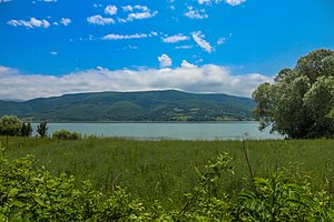
89:, the lake abounded in fish, and its shores afforded excellent pasture. The southern shore of Ladik Lake was the
307:
274:
94:
174:
50:
258:
42:
250:
70:
161:
78:
301:
119:
82:
154:
77:. Anciently it was called Stiphane, and was located in the northwestern part of
242:
219:
206:
90:
179:
Boğaziçi
University, Kandilli Observatory and Earthquake Research Institute
74:
118: This article incorporates text from a publication now in the
17:
254:
149:
86:
105:, which is the most powerful earthquake recorded in Turkey.
64:
262:
249:This geographical article about a location in
282:
175:"Tarihsel Depremler (Historical Earthquakes)"
8:
289:
275:
95:
144:
142:
29:
138:
130:Dictionary of Greek and Roman Geography
7:
239:
237:
261:. You can help Knowledge (XXG) by
25:
241:
113:
318:Samsun Province geography stubs
160:Page numbers refer to those of
127:, ed. (1854–1857). "Stiphane".
103:1668 North Anatolia earthquake
1:
27:Lake in Ladik, Samsun, Turkey
313:Geography of Samsun Province
65:
334:
236:
54:
81:, in the district called
158:. Vol. xii. p. 560.
220:40.905278°N 36.015278°E
133:. London: John Murray.
46:
35:
33:
225:40.905278; 36.015278
216: /
36:
270:
269:
63:
16:(Redirected from
325:
291:
284:
277:
245:
238:
231:
230:
228:
227:
226:
221:
217:
214:
213:
212:
209:
191:
190:
188:
186:
171:
165:
159:
146:
134:
117:
116:
100:
68:
58:
56:
21:
333:
332:
328:
327:
326:
324:
323:
322:
308:Lakes of Turkey
298:
297:
296:
295:
251:Samsun Province
234:
224:
222:
218:
215:
210:
207:
205:
203:
202:
200:
195:
194:
184:
182:
173:
172:
168:
148:
147:
140:
123:
114:
111:
99:
93:of the 7.8–8.0
85:. According to
71:Samsun Province
69:) is a lake in
28:
23:
22:
15:
12:
11:
5:
331:
329:
321:
320:
315:
310:
300:
299:
294:
293:
286:
279:
271:
268:
267:
246:
199:
198:External links
196:
193:
192:
166:
162:Isaac Casaubon
137:
136:
125:Smith, William
110:
107:
97:
79:ancient Pontus
75:Asiatic Turkey
66:Stiphane Limne
26:
24:
14:
13:
10:
9:
6:
4:
3:
2:
330:
319:
316:
314:
311:
309:
306:
305:
303:
292:
287:
285:
280:
278:
273:
272:
266:
264:
260:
256:
252:
247:
244:
240:
235:
232:
229:
197:
180:
176:
170:
167:
163:
157:
156:
151:
145:
143:
139:
135:
132:
131:
126:
121:
120:public domain
108:
106:
104:
101:
92:
88:
84:
80:
76:
72:
67:
61:
55:Στιφάνη Λίμνη
52:
51:Ancient Greek
48:
44:
40:
32:
19:
263:expanding it
248:
233:
201:
183:. Retrieved
181:(in Turkish)
178:
169:
164:'s edition.
153:
128:
112:
83:Phazemonitis
38:
37:
223: /
155:Geographica
302:Categories
211:36°00′55″E
208:40°54′19″N
185:1 February
109:References
47:Ladik Gölü
39:Ladik Lake
34:Ladik Lake
91:epicenter
60:romanized
18:Stiphane
122::
62::
43:Turkish
255:Turkey
150:Strabo
87:Strabo
257:is a
259:stub
187:2020
304::
253:,
177:.
152:.
141:^
73:,
57:,
53::
49:;
45::
290:e
283:t
276:v
265:.
189:.
98:s
96:M
41:(
20:)
Text is available under the Creative Commons Attribution-ShareAlike License. Additional terms may apply.