209:
243:, which was under construction at the time of the hurricane, located 0.8 miles (1.3 km) to the north. The span was closed to marine traffic after the hurricane. After inspection, it was decided to close the bridge to bus and truck traffic on January 13, 1955. It was then closed to all vehicles on January 18, 1955. Pedestrians were allowed to walk across. Repairs were made and the bridge reopened to all traffic on March 3, 1955. It remained in service until the opening of the Sakonnet River Bridge in 1956.
560:
739:
33:
84:
382:
216:
A ferry between
Portsmouth and Tiverton – probably the first regular ferry in Rhode Island – began operating in 1640. It was variously known as Howland's Ferry (after the family that ran it from around 1703 to 1776), Pocasset Ferry, Sanford's Ferry and Wanton's Ferry. A privately-owned wooden toll
217:
bridge was built in 1795. After it was destroyed several times by storms, a stone causeway with a wooden draw span was built in 1810. The towns of
Tiverton and Portsmouth purchased the bridge in 1871 and conveyed it to the state.
840:
776:
835:
845:
815:
825:
810:
805:
830:
795:
769:
426:
762:
820:
386:
800:
282:
47:
419:
696:
660:
635:
630:
529:
499:
40:
706:
494:
474:
650:
539:
534:
509:
489:
479:
504:
484:
412:
364:
345:
326:
304:
225:
208:
670:
665:
645:
615:
185:
107:
640:
221:
625:
454:
189:
177:
111:
87:
716:
680:
655:
620:
240:
197:
675:
514:
399:
559:
711:
544:
746:
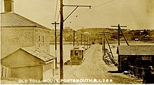
228:. The heavy streetcars necessitated replacement of the wooden draw span. A double-leaf steel
192:. The span was built in 1907, replacing an earlier wooden bridge. It was severely damaged by
701:
584:
574:
464:
459:
449:
435:
524:
519:
236:
193:
589:
579:
469:
229:
181:
173:
97:
789:
599:
594:
738:
393:
115:
266:
32:
549:
62:
49:
288:. The Roger Williams University Community Partnerships Center. Summer 2014.
381:
404:
207:
130:
246:
The remaining approaches serve as breakwaters and fishing piers.
408:
299:"Bus and Truck Traffic Is Barred From Stone Bridge, Tiverton".
265:
Federal
Writers' Project (US History Publishers, 1977) pg. 416
750:
340:"Tiverton Request Would Cut Walking Distance on Span".
321:"Stone Bridge To Close Tuesday; Repairs Are Ordered".
841:
Northeastern United States bridge (structure) stubs
689:
608:
567:
442:
157:
149:
141:
136:
126:
121:
103:
93:
78:
39:
23:
745:This article about a bridge in Rhode Island is a
348:: Edward J. Delaney. January 20, 1955. p. 1.
329:: Edward J. Delaney. January 14, 1955. p. 1.
307:: Edward J. Delaney. January 13, 1955. p. 1.
367:: Edward J. Delaney. March 4, 1955. p. 1.
770:
420:
212:A streetcar crossing the bridge prior to 1907
8:
277:
275:
273:
263:Rhode Island: A Guide to the Smallest State,
836:Buildings and structures demolished in 1957
400:Report of the Stone Bridge Commission, 1904
777:
763:
427:
413:
405:
20:
846:Rhode Island building and structure stubs
316:
314:
816:Former road bridges in the United States
826:Stone arch bridges in the United States
811:Demolished bridges in the United States
806:Bridges in Newport County, Rhode Island
255:
831:1957 disestablishments in Rhode Island
239:in 1954, and replaced in 1956 by the
196:in 1954, and replaced in 1956 by the
7:
735:
733:
796:1907 establishments in Rhode Island
235:The bridge was severely damaged by
224:opened in 1898 between Newport and
749:. You can help Knowledge (XXG) by
16:Former bridge in the United States
14:
737:
558:
380:
359:"Trucks Crossing Stone Bridge".
82:
31:
394:Tiverton Stone Bridge Committee
1:
697:Claiborne Pell Newport Bridge
821:Road bridges in Rhode Island
707:Jamestown Verrazzano Bridge
387:Stone Bridge (Rhode Island)
862:
732:
801:Bridges completed in 1907
556:
396:with historic photographs
365:Fall River, Massachusetts
346:Fall River, Massachusetts
327:Fall River, Massachusetts
305:Fall River, Massachusetts
283:"Stone Bridge Reimagined"
226:Fall River, Massachusetts
162:
30:
455:Coasters Harbor Island
361:Fall River Herald News
342:Fall River Herald News
323:Fall River Herald News
301:Fall River Herald News
222:Newport Street Railway
213:
178:Rhode Island Route 138
717:Sakonnet River Bridge
389:at Wikimedia Commons
241:Sakonnet River Bridge
211:
198:Sakonnet River Bridge
63:41.62573°N 71.21716°W
230:rolling lift bridge
68:41.62573; -71.21716
59: /
609:Cities & towns
214:
758:
757:
730:
729:
712:Mount Hope Bridge
545:Starvegoat Island
385:Media related to
166:
165:
853:
779:
772:
765:
741:
734:
702:Jamestown Bridge
585:Providence River
575:Blackstone River
562:
465:Cornelius Island
460:Conanicut Island
450:Aquidneck Island
436:Narragansett Bay
429:
422:
415:
406:
384:
369:
368:
356:
350:
349:
337:
331:
330:
318:
309:
308:
296:
290:
289:
287:
279:
268:
260:
232:opened in 1907.
145:1795, 1810, 1907
86:
85:
74:
73:
71:
70:
69:
64:
60:
57:
56:
55:
52:
35:
21:
861:
860:
856:
855:
854:
852:
851:
850:
786:
785:
784:
783:
731:
726:
685:
661:North Kingstown
636:East Providence
604:
563:
554:
525:Prudence Island
520:Patience Island
438:
433:
378:
373:
372:
358:
357:
353:
339:
338:
334:
320:
319:
312:
298:
297:
293:
285:
281:
280:
271:
261:
257:
252:
237:Hurricane Carol
206:
194:Hurricane Carol
122:Characteristics
83:
67:
65:
61:
58:
53:
50:
48:
46:
45:
26:
17:
12:
11:
5:
859:
857:
849:
848:
843:
838:
833:
828:
823:
818:
813:
808:
803:
798:
788:
787:
782:
781:
774:
767:
759:
756:
755:
742:
728:
727:
725:
724:
719:
714:
709:
704:
699:
693:
691:
687:
686:
684:
683:
678:
673:
668:
663:
658:
653:
648:
643:
638:
633:
631:East Greenwich
628:
623:
618:
612:
610:
606:
605:
603:
602:
597:
592:
590:Sakonnet River
587:
582:
580:Pawtuxet River
577:
571:
569:
565:
564:
557:
555:
553:
552:
547:
542:
537:
532:
527:
522:
517:
512:
507:
502:
497:
492:
487:
482:
477:
472:
470:Despair Island
467:
462:
457:
452:
446:
444:
440:
439:
434:
432:
431:
424:
417:
409:
403:
402:
397:
377:
376:External links
374:
371:
370:
351:
332:
310:
291:
269:
254:
253:
251:
248:
205:
202:
182:Sakonnet River
174:bascule bridge
164:
163:
160:
159:
155:
154:
151:
147:
146:
143:
139:
138:
134:
133:
128:
124:
123:
119:
118:
105:
101:
100:
98:Sakonnet River
95:
91:
90:
88:Route 138
80:
76:
75:
43:
37:
36:
28:
27:
24:
15:
13:
10:
9:
6:
4:
3:
2:
858:
847:
844:
842:
839:
837:
834:
832:
829:
827:
824:
822:
819:
817:
814:
812:
809:
807:
804:
802:
799:
797:
794:
793:
791:
780:
775:
773:
768:
766:
761:
760:
754:
752:
748:
743:
740:
736:
723:
720:
718:
715:
713:
710:
708:
705:
703:
700:
698:
695:
694:
692:
688:
682:
679:
677:
674:
672:
669:
667:
664:
662:
659:
657:
654:
652:
649:
647:
644:
642:
639:
637:
634:
632:
629:
627:
624:
622:
619:
617:
614:
613:
611:
607:
601:
600:Taunton River
598:
596:
595:Seekonk River
593:
591:
588:
586:
583:
581:
578:
576:
573:
572:
570:
566:
561:
551:
548:
546:
543:
541:
538:
536:
533:
531:
530:Rabbit Island
528:
526:
523:
521:
518:
516:
513:
511:
508:
506:
503:
501:
500:Greene Island
498:
496:
493:
491:
488:
486:
483:
481:
478:
476:
473:
471:
468:
466:
463:
461:
458:
456:
453:
451:
448:
447:
445:
441:
437:
430:
425:
423:
418:
416:
411:
410:
407:
401:
398:
395:
392:
391:
390:
388:
383:
375:
366:
362:
355:
352:
347:
343:
336:
333:
328:
324:
317:
315:
311:
306:
302:
295:
292:
284:
278:
276:
274:
270:
267:
264:
259:
256:
249:
247:
244:
242:
238:
233:
231:
227:
223:
218:
210:
203:
201:
199:
195:
191:
187:
183:
179:
176:that carried
175:
171:
161:
156:
152:
148:
144:
140:
135:
132:
129:
125:
120:
117:
113:
109:
106:
102:
99:
96:
92:
89:
81:
77:
72:
44:
42:
38:
34:
29:
22:
19:
751:expanding it
744:
722:Stone Bridge
721:
651:Narragansett
568:Major rivers
495:Gould Island
475:Dutch Island
379:
360:
354:
341:
335:
322:
300:
294:
262:
258:
245:
234:
219:
215:
170:Stone Bridge
169:
167:
116:Rhode Island
25:Stone Bridge
18:
540:Rose Island
535:Rock Island
510:Hope Island
490:Goat Island
480:Dyer Island
66: /
41:Coordinates
790:Categories
671:Providence
666:Portsmouth
646:Middletown
616:Barrington
550:Whale Rock
505:Hog Island
485:Fox Island
250:References
186:Portsmouth
108:Portsmouth
54:71°13′02″W
51:41°37′33″N
641:Jamestown
515:Lime Rock
180:over the
626:Cranston
190:Tiverton
184:between
158:Location
112:Tiverton
690:Bridges
681:Warwick
656:Newport
621:Bristol
443:Islands
204:History
137:History
94:Crosses
79:Carries
676:Warren
172:was a
150:Closed
142:Opened
127:Design
104:Locale
286:(PDF)
131:steel
747:stub
220:The
188:and
168:The
153:1956
110:and
792::
363:.
344:.
325:.
313:^
303:.
272:^
200:.
114:,
778:e
771:t
764:v
753:.
428:e
421:t
414:v
Text is available under the Creative Commons Attribution-ShareAlike License. Additional terms may apply.