34:
50:
545:
57:
273:
428:
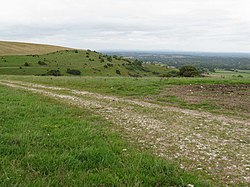
The civil parish has a land area of 1,200 hectares (3,000 acres). In the 2001 census 6074 people lived in 2778 households of whom 2563 were economically active. At the 2011 Census the population had increased to 6,966. In 2018 there was a recorded 8,955 people living in the
Storrington area.
501:
120:
313:
177:
321:
297:
586:
466:
49:
367:
259:
605:
33:
610:
290:
285:
302:
579:
349:
247:
213:
359:
113:
572:
473:
93:
354:
227:
159:
544:
203:
195:
167:
136:
103:
252:
556:
599:
278:
410:
143:
552:
438:
425:. The parish covers both the town of Storrington and the village of Sullington.
418:
401:
185:
70:
443:
405:
382:
369:
237:
422:
414:
219:
130:
530:
334:
531:
Official
Storrington & Sullington Parish Council Website
560:
330:
312:
296:
284:
272:
258:
246:
236:
226:
212:
194:
176:
158:
142:
128:
112:
101:
88:
80:
26:
56:
467:"2001 Census: West Sussex – Population by Parish"
580:
8:
472:. West Sussex County Council. Archived from
587:
573:
461:
459:
84:12.00 km (4.63 sq mi)
23:
455:
329:
311:
267:
235:
211:
127:
111:
79:
30:
496:
494:
295:
283:
271:
257:
245:
225:
193:
175:
157:
100:
7:
541:
539:
16:Civil parish in West Sussex, England
14:
543:
508:. Office for National Statistics
55:
48:
32:
502:"Civil parish population 2011"
335:http://www.storrington.org.uk/
1:
606:Civil parishes in West Sussex
559:. You can help Knowledge by
611:West Sussex geography stubs
114:OS grid reference
38:Sullington Hill,Storrington
21:Human settlement in England
627:
538:
151:Storrington and Sullington
63:Storrington and Sullington
27:Storrington and Sullington
340:
308:
268:
108:506/km (1,310/sq mi)
43:
31:
506:Neighbourhood Statistics
322:Arundel and South Downs
555:location article is a
248:Postcode district
135:43 miles (69 km)
228:Sovereign state
97:6,966 (2011 Census)
383:50.9171°N 0.45575°W
379: /
314:UK Parliament
260:Dialling code
568:
567:
409:is the name of a
398:
397:
388:50.9171; -0.45575
178:Shire county
618:
589:
582:
575:
547:
540:
518:
517:
515:
513:
498:
489:
488:
486:
484:
478:
471:
463:
394:
393:
391:
390:
389:
384:
380:
377:
376:
375:
372:
346:
303:South East Coast
222:
124:
123:
69:Location within
59:
58:
52:
36:
24:
626:
625:
621:
620:
619:
617:
616:
615:
596:
595:
594:
593:
536:
527:
522:
521:
511:
509:
500:
499:
492:
482:
480:
476:
469:
465:
464:
457:
452:
435:
387:
385:
381:
378:
373:
370:
368:
366:
365:
364:
344:
326:
218:
208:
190:
172:
154:
119:
118:
96:
76:
75:
74:
73:
67:
66:
65:
64:
60:
39:
22:
17:
12:
11:
5:
624:
622:
614:
613:
608:
598:
597:
592:
591:
584:
577:
569:
566:
565:
548:
534:
533:
526:
525:External links
523:
520:
519:
490:
479:on 8 June 2011
454:
453:
451:
448:
447:
446:
441:
434:
431:
396:
395:
363:
362:
357:
352:
347:
345:List of places
341:
338:
337:
332:
328:
327:
325:
324:
318:
316:
310:
309:
306:
305:
300:
294:
293:
288:
282:
281:
276:
270:
269:
266:
265:
262:
256:
255:
250:
244:
243:
240:
234:
233:
232:United Kingdom
230:
224:
223:
216:
210:
209:
207:
206:
200:
198:
192:
191:
189:
188:
182:
180:
174:
173:
171:
170:
164:
162:
156:
155:
153:
152:
148:
146:
140:
139:
133:
126:
125:
116:
110:
109:
106:
99:
98:
90:
86:
85:
82:
78:
77:
68:
62:
61:
54:
53:
47:
46:
45:
44:
41:
40:
37:
29:
28:
20:
15:
13:
10:
9:
6:
4:
3:
2:
623:
612:
609:
607:
604:
603:
601:
590:
585:
583:
578:
576:
571:
570:
564:
562:
558:
554:
549:
546:
542:
537:
532:
529:
528:
524:
507:
503:
497:
495:
491:
475:
468:
462:
460:
456:
449:
445:
442:
440:
437:
436:
432:
430:
426:
424:
420:
416:
412:
408:
407:
403:
392:
361:
358:
356:
353:
351:
348:
343:
342:
339:
336:
333:
323:
320:
319:
317:
315:
307:
304:
301:
299:
292:
289:
287:
280:
277:
275:
263:
261:
254:
251:
249:
241:
239:
231:
229:
221:
217:
215:
205:
202:
201:
199:
197:
187:
184:
183:
181:
179:
169:
166:
165:
163:
161:
150:
149:
147:
145:
141:
138:
134:
132:
122:
117:
115:
107:
105:
95:
91:
87:
83:
72:
51:
42:
35:
25:
19:
561:expanding it
550:
535:
510:. Retrieved
505:
481:. Retrieved
474:the original
427:
417:District of
411:civil parish
400:
399:
144:Civil parish
92:6,074
18:
553:West Sussex
439:Storrington
419:West Sussex
402:Storrington
386: /
360:West Sussex
291:West Sussex
186:West Sussex
94:2001 Census
71:West Sussex
600:Categories
450:References
444:Sullington
406:Sullington
371:50°55′02″N
242:PULBOROUGH
204:South East
89:Population
512:3 October
374:0°27′21″W
298:Ambulance
238:Post town
483:12 April
433:See also
160:District
121:TQ086142
423:England
415:Horsham
413:in the
355:England
331:Website
220:England
214:Country
168:Horsham
129:•
104:Density
102:•
279:Sussex
274:Police
196:Region
131:London
551:This
477:(PDF)
470:(PDF)
264:01903
557:stub
514:2016
485:2009
404:and
286:Fire
253:RH20
81:Area
137:NNE
602::
504:.
493:^
458:^
421:,
350:UK
588:e
581:t
574:v
563:.
516:.
487:.
Text is available under the Creative Commons Attribution-ShareAlike License. Additional terms may apply.

