29:
296:
73:
312:
193:
Striped Peak has a number of trails and roads that visitors can use to access points on the mountain. There a number of viewpoints which have views of the strait,
317:
257:
282:
248:
253:
66:
172:
194:
176:
113:
160:
243:
202:
48:
164:
56:
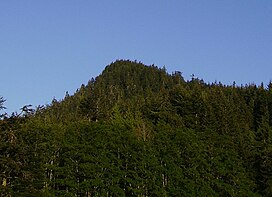
117:
278:
131:
198:
124:
171:; there are still accessible bunkers located on the mountain. To the east is located
306:
187:
180:
143:
272:
190:
due to a "landslip occurring down its face". The landslip is no longer visible.
225:
168:
28:
88:
75:
295:
167:
and rises to 1,166 feet (355 m). The mountain used to be part of
41:
294:
159:
is a mountain located approximately 12 miles (19 km) west of
186:
Striped Peak was named in 1846 by the
British naval surveyor
175:
and to the west
Crescent Bay. Also located to west is the
142:
137:
123:
109:
104:
65:
55:
40:
35:
21:
16:Mountain in Washington (state), United States
8:
18:
277:. Van Winkle Publishing Co. p. 16.
258:United States Department of the Interior
313:Mountains of Clallam County, Washington
214:
299:View of Crescent Bay from near summit
7:
220:
218:
249:Geographic Names Information System
205:, and surrounding coast and hills.
163:. It is located directly off the
14:
27:
318:Mountains of Washington (state)
254:United States Geological Survey
1:
334:
226:"Striped Peak, Washington"
195:Victoria, British Columbia
177:Salt Creek Recreation Area
46:1,166 ft (355 m)
271:Majors, Harry M. (1975).
26:
161:Port Angeles, Washington
89:48.1564774°N 123.68464°W
61:966 ft (294 m)
203:Sooke, British Columbia
300:
165:Strait of Juan de Fuca
94:48.1564774; -123.68464
298:
274:Exploring Washington
85: /
301:
49: NGVD 29
36:Highest point
284:978-0-918664-00-6
154:
153:
132:Olympic Mountains
51:
325:
289:
288:
268:
262:
261:
240:
234:
233:
222:
199:Vancouver Island
146:
127:
118:Washington, U.S.
100:
99:
97:
96:
95:
90:
86:
83:
82:
81:
78:
47:
31:
19:
333:
332:
328:
327:
326:
324:
323:
322:
303:
302:
293:
292:
285:
270:
269:
265:
242:
241:
237:
224:
223:
216:
211:
144:
125:
93:
91:
87:
84:
79:
76:
74:
72:
71:
17:
12:
11:
5:
331:
329:
321:
320:
315:
305:
304:
291:
290:
283:
263:
244:"Striped Peak"
235:
230:Peakbagger.com
213:
212:
210:
207:
173:Freshwater Bay
152:
151:
148:
140:
139:
135:
134:
129:
121:
120:
114:Clallam County
111:
107:
106:
102:
101:
69:
63:
62:
59:
53:
52:
44:
38:
37:
33:
32:
24:
23:
15:
13:
10:
9:
6:
4:
3:
2:
330:
319:
316:
314:
311:
310:
308:
297:
286:
280:
276:
275:
267:
264:
259:
255:
251:
250:
245:
239:
236:
231:
227:
221:
219:
215:
208:
206:
204:
200:
196:
191:
189:
188:Henry Kellett
184:
182:
178:
174:
170:
166:
162:
158:
149:
147:
145:Easiest route
141:
136:
133:
130:
128:
122:
119:
115:
112:
108:
103:
98:
70:
68:
64:
60:
58:
54:
50:
45:
43:
39:
34:
30:
25:
20:
273:
266:
247:
238:
229:
192:
185:
181:Tongue Point
157:Striped Peak
156:
155:
126:Parent range
22:Striped Peak
169:Camp Hayden
92: /
80:123°41′05″W
67:Coordinates
307:Categories
209:References
77:48°09′23″N
57:Prominence
105:Geography
42:Elevation
138:Climbing
110:Location
281:
279:ISBN
179:and
150:Hike
309::
256:,
252:.
246:.
228:.
217:^
201:,
197:,
183:.
116:,
287:.
260:.
232:.
Text is available under the Creative Commons Attribution-ShareAlike License. Additional terms may apply.