643:
36:
299:
498:
343:
24:
325:
232:
292:
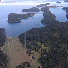
Two airstrips are located on the island. Stuart Island
Airstrip (7WA5) is a 2,000-foot (610 m) grass runway, and Stuart Island West (2WA3) is a 1,560-foot (475 m) dirt runway).
529:
690:
522:
298:
654:
515:
56:
168:. The 7.462-square-kilometer (2.881 sq mi) island is home to two communities of full and part-time residents, a state park, a
189:
404:
387:
305:
507:
379:
277:
539:
125:
592:
582:
783:
753:
735:
662:
597:
587:
561:
457:
260:
680:
347:
240:
710:
672:
235:
Stuart Island
Airpark (background) lies on the eastern shore of Prevost Harbor across from Satellite Island
120:
449:
725:
720:
200:
274:
for boaters can be found in Reid Harbor and
Prevost Harbor, with public state park facilities in each.
247:. One is located near the center of the island, and another is on the western coast, the site of the
760:
169:
740:
715:
705:
700:
165:
137:
193:
501:
383:
730:
572:
281:
248:
215:
149:
91:
35:
617:
153:
497:
632:
602:
329:
211:
185:
157:
436:
424:
777:
405:"Daily Expedition Reports, May 26, 2005, from the Sea Bird in Alaska - Stuart Island"
372:
256:
204:
612:
607:
264:
622:
554:
259:
to the island's north. Turn Point Light
Station is on land administered by the
244:
280:, which lies in Prevost Harbor on the northeast side of the island, is used by
252:
231:
161:
132:
218:
is also named after
Prevost, while Satellite Island is named after his ship.
71:
58:
324:
23:
173:
642:
481:
470:
271:
284:
as a basecamp for teen expeditions and for field trips by campers.
230:
511:
641:
439:
from the official tourism website of the State of
Washington
427:
from the official tourism website of the State of
Washington
28:
South-facing aerial view of Reid Harbor on Stuart Island
40:
Location of Stuart Island within the San Juan
Islands
192:
of 1838–42, to honor
Frederick D. Stuart, the
689:
671:
653:
571:
131:
119:
105:
97:
87:
50:
45:
371:
308:Panorama showing typical views from Turn Point.
646:Map of Washington highlighting San Juan County
263:'s Spokane District, Wenatchee Resource Area,
523:
8:
16:
530:
516:
508:
34:
15:
450:"Turn Point Light Station Improvements"
362:
255:guiding shipping in the busy waters of
101:7.462 km (2.881 sq mi)
7:
538:Municipalities and communities of
14:
496:
454:Spokane District Office Planning
341:
323:
297:
22:
403:Linda Burback (May 26, 2005).
380:University of Washington Press
1:
504:travel guide from Wikivoyage
374:Washington State Place Names
348:Pacific Northwest portal
199:Prevost Harbor is named for
541:San Juan County, Washington
370:Phillips, James W. (1971).
184:Stuart Island was named by
800:
749:
639:
552:
458:Bureau of Land Management
261:Bureau of Land Management
110:
33:
21:
425:Stuart Island State Park
249:Turn Point Light Station
241:Stuart Island State Park
239:Two sites, both part of
647:
236:
645:
437:Turn Point Lighthouse
234:
201:James Charles Prevost
762:United States portal
227:Parks and recreation
170:one-room schoolhouse
72:48.6736°N 123.2051°W
196:of the expedition.
68: /
18:
648:
330:Islands portal
237:
77:48.6736; -123.2051
771:
770:
755:Washington portal
350:
332:
190:Wilkes Expedition
143:
142:
791:
784:San Juan Islands
763:
756:
644:
564:
557:
547:
542:
532:
525:
518:
509:
500:
484:
479:
473:
468:
462:
461:
460:. July 21, 2008.
446:
440:
434:
428:
422:
416:
415:
413:
411:
400:
394:
393:
377:
367:
346:
345:
344:
339:
328:
327:
321:
301:
282:YMCA Camp Orkila
278:Satellite Island
222:Arts and culture
216:British Columbia
150:San Juan Islands
92:San Juan Islands
83:
82:
80:
79:
78:
73:
69:
66:
65:
64:
61:
38:
26:
19:
799:
798:
794:
793:
792:
790:
789:
788:
774:
773:
772:
767:
761:
754:
745:
692:
685:
667:
649:
637:
574:
567:
562:
555:
548:
545:
540:
536:
493:
488:
487:
480:
476:
469:
465:
448:
447:
443:
435:
431:
423:
419:
409:
407:
402:
401:
397:
390:
369:
368:
364:
359:
342:
340:
322:
316:
311:
310:
309:
307:
302:
290:
229:
224:
194:captain's clerk
182:
154:San Juan Island
115:
76:
74:
70:
67:
62:
59:
57:
55:
54:
41:
29:
12:
11:
5:
797:
795:
787:
786:
776:
775:
769:
768:
766:
765:
758:
750:
747:
746:
744:
743:
738:
733:
728:
723:
718:
713:
708:
703:
697:
695:
687:
686:
684:
683:
677:
675:
669:
668:
666:
665:
659:
657:
651:
650:
640:
638:
636:
635:
630:
625:
620:
615:
610:
605:
600:
595:
590:
585:
579:
577:
569:
568:
553:
550:
549:
537:
535:
534:
527:
520:
512:
506:
505:
492:
491:External links
489:
486:
485:
474:
463:
441:
429:
417:
395:
388:
361:
360:
358:
355:
354:
353:
335:
315:
312:
304:
303:
296:
295:
294:
289:
288:Infrastructure
286:
228:
225:
223:
220:
212:Prevost Island
186:Charles Wilkes
181:
178:
158:Waldron Island
148:is one of the
141:
140:
135:
129:
128:
123:
117:
116:
111:
108:
107:
106:Administration
103:
102:
99:
95:
94:
89:
85:
84:
52:
48:
47:
43:
42:
39:
31:
30:
27:
13:
10:
9:
6:
4:
3:
2:
796:
785:
782:
781:
779:
764:
759:
757:
752:
751:
748:
742:
739:
737:
736:Orcas Village
734:
732:
729:
727:
724:
722:
719:
717:
714:
712:
709:
707:
704:
702:
699:
698:
696:
694:
688:
682:
679:
678:
676:
674:
670:
664:
663:Friday Harbor
661:
660:
658:
656:
652:
634:
631:
629:
626:
624:
621:
619:
616:
614:
611:
609:
606:
604:
601:
599:
596:
594:
591:
589:
586:
584:
581:
580:
578:
576:
570:
566:
565:
563:Friday Harbor
558:
551:
546:United States
543:
533:
528:
526:
521:
519:
514:
513:
510:
503:
502:Stuart Island
499:
495:
494:
490:
483:
478:
475:
472:
467:
464:
459:
455:
451:
445:
442:
438:
433:
430:
426:
421:
418:
406:
399:
396:
391:
389:0-295-95158-3
385:
381:
376:
375:
366:
363:
356:
352:
351:
349:
336:
334:
333:
331:
326:
318:
317:
313:
306:
300:
293:
287:
285:
283:
279:
275:
273:
268:
266:
262:
258:
257:Boundary Pass
254:
250:
246:
242:
233:
226:
221:
219:
217:
213:
209:
208:
203:, captain of
202:
197:
195:
191:
187:
179:
177:
175:
171:
167:
163:
159:
155:
151:
147:
146:Stuart Island
139:
136:
134:
130:
127:
124:
122:
118:
114:
113:United States
109:
104:
100:
96:
93:
90:
86:
81:
53:
49:
44:
37:
32:
25:
20:
17:Stuart Island
681:Roche Harbor
627:
560:
477:
466:
453:
444:
432:
420:
408:. Retrieved
398:
373:
365:
338:
337:
320:
319:
291:
276:
269:
265:Lopez Island
245:public lands
238:
206:
198:
183:
156:and west of
145:
144:
112:
711:Deer Harbor
693:communities
556:County seat
188:during the
152:, north of
88:Archipelago
75: /
63:123°12′18″W
51:Coordinates
357:References
272:anchorages
270:Sheltered
253:lighthouse
172:, and two
166:Washington
162:U.S. state
138:Washington
60:48°40′25″N
726:Islandale
721:Eastsound
573:Populated
243:, are on
210:. Nearby
207:Satellite
205:HMS
174:airstrips
46:Geography
778:Category
618:San Juan
314:See also
267:Office.
126:San Juan
741:Rosario
716:Doe Bay
706:Decatur
633:Waldron
603:Decatur
583:Blakely
575:islands
410:June 7,
180:History
160:in the
701:Argyle
628:Stuart
593:Center
482:AirNav
471:AirNav
386:
121:County
691:Other
613:Orcas
608:Lopez
598:Crane
588:Brown
133:State
731:Olga
655:Town
623:Shaw
412:2009
384:ISBN
251:, a
98:Area
673:CDP
214:in
176:.
164:of
780::
559::
544:,
456:.
452:.
382:.
378:.
531:e
524:t
517:v
414:.
392:.
Text is available under the Creative Commons Attribution-ShareAlike License. Additional terms may apply.