156:
204:
216:
49:. Wilderness permits are not required to hike the peak, but a Forest Service pass is required to park on any fire road. Sugarloaf Mountain is clearly visible in most parts of Big Bear Valley. The peak is especially prominent when entering the Big Bear area from Highway 18 from the Lucerne Valley. Located in a unique transition zone in Southern California, the climate is influenced by the deserts, the inland valley, and alpine climates. The north face of the summit is usually covered with snow during the winter months.
120:
168:
140:
192:
27:
180:
57:
The flora and fauna of
Sugarloaf Mountain are representative of a transitional zone between inland desert, mountain, and inland valley climates. The mountain and surrounding forests are home to many rare and endemic plant species. Looming 3,000 feet (910 m) over the southern part of the Big Bear
107:
removed most of the burros from the
Sugarloaf area, but some animals travel there from the lower deserts. Cougars and bears have been spotted in the forests to the west of the peak. In late spring, butterflies may be seen at the rock scree close to the summit.
94:
bushes and extensive rock scree, with a few hardy
Jeffery pines. Snow rarely stays more than few days once the sun shines on the southern face, while the much cooler northern face is covered with snow from early December to late May.
98:
A year-round spring on the north face forms a small creek that travels to the
Greenspot Meadows, which is an excellent birding spot during the spring and summer. The northern slopes were formerly home to herds of wild
155:
203:
119:
139:
167:
191:
215:
269:
45:. With a peak elevation of 9,952 feet (3,033 m), it is the highest peak in the San Bernardino Mountains outside the
82:
formations. The forest on the east facing slope is drier, and the vegetation shows the influence of the Mojave Desert;
104:
38:
46:
179:
250:
59:
20:
42:
26:
130:
75:
239:
263:
146:
63:
126:
71:
62:, the northern slopes of the mountain are heavily forested with second-growth
91:
90:
are more dominant. The southern slope of the mountain is covered in scrubby
83:
79:
67:
30:
Sugarloaf from
Highway 38, April 2006. Sugarloaf is the peak on the right.
161:
Looking 3,000 feet (910 m) down into Big Bear Valley from the summit
209:
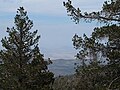
The Mojave Desert is in the distance looking north-east from the summit
87:
173:
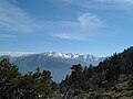
View of Mt. San
Gorgonio to the south from the saddle of Sugarloaf
100:
25:
19:
For other mountains called "Sugarloaf" or "Sugar Loaf", see
16:
Mountain of the San
Bernardino Mountains in California
103:
that could be seen from
Wildhorse Meadows Road. The
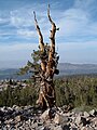
70:. At higher altitudes on the north-facing slope,
145:Weather-beaten limber pine near the summit. The
197:View of north face from the town of Sugarloaf
8:
251:"Sugarloaf Mountain – A Sweet Way to Go"
232:
115:
253:, Los Angeles Times, October 17, 1987.
133:500 feet (150 m) below the summit
7:
14:
78:near the summit are twisted into
37:is a large prominent peak in the
214:
202:
190:
178:
166:
154:
138:
118:
1:
286:
58:Valley and the village of
18:
221:Hiking towards the summit
105:Bureau of Land Management
270:San Bernardino Mountains
39:San Bernardino Mountains
47:San Gorgonio Wilderness
31:
149:is in the background.
29:
21:Sugarloaf (mountain)
43:Southern California
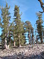
125:Rocky slopes with
35:Sugarloaf Mountain
32:
185:Wildhorse Meadows
277:
254:
248:
242:
237:
218:
206:
194:
182:
170:
158:
142:
122:
285:
284:
280:
279:
278:
276:
275:
274:
260:
259:
258:
257:
249:
245:
238:
234:
229:
222:
219:
210:
207:
198:
195:
186:
183:
174:
171:
162:
159:
150:
143:
134:
131:Lodgepole Pines
123:
114:
76:Lodgepole Pines
55:
53:Flora and fauna
24:
17:
12:
11:
5:
283:
281:
273:
272:
262:
261:
256:
255:
243:
240:summitpost.org
231:
230:
228:
225:
224:
223:
220:
213:
211:
208:
201:
199:
196:
189:
187:
184:
177:
175:
172:
165:
163:
160:
153:
151:
144:
137:
135:
124:
117:
113:
110:
54:
51:
15:
13:
10:
9:
6:
4:
3:
2:
282:
271:
268:
267:
265:
252:
247:
244:
241:
236:
233:
226:
217:
212:
205:
200:
193:
188:
181:
176:
169:
164:
157:
152:
148:
147:Mojave Desert
141:
136:
132:
128:
121:
116:
111:
109:
106:
102:
96:
93:
89:
85:
81:
77:
73:
69:
65:
61:
52:
50:
48:
44:
40:
36:
28:
22:
246:
235:
97:
64:Jeffrey Pine
56:
34:
33:
227:References
68:White Firs
92:manzanita
84:sagebrush
80:Krummholz
60:Sugarloaf
264:Category
88:junipers
112:Gallery
127:Limber
101:burros
72:Limber
129:and
86:and
74:and
66:and
41:in
266::
23:.
Text is available under the Creative Commons Attribution-ShareAlike License. Additional terms may apply.