436:
339:
29:
534:
There are 583 bodies of water in the basin area. The largest of them is the
Letovice Reservoir with an area of 98 ha (240 acres), built on the Křetínka. Two fishponds are built on the upper course of the Svitava.
435:
446:
The river valley is densely populated and there are many relatively notable settlements on the river. Apart from the city of Brno, the most significant towns on the river are
738:
733:
568:
713:
728:
338:
156:
358:, where it enters the Svratka River at an elevation of 191 m (627 ft). It is 98.4 km (61.1 mi) long. Its
57:
463:
519:
28:
588:
523:
503:
507:
305:
70:
495:
455:
685:
326:
709:
552:
301:
65:
351:
297:
277:
248:
142:
106:
499:
454:, named after the river. The river flows through the municipal territories of Svitavy,
359:
289:
256:
50:
640:
722:
616:
511:
515:
661:
543:
There are a large number of mills and hydroelectric power stations on the river.
592:
487:
475:
471:
127:
559:
on it. The most popular section for paddlers is between
Letovice and Blansko.
467:
171:
158:
491:
321:
293:
264:
483:
459:
440:
479:
451:
447:
347:
102:
399:
260:
434:
337:
316:
The river's name referred to its clear water and was derived from
285:
252:
556:
355:
34:
555:. The river is navigable all year round, but there are many
354:
at the elevation of 472 m (1,549 ft) and flows to
362:
has an area of 1,149.4 km (443.8 sq mi).
641:"Základní charakteristiky toku Svitava a jeho povodí"
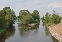
439:Counfluence of the Svitava (right) and Křetínka in
244:
239:
225:
217:
205:
197:
187:
148:
136:
126:
112:
96:
88:
79:
56:
46:
41:
21:
643:(in Czech). T. G. Masaryk Water Research Institute
231:5.22 m/s (184 cu ft/s) near estuary
308:regions. It is 98.4 km (61.1 mi) long.
712:– Flood Warning and Forecasting Service of the
342:Confluence of the Svitava (right) and Svratka
8:
365:The longest tributaries of the Svitava are:
710:River flow at Bílovice nad Svitavou station
346:The Svitava originates in the territory of
324:. The river is first documented in 1125 in
589:"Svitavy: městu dala jméno průzračná řeka"
635:
633:
611:
609:
680:
678:
367:
580:
209:1,149.4 km (443.8 sq mi)
16:River in South Moravian, Czech Republic
18:
7:
569:List of rivers of the Czech Republic
739:Rivers of the South Moravian Region
714:Czech Hydrometeorological Institute
14:
27:
734:Rivers of the Pardubice Region
688:(in Czech). Pádler. 2017-11-10
150: • coordinates
1:
80:Physical characteristics
551:The Svitava is suitable for
300:River. It flows through the
189: • elevation
114: • elevation
201:98.4 km (61.1 mi)
138: • location
98: • location
755:
686:"Svitava – řeka plná jezů"
320:, which meant " clear" in
227: • average
118:472 m (1,549 ft)
619:(in Czech). Město Svitavy
235:
213:
122:
84:
26:
729:Tributaries of the Thaya
664:(in Czech). CzechTourism
193:191 m (627 ft)
504:Doubravice nad Svitavou
443:
343:
281:
524:Bílovice nad Svitavou
438:
341:
172:49.14222°N 16.62833°E
496:Skalice nad Svitavou
464:Březová nad Svitavou
456:Hradec nad Svitavou
240:Basin features
168: /
444:
344:
177:49.14222; 16.62833
428:
427:
327:Chronica Boemorum
270:
269:
746:
697:
696:
694:
693:
682:
673:
672:
670:
669:
658:
652:
651:
649:
648:
637:
628:
627:
625:
624:
613:
604:
603:
601:
600:
585:
368:
228:
183:
182:
180:
179:
178:
173:
169:
166:
165:
164:
161:
115:
99:
31:
19:
754:
753:
749:
748:
747:
745:
744:
743:
719:
718:
706:
701:
700:
691:
689:
684:
683:
676:
667:
665:
660:
659:
655:
646:
644:
639:
638:
631:
622:
620:
615:
614:
607:
598:
596:
587:
586:
582:
577:
565:
549:
541:
532:
530:Bodies of water
433:
352:Svitavy Uplands
336:
314:
226:
190:
176:
174:
170:
167:
162:
159:
157:
155:
154:
151:
139:
113:
107:Svitavy Uplands
97:
75:
37:
33:The Svitava in
17:
12:
11:
5:
752:
750:
742:
741:
736:
731:
721:
720:
717:
716:
705:
704:External links
702:
699:
698:
674:
662:"Řeka Svitava"
653:
629:
605:
579:
578:
576:
573:
572:
571:
564:
561:
548:
545:
540:
537:
531:
528:
508:Rájec-Jestřebí
500:Lhota Rapotina
432:
429:
426:
425:
422:
419:
416:
412:
411:
408:
405:
402:
396:
395:
392:
389:
386:
382:
381:
378:
375:
372:
360:drainage basin
335:
334:Characteristic
332:
313:
310:
306:South Moravian
290:Czech Republic
268:
267:
246:
242:
241:
237:
236:
233:
232:
229:
223:
222:
219:
215:
214:
211:
210:
207:
203:
202:
199:
195:
194:
191:
188:
185:
184:
152:
149:
146:
145:
140:
137:
134:
133:
130:
124:
123:
120:
119:
116:
110:
109:
100:
94:
93:
90:
86:
85:
82:
81:
77:
76:
74:
73:
71:South Moravian
68:
62:
60:
54:
53:
51:Czech Republic
48:
44:
43:
39:
38:
32:
24:
23:
15:
13:
10:
9:
6:
4:
3:
2:
751:
740:
737:
735:
732:
730:
727:
726:
724:
715:
711:
708:
707:
703:
687:
681:
679:
675:
663:
657:
654:
642:
636:
634:
630:
618:
612:
610:
606:
594:
590:
584:
581:
574:
570:
567:
566:
562:
560:
558:
554:
553:river tourism
546:
544:
538:
536:
529:
527:
525:
521:
517:
513:
509:
505:
501:
497:
493:
489:
485:
481:
477:
473:
469:
465:
461:
457:
453:
449:
442:
437:
430:
423:
420:
417:
414:
413:
409:
406:
403:
401:
398:
397:
393:
390:
387:
384:
383:
379:
376:
373:
370:
369:
366:
363:
361:
357:
353:
349:
340:
333:
331:
329:
328:
323:
319:
311:
309:
307:
303:
299:
295:
291:
287:
283:
279:
275:
266:
262:
258:
254:
250:
247:
243:
238:
234:
230:
224:
220:
216:
212:
208:
204:
200:
196:
192:
186:
181:
153:
147:
144:
141:
135:
131:
129:
125:
121:
117:
111:
108:
104:
101:
95:
91:
87:
83:
78:
72:
69:
67:
64:
63:
61:
59:
55:
52:
49:
45:
40:
36:
30:
25:
20:
690:. Retrieved
666:. Retrieved
656:
645:. Retrieved
621:. Retrieved
597:. Retrieved
595:. 2014-09-17
591:(in Czech).
583:
550:
542:
533:
445:
364:
345:
325:
317:
315:
273:
271:
593:Czech Radio
514:, Blansko,
431:Settlements
374:Length (km)
245:Progression
175: /
723:Categories
692:2023-10-27
668:2023-10-27
647:2023-10-27
623:2023-10-27
617:"Historie"
599:2021-10-14
575:References
526:and Brno.
206:Basin size
163:16°37′42″E
516:Olomučany
492:Boskovice
371:Tributary
322:Old Czech
312:Etymology
302:Pardubice
294:tributary
292:, a left
265:Black Sea
218:Discharge
160:49°8′32″N
66:Pardubice
563:See also
488:Svitávka
484:Letovice
476:Stvolová
472:Rozhraní
441:Letovice
385:Křetínka
377:River km
282:Zwittawa
42:Location
547:Tourism
512:Ráječko
480:Skrchov
468:Brněnec
452:Svitavy
448:Blansko
350:in the
348:Svitavy
298:Svratka
296:of the
288:in the
284:) is a
274:Svitava
249:Svratka
143:Svratka
103:Svitavy
58:Regions
47:Country
22:Svitava
520:Adamov
400:Punkva
394:right
318:svítat
278:German
261:Danube
257:Morava
221:
198:Length
132:
92:
89:Source
557:weirs
460:Banín
424:left
410:left
380:Side
286:river
253:Thaya
128:Mouth
450:and
421:49.5
418:21.3
415:Bělá
407:32.9
404:29.0
391:66.4
388:31.4
356:Brno
304:and
272:The
35:Brno
539:Use
725::
677:^
632:^
608:^
522:,
518:,
510:,
506:,
502:,
498:,
494:,
490:,
486:,
482:,
478:,
474:,
470:,
466:,
462:,
458:,
330:.
280::
263:→
259:→
255:→
251:→
105:,
695:.
671:.
650:.
626:.
602:.
276:(
Text is available under the Creative Commons Attribution-ShareAlike License. Additional terms may apply.