389:). As a result, the west side of the North Cascades experiences higher precipitation than the east side, especially during the winter months in the form of snowfall. During winter months, weather is usually cloudy, but, due to high pressure systems over the Pacific Ocean that intensify during summer months, there is often little or no cloud cover during the summer. The months July through September offer the most favorable weather, and the Forest Service access road being open for the season. However, smoke from distant wildfires may potentially reduce visibility, and smoky summer conditions have been increasing with climate change.
139:
179:
146:
172:
470:
29:
447:
period dating back over two million years ago, glaciation advancing and retreating repeatedly scoured the landscape leaving deposits of rock debris. The U-shaped cross section of the river valleys is a result of recent glaciation.
94:
405:. Geological events occurring many years ago created the diverse topography and drastic elevation changes over the Cascade Range leading to the various climate differences.
649:
654:
138:
171:
644:
385:, they are forced upward by the peaks of the Cascade Range, causing them to drop their moisture in the form of rain or snowfall onto the Cascades (
330:
664:
456:
in combination with glaciation have been the dominant processes which have created the tall peaks and deep valleys of the North
Cascades area.
490:
485:
251:
624:
87:
310:
208:
338:
314:
212:
639:
429:
318:
295:
659:
584:
64:
54:
77:
574:
Beckey, Fred W. Cascade Alpine Guide, Climbing and High Routes. Seattle, WA: Mountaineers Books, 2008.
413:
345:
traverses the east slope of the peak, with an off-trail scramble to reach the summit. Precipitation
425:
408:
The history of the formation of the
Cascade Mountains dates back millions of years ago to the late
342:
266:
216:
378:
475:
453:
386:
246:
437:
402:
382:
346:
326:
322:
235:
231:
224:
633:
417:
398:
374:
370:
239:
69:
354:
350:
309:
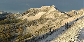
is a 7,560-foot (2,300-metre) mountain summit located on the shared border between
287:
585:"Paul Lindholdt: Wildfires signal climate in calamity | the Spokesman-Review"
517:
444:
349:
from
Syncline Mountain drains east into Trout Creek which is a tributary of the
28:
465:
334:
298:
109:
96:
271:
337:, 0.8 miles (1.3 km) to the north, and the nearest higher neighbor is
358:
357:
drainage basin. This unofficially named mountain features a conspicuous
449:
433:
421:
397:
The North
Cascades features some of the most rugged topography in the
538:
409:
44:
275:
353:, or northwest into Slate Creek, which is part of the
286:
281:
265:
260:
245:
223:
204:
125:
86:
76:
63:
53:
43:
38:
21:
424:persisted. In addition, small fragments of the
533:
531:
16:Mountain in Washington (state), United States
8:
600:
598:
596:
594:
401:with craggy peaks, spires, ridges, and deep
341:, 2.1 miles (3.4 km) to the west. The
158:Location of Syncline Mountain in Washington
607:The Natural History of Puget Sound Country
18:
329:, and is situated on land managed by the
178:
145:
650:Mountains of Okanogan County, Washington
655:Mountains of Whatcom County, Washington
502:
191:Syncline Mountain (the United States)
7:
512:
510:
508:
506:
565:, The Mountaineers, 1999, pg. 122.
561:Rowland Tabor and Ralph Haugerud,
377:, and travel northeast toward the
331:Okanogan–Wenatchee National Forest
14:
609:. University of Washington Press.
539:""Syncline Mountain" - 7,580' WA"
491:Geology of the Pacific Northwest
468:
177:
170:
144:
137:
27:
645:Mountains of Washington (state)
518:"Syncline Mountain, Washington"
486:Geography of the North Cascades
361:, hence its descriptive name.
325:, which is a sub-range of the
161:Show map of Washington (state)
1:
665:North American 2000 m summits
563:Geology of the North Cascades
194:Show map of the United States
440:about 50 million years ago.
49:7,560 ft (2,300 m)
605:Kruckeberg, Arthur (1991).
333:. Its nearest neighbor is
82:2.08 mi (3.35 km)
681:
59:1,360 ft (410 m)
422:volcanic igneous activity
381:. As fronts approach the
321:state. It is part of the
130:
26:
625:National Weather Service
110:48.687141°N 120.712081°W
430:continental lithosphere
115:48.687141; -120.712081
33:North aspect from PCT
414:North American Plate
343:Pacific Crest Trail
106: /
623:Weather forecast:
39:Highest point
379:Cascade Mountains
373:originate in the
307:Syncline Mountain
304:
303:
185:Syncline Mountain
152:Syncline Mountain
22:Syncline Mountain
672:
611:
610:
602:
589:
588:
581:
575:
572:
566:
559:
553:
552:
550:
549:
535:
526:
525:
514:
478:
476:Mountains portal
473:
472:
471:
412:Epoch. With the
294:Harts Pass, PCT
290:
227:
195:
181:
180:
174:
162:
148:
147:
141:
121:
120:
118:
117:
116:
111:
107:
104:
103:
102:
99:
31:
19:
680:
679:
675:
674:
673:
671:
670:
669:
630:
629:
620:
615:
614:
604:
603:
592:
583:
582:
578:
573:
569:
560:
556:
547:
545:
543:listsofjohn.com
537:
536:
529:
516:
515:
504:
499:
482:
481:
474:
469:
467:
462:
416:overriding the
403:glacial valleys
395:
387:Orographic lift
367:
311:Okanogan County
288:
238:
234:
225:
215:
209:Okanogan County
200:
199:
198:
197:
196:
193:
192:
189:
188:
187:
186:
182:
165:
164:
163:
160:
159:
156:
155:
154:
153:
149:
114:
112:
108:
105:
100:
97:
95:
93:
92:
34:
17:
12:
11:
5:
678:
676:
668:
667:
662:
657:
652:
647:
642:
640:North Cascades
632:
631:
628:
627:
619:
618:External links
616:
613:
612:
590:
576:
567:
554:
527:
522:Peakbagger.com
501:
500:
498:
495:
494:
493:
488:
480:
479:
464:
463:
461:
458:
438:North Cascades
420:, episodes of
394:
391:
383:North Cascades
371:weather fronts
366:
363:
327:North Cascades
323:Okanogan Range
315:Whatcom County
302:
301:
292:
284:
283:
279:
278:
269:
263:
262:
258:
257:
249:
243:
242:
236:North Cascades
232:Okanogan Range
229:
221:
220:
213:Whatcom County
206:
202:
201:
190:
184:
183:
176:
175:
169:
168:
167:
166:
157:
151:
150:
143:
142:
136:
135:
134:
133:
132:
131:
128:
127:
123:
122:
90:
84:
83:
80:
74:
73:
67:
61:
60:
57:
51:
50:
47:
41:
40:
36:
35:
32:
24:
23:
15:
13:
10:
9:
6:
4:
3:
2:
677:
666:
663:
661:
660:Cascade Range
658:
656:
653:
651:
648:
646:
643:
641:
638:
637:
635:
626:
622:
621:
617:
608:
601:
599:
597:
595:
591:
586:
580:
577:
571:
568:
564:
558:
555:
544:
540:
534:
532:
528:
523:
519:
513:
511:
509:
507:
503:
496:
492:
489:
487:
484:
483:
477:
466:
459:
457:
455:
451:
446:
441:
439:
435:
431:
427:
423:
419:
418:Pacific Plate
415:
411:
406:
404:
400:
399:Cascade Range
392:
390:
388:
384:
380:
376:
375:Pacific Ocean
372:
364:
362:
360:
356:
352:
348:
344:
340:
339:Mount Ballard
336:
332:
328:
324:
320:
316:
312:
308:
300:
297:
293:
291:
289:Easiest route
285:
280:
277:
273:
270:
268:
264:
259:
256:
253:
250:
248:
244:
241:
240:Cascade Range
237:
233:
230:
228:
222:
218:
214:
210:
207:
203:
173:
140:
129:
124:
119:
91:
89:
85:
81:
79:
75:
71:
70:Pasayten Peak
68:
66:
62:
58:
56:
52:
48:
46:
42:
37:
30:
25:
20:
606:
579:
570:
562:
557:
546:. Retrieved
542:
521:
442:
436:created the
407:
396:
368:
355:Skagit River
351:Methow River
306:
305:
296:class 2
267:Type of rock
254:
226:Parent range
445:Pleistocene
443:During the
113: /
101:120°42′43″W
88:Coordinates
65:Parent peak
634:Categories
548:2020-07-23
497:References
335:Tatie Peak
319:Washington
299:scrambling
255:Slate Peak
217:Washington
98:48°41′14″N
72:(7,850 ft)
55:Prominence
272:sandstone
126:Geography
78:Isolation
45:Elevation
460:See also
454:faulting
434:terranes
359:syncline
282:Climbing
247:Topo map
205:Location
432:called
426:oceanic
393:Geology
365:Climate
261:Geology
450:Uplift
410:Eocene
347:runoff
219:, U.S.
369:Most
276:shale
452:and
428:and
313:and
252:USGS
317:in
636::
593:^
541:.
530:^
520:.
505:^
274:,
211:/
587:.
551:.
524:.
Text is available under the Creative Commons Attribution-ShareAlike License. Additional terms may apply.