47:
38:
1517:
1145:
1505:
976:
406:. Average temperatures range from 5 °C (41 °F) in January to 30 °C (86 °F) in July. Annual average precipitation is 300 millimetres (12 in), but ranges from a minimum of 141 millimetres (5.6 in) per year in dry years to 424 millimetres (16.7 in) per year in exceptionally wet years. Although much of the area is cultivated today, combined
360:
is 4.1 cubic metres (140 cu ft) per second. Maximum discharge, occurring in the months
February and March, is 7 cubic metres (250 cu ft) per second, while minimum discharge, recorded for June–October, is 1.4 cubic metres (49 cu ft) per second. Average annual discharge is
455:
purposes. Since the 19th century, occupation in and cultivation of the Sajur basin have steadily increased, especially in the western, more fertile part of the area. The introduction of motorized pumps has led to a considerable decrease of the groundwater table, with the effect that many wells have
401:
in the north, west and south, the Manbij Plain slopes down to 420 metres (1,380 ft) amsl toward the east. In the western part of the drainage basin, flat grounds with fertile red-brown soils can be found, and this area is suitable for agriculture. Toward the east and along the Sajur, the plain
381:
a total area of 2,042 square kilometres (788 sq mi). The Syrian part of the Sajur basin – the Manbij Plain – has been particularly well-studied. This area is bounded on the north by the Syro–Turkish border and extends as far south as Manbij. To the west, the Manbij Plain is bordered by
361:
0.14 cubic kilometres (0.03 cu mi). Both in terms of length, as well as discharge, the Sajur is the smallest of the three rivers that join the
Euphrates on Syrian soil – the other two being the
397:
outcrops force the
Euphrates into the gorge of Qara Quzaq. These outcrops reach a height of 80–100 metres (260–330 ft) over the plain. Reaching heights of 500–520 metres (1,640–1,710 ft)
312:
The Sajur River is 108 kilometres (67 mi) long, of which 60 kilometres (37 mi) in Turkey and 48 kilometres (30 mi) in Syria. It is thought to originate in a place to the west of
300:. It is the smallest of the three rivers joining the Euphrates in Syria, and the only one that joins the Euphrates on its western bank. Occupation in the Sajur basin started in the
760:
369:. The Sajur is also the only river in Syria that enters the Euphrates on its right bank; both the Balikh and the Khabur flow into the Euphrates on the left bank.
464:
with a surface area of 11 square kilometres (4.2 sq mi). From this reservoir, an area of 200 square kilometres (77 sq mi) is irrigated. A
1568:
468:
with a planned reservoir capacity of 0.0098 cubic kilometres (0.0024 cu mi) is under construction on the Syrian part of the Sajour. The city of
1133:
785:
Holocene settlement in north Syria: résultats de deux prospections archéologiques effectuées dans la région du nahr Sajour et sur le haut
Euphrate syrien
542:
1111:
964:
1563:
942:
402:
is dissected by numerous wadis, making these parts of the area less suitable for human occupation and agriculture. The Manbij Plain experiences a
356:
Plain that is between 20 and 100 metres (66 and 328 ft) below the level of the plain, and up to 500 metres (1,600 ft) wide. Average
348:. The river then continues in a roughly easterly direction until it joins the Euphrates on its right bank in the area that is flooded by the
1558:
867:
481:
915:
885:
810:
792:
704:
156:
1126:
344:
black-flowing), regaining its original name Sajur shortly after. From there, the Sajur flows southeast until it crosses the
957:
460:
on the
Ayfinar Deresi, one of the two streams that join to form the Sajur. This 45-metre (148 ft) high dam creates a
1294:
1553:
1299:
1548:
1119:
1188:
1543:
1149:
1023:
950:
846:
1203:
345:
980:
1337:
894:
Muhesen, Sultan (2002), "The
Earliest Paleolithic Occupation in Syria", in Akazawa, Takeru; Aoki, Kenichi;
265:
1208:
803:
Le partage des eaux entre la Syrie, l'Irak et la
Turquie. Négociation, sécurité et asymétrie des pouvoirs
1347:
357:
435:
Occupation of the Sajur river basin started as early as the Lower
Palaeolithic period, as evidenced by
1387:
398:
1327:
403:
1488:
1279:
1058:
783:
Besançon, Jacques; Sanlaville, Paul (1985), "Le milieu géographique", in
Sanlaville, Paul (ed.),
440:
366:
1382:
1314:
996:
932:
911:
881:
863:
840:
806:
788:
301:
1362:
1357:
924:
903:
772:
281:
27:
1521:
1218:
276:
256:
72:
1246:
1183:
1342:
1332:
1284:
1238:
1155:
1008:
986:
895:
856:
820:
710:
457:
378:
787:, BAR International Series (in French), vol. 328, Oxford: B.A.R., pp. 7–40,
46:
37:
1537:
1509:
1432:
1397:
1372:
1322:
1173:
1100:
1018:
1004:
1483:
1447:
1422:
1417:
1412:
1402:
1178:
1095:
1054:
1038:
1028:
362:
1193:
1475:
1437:
1427:
1377:
1304:
1289:
1251:
1213:
1198:
1012:
407:
349:
125:
103:
51:
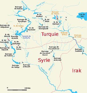
Map (in French) of the Syro–Turkish part of the
Euphrates basin with the Sajur (
1465:
1407:
1392:
1352:
1261:
452:
936:
171:
158:
1455:
1223:
1165:
1046:
907:
776:
461:
436:
394:
313:
293:
130:
113:
1367:
1228:
423:
414:
410:, climate and vegetation research suggest that the basin would support a
387:
1274:
1269:
390:
501:
1460:
1144:
1090:
1064:
469:
383:
353:
289:
89:
1080:
975:
858:
The Euphrates River and the Southeast Anatolia Development Project
411:
297:
142:
93:
878:
Village on the Euphrates. From foraging to farming at Abu Hureyra
543:"Kâmil Ocak Stadyum Meydanı'nın Veya Çıksorut'un Eski Adı Neydi?"
1085:
472:
disposes part of its wastewater into the Sajur drainage system.
1115:
946:
465:
418:
761:"Aperçu géomorpholoqique sur la vallée de l' Euphrate syrien"
336:
tannery stream). As it leaves the old town dirty, it becomes
288:) is a 108 kilometres (67 mi) long river originating in
929:
The Seven Great Monarchies of the Ancient Eastern World
591:
589:
587:
352:
reservoir. In Syria, the river cuts a valley into the
427:(rose/plum family) in the absence of human activity.
742:
270:
1474:
1446:
1313:
1260:
1237:
1164:
1073:
1037:
995:
524:
522:
451:Both Turkey and Syria use water from the Sajur for
235:
225:
215:
207:
195:
187:
148:
136:
124:
119:
109:
99:
85:
80:
60:
21:
876:Moore, A.M.T.; Hillman, G.C.; Legge, A.J. (2000),
855:
691:
667:
643:
631:
619:
595:
578:
655:
324:in the historic outskirts of Gaziantep, then to
854:Kolars, John F.; Mitchell, William A. (1991),
607:
528:
1127:
958:
900:Neandertals and Modern Humans in Western Asia
819:Kaisi, A.; Yasser, M.; Mahrouseh, Y. (n.d.),
8:
64:
341:
333:
1134:
1120:
1112:
965:
951:
943:
805:, Moyen-Orient (in French), Paris: CNRS,
566:
679:
493:
931:, vol. 2, New York: J.W. Lovell,
838:
730:
18:
902:, New York: Kluwer, pp. 95–105,
759:Besançon, J.; Sanlaville, P. (1981),
275:
7:
386:outcrops; probably the remains of a
221:4.1 m/s (140 cu ft/s)
880:, Oxford: Oxford University Press,
822:Syrian Arab Republic Country Report
443:artefacts have been found as well.
260:
231:1.4 m/s (49 cu ft/s)
199:2,042 km (788 sq mi)
65:
1569:Tributaries of the Euphrates River
743:Kaisi, Yasser & Mahrouseh n.d.
304:period and continues until today.
241:7 m/s (250 cu ft/s)
14:
502:"Geçmişten Bugüne Oğuzeli Tarihi"
393:. In the southeast of the plain,
1516:
1515:
1503:
1143:
974:
709:, www.dsi.gov.tr, archived from
320:in Turkish. Its name changes to
45:
36:
1564:Landforms of Gaziantep Province
656:Moore, Hillman & Legge 2000
456:dried up. Turkey has built the
692:Besançon & Sanlaville 1985
668:Besançon & Sanlaville 1981
644:Besançon & Sanlaville 1985
632:Besançon & Sanlaville 1985
620:Besançon & Sanlaville 1981
596:Besançon & Sanlaville 1985
579:Besançon & Sanlaville 1985
328:in the old town, and later to
150: • coordinates
1:
482:Tigris–Euphrates river system
120:Physical characteristics
1559:International rivers of Asia
271:
138: • location
1585:
608:Kolars & Mitchell 1991
529:Kolars & Mitchell 1991
277:[næhræssæːˈd͡ʒuːr]
237: • maximum
227: • minimum
217: • average
16:Tributary of the Euphrates
1497:
862:, Carbondale: SIU Press,
245:
203:
44:
35:
1280:Karamenderes (Scamander)
1024:Nahr al-Kabir al-Shamali
191:108 km (67 mi)
908:10.1007/0-306-47153-1_7
777:10.3406/paleo.1981.4295
801:Daoudy, Marwa (2005),
285:
417:vegetation with open
292:and flowing into the
172:36.65972°N 38.07056°E
845:: CS1 maint: year (
441:Middle Palaeolithic
404:continental climate
346:Syria–Turkey border
168: /
1554:Aleppo Governorate
1189:Kızılırmak (Halys)
828:, pp. 251–264
610:, pp. 108–109
569:, pp. 137–138
302:Lower Palaeolithic
177:36.65972; 38.07056
1531:
1530:
1510:Turkey portal
1456:Fırat (Euphrates)
1398:Mezitli (Liparis)
1315:Mediterranean Sea
1109:
1108:
925:Rawlinson, George
869:978-0-8093-1572-7
439:stone artefacts.
269:
249:
248:
30:
1576:
1549:Rivers of Turkey
1519:
1518:
1508:
1507:
1506:
1252:Susurluk (Simav)
1159:
1158:
1150:Rivers of Turkey
1148:
1147:
1136:
1129:
1122:
1113:
990:
989:
979:
978:
967:
960:
953:
944:
939:
920:
890:
872:
861:
850:
844:
836:
835:
833:
827:
815:
797:
779:
746:
740:
734:
728:
722:
721:
720:
718:
701:
695:
689:
683:
677:
671:
665:
659:
653:
647:
641:
635:
629:
623:
617:
611:
605:
599:
593:
582:
576:
570:
564:
558:
557:
555:
553:
538:
532:
526:
517:
516:
514:
512:
506:gaziantep.gov.tr
498:
343:
335:
330:Tabakhane deresi
279:
274:
264:
262:
238:
228:
218:
183:
182:
180:
179:
178:
173:
169:
166:
165:
164:
161:
76:
68:
67:
49:
40:
26:
19:
1584:
1583:
1579:
1578:
1577:
1575:
1574:
1573:
1544:Rivers of Syria
1534:
1533:
1532:
1527:
1504:
1502:
1493:
1470:
1442:
1413:Berdan (Tarsus)
1309:
1270:Meriç (Maritsa)
1256:
1233:
1160:
1153:
1152:
1142:
1140:
1110:
1105:
1069:
1033:
991:
984:
983:
981:Rivers of Syria
973:
971:
923:
918:
896:Bar-Yosef, Ofer
893:
888:
875:
870:
853:
837:
831:
829:
825:
818:
813:
800:
795:
782:
758:
755:
750:
749:
741:
737:
729:
725:
716:
714:
703:
702:
698:
690:
686:
678:
674:
666:
662:
654:
650:
642:
638:
630:
626:
618:
614:
606:
602:
594:
585:
577:
573:
565:
561:
551:
549:
547:Gaziantep Güneş
540:
539:
535:
527:
520:
510:
508:
500:
499:
495:
490:
478:
449:
433:
408:palaeobotanical
375:
322:Kavaklık deresi
310:
236:
226:
216:
176:
174:
170:
167:
162:
159:
157:
155:
154:
151:
139:
70:
56:
31:
23:
17:
12:
11:
5:
1582:
1580:
1572:
1571:
1566:
1561:
1556:
1551:
1546:
1536:
1535:
1529:
1528:
1526:
1525:
1513:
1498:
1495:
1494:
1492:
1491:
1486:
1480:
1478:
1472:
1471:
1469:
1468:
1463:
1461:Dicle (Tigris)
1458:
1452:
1450:
1444:
1443:
1441:
1440:
1435:
1430:
1425:
1420:
1415:
1410:
1405:
1403:Efrenk (Müftü)
1400:
1395:
1390:
1385:
1380:
1378:Alata (Sorgun)
1375:
1370:
1365:
1360:
1355:
1350:
1345:
1340:
1335:
1330:
1325:
1319:
1317:
1311:
1310:
1308:
1307:
1302:
1300:Büyük Menderes
1297:
1295:Küçük Menderes
1292:
1287:
1282:
1277:
1272:
1266:
1264:
1258:
1257:
1255:
1254:
1249:
1243:
1241:
1235:
1234:
1232:
1231:
1226:
1221:
1216:
1211:
1206:
1201:
1196:
1191:
1186:
1181:
1176:
1170:
1168:
1162:
1161:
1156:drainage basin
1141:
1139:
1138:
1131:
1124:
1116:
1107:
1106:
1104:
1103:
1098:
1093:
1088:
1083:
1077:
1075:
1071:
1070:
1068:
1067:
1062:
1043:
1041:
1035:
1034:
1032:
1031:
1026:
1021:
1016:
1001:
999:
993:
992:
987:drainage basin
972:
970:
969:
962:
955:
947:
941:
940:
921:
916:
891:
886:
873:
868:
851:
816:
811:
798:
793:
780:
754:
751:
748:
747:
735:
723:
713:on 2 July 2014
696:
684:
672:
660:
648:
636:
634:, pp. 7–8
624:
612:
600:
583:
571:
567:Rawlinson 1880
559:
541:Balta, Nevin.
533:
518:
492:
491:
489:
486:
485:
484:
477:
474:
448:
445:
432:
429:
374:
373:Drainage basin
371:
326:Alleben deresi
309:
306:
247:
246:
243:
242:
239:
233:
232:
229:
223:
222:
219:
213:
212:
209:
205:
204:
201:
200:
197:
193:
192:
189:
185:
184:
152:
149:
146:
145:
140:
137:
134:
133:
128:
122:
121:
117:
116:
111:
107:
106:
101:
97:
96:
87:
83:
82:
78:
77:
62:
58:
57:
50:
42:
41:
33:
32:
24:
15:
13:
10:
9:
6:
4:
3:
2:
1581:
1570:
1567:
1565:
1562:
1560:
1557:
1555:
1552:
1550:
1547:
1545:
1542:
1541:
1539:
1524:
1523:
1514:
1512:
1511:
1500:
1499:
1496:
1490:
1487:
1485:
1482:
1481:
1479:
1477:
1473:
1467:
1464:
1462:
1459:
1457:
1454:
1453:
1451:
1449:
1445:
1439:
1436:
1434:
1433:Asi (Orontes)
1431:
1429:
1426:
1424:
1421:
1419:
1416:
1414:
1411:
1409:
1406:
1404:
1401:
1399:
1396:
1394:
1391:
1389:
1386:
1384:
1381:
1379:
1376:
1374:
1371:
1369:
1366:
1364:
1361:
1359:
1356:
1354:
1351:
1349:
1346:
1344:
1341:
1339:
1336:
1334:
1331:
1329:
1326:
1324:
1321:
1320:
1318:
1316:
1312:
1306:
1303:
1301:
1298:
1296:
1293:
1291:
1288:
1286:
1283:
1281:
1278:
1276:
1273:
1271:
1268:
1267:
1265:
1263:
1259:
1253:
1250:
1248:
1245:
1244:
1242:
1240:
1236:
1230:
1227:
1225:
1222:
1220:
1217:
1215:
1212:
1210:
1207:
1205:
1202:
1200:
1197:
1195:
1192:
1190:
1187:
1185:
1182:
1180:
1177:
1175:
1172:
1171:
1169:
1167:
1163:
1157:
1151:
1146:
1137:
1132:
1130:
1125:
1123:
1118:
1117:
1114:
1102:
1101:Yarmouk River
1099:
1097:
1094:
1092:
1089:
1087:
1084:
1082:
1079:
1078:
1076:
1072:
1066:
1063:
1060:
1056:
1052:
1048:
1045:
1044:
1042:
1040:
1036:
1030:
1027:
1025:
1022:
1020:
1019:Nahr al-Kabir
1017:
1014:
1010:
1006:
1005:Orontes River
1003:
1002:
1000:
998:
997:Mediterranean
994:
988:
982:
977:
968:
963:
961:
956:
954:
949:
948:
945:
938:
934:
930:
926:
922:
919:
917:0-306-47153-1
913:
909:
905:
901:
897:
892:
889:
887:0-19-510807-8
883:
879:
874:
871:
865:
860:
859:
852:
848:
842:
824:
823:
817:
814:
812:2-271-06290-X
808:
804:
799:
796:
794:0-86054-307-2
790:
786:
781:
778:
774:
770:
767:(in French),
766:
762:
757:
756:
752:
745:, p. 259
744:
739:
736:
732:
727:
724:
712:
708:
707:
700:
697:
693:
688:
685:
682:, p. 102
681:
676:
673:
669:
664:
661:
657:
652:
649:
645:
640:
637:
633:
628:
625:
621:
616:
613:
609:
604:
601:
597:
592:
590:
588:
584:
580:
575:
572:
568:
563:
560:
548:
544:
537:
534:
531:, p. 109
530:
525:
523:
519:
507:
503:
497:
494:
487:
483:
480:
479:
475:
473:
471:
467:
463:
459:
454:
446:
444:
442:
438:
430:
428:
426:
425:
420:
416:
413:
409:
405:
400:
396:
392:
389:
385:
380:
372:
370:
368:
364:
359:
355:
351:
347:
339:
331:
327:
323:
319:
315:
307:
305:
303:
299:
295:
291:
287:
283:
278:
273:
272:Nahr as-Sājūr
267:
258:
254:
244:
240:
234:
230:
224:
220:
214:
210:
206:
202:
198:
194:
190:
186:
181:
153:
147:
144:
141:
135:
132:
129:
127:
123:
118:
115:
112:
108:
105:
102:
98:
95:
91:
88:
84:
79:
74:
63:
59:
55:) in the left
54:
48:
43:
39:
34:
29:
20:
1520:
1501:
1448:Persian Gulf
1096:Banias River
1055:Balikh River
1050:
1039:Persian Gulf
1029:Nahr as-Sinn
928:
899:
877:
857:
830:, retrieved
821:
802:
784:
768:
764:
738:
733:, p. 84
726:
715:, retrieved
711:the original
705:
699:
694:, p. 14
687:
680:Muhesen 2002
675:
670:, p. 14
663:
658:, p. 50
651:
646:, p. 13
639:
627:
615:
603:
598:, p. 15
574:
562:
552:14 September
550:. Retrieved
546:
536:
511:14 September
509:. Retrieved
505:
496:
450:
434:
422:
376:
337:
329:
325:
321:
317:
311:
252:
250:
52:
1388:Karacaoğlan
1051:Sajur River
1013:Afrin River
771:(2): 5–18,
731:Daoudy 2005
717:23 February
706:Kayacik Dam
622:, p. 5
581:, p. 8
458:Kayacık Dam
421:forest and
350:Tishrin Dam
261:نهر الساجور
175: /
104:Middle East
66:نهر الساجور
61:Native name
25:Sacır Suyu
22:Sajur River
1538:Categories
1204:Yeşilırmak
765:Paléorient
753:References
453:irrigation
377:The Sajur
318:Sacır Başı
286:Sacır Suyu
196:Basin size
163:38°04′14″E
160:36°39′35″N
1224:Kara Dere
1209:Yağlıdere
1166:Black Sea
1074:endorheic
1047:Euphrates
937:288418703
462:reservoir
437:Acheulean
395:limestone
358:discharge
338:Kara Akar
316:, called
314:Gaziantep
294:Euphrates
266:romanized
208:Discharge
131:Euphrates
114:Gaziantep
1522:Category
1438:Deli Çay
1343:Kaledran
1338:Köprüçay
1333:Manavgat
1285:Bakırçay
1219:Gelevara
927:(1880),
898:(eds.),
841:citation
476:See also
424:Rosaceae
415:woodland
388:Pliocene
365:and the
81:Location
1476:Caspian
1408:Deliçay
1373:Limonlu
1363:Babadıl
1358:Soğuksu
1239:Marmara
1174:Sakarya
832:26 July
447:Economy
431:History
391:volcano
282:Turkish
268::
86:Country
28:Turkish
1423:Ceyhan
1418:Seyhan
1348:Dragon
1262:Aegean
1184:Bartın
1179:Filyos
1091:Barada
1065:Tigris
1059:Khabur
1009:Karasu
935:
914:
884:
866:
809:
791:
470:Aleppo
384:basalt
379:drains
367:Khabur
363:Balikh
354:Manbij
308:Course
290:Turkey
257:Arabic
211:
188:Length
100:Region
90:Turkey
73:Arabic
69:
53:Sajour
1466:Hezil
1428:Payas
1383:Tömük
1368:Göksu
1305:Azmak
1290:Gediz
1275:Tunca
1229:Çoruh
1199:Terme
1081:Queiq
826:(PDF)
488:Notes
412:xeric
298:Syria
253:Sajur
143:Syria
126:Mouth
94:Syria
1489:Kura
1484:Aras
1393:Tece
1353:Sini
1328:Aksu
1323:Eşen
1247:Biga
1214:Aksu
1086:Awaj
1057:and
1011:and
933:OCLC
912:ISBN
882:ISBN
864:ISBN
847:link
834:2010
807:ISBN
789:ISBN
719:2011
554:2022
513:2022
399:amsl
342:lit.
334:lit.
251:The
110:City
1194:Gök
1154:by
985:by
904:doi
773:doi
466:dam
419:oak
296:in
1540::
1053:,
910:,
843:}}
839:{{
763:,
586:^
545:.
521:^
504:.
284::
280:;
263:,
259::
92:,
1135:e
1128:t
1121:v
1061:)
1049:(
1015:)
1007:(
966:e
959:t
952:v
906::
849:)
775::
769:7
556:.
515:.
340:(
332:(
255:(
75:)
71:(
Text is available under the Creative Commons Attribution-ShareAlike License. Additional terms may apply.