319:. Though there is no clear historical record of the development of the town, it is said to have developed as a result of the construction of the Samdrup Jongkhar-Tashigang national highway in the 1960s. In the past the Sharchops of Tashigang, Dundsan, Orong and Yangtse used to trade in a small Indian border town in Assam called Gudama (current day Daranga or Darranga Mela, better known as Mela Bazar). Today it is one of the most important trading towns for the eastern districts of Bhutan. Near the border is Hanumaan Mandir in NK Darranga, a temple run by Hanumaan Mandir Charity in which there are both Bhutan and Indian people member. After 2003, due to insurgency problems, much of the business was halted, causing a ripple effect on the developmental and socio-economic life of the people of most of eastern Bhutan.
38:
392:
197:
107:
45:
433:
342:
69:
326:
in
Bangtar. It is also an important economic center of the country where coal mining is an important contribution to the country's economy.
452:
280:
214:
37:
457:
261:
233:
218:
426:
240:
354:
247:
207:
305:
124:
419:
229:
377:
119:
254:
403:
322:
Samdrup
Jonkhar Dzongkhag has a mix of population largely dominated by the Sharchops and by
315:
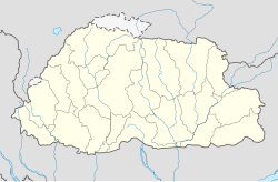
The town is located at the south-eastern part of Bhutan and borders the Indian state of
446:
391:
196:
182:
323:
84:
71:
173:
297:
399:
309:
178:
112:
316:
301:
190:
407:
221:. Unsourced material may be challenged and removed.
172:
164:
156:
151:
143:
135:
130:
118:
100:
21:
355:"Darranga Mela - a place of tourism and business""
427:
8:
434:
420:
18:
16:Place in Samdrup Jongkhar District, Bhutan
281:Learn how and when to remove this message
44:
343:National Geospatial-Intelligence Agency
335:
171:
150:
142:
129:
99:
64:
30:
163:
155:
134:
117:
7:
388:
386:
219:adding citations to reliable sources
139:4.47 km (1.73 sq mi)
406:. You can help Knowledge (XXG) by
14:
390:
195:
105:
43:
36:
206:needs additional citations for
378:Satellite map at Maplandia.com
1:
300::བསམ་གྲུབ་ལྗོངས་མཁར་) is a
168:2,100/km (5,400/sq mi)
474:
453:Populated places in Bhutan
385:
306:Samdrup Jongkhar District
125:Samdrup Jongkhar District
65:
31:
147:173 m (568 ft)
458:Bhutan geography stubs
402:location article is a
215:improve this article
165: • Density
81: /
26:བསམ་གྲུབ་ལྗོངས་མཁར་
230:"Samdrup Jongkhar"
157: • Total
136: • Total
85:26.800°N 91.5050°E
57:Location in Bhutan
415:
414:
291:
290:
283:
265:
189:
188:
465:
436:
429:
422:
394:
387:
365:
364:
362:
361:
351:
345:
340:
294:Samdrup Jongkhar
286:
279:
275:
272:
266:
264:
223:
199:
191:
111:
109:
108:
96:
95:
93:
92:
91:
86:
82:
79:
78:
77:
74:
51:Samdrup Jongkhar
47:
46:
40:
23:Samdrup Jongkhar
19:
473:
472:
468:
467:
466:
464:
463:
462:
443:
442:
441:
440:
383:
374:
369:
368:
359:
357:
353:
352:
348:
341:
337:
332:
287:
276:
270:
267:
224:
222:
212:
200:
106:
104:
90:26.800; 91.5050
89:
87:
83:
80:
75:
72:
70:
68:
67:
61:
60:
59:
58:
55:
54:
53:
52:
48:
27:
24:
17:
12:
11:
5:
471:
469:
461:
460:
455:
445:
444:
439:
438:
431:
424:
416:
413:
412:
395:
381:
380:
373:
372:External links
370:
367:
366:
346:
334:
333:
331:
328:
289:
288:
203:
201:
194:
187:
186:
176:
170:
169:
166:
162:
161:
158:
154:
153:
149:
148:
145:
141:
140:
137:
133:
132:
128:
127:
122:
116:
115:
102:
98:
97:
63:
62:
56:
50:
49:
42:
41:
35:
34:
33:
32:
29:
28:
25:
22:
15:
13:
10:
9:
6:
4:
3:
2:
470:
459:
456:
454:
451:
450:
448:
437:
432:
430:
425:
423:
418:
417:
411:
409:
405:
401:
396:
393:
389:
384:
379:
376:
375:
371:
356:
350:
347:
344:
339:
336:
329:
327:
325:
320:
318:
313:
311:
307:
303:
299:
295:
285:
282:
274:
263:
260:
256:
253:
249:
246:
242:
239:
235:
232: –
231:
227:
226:Find sources:
220:
216:
210:
209:
204:This article
202:
198:
193:
192:
184:
180:
177:
175:
167:
159:
146:
138:
126:
123:
121:
114:
103:
94:
66:Coordinates:
39:
20:
408:expanding it
397:
382:
358:. Retrieved
349:
338:
321:
314:
304:and seat of
293:
292:
277:
268:
258:
251:
244:
237:
225:
213:Please help
208:verification
205:
324:Lhotshampas
88: /
447:Categories
360:2024-05-13
330:References
241:newspapers
152:Population
174:Time zone
144:Elevation
76:91°30.3′E
298:Dzongkha
271:May 2024
120:District
255:scholar
101:Country
73:26°48′N
400:Bhutan
310:Bhutan
257:
250:
243:
236:
228:
113:Bhutan
110:
398:This
317:Assam
262:JSTOR
248:books
179:UTC+6
160:9,325
404:stub
302:town
234:news
131:Area
308:in
217:by
183:BTT
449::
312:.
435:e
428:t
421:v
410:.
363:.
296:(
284:)
278:(
273:)
269:(
259:·
252:·
245:·
238:·
211:.
185:)
181:(
Text is available under the Creative Commons Attribution-ShareAlike License. Additional terms may apply.