270:
131:
25:
238:. The path crosses the river on Arrow Highway next to the main spillway, then loops back to climb a steep ramp up to the rim of the dam. The path traces the rim of the dam around to the east of the flood basin and park, with access at Azusa Canyon Drive (main entrance to park). The path ends at State Route 39 where it exits the canyon in the north of
290:
297:
The
Commuter Bikeway Signage project involves the placement of signs and pavement markings along the river bike paths including the San Gabriel River path. This project is currently in the design phase, which will include an evaluation of signage at San Gabriel River Parkway to inform bicyclists that
282:
Maintained by Los
Angeles County Department of Public Works Road Maintenance Division, swept on a scheduled basis. South of Wardlow, the city of Long Beach is responsible. According to LADPW, Public Works currently has two projects underway to improve the condition of the bike path between Wilderness
286:
The San
Gabriel River Bike Path Rehabilitation project involves re-paving, striping the pavement, and updating the gates on the section of path from the Whittier Narrows Dam to Florence Avenue.
624:
215:, the path switches from the East side of the river to the West side of the river over the San Gabriel River Parkway Bridge, which is designated as a bike route by the city of
448:
42:
269:
619:
441:
89:
61:
614:
508:
108:
68:
634:
401:
that use the bike path frequently and interface with the LA County Dept. of Public Works and cities from
Lakewood to the ocean (
629:
434:
75:
563:
533:
457:
416:
262:
South of the San
Bernardino Freeway (I-10), under the Southern Pacific (Metrolink commuter rail) railroad bridge, is a rodeo.
193:
181:
46:
639:
312:
57:
558:
498:
246:
342:
583:
250:
35:
588:
578:
503:
317:
543:
468:
322:
227:
265:
North of the Pomona Valley
Freeway (SR-60) is the confluence of the San Jose Creek and the San Gabriel River.
573:
538:
483:
478:
216:
185:
553:
528:
488:
410:
406:
201:
82:
593:
568:
402:
398:
370:
548:
513:
493:
382:
189:
130:
376:
160:
388:
239:
205:
212:
523:
518:
473:
223:
608:
235:
298:
the bike path switches from one side of the river to the other at this location.
421:
24:
197:
231:
177:
426:
307:
253:
to the San
Gabriel River bike trail called the Emerald Necklace Gateway.
289:
343:"New bike path connects the San Gabriel River Bike Trail to Metro"
288:
268:
430:
18:
273:
The trail along the southern segment of the San
Gabriel River
222:
From
Whittier Narrows, the path follows the River north into
394:
156:
148:
140:
123:
49:. Unsourced material may be challenged and removed.
347:KPCC - NPR News for Southern California - 89.3 FM
625:Transportation in Los Angeles County, California
442:
8:
449:
435:
427:
379:Middle part of the San Gabriel River Trail
397:A group of cyclists that live in or near
385:Lower part of the San Gabriel River Trail
373:Upper part of the San Gabriel River Trail
109:Learn how and when to remove this message
16:Cycling route in Southern California, USA
334:
120:
188:and onto street bike trails near the
7:
395:Lakewood Accountability Action Group
47:adding citations to reliable sources
204:. The northern segment begins near
14:
417:City of Whittier Project Summary
129:
23:
413:) in maintaining the bike path.
34:needs additional citations for
620:San Gabriel River (California)
293:Near Rynerson Park in Lakewood
58:"San Gabriel River Bike Trail"
1:
383:Lower San Gabriel River trail
371:Upper San Gabriel River trail
313:Shoreline Pedestrian Bikepath
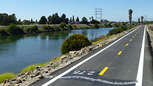
176:) is a 28-mile (45 km)
135:San Gabriel River Bike Trail
124:San Gabriel River Bike Trail
377:Mid San Gabriel River trail
283:Park and Whittier Narrows.
247:Duarte/City of Hope station
245:There is a connection from
656:
615:Bike paths in Los Angeles
464:
391:Pictures along the trail.
318:Los Angeles River Bikeway
128:
544:Marvin Braude Bike Trail
323:El Dorado Park Bike Path
635:Pico Rivera, California
389:San Gabriel River trail
186:El Dorado Regional Park
170:San Gabriel River Trail
144:28 mi (45 km)
630:Long Beach, California
458:Los Angeles Bike Paths
411:Seal Beach, California
407:Long Beach, California
294:
274:
292:
272:
211:Traveling north from
640:Whittier, California
399:Lakewood, California
43:improve this article
494:California Aqueduct
200:. The South end is
190:Alamitos Bay Marina
295:
275:
194:Los Angeles County
602:
601:
574:Santa Clara River
564:San Gabriel River
208:Recreation Area.
182:San Gabriel River
166:
165:
119:
118:
111:
93:
647:
451:
444:
437:
428:
358:
357:
355:
354:
339:
257:Trail highlights
206:Whittier Narrows
133:
121:
114:
107:
103:
100:
94:
92:
51:
27:
19:
655:
654:
650:
649:
648:
646:
645:
644:
605:
604:
603:
598:
569:Santa Ana River
559:San Diego Creek
460:
455:
367:
362:
361:
352:
350:
341:
340:
336:
331:
304:
280:
259:
213:Wilderness Park
172:(also known as
136:
115:
104:
98:
95:
52:
50:
40:
28:
17:
12:
11:
5:
653:
651:
643:
642:
637:
632:
627:
622:
617:
607:
606:
600:
599:
597:
596:
591:
586:
581:
576:
571:
566:
561:
556:
551:
546:
541:
536:
531:
529:Kenneth Newell
526:
521:
516:
511:
506:
501:
499:Chandler Blvd.
496:
491:
486:
481:
476:
471:
465:
462:
461:
456:
454:
453:
446:
439:
431:
425:
424:
419:
414:
392:
386:
380:
374:
366:
365:External links
363:
360:
359:
333:
332:
330:
327:
326:
325:
320:
315:
310:
303:
300:
279:
276:
267:
266:
263:
258:
255:
224:South El Monte
164:
163:
158:
154:
153:
150:
146:
145:
142:
138:
137:
134:
126:
125:
117:
116:
31:
29:
22:
15:
13:
10:
9:
6:
4:
3:
2:
652:
641:
638:
636:
633:
631:
628:
626:
623:
621:
618:
616:
613:
612:
610:
595:
592:
590:
587:
585:
584:Sepulveda Dam
582:
580:
577:
575:
572:
570:
567:
565:
562:
560:
557:
555:
552:
550:
549:Park to Playa
547:
545:
542:
540:
537:
535:
532:
530:
527:
525:
522:
520:
517:
515:
512:
510:
509:Culver Median
507:
505:
502:
500:
497:
495:
492:
490:
487:
485:
482:
480:
479:Ballona Creek
477:
475:
472:
470:
467:
466:
463:
459:
452:
447:
445:
440:
438:
433:
432:
429:
423:
422:Metro website
420:
418:
415:
412:
408:
404:
400:
396:
393:
390:
387:
384:
381:
378:
375:
372:
369:
368:
364:
348:
344:
338:
335:
328:
324:
321:
319:
316:
314:
311:
309:
306:
305:
301:
299:
291:
287:
284:
277:
271:
264:
261:
260:
256:
254:
252:
248:
243:
241:
237:
233:
229:
225:
220:
218:
214:
209:
207:
203:
199:
195:
191:
187:
183:
179:
175:
171:
162:
159:
155:
151:
147:
143:
139:
132:
127:
122:
113:
110:
102:
91:
88:
84:
81:
77:
74:
70:
67:
63:
60: –
59:
55:
54:Find sources:
48:
44:
38:
37:
32:This article
30:
26:
21:
20:
594:Tujunga Wash
579:Santa Monica
504:Coyote Creek
489:Browns Creek
351:. Retrieved
349:. 2016-09-16
346:
337:
296:
285:
281:
244:
236:Santa Fe Dam
228:Baldwin Park
221:
210:
173:
169:
167:
161:lacounty.gov
105:
99:October 2015
96:
86:
79:
72:
65:
53:
41:Please help
36:verification
33:
484:Bolsa Chica
469:Arroyo Seco
278:Maintenance
217:Pico Rivera
609:Categories
589:The Strand
539:Long Beach
534:L.A. River
353:2022-08-13
329:References
202:Seal Beach
198:California
180:along the
69:newspapers
554:Rio Hondo
232:Irwindale
178:bike path
474:Backbone
403:Cerritos
308:CicLAvia
302:See also
184:through
249:of the
234:to the
157:Website
83:scholar
524:G Line
514:Duarte
251:L Line
141:Length
85:
78:
71:
64:
56:
240:Azusa
152:Mixed
90:JSTOR
76:books
519:Expo
230:and
174:SGRT
168:The
62:news
192:in
149:Use
45:by
611::
409:,
405:,
345:.
242:.
226:,
219:.
196:,
450:e
443:t
436:v
356:.
112:)
106:(
101:)
97:(
87:·
80:·
73:·
66:·
39:.
Text is available under the Creative Commons Attribution-ShareAlike License. Additional terms may apply.